Wiang Kum Kam: The First Capital of King Mangrai
Site at a Glance
- Rating
- 4.3
- Popularity
- Medium
- Country
- Thailand
- Primary era
- Medieval
- Eras represented
- Medieval, Early Modern
- Civilizations
- Unclassified
- Site type
- City
On this page30 sections
History
Wiang Kum Kam is an ancient walled settlement in Tha Wang Tan Subdistrict, Saraphi District, Chiang Mai Province, Thailand. Built by King Mangrai of the Ngoenyang kingdom in the late thirteenth century, it became his first capital after his conquest of Hariphunchai, the Mon kingdom centered on modern Lamphun. The settlement was a new royal residence and an early expression of the Lanna kingdom’s political and cultural development.
Mangrai’s capital
Mangrai lived at Wiang Kum Kam for about five years. He then moved north and founded Chiang Mai on 27 March 1292, making Wiang Kum Kam an experimental predecessor to the later capital. Its urban plan included defensive works, religious buildings, residential areas, a market, and an extensive royal palace complex. The city also stood within the cultural sphere of Hariphunchai, whose Mon artistic and religious traditions influenced several of its monuments.
Wiang Kum Kam continued to flourish under the Mangrai dynasty until approximately the late sixteenth century. Repeated flooding made the settlement increasingly unsuitable for occupation. A later war between the Thai and Burmese kingdoms has also been proposed as a factor in its abandonment, although flooding was the most direct force shaping the site’s later history.
Flooding, burial, and abandonment
The Ping River eventually changed course, while a major flood covered much of the settlement with sediment. The precise date of this event is uncertain, but it probably occurred between 1558 and 1774. Severe flooding recorded in 1524–1525 has also been associated with the destruction of the old city. The burial took place during a period when Chiang Mai was under Burmese rule, from 1558 to 1774, and Wiang Kum Kam was subsequently forgotten.
Earth and sand accumulated to a depth of roughly 1.5 to 2 metres over many temples and other remains. Wat I Khang was buried most deeply, followed by Wat Pu Pia and Wat Ku Padom. The flood risk has continued into modern times. In 2005, the area was flooded three times when the Ping River overflowed. More than two centuries after the old settlement was abandoned, a new community called Chang Kham village was established in the area.
Rediscovery and archaeological work
Archaeological interest increased in 1984, when Fine Arts Department Unit 4 identified remains around Wihan Kan Thom at Wat Chang Kham. Excavation, clearance, restoration, and investigation continued through 2002. Chiang Mai University carried out investigations in 1986–1987, and further temple foundations were exposed between 2001 and 2002.
Early restoration concentrated on Wat Chang Kham and Wat Chedi Liam. Work then revealed many additional remains within a modern residential landscape. More than 40 archaeological sites and temples, including ruined and active monasteries, have been identified in and around Wiang Kum Kam. The area is maintained as an archaeological and educational site illustrating Lanna architecture, art, and culture. Wat Chang Kham serves as the principal center for the archaeological area, while Wat Chedi Liam remains the principal active ancient temple with resident monks.
Remains
Wiang Kum Kam occupied the Chiang Mai–Lamphun plain near the eastern side of the present Ping River, although the settlement originally stood on the river’s western bank. Its rectangular plan measured approximately 850 metres along a southeast–northeast axis and about 600 metres across. Defensive works included a moat supplied by the Ping River and palisades, an enclosure made chiefly of wooden stakes. The city extended along an earlier river channel, and later alluvial deposits buried many of its buildings.
Principal temples
Wat Kan Thom and Wat Chang Kham
Wat Kan Thom, also called Wat Chang Kham, was built by Mangrai around 1291. Its principal chedi, a Buddhist reliquary monument, stands on a low terrace used for walking around the structure. The square lower section measures approximately 12 metres on each side and rises about 18 metres high. Another description presents the base as a cube-like structure surmounted by a Burmese-style stupa crowned with a hti, an umbrella-like finial.
Four shrine niches occupy the sides of the principal chedi. They contain four seated Buddha images on the lower level and two standing images above. A second chedi has a pavilion-like mandapa form with a bell-shaped finial. The temple also contains a vihara, a Buddhist assembly or image hall. Excavation around its foundations uncovered small terracotta votive tablets bearing Buddha figures in the Hariphunchai style and characters in the Mon script. Similar terracotta images were set around the vihara foundation. A sacred bodhi tree at the temple was grown from seed brought from Lanka.
Wat Chedi Liam
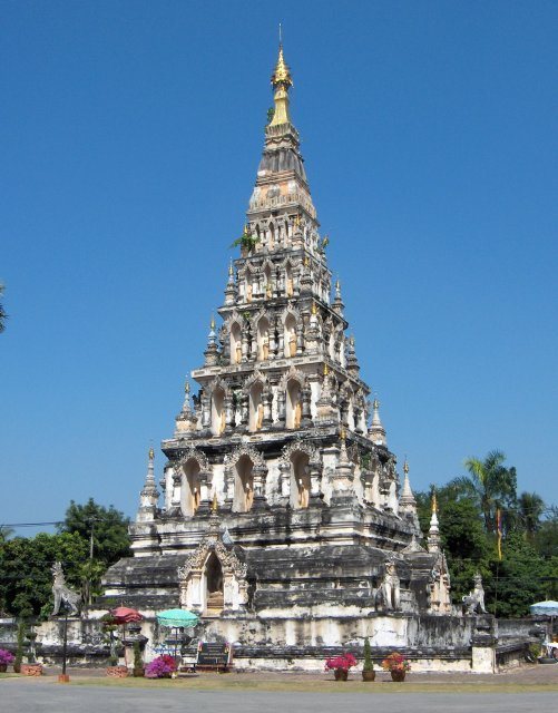
Wat Chedi Liam, formerly called Wat Ku Kham, was built by Mangrai around 1288 and was originally known as the Temple of the Golden Stupa. Its principal chedi is a five-level stepped monument in a Mon or Dvaravati-related style. Dvaravati was an early mainland Southeast Asian artistic tradition associated especially with Mon cultural centers. The monument was modeled on the chedi of Wat Phra That Hariphunchai in Lamphun.
The chedi has a square foundation described as eight wa and one sok in size, with a height of 22 wa. Niches on all four sides contain standing Buddha images, with 15 niches on each side and 60 in total. A Burmese hti crowns the monument. It was probably added during an early twentieth-century restoration by a Burmese merchant. Wat Chedi Liam remains an active religious site and retains resident monks.
Temples around the central settlement
Wat Pu Pia
Wat Pu Pia preserves a comparatively complete temple layout, including a mandapa-style principal chedi, a vihara, an ubosot or principal ordination hall, a spirit house, an altar, and substantial stucco decoration. Before excavation, the complex lay beneath almost two metres of earth in an orchard. The vihara staircase is decorated with naga heads.
Wat I Khang
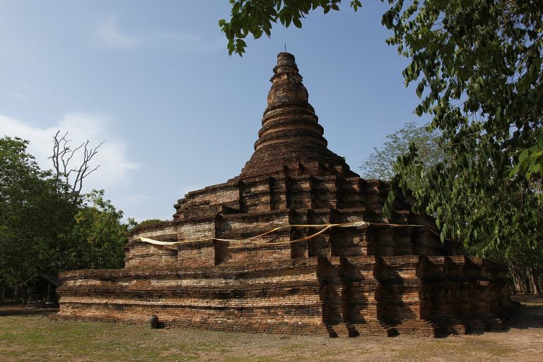
Wat I Khang is a ruined temple traditionally dated to the sixteenth or seventeenth century. Its name refers to the langur monkeys that once occupied the overgrown ruins. The remains include a large vihara and a circular, bell-shaped chedi on a shared base. The vihara measures approximately 20 by 13.5 metres, and the temple was buried particularly deeply beneath sediment.
Wat That Khao
Wat That Khao, also called Wat Phra That Khao, contains a vihara, chedi, ubosot, and mandapa. Its name comes from the chedi’s formerly white, lime-plastered surface. The complex was built in two phases. The first included the chedi, vihara, and ubosot. After deterioration, the chedi base was enlarged and a mandapa was added to house a Buddha image.
Wat Phrachao Ong Dam
Wat Phrachao Ong Dam lies near the northwestern city wall. Before excavation, the area was a longan orchard with two earthen mounds locally associated with Mangrai and a black Buddha. The remains include several viharas, an entrance arch, walls, and a chedi. The temple’s name is associated with a blackened bronze Buddha image found there.
Wat Phaya Mangrai
Wat Phaya Mangrai lies southeast of Wat Phrachao Ong Dam. The Fine Arts Department assigned its modern name because the temple’s original history was not preserved in a historical account. Its unusual vihara has no principal stairway at the front. The main stairway is on the left when facing the front of the building. Traces of stucco arranged in a glass-inlaid pattern survive on the chedi.
Wat Hua Nong
Wat Hua Nong lies near the northern city wall. Its remains include a large entrance arch, ubosot, mandapa, vihara, and chedi. Stucco figures of qilins, lions, and swans decorate the entrance arch.
Wat Kum Kam
Wat Kum Kam lies north of Wat Kan Thom. Its remains include a vihara with a chamber identified as a gandhakuti, a shrine or residence associated with the Buddha in Buddhist temple tradition, together with an octagonal chedi.
Wat That Noi
Wat That Noi, also called Wat Noi, lies west of Wat Kan Thom. Before excavation, two earthen mounds occupied by houses marked the site, and traces of illicit digging for valuables were found. The remains include a rectangular vihara facing northeast, with a front staircase, a side staircase, a brick floor, and a rear shrine containing a stucco principal Buddha image.
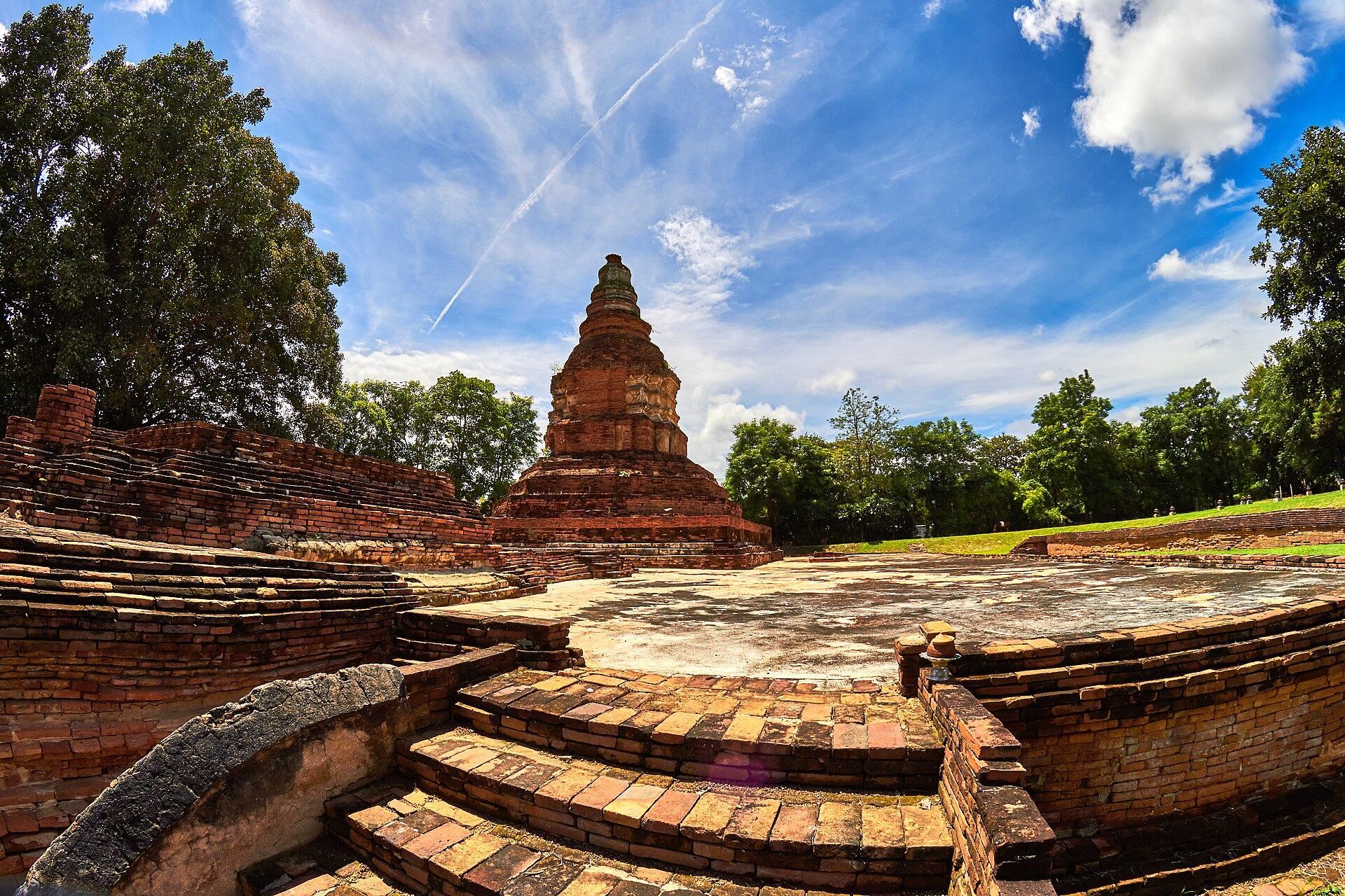
The chedi has a square lower base measuring approximately 13.35 by 13.35 metres and 1.64 metres high. A smaller square structure, approximately 6.20 by 6.20 metres, rises above it, creating a broad lower monument with a comparatively small upper body.
Temples on the edges of Wiang Kum Kam
Wat Mai Song
Wat Mai Song occupies the southeastern corner of Wiang Kum Kam, in an area now surrounded by rice fields. Its remains include a vihara, an octagonal chedi, and the base of an entrance arch with surrounding walls. The name comes from a large tree that formerly grew on the site.
Wat Ku Khao
Wat Ku Khao lies beside the Chiang Mai–Lamphun road. Excavation exposed a boundary wall and entrance arch behind the chedi. The principal chedi has a tall, solid, four-sided Lanna-style body without Buddha niches, an octagonal lotus base, and a bell-shaped upper section. The vihara preserves lotus-base ornament and the base of a former altar.
Wat Ku Padom
Wat Ku Padom lies southwest of the walled city, outside the main enclosure. Its remains include a large vihara with a broad base, a staircase whose balustrade ends in a local ornamental form, and the base of a chedi. A surrounding boundary wall has an entrance arch. The temple is dated approximately to Thai Buddhist-era centuries 21–22, a chronological system that differs from Western century labels.
Wat Bot
Wat Bot lies west of Wiang Kum Kam, outside the main enclosure. Its remains consist of a vihara surviving as a base and a chedi with a square base.
Wat Ku Ai Lan and Wat Ku Ai Si
Wat Ku Ai Lan is a small temple north of Wiang Kum Kam. Its remains include an east-facing vihara, a chedi with a square base, an altar, a surrounding boundary wall, and an eastern entrance arch. Another small temple, Wat Ku Ai Si, preserves a vihara, a chedi surviving as a base, and an altar.
Wat Ku Makuea
Wat Ku Makuea lies inside the eastern part of Wiang Kum Kam. After the overlying earth was removed, a chedi and vihara were found standing on a shared base and facing east. The temple’s name comes from a tree that grew over the ruins.
Wat Ku Lit Mai and Wat Ku Jok Pok
Wat Ku Lit Mai lies in the southern part of the settlement. Its name refers to a dok, or Indian trumpet, tree that grew on the temple mound. The remains include an east-facing vihara, a chedi behind it surviving only as a base, an octagonal chedi, an entrance arch, and a surrounding boundary wall. Wat Ku Jok Pok lies outside the southeastern wall and preserves a vihara and the base of a chedi.
Temples near the Ping River and outer area
Wat Nan Chang
Wat Nan Chang lies near the Ping River. Its entrance arch carries limited stucco decoration, and a path leads from the arch to a vihara with stucco ornament at the base of the principal Buddha image. Behind the vihara stands a chedi with two superimposed square-base levels, although its main body has collapsed. A mandapa is offset from the chedi, and an ubosot lies farther beyond it.
Wat Nong Phueng
Wat Nong Phueng lies west of the Chiang Mai–Lamphun road. It may have originated during the Wiang Kum Kam or early Chiang Mai period, while an earlier Hariphunchai foundation is also possible. Terracotta votive objects in the Lamphun style were found at the temple. Its principal feature is a vihara containing a reclining Buddha approximately 39 metres long.
Wat Phan Lao
Wat Phan Lao is an abandoned temple outside the northern side of Wiang Kum Kam near Tha Wang Tan Road. Its traditional name may preserve the memory of a military or noble title associated with a patron named Lao, although that interpretation remains conjectural. Scattered brickwork, fragments of Buddha images, and unidentified structural remains survive, while further temples and houses are believed to remain buried beneath the ground.
Other surviving temple remains
Wat Si Bun Rueang was rebuilt and restored in a later period and currently has monks in residence. Wat Khoi Sam Ton lies in the northeastern part of the Wiang Kum Kam area, and its name refers to three khoi trees that grew at the temple. Wat Sao Hin lies in Nong Hoi Subdistrict, Chiang Mai. Together with the other excavated sites, these temples illustrate the varied condition of the ancient settlement, where active religious buildings stand alongside ruined complexes, foundations, partially buried structures, and isolated architectural elements.