Whorlton Castle: A Medieval Norman Fortress in North Yorkshire


Site at a Glance
- Rating
- 4.2
- Popularity
- Low
- Country
- United Kingdom
- Primary era
- Medieval
- Eras represented
- Medieval
- Civilizations
- English, Norman
- Site type
- Military
- Remains
- Castle
On this page15 sections
History
Whorlton Castle is a ruined medieval castle in England, United Kingdom, near the abandoned village of Whorlton in North Yorkshire. The Normans established it in the early 12th century as a motte-and-bailey fortress overlooking the road between Thirsk and Stokesley on the western edge of the North York Moors. Its position on Castle Bank placed the stronghold above the road and alongside the settlement and church that formed part of its wider estate.
Norman origins and medieval decline
A motte-and-bailey castle combined a raised defensive mound with an enclosed courtyard that could contain buildings, domestic facilities, and a settlement. Whorlton’s first fortress was probably built largely of timber. The estate had been associated with Robert, Count of Mortain, the half-brother of William the Conqueror, when Whorlton appeared in the Domesday Book, the survey of English landholding and resources completed in 1086. The property later passed to the de Meynell family, who founded the castle.
During the 13th century, the castle was also called Hwernelton or Potto Castle. Unlike many motte-and-bailey fortifications, it continued in use through the Middle Ages and into the early modern period, the era broadly extending from the 16th to the 18th centuries. Its condition nevertheless deteriorated. The first castle was disused or dismantled during the early 14th century, and by 1343 it was already being described as a ruin.
The Darcy rebuilding
In the mid-14th century, marriage transferred the estate to John Darcy, Lord Darcy of Knayth, a nobleman closely connected with the royal court. He substantially remodelled the castle, levelling the earlier motte and creating the foundations for a new keep and fortified gatehouse. This rebuilding established the principal stone remains visible at the site today.
The Darcy family retained Whorlton until 1418. After Philip Darcy died, the inheritance passed to his daughter Elizabeth Darcy, who was married to Sir James Strangeways. The Strangeways held the castle until 1541, when an inheritance dispute caused the property to pass to the Crown.
Lennox ownership and royal associations
Henry VIII granted Whorlton Castle and its estate to Matthew Stewart, 4th Earl of Lennox. His eldest son was Henry Stuart, Lord Darnley. In autumn 1561, Margaret Douglas, Countess of Lennox, may have written from Whorlton Castle to Mary, Queen of Scots, proposing a marriage between Mary and Darnley.
Local tradition later claimed that the marriage contract was signed at Whorlton in 1565. The contract was actually signed at Stirling Castle. The tradition nevertheless reflects the castle’s association with the Lennox family and with the political marriage that joined Mary, Queen of Scots, and Darnley.
Later ownership and deterioration
Whorlton eventually returned to the Crown and had deteriorated again by 1600, when its buildings were described as old and ruinous. In 1603, the manor was granted to Edward Bruce, later Lord Bruce of Kinloss. His younger son Thomas Bruce received the title Lord Bruce of Whorlton in 1641, and Thomas’s son Robert Bruce became the first Earl of Ailesbury in 1664.
The Bruce family retained the castle and manor until the late 19th century, when they sold them to James Emerson of Easby Hall. In 1875, a large quantity of stone was taken from the ruins to build the church at Swainby. By the early 19th century, most of the keep had already disappeared. In the mid-20th century, Osbert Peake, 1st Viscount Ingleby, acquired the property as part of a shooting estate, and it remains privately owned.
Protection and conservation
The castle received listed status in 1928 and is now a Grade I listed building, the highest category of listed-building protection in England. The castle, the deserted village of Whorlton, its church, the surrounding landscape, and the archaeological earthworks also form part of a scheduled monument protected under national law.
The Ministry of Works carried out structural repairs to the gatehouse in the 1960s, but the building continued to be exposed to weathering. Repeated vandalism later placed it on the Heritage at Risk Register, which identifies important heritage assets vulnerable through neglect, damage, or other threats.
In a 2005 report, the North York Moors National Park Authority, English Heritage, and the owner considered several conservation approaches. These included retaining the ruins with stronger security, converting the gatehouse into a house or holiday property, and involving local volunteers in management and maintenance. Conversion was recommended, and English Heritage partly funded a feasibility study. The proposal failed after the Vivat Trust, the charitable organization that had advanced the scheme, entered administration.
Remains
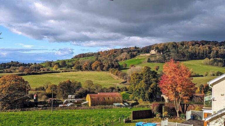
Whorlton Castle occupies the edge of Castle Bank, a ridge between Faceby and Swainby above a small valley containing the Thirsk to Stokesley road. Its physical remains extend beyond the stone buildings. The archaeological landscape includes the motte, bailey, defensive ditch and outer bank, gatehouse, keep undercrofts, ornamental gardens, pond, deer park, cultivated medieval fields, deserted village, and church.
Motte and bailey earthworks
The original motte was roughly rectangular, measuring about 60 metres by 50 metres. A dry ditch surrounded it, reaching up to 20 metres in width and 5 metres in depth, with an outer bank rising as much as 2.5 metres. Most of the ditch survives, although a modern road destroyed its southeastern section. The motte adjoined a fortified enclosure that contained the village and church, linking the castle’s defensive earthworks with the settlement around it.
Gatehouse
Stone structure and entrances
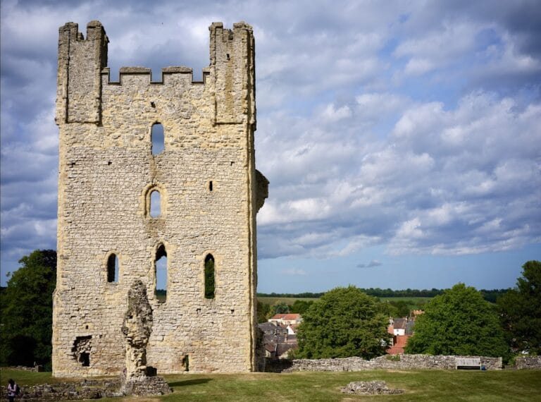
The mid-14th-century gatehouse is the principal surviving building. It is a roofless and floorless three-storey shell constructed from sandstone ashlar, carefully squared masonry used for finished wall faces. The rectangular structure measures 17.68 metres by 10 metres. Its exterior walls survive between approximately 6 and 8.5 metres high and are between 1.73 and 2.3 metres thick. The internal walls and floors have disappeared.
Two large segment-arched entrances pierce the gatehouse, one on each side, and each is flanked by cross-shaped windows. The entrances are approximately 3 metres wide and 3.3 metres high. Wooden or metal portcullises, vertically sliding defensive gates, once protected them. The grooves for the portcullises remain visible in the masonry.
Heraldic decoration
Above the eastern principal entrance is a row of three carved shields set into panels with curved, lobed edges. The central shield carries the Darcy arms, while the Meynell arms appear on the right and the Gray arms on the left. The Gray shield commemorates the late-14th-century marriage of Philip Darcy and Elizabeth Gray. A further shield above the row displays the Darcy and Meynell arms together, recalling the earlier marriage that united the two families and brought the castle to the Darcys.
Internal rooms and staircase
A vaulted central passage once ran through the gatehouse, and parts of it survive. Large rooms stood on either side, while smaller chambers built into the thick walls probably served as guardrooms. The entire upper floor formed a great hall. Remains of fireplaces can still be seen on the ground and first floors.
A spiral staircase was enclosed within a tower projecting from the northwestern wall. It was entered through a round-headed doorway in that wall rather than from the ground floor of the gatehouse. The stair can still be followed as far as the remains of the first floor, although the floor itself has gone.
Lennox house
The Lennox family built a house against the northwestern end of the gatehouse, beside the surviving keep ruins, in the late 16th or early 17th century. Samuel Buck’s 1725 view shows it as a large two-storey building with gabled dormer windows set within a steeply pitched roof. The house has not survived structurally, but its roofline remains visible on the northern side of the gatehouse.
Keep undercrofts
The keep stood about 22 metres west of the gatehouse at the opposite end of the bailey. Its surviving remains consist of fragments of vaulted cellars, or undercrofts, the largest measuring approximately 9 metres by 4 metres. These structures are thought to be Norman and may represent the oldest surviving masonry at Whorlton.
In the mid-19th century, a local farmer reportedly used the keep cellars as pigsties. The spaces have been described as tidied and accessible through small doors and steps, while earlier descriptions found them overgrown and partly filled with rubble.
Gardens, pond, and surrounding landscape
Much of the surrounding land retains visible medieval plough marks. In the late medieval period, two rectangular ornamental gardens were laid out immediately east of the bailey. Each garden measured about 40 metres by 20 metres and was enclosed by earthen banks approximately 1 metre high.
East of the gardens lies a rectangular pond approximately 190 metres long, 20 metres wide, and up to 3 metres deep. It has been suggested that the pond served as a fishpond, although its unusually large size makes that interpretation uncertain. A deer park was laid out south of the castle, and local tradition associates it with royal hunting, specifically claiming that Edward II hunted there.