Venta Silurum: Roman Civitas Capital of the Silures in Wales



Site at a Glance
- Rating
- 4.7
- Popularity
- Very Low
- Country
- United Kingdom
- Primary era
- Classical
- External website
- Open
- Eras represented
- Classical, Medieval
- Civilizations
- Norman, Roman
- Site type
- City
On this page17 sections
History
Venta Silurum was a Roman town in Caerwent, United Kingdom, and the administrative centre, or civitas, of the Silures in Roman Britain. A civitas was a Roman urban and administrative community based on a conquered tribal territory and governed through a local council. The name means “market town of the Silures” or “town of the Silures.” Roman settlement began around AD 74–75, after the governor Frontinus decisively defeated the Silures, and the town developed as a mainly civilian centre rather than a military fortress.
Roman foundation and civic development
The Silures were a powerful tribal community occupying much of southeastern Wales. They resisted the Roman conquest and defeated Roman forces in AD 52, but their defeat under Frontinus around AD 74–75 brought the area into sustained Roman occupation. Venta Silurum was established during this period, probably in connection with an earlier Roman fort whose site may have preceded the town.
During the second century, buildings were dispersed along the road between Glevum and Isca Augusta. Shops, workshops, houses, and baths developed during the early second century, while a more regular urban plan emerged toward the end of that century. Formal self-government probably arrived during the reign of the emperor Hadrian, who ruled from AD 117 to 138, and certainly existed by the early third century. The town’s local council, or ordo, is named in an inscription honouring Tiberius Claudius Paulinus, confirming that the Silures were governed through a civic body with authority to make decisions.
Paulinus had commanded Legio II Augusta at Caerleon during the reign of Caracalla, who was emperor from AD 211 to 217. He later held offices in the Roman provinces of Gallia Narbonensis and Gallia Lugdunensis before becoming governor of Britannia Inferior in AD 220. His commemorative stone probably marked assistance to, or a gift for, the town. The inscription’s reference to the civitas Silurum provides direct evidence for Venta Silurum’s political status and local institutions.
Late Roman transformation and early medieval traditions
Stone defences were added during the third century, probably toward its end, and strengthened during the fourth. The northern and southern walls received stone towers around AD 349–350, and a small garrison may have been stationed at the town during this period. Venta Silurum became less important in the later fourth century. The forum-basilica probably remained in use until about AD 390, while a house at Pound Lane was occupied at the beginning of the fifth century.
Occupation continued into the fifth century, but the town was abandoned during that century. Early Christian worship continued, and Venta Silurum may have had a bishop. A late Roman bowl bearing the chi-rho, an early Christian monogram formed from the first two Greek letters of the word “Christ,” provides evidence for Christian activity. Traditional accounts state that Saint Tatheus founded a monastery at the site around the sixth century, and the present church occupies part of an early Christian cemetery.
The name Venta survived in the name of the early medieval kingdom of Gwent, while the settlement later became known as Caerwent. A tradition places the court of Caradog Freichfras, a semi-legendary figure associated with Gwent, at Caerwent before it was moved to Portskewett around the sixth century. In the late eleventh century, a large Norman motte was built in the southeastern corner of the Roman enclosure, using the Roman wall. Part of that wall was removed to separate the motte from the rest of the circuit.
Excavation and conservation
Octavius Morgan began excavating Venta Silurum in 1855. A major campaign organized by the Clifton Antiquarian Club of Bristol between 1899 and 1913 exposed much of the town. Alfred Hudd and Thomas Ashby directed the work, which was supported by Lord Tredegar. Further investigations uncovered part of the public baths in 1923, major sections of the southern defences in 1925 under V. E. Nash-Williams, and houses, shops, and a villa near Pound Lane in 1946–1947.
A substantial early medieval cemetery outside the eastern gate was found in 1973. The National Museum of Wales began a further programme with Cadw in 1981, and excavations from 1984 to 1995 examined a northwestern villa, the central forum-basilica, and a nearby Romano-Celtic temple. Work in 2008 and 2010 extended knowledge of the town. Many earlier finds are displayed at Newport Museum and Art Gallery, while the remains are managed by Cadw as Caerwent Roman Town.
Remains
Venta Silurum occupied about 18 hectares on low ground in the centre of a broad valley, near fertile agricultural land and approximately 3.2 kilometres from the River Severn and the Severn Estuary. The main road linking Glevum and Isca Augusta crossed the settlement. An approximately square or rectangular enclosure with rounded corners contained a regular grid of about twenty urban blocks, or insulae. The streets were relatively close together, and buildings occupied the blocks densely.
Civic centre and religious buildings
Forum-basilica
The forum-basilica stood at the centre of the town, immediately northwest of the temple, where the principal north-south and east-west roads crossed. A forum-basilica combined a public civic square with a large administrative and judicial hall. The rectangular forum was paved and bordered on three sides by narrow shops or offices. Access was from the southern side beside the road, and the northeastern shop is visible today.
The basilica occupied the northern side of the forum on an east-west axis and measured about 55 metres in length. Its eastern two-thirds have been excavated. A nave and northern compartments were separated by Corinthian columns made from local sandstone, each approximately nine metres high. A rectangular eastern extension served as a courtroom or tribunal, while an open room in the centre of the northern side contained an aedes, or shrine. The curia, the council chamber, stood immediately west of the shrine. Built in the early second century, the complex was rebuilt in the late third century, probably because of wood rot.
Central temple
A temple in the centre of the town was built during the fourth century. A surrounding wall enclosed it, and the entrance was on the southern side. Its surviving foundations form two nested rectangular plans. Projecting walls at the front mark the former stairway, while a small apse at the rear of the inner chamber indicates a statue niche. The building was probably a Romano-Celtic temple, with a central shrine chamber surrounded by a colonnade. The deity worshipped there is unknown.
Western temple
A second temple stood outside the western town wall and had an octagonal plan. Other religious buildings were present within the town, and inscriptions record dedications to Mars and to Celtic deities including Lenus and Ocelus.
Baths, shops, and houses
Public baths
The public baths stood opposite the forum across the main east-west road. Excavation has revealed the front hall and part of the frigidarium, the cold room of a Roman bath complex. The drainage outlet was raised when the southern and northern gates were closed during the late Roman period, indicating that the baths continued operating after those changes to the town’s defences.
Commercial buildings and houses
Long, narrow shops and workshops lined the principal street, while houses occupied the side streets. Some residences were large. A building near the southern gate was unusually extensive and may have been a mansio, or lodging establishment. In the northeastern quarter, an elliptical structure measuring approximately 44 by 37 metres was built over earlier stone houses. It may have been an amphitheatre, although the lack of an outer wall leaves open the possibility that it was a market for live animals.
Pound Lane follows the northern side of the main road between the forum and the western gate. Around AD 100, two narrow shops stood there with residential rooms behind them, and the western shop contained a blacksmith’s workshop. The eastern shop was later demolished. Two wings were then added to the remaining house, creating a U-shaped building around a central courtyard, with a colonnade connecting the courtyard to the street. The original rooms were later divided into smaller spaces.
Another house north of Pound Lane had wings arranged around a central courtyard. A house northwest of the lane, excavated between 1981 and 1984, contained rectangular courtyards, two rooms heated by a hypocaust, and a corridor with a geometric mosaic. A hypocaust was an underfloor-heating system that circulated hot air beneath the floor. The mosaic was reburied after excavation to protect it from exposure.
Mosaics and excavated finds
A coloured tessellated pavement showing different kinds of fish was found in 1881 in the garden of a cottage. A tessellated pavement is made from small fitted pieces, usually stone or ceramic. Excavation of House VIII South in 1901 revealed two mosaic floors, including the Four Seasons mosaic, now held at Newport Museum and Art Gallery.
Excavations in 2008 exposed narrow shops and a villa with painted walls, Roman frescoes, and mosaic floors. Finds from the work included a bone penknife handle depicting two fighting gladiators, coins, Roman glassware, ceramics, human and animal bones, lead patches used to repair water pipes, and further mosaic fragments.
Town walls and gates
Defensive circuit
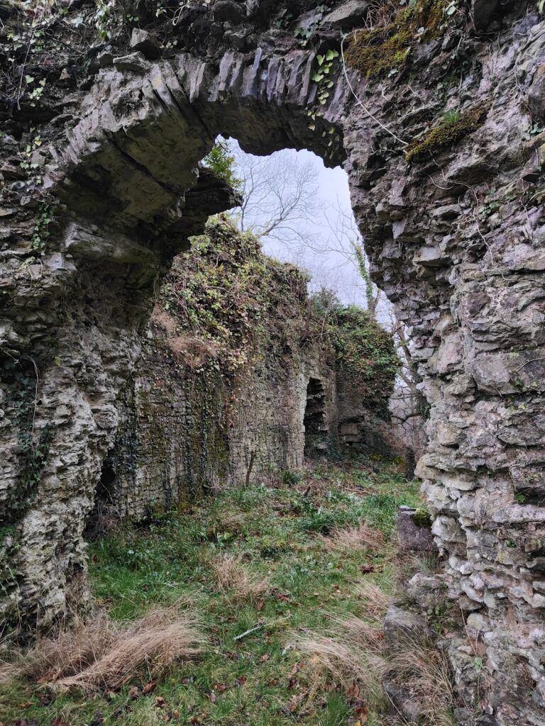
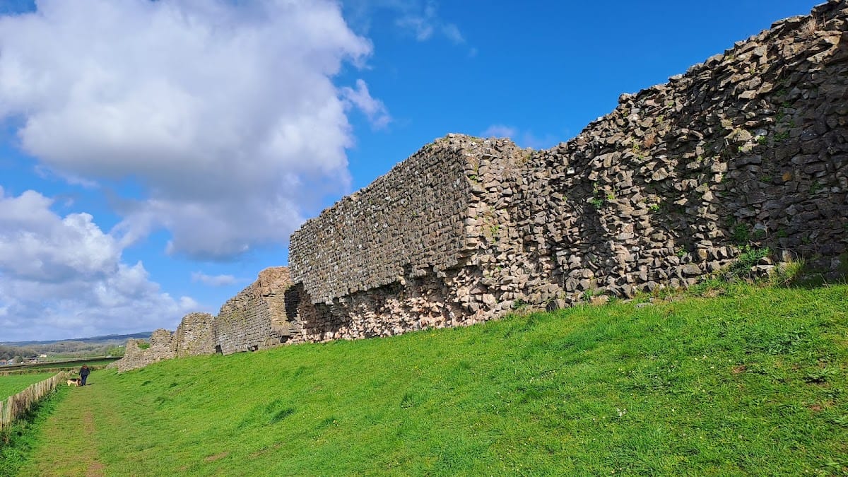
The stone walls enclosed more than 1.6 kilometres and were about three metres thick at the base. They may originally have reached approximately 7.5 metres in height, while surviving sections rise to five metres. Four gates stood at the centre of the enclosure’s four sides, each flanked by two square towers. The southern and northern gates were blocked during the late Roman period. At the eastern gate, the modern road lies approximately 1.2 metres below the original Roman road.
The town may first have been protected by an earth-and-timber rampart. By the late second century, a V-shaped ditch and an earth bank with a palisade defended the settlement. The western gate preserves part of the southern wall of its southern tower and the foundations of the guardroom. Between the western gate and the southwestern corner, the wall averages three metres in height, with sections reaching five metres. Two external ditches lay beyond it. The inner ditch began 1.5 metres from the wall and was about 13.5 metres wide and up to 2.5 metres deep; the outer ditch was shallow and U-shaped, about 7.3 metres wide and 1.8 metres deep.
Southern and northern defences
The southern wall was built in fourteen sections and preceded by two ditches approximately nine metres wide and two metres deep. Six hollow towers were added around the middle of the fourth century. Each tower had two wooden floors, creating two storeys, together with a wooden platform. The fourth tower from the west survives to approximately four metres high.
At the eastern gate, only the inner part of the southern tower survives. The northern wall is less well preserved and reaches no more than about 1.6 metres. Its ditch lies approximately 23 metres to the north, averages nine metres in width, and was associated with five towers whose foundations remain visible. The northwestern tower survives to 2.4 metres and was probably built in AD 349–350. Before the northern gate was blocked, its passage was three metres wide.
Christian and commemorative remains
The Paulinus inscription, found at the town and now standing in the porch of St Stephen and St Tathan’s Church in Caerwent, preserves the name of the civitas Silurum and its governing council. Together with the lead-tin bowl marked with a chi-rho, the stone connects the civic remains with the continuation of Christian worship after the Roman town’s political and urban importance had declined.
Nearby sites