Teopantecuanitlan: An Early Formative Regional Center in Guerrero, Mexico
Site at a Glance
- Popularity
- Medium
- Country
- Mexico
- Primary era
- Iron Age
- Eras represented
- Bronze Age, Iron Age
- Civilizations
- Olmec
- Site type
- Settlement
- Remains
- Town
On this page17 sections
History
Teopantecuanitlan is an archaeological site in eastern Guerrero, Mexico, occupied from about 1400 to 500 BCE during the Formative Period, an early era of Mesoamerican history before the Classic Period. It became a regional center for nearby communities and an early focus of complex society in a part of Guerrero whose development during this period had been little understood.
Regional center and exchange
Teopantecuanitlan served communities including Oxtotitlán, Juxtlahuaca, Xochipala, Zumpango del Río, and Chilpancingo. Its society had connections with the Olmec, an early Mesoamerican civilization centered on the Gulf Coast, as well as with communities along the Pacific coast and in the central Mexican highlands. Obsidian reached the site mainly from Otumba in central Mexico, while Pacific shell moved both to Teopantecuanitlan and onward to highland settlements. A proposed route crossed the southern Sierra Madre from the Pacific through Juxtlahuaca, Oxtotitlán, and Teopantecuanitlan, then followed the Amacuzac valley toward the central highlands.
The site’s population and social complexity reached their peak in Phase II, about 1000–800 BCE. Monumental building has been interpreted as evidence of a society with social divisions and a leader able to organize labor and obtain resources. This is an interpretation of the scale and coordination of construction, rather than a directly stated political system.
Olmec connections and later phases
The extent and direction of Olmec influence remain debated. Guadalupe Martínez Donjuán argued that Olmec cultural roots lay at Teopantecuanitlan and that people from the site moved to establish communities in the Gulf Coast heartland, reviving an earlier idea associated with Miguel Covarrubias. Michael D. Coe challenged this view, pointing to the environmental conditions of Guerrero’s semi-arid highlands. Christine Niederberger saw Olmec influence most clearly in monumental architecture, while considering other aspects of local culture indigenous in origin.
Chronologies divide the site’s development into either three or four phases. In a three-phase scheme, Phase III dates to about 800–600 BCE; a four-phase scheme divides this final period into Phase III, about 800–700 BCE, and Phase IV, about 700–500 BCE. Archaeologist Guadalupe Martínez Donjuán investigated Teopantecuanitlan in the early 1980s to protect it after looting, and its discovery is dated to 1983. Niederberger focused on the residential area of Lomeríos, also known as Tlacozotitlán.
Remains
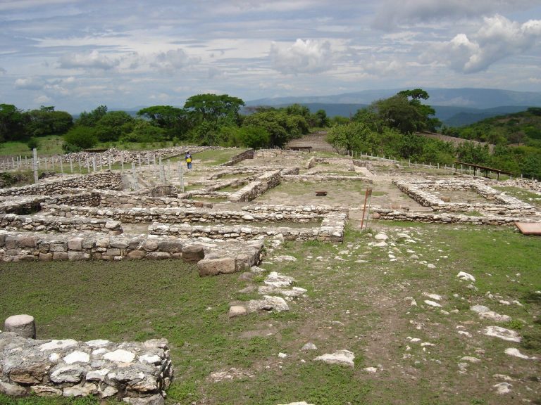
The archaeological area covers about 1.6–2 square kilometres on a level plateau roughly 600 metres above sea level, in the Amacuzac–Mezcala river region. A steep hill rises about 200 metres above the site. Its remains include monumental complexes, plazas, ballcourts, waterworks, agricultural terraces, and residential zones. Many houses had stone foundations supporting buildings made with perishable materials.
Groups and residential compounds
The site includes Groups A, B, and C, together with the Lomeríos residential zone. Group A lies about 1.5 kilometres southwest of Group C, on the southwestern slope beside Group B. Group B’s buildings follow an axis 18 degrees west of north on level ground northeast of León Hill. Group C contains two large buildings, smaller structures, a plaza, and two ballcourts.
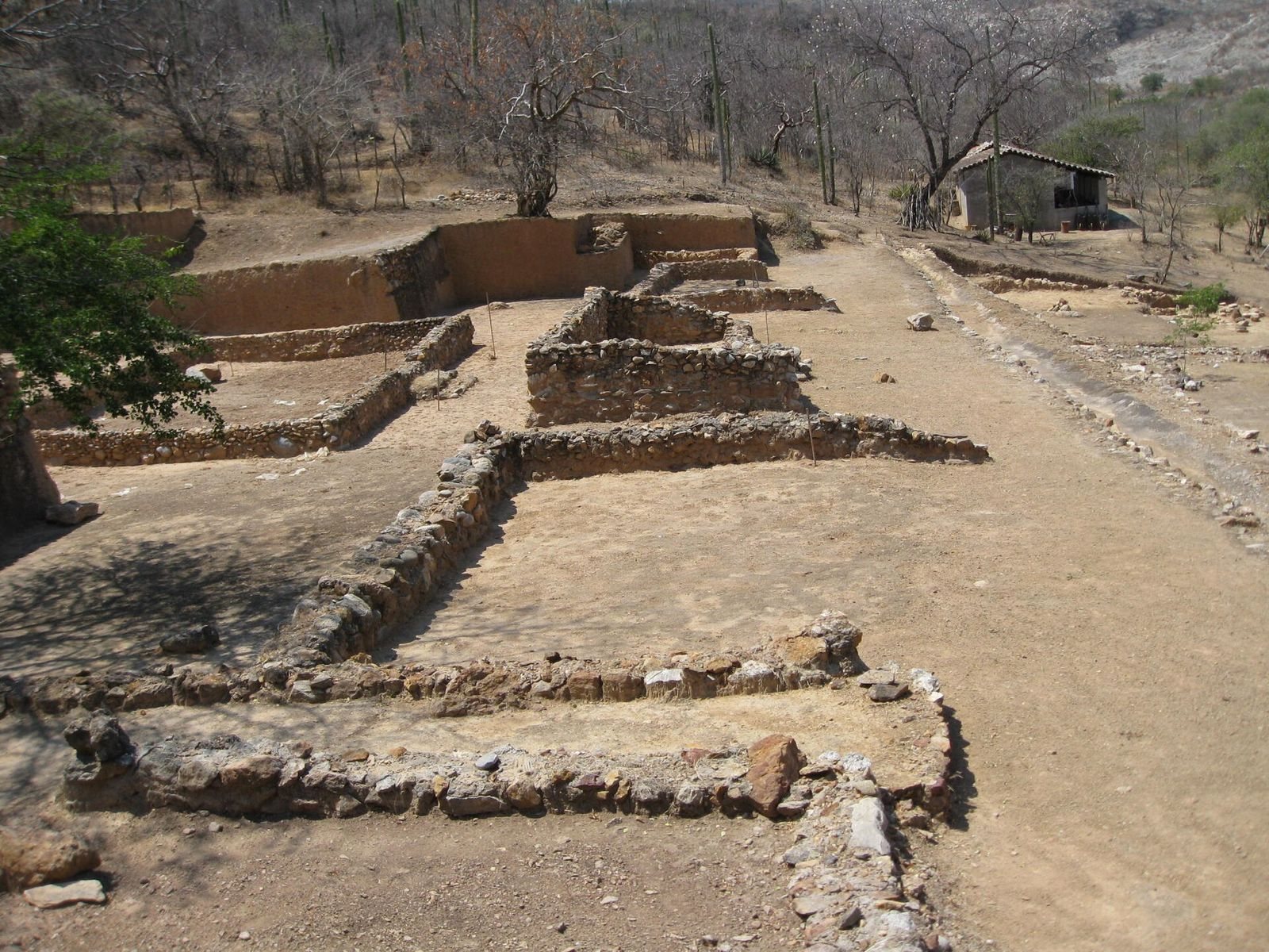
Residential compounds generally gathered several buildings, often four, around a shared courtyard or plaza. Excavated house S5 had stone wall foundations; house S6 had foundations of rock and cobbles with adobe walls. Outdoor hearths, work areas, storage places, burials, and refuse pits lay around the houses. The pits were bell-shaped, and those at S5 contained abundant dog remains alongside Balsas catfish, other freshwater animals, crabs, rabbits, young red deer, and white-tailed deer. These finds point to animal foods, while pollen analysis indicates that maize was also eaten.
Monumental architecture
El Recinto and the sunken court
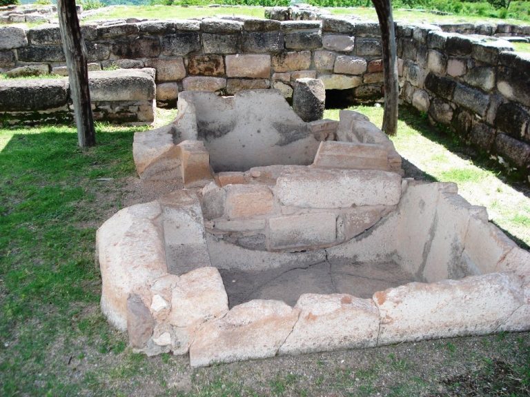
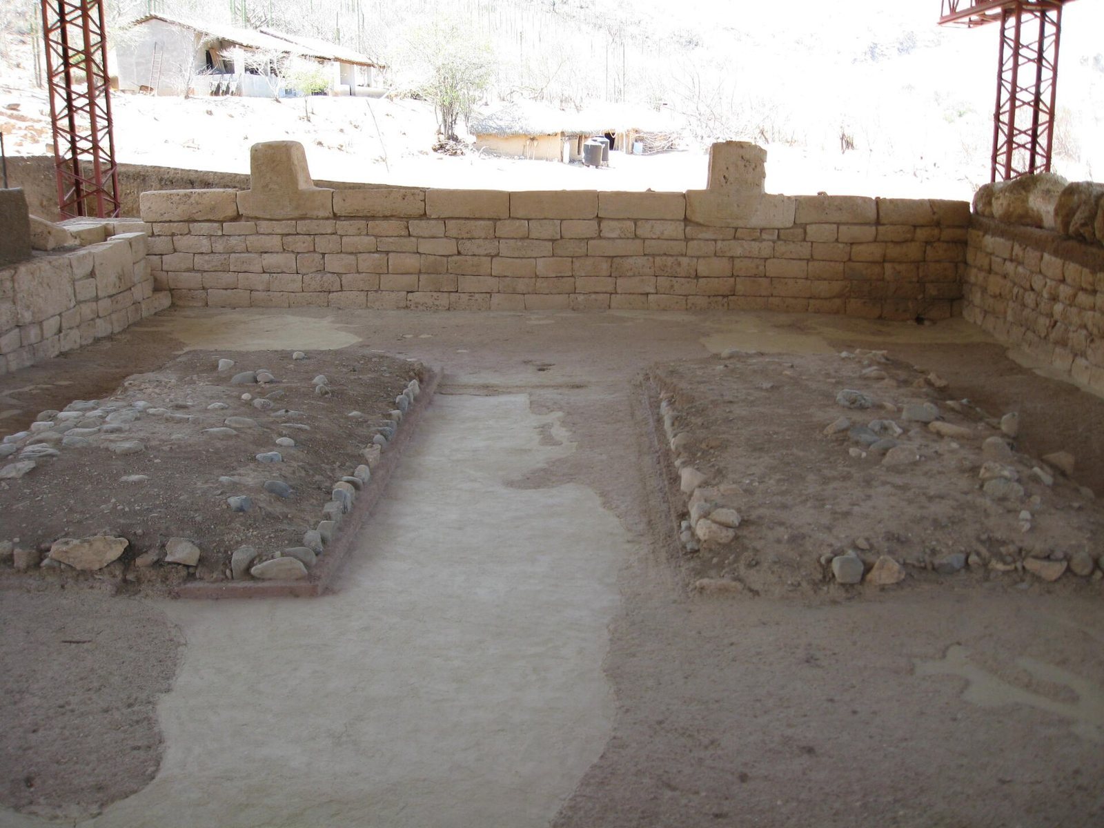
El Recinto, also called the Sunken Patio, is a monumental complex in the Group A area. Its court lies about two metres below the surrounding ground and is enclosed by a surrounding structure. In Phase I, an earthen building measuring about 26 by 32 metres and standing 1.2 metres high had a surface of yellowish clay and compacted earth. The interior court was altered in Phase II, and the building’s southern stairway was shaped to suggest the face of a jaguar deity.
In Phase II, limestone blocks covered the earlier earthen structure. Limestone also lined grooves in its floor. The court measured about 18.6 by 14.2 metres and was enclosed by a corridor-like structure. A paired stairway on the south side descended to the east and west. Feline deity heads, probably representing jaguars, decorated the stairway’s side supports, along with a motif described as a “flaming brow.”
Carved stones and court structures
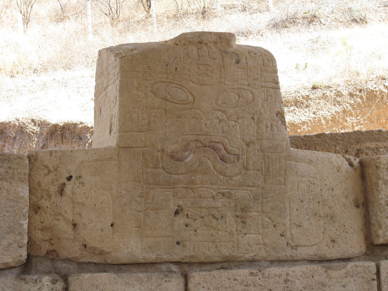
Four monumental stones stood at the court’s northeast, northwest, southeast, and southwest corners. Each was an inverted-T shape, made of travertine, a limestone deposited by mineral-rich water, and estimated to weigh 3–5 tonnes. Red pigment containing cinnabar coated the stones. Their carvings show stylized human-like faces, probably jaguar-like, with downturned mouths, fangs, almond- or teardrop-shaped eyes, and an X-shaped chest emblem. The figures hold forms resembling torches or plants.
The arrangement of Monuments 2 and 4 places their shadows at the court’s centre at sunrise and sunset on the spring equinox. Martínez Donjuán interpreted the stones as markers of equinoxes or solstices and as symbols of opposing forces governing the world. She also read symbols on the back of Monument 2 as “10 Flower,” a calendrical designation combining a number and a day sign. If that reading is correct, it would be the earliest known Mesoamerican calendar date. Two small, parallel structures inside the court, each about 7 by 3 metres, are thought to have formed a ballcourt.
Phase III terrace and burials
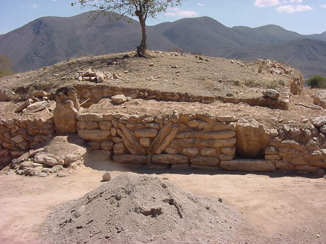
During Phase III, the centre of El Recinto became a terrace that reused the earlier building’s walls. The complex was extended 6 by 55 metres to the north, and reliefs decorated the terrace wall. Uncarved, block-like upright stones stood to the east and west, each with a carved frog sculpture or altar in front. Sculpted human heads were attached to the wall. The arrangement of upright stones and frog altars has been compared with practices at Izapa and later Classic Maya sites; the human-head sculptures have also been interpreted as evidence of connections with Izapa and the Guatemalan highlands.
Burials lay north and south of the western upright stone. They included one adult and four children. A pottery vessel accompanied the adult, while the children had geometric mother-of-pearl ornaments. A nearby dog burial had similar ornaments, and remains of two carnivores lay beside one child burial.
Buildings and ballcourts
Building 3, north of El Recinto, was constructed of flat stones in Phase II. Its Phase III successor, east of the terrace extension, measured about 24.6 by 19.5 metres and stood up to 2.5 metres high. It covered the earlier building and part of a canal connected with the dam; some large blocks may have been taken from the canal. Its stonework includes V-shaped arrangements of blocks and rounded stones, as well as a niche about 6 by 30 centimetres. Building 3 was paired with Building 2 in a ballcourt.
A separate ballcourt about 78.3 metres long was built roughly 900 metres north of El Recinto during Phase III. The site also has the two ballcourts in Group C. In Phase III, two pyramid-like structures were built near the large irrigation canal, using stone blocks unlike those of Phase II. Some blocks have rod-shaped and spotted or circular forms, while others form double-V patterns. These designs have been interpreted as references to rattlesnakes and to the symbolism of earth and water.
Water management and agriculture
Dam and canal
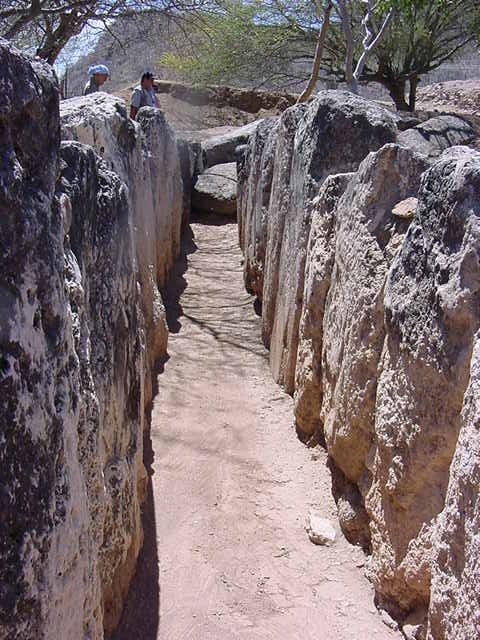
A dam-like structure in a valley west of Group A was built in Phase II to collect spring water and runoff from the mountains. A covered canal about 100 metres long connected with it. The canal was built of limestone blocks roughly 1.2–1.9 metres high, 50–75 centimetres wide, and 20–40 centimetres thick. Its channel measured 70–90 centimetres across and 0.9–1.5 metres deep. Irrigation of farmland was a proposed use; stone-lined canals also helped control erosion and water loss and could serve drainage or sewer functions. A nearby tomb had a burial chamber built with a corbelled vault, formed by overlapping successive courses of masonry. This technique, used in tombs and temples, represents one of the earliest known examples of its use in Mesoamerica.
Agricultural terraces
Agricultural terraces are among the remains at Teopantecuanitlan, forming part of the site’s evidence for the management and use of its surrounding land.
Objects and activities in residential areas
Household tools, pottery, and figurines
Finds from Lomeríos include notched stone weights thought to have been used for fishing, clay discs that served as spindle whorls, or weighted tools for spinning fibers, and rectangular metates, grinding stones used with hand-held grinding stones called manos. Plain pottery included cooking plates, jars, and bowls. Other vessels carry incised “split-hand” designs, painted or incised decoration, or a pale surface coating. Some molded cylindrical vessels combine human, feline, and reptilian forms associated with Olmec religious imagery.
Many hollow clay figures depict plump infants. Solid examples include painted figures wearing turban-like or forward-hanging headdresses. Some infant-faced figures show cranial deformation and shaved heads with hair left at the back. Clay sculptures recovered north of the Sunken Patio are considered the oldest sculptures at the site and have been compared with monuments at Ojo de Agua in Chiapas, dated to 1200–1100 BCE.
Shell, ornaments, and mirrors
House S5 yielded thin, spool-shaped earrings made from banded agate and Guerrero serpentinite, numerous small mica discs, and mirrors made from iron ore. Other shell finds include orange beads of thorny oyster shell and bracelets made from pearl-oyster shell and large marine shells. At least eight kinds of Pacific shell were recovered, with 78 percent of the shell identified as pearl oyster, Pinctada mazatlanica. Concentrations of fragments and trimmings at S5 indicate that shell was worked there. Animal-shaped and geometric mother-of-pearl ornaments came chiefly from El Recinto’s ritual structures and also accompanied child and dog burials.
Obsidian and evidence of exchange
Obsidian from residential buildings was mainly banded grey and black, with little green obsidian, a pattern suggesting that most came from Otumba rather than Pachuca. Blades with triangular cross-sections made up 75 percent of obsidian pieces recovered from house structures and were concentrated in two locations. This distribution suggests that cores arrived through trade and were worked in residential workshops, although the workshops’ precise locations are unknown. Olmec-style or Olmec-influenced pottery, imported shell and obsidian, and artifacts of the Mezcala tradition, an archaeological tradition of Guerrero known for distinctive stone sculpture, were also found in and around residential compounds.