Takaosan Kofun: An Early Front-Square, Rear-Square Burial Mound in Japan


Site at a Glance
- Rating
- 3.6
- Popularity
- Very Low
- Country
- Japan
- Primary era
- Classical
- External website
- Open
- Eras represented
- Classical
- Civilizations
- Unclassified
- Site type
- Burial
- Remains
- Burial Mound
On this page11 sections
History
Takaosan Kofun is an early Kofun-period burial mound in Numazu, Japan, built around AD 250 in the transitional era when large elite tombs and new political practices emerged alongside older Yayoi traditions. Its front-square, rear-square design, substantial size and varied burial goods make it an important site for understanding the formation of kofun culture and the development of early states in the Japanese archipelago.
Formation in the early Kofun period
Numazu City’s education authorities date both construction and burial to around AD 250. An earlier interpretation placed construction around AD 230 and burial around AD 250, based on pottery found in the mound. That interpretation later treated much of the earlier pottery as material from an older settlement that had been incorporated into the mound and its ditch during construction. The difference reflects the complicated history of the site’s deposits rather than two separate building phases.
Takaosan Kofun developed within a connected regional landscape extending from the Ashitaka foothills to Ukishima Lagoon, the Kano River and the Tagata Plain. The Ashitaka-Oue settlement group continued from the late Yayoi period into the beginning of the Kofun period and included dwellings, cultivated land, burial areas and a large V-shaped ditch cut across a ridge. Its organized layout and chronological overlap with the mound have led to the view that it may have contributed directly or indirectly to the construction, although the exact relationship remains uncertain. The Irikata site immediately west of the mound has also been proposed as the residence of the chiefly individual buried at Takaosan Kofun.
Pottery and the location of the mound point to extensive exchange. Local eastern-Shizuoka vessels predominate, but pottery from Hokuriku, Omi, western Tokai and the Kanto region was also present. Connections extended toward western Tokai, inland routes beyond the Fuji River and other areas of central and eastern Japan. The nearby lagoon probably permitted boat travel, helping to connect the lower Kano River region with maritime networks.
A regional center of power
The mound has been interpreted as the work of a regional leader who controlled or participated in these networks. Its size and construction suggest organized labor and authority, while its burial assemblage combines objects associated with older Yayoi customs and weapons and practices linked to early kofun. This combination places Takaosan Kofun within the emergence phase of the Kofun period, when established regional traditions coexisted with new forms of elite burial.
The identity of the buried person remains a matter of interpretation. Suggestions have included a member of the Mononobe lineage, a ruler of Kunu, and a strongly martial regional leader. Kunu was one of the polities mentioned in the third-century Chinese historical tradition known as the Record of the Wa in the Wei Chronicle, which describes conflict between Kunu and Yamatai. The proposed connection between the tomb and Kunu is not established, although the lack of Kinai-style pottery has been used to support it.
The relationship between Takaosan Kofun and the emerging Yamato kingship is similarly disputed. The Yamato kingship was a developing central authority based in the Kinai region during the early Kofun period. Some interpretations see the mound’s weapons and ornaments as evidence of early Yamato involvement or expansion toward the east. Others propose limited or indirect influence, or emphasize political networks that developed locally rather than under the direct control of Yamato or western Tokai powers.
Shrines, recognition and preservation
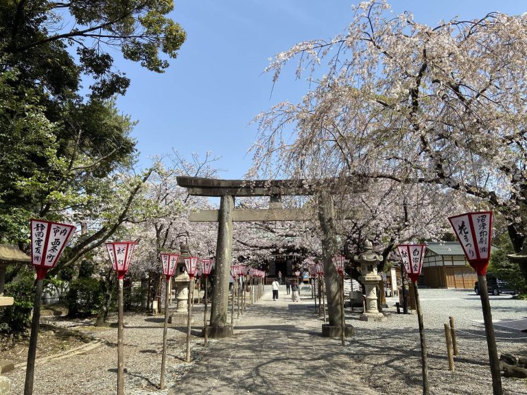
The mound was long associated with two shrines. Kumano Shrine occupied the former front section, while Takaosan Homi Shrine stood on the rear section. Takaosan Homi Shrine was founded in 1846 after seven residents of Higashikumando requested that a divided spirit be enshrined from a shrine in present-day Minami-Alps. Its popularity led to relocation into the Kumano Shrine precinct in 1888. Kumano Shrine’s foundation date is unknown, but an account from 1570 records its longstanding local importance. During the Edo period it received shrine lands, became a village shrine in 1875 and was renovated with tiled roofing in 1923.
The site first attracted archaeological attention when the square raised ground beneath Takaosan Homi Shrine was recognized as a possible ancient mound. Shinichi Ono, who worked at the Kato Gakuen Archaeological Research Institute, introduced the name Takaosan Kofun in a 1978 history of Numazu, although he initially understood the site to be a square mound. Numazu City later registered it under an earlier name derived from a nearby place-name before adopting Takaosan Kofun as its official name in 2011.
Trial excavations in fiscal year 2005 identified a surrounding ditch and Haji pottery, an unglazed earthenware made in ancient Japan. A second trial excavation followed in 2007, and full investigations took place in fiscal years 2008 and 2009. The burial facility was excavated, but a planned investigation involving the removal of part of the mound was halted during a dispute over preservation. Further investigation in fiscal year 2014 made the existence of additional burial facilities less likely.
Preservation became urgent when the planned Numazu Minami-Isshiki urban-planning road threatened the mound in the 2000s and 2010s. Numazu initially planned to record the archaeological evidence while allowing the road to proceed, but academic evaluation, public debate and preservation appeals led the city to withdraw its dismantling policy in August 2015. An advisory council met in 2015 and 2016 and examined nine alternatives, including rerouting, tunnels, divided carriageways and a T-junction. Relocating the mound was rejected because its rammed-earth construction had no domestic precedent for relocation and its original setting was part of its value.
A proposed four-lane road with a T-junction west of the mound was abandoned after the Shizuoka Prefectural Public Safety Commission raised concerns about large vehicles negotiating the bend. In December 2017, the city adopted a plan placing the western carriageway in a tunnel beneath the mound and the eastern carriageway on a bridge between the mound and the two shrines. A 2018 basic plan sought to treat the road and mound as an integrated landscape. After a design competition held after 2019, a proposal was selected in February 2020 that avoided damage to the mound and prevented heavy machinery from being placed on it during construction. The shrines were relocated to adjoining land east of the mound, with the ceremony completed in September 2009. In December 2022, Numazu requested designation as a historic site. The Cultural Affairs Council recommended designation in June 2024, and Takaosan Kofun became a National Historic Site on October 11, 2024.
Remains
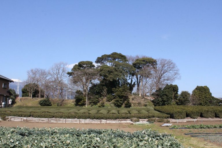
Takaosan Kofun stands at about 20 metres above sea level at the terminal end of a ridge extending from Mount Ashitaka. It occupies the end of a low hill rather than a high summit. The original mound was approximately 62.18 metres long and consisted of a square rear section with a projecting square front section directed south. The rear part is broadly trapezoidal, while the front widens toward the south in a fan-shaped or spatulate form. Its nearly equal length to the rear section is an important characteristic of the mound’s early design.
Mound and surrounding ditch
The rear section measures about 31.77 metres in length, with an estimated north side of 29.18 metres and south side of 35.7 metres. Its corners are rounded. The surviving rear mound rises just over 4 metres, while its original height was probably close to 5 metres. The front section was about 30.77 metres long. Its upper part was reduced when the Kumano Shrine precinct was created, leaving limited direct evidence for the way it was originally built.
A ditch generally 8 to 9 metres wide surrounded the mound. Along the southern face of the front section it narrowed to approximately 2.5 to 3.2 metres, and a gap about 6.4 metres wide in the southeast formed an earthen bridge. A further east-west ditch, roughly 1 metre wide and located about 4 metres south of the southern ditch, may have supplemented the bridge, although its western continuation has not been confirmed. The mound’s west side was cut away by a municipal road, and its rear section was reduced by a shrine retaining wall. Several air-raid shelters were also dug into the mound. The estimated original area was about 3,030 square metres, with approximately 2,200 square metres still visible in plan.
Large-scale cutting reduced the hill before or during construction. The excavated soil may have supplied earth for the mound while creating a broad, level setting for its form. The maximum depth of cutting is estimated at about 2 metres, a treatment not confirmed at other kofun from this early stage. The rear section was placed directly over newly deposited scoria dating from the end of the Yayoi period to the beginning of the Kofun period. It was probably built mainly by adding earth, while soil from the hill and ditch was mixed with darker, more cohesive material because the loose scoria-rich loam could collapse.
The mound used rammed-earth construction, in which soil was laid in successive layers and compacted. Evidence from the burial facility and pottery indicates that approximately 50 centimetres of the upper mound was removed at a later stage, accounting for the difference between its surviving and estimated original heights. Archaeological interpretations differ over the original plan. One compares it with the circular planning of early front-round, rear-round mounds, while another reconstructs a square system and notes formal similarities with Funami Kofun in Shiga and Kai Choshizuka Kofun in Yamanashi. The developed front section and incomplete ditch have been interpreted both as signs of an early standardized form and as survivals of an earlier design.
Burial facility
The principal burial facility lies at the center of the rear section. Its nearly rectangular pit measures approximately 4.955 metres along the east side, 6.135 metres along the south side, 4.431 metres along the west side and 5.923 metres along the north side. The pit’s long axis runs east to west, at right angles to the mound’s north-south axis, and its walls slope gradually toward the coffin bed.
Boat-shaped coffin
The deceased was placed directly in a wooden coffin. Wood fragments and traces of grain indicate a coffin about 5.053 metres long and up to 1.252 metres wide. It was probably shaped like a dugout boat, either made from a hollowed log or from a hollowed base with additional side boards. This is among the earliest coffin examples known in Shizuoka and has been connected with coffin traditions along the northern Japan Sea coast.
The body probably lay with the head toward the east and the feet toward the west. Red pigment surrounded the head, chest and feet, with small traces across the coffin floor. Chemical analysis identified the pigment as mercury sulfide, or cinnabar. A small jar cut vertically through its body also contained cinnabar and may have held the pigment during the burial.
Mirror and weapons
A deliberately broken bronze mirror was recovered in ten fragments, although some pieces were not found. Three fragments may have been placed on the coffin lid. The mirror was approximately 13.5 centimetres in diameter and is classified as a six-image, raised-relief beast-and-immortal mirror of the Shangfangzuo type. Its reconstructed inscriptions mean “Made in Shangfang” and “May it benefit sons and grandsons.” Deer, tiger, bird and feathered immortal figures appear in relief. Production dates to the late second century, while its precise origin remains debated between China and the Lelang region.
Two iron weapons accompanied the burial. The larger was 45.5 centimetres long, with a 41.1-centimetre blade and a 4.4-centimetre tang. It lay near the feet with its point facing west. X-ray examination revealed a forged weapon with an unusually grooved blade. Three holes in the tang suggest that it began as an iron sword and was later converted into a spear. The smaller weapon measured about 23.2 centimetres overall, with a 12.6-centimetre blade and a 10.6-centimetre tang. Its form has led some interpretations to identify it as an iron sword rather than a spear.
Red lacquer and woven material show that at least one spear had a lacquered wooden shaft wrapped in cloth. Four groups of lacquer film were identified, and one reconstructed shaft may have been about 1.4 metres long. Thirty-two iron arrowheads were also recovered, including willow-leaf forms, triangular forms with notched bases and a long triangular example with a forged tang-fitting component. Most lay beside the right foot, while others were near the head and right shoulder.
Tool and magatama
An iron yari-kanna, an early woodworking tool with a narrow spear-like blade, lay above the presumed head area. It is 12 centimetres long and has a spoon-shaped blade 2.5 centimetres long, 0.9 centimetres wide and 0.15 centimetres thick. Its shaft was set into a groove in a wooden handle, bound with thread and fixed with lacquer. The surviving handle measures approximately 9.4 by 1.3 by 0.8 centimetres.
A single small magatama, a curved bead used as an ornament or ritual object, lay near the center of the coffin in the area interpreted as the chest. It measures approximately 1.25 centimetres along its longer axis and 0.95 centimetres along its shorter axis. The excavation report identifies its material as hornfels or siliceous shale, while another interpretation proposes steatite. Cinnabar traces suggest that the bead was coated, and its position may indicate that it was worn around the neck.
Pottery and later occupation
Large quantities of pottery came from the mound summit, surrounding ditch and mound fill. The vessels include small jars, small bowls and straight-necked jars associated with funerary activity, together with double-rimmed jars, large jars, high-footed vessels, palace-style jars and S-shaped jars. Eastern-Shizuoka pottery dominates the assemblage, but vessels from Hokuriku, Omi, western Tokai and the Kanto region demonstrate connections across the Pacific side of central and eastern Japan.
The regional Ooguro pottery tradition appears in four forms that span its development from approximately AD 200 to 300. Form 1 pottery in the mound fill once supported a construction date around AD 230, while form 3 vessels above the burial facility, including a double-rimmed jar and a large jar, were associated with burial around AD 250. Ooguro pottery developed from eastern-Shizuoka forms influenced by imported vessels and was probably made mainly in the lower Kano River basin. Its large jars are unusually light because their clay contains Kawagodaira pumice.
Three dwellings from the Ritsuryo period were identified within the kofun’s area, and a depression in the ditch may represent another. Along with late Ritsuryo pottery concentrated near the junction of the front and rear sections, these remains indicate that at least five dwellings occupied the mound’s area after its construction. Later deposits include ceramics and whetstones dating from the late Edo period through the period after the late Taisho era, adding further phases to the site’s physical history.