Slawenburg Raddusch: A Reconstructed Slavic Refuge Fortification in Germany



Site at a Glance
- Rating
- 4.2
- Popularity
- Medium
- Country
- Germany
- Primary era
- Medieval
- Eras represented
- Medieval, Modern
- Civilizations
- German
- Site type
- Military
- Remains
- Fort
On this page14 sections
History
Slawenburg Raddusch in Germany is a largely faithful modern reconstruction of a Slavic refuge fortification established around 880 by the Lusitzi, a West Slavic tribal group, near present-day Raddusch in Lower Lusatia. The original early medieval fort formed part of a regional network of about 40 circular ramparts built during the ninth and tenth centuries, when communities faced growing pressure from the Saxon side.
Early settlement and Slavic construction
The fort stood on a slight elevation and was substantially renewed around 930. At that time, its rampart was widened and raised, and further repairs were carried out before 950 as pressure from the East Frankish Kingdom increased. This early medieval kingdom occupied the eastern part of the Carolingian realm and preceded the medieval German kingdom. Because its timber framework was vulnerable to decay and slippage, the rampart needed renewal roughly every 40 to 50 years.
The elevation had been occupied before the Slavic fort was built. Pottery associated with the Lusatian culture, a prehistoric culture of Central Europe dating to the Late Bronze Age and Early Iron Age, indicates settlement after 700 BC. Beneath the Slavic rampart, excavators also found material from the Migration Period, the era of major population movements and political change between late antiquity and the early Middle Ages. These finds, dating to the fifth or sixth century, included pottery sherds, miniature vessels, brooch fragments, and beads. Later construction altered the earlier layers of the site.
Saxon expansion and abandonment
The fort’s later history unfolded during the campaigns of Henry I, the German king who ruled from 919 to 936. In 929, during his Slavic campaigns, Henry founded the fortress of Meissen. The Lusitzi became tributary in 932. In 963, the Saxon margrave Gero, a frontier governor and military commander, subjugated the Lusitzi. The Raddusch fort was then abandoned and gradually decayed.
Rudolf Virchow, a German physician and pathologist whose work also included archaeology and anthropology, mentioned the site as a Slavic rampart fortification in 1880. During the twentieth century, the fort remained visible as a tree-covered circular elevation. Agricultural cultivation continued until 1984 and substantially levelled the earthwork, leaving a mound about 3 metres high and 85 metres in diameter.
Rescue excavation and reconstruction
Planned lignite mining at the Seese-Ost open-cast mine threatened the archaeological site. From 1984 to 1990, archaeologists of the Central Institute for Ancient History and Archaeology of the Academy of Sciences of the German Democratic Republic carried out a rescue excavation. Their work almost completely documented the fort and recovered an approximately 1,100-year-old wooden idol.
After the Lübbenau and Vetschau power stations were shut down after 1990, lignite extraction ended. The mine stopped a few hundred metres from the archaeological monument. The Brandenburg State Office for Monument Protection and Archaeology and the Archaeological State Museum subsequently decided to rebuild the fort at its historical location, using mining-land restoration funds. The reconstruction represents the many cultural monuments that were lost to lignite mining in the region.
Construction took place between 1999 and 2003. Excavation established the forms, construction methods, and dimensions of the rampart, ditch, and gates, while some additional details were informed by excavated fortifications elsewhere in Lower Lusatia. The complex also contained a permanent exhibition on about 12,000 years of settlement history in Lower Lusatia, from the Stone Age to the Middle Ages, together with a museum, restaurant, and conference room.
Recent institutional history
From August 2024, the complex was operated by Slawenburg gGmbH of the Stiftung Slavonic Europe, a foundation established by Czech investor David Chmelík. It had previously belonged to the Regional Development Corporation of Vetschau. The city of Vetschau terminated the lease on 4 December 2025 after continuing disagreements. A planned handover on 8 January 2026 did not take place because the tenant objected to the termination. Insolvency proceedings against Slawenburg gGmbH began in February 2026. Operations then ceased, and the exhibition was dismantled and returned to its lenders.
Remains
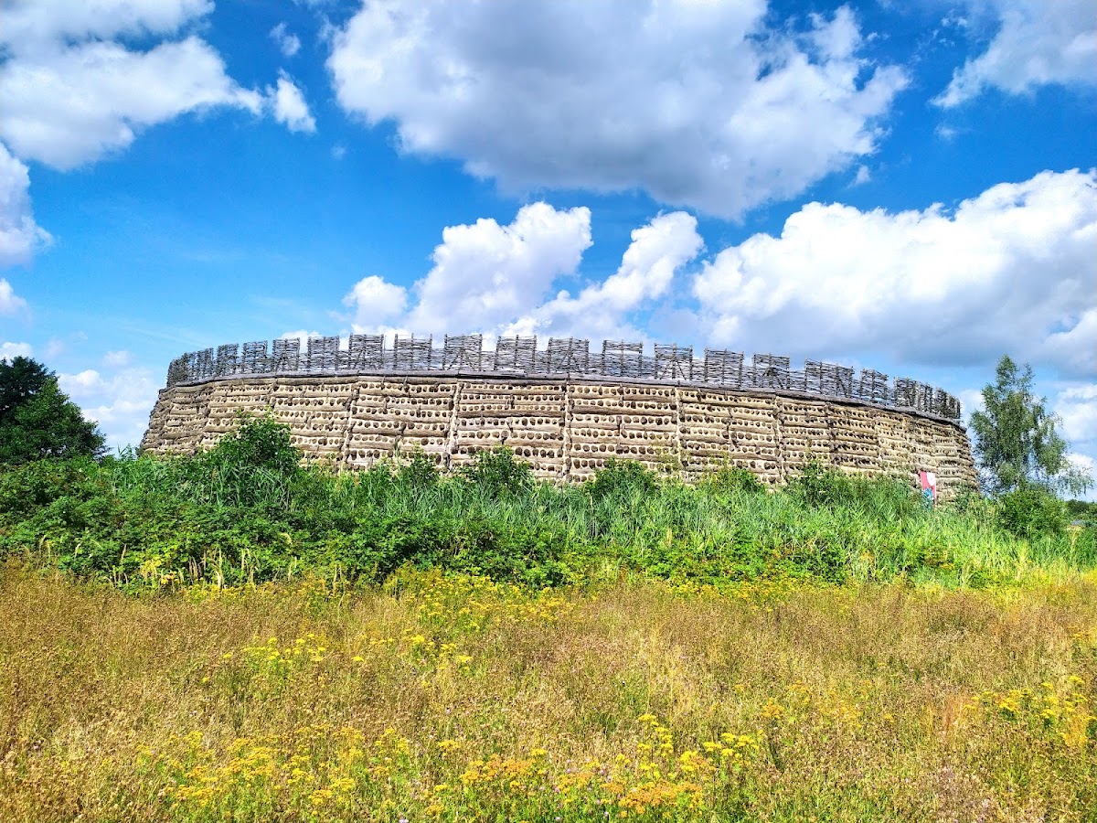
The reconstructed fort follows the nearly circular plan revealed by excavation. Its main elements are an enclosed courtyard, a broad timber-and-earth rampart, an external ditch, and two entrances. The original fort’s first interior measured about 35 to 36 metres across. During a later building phase, the rampart reached about 20 metres in width and the enclosed area was reduced to roughly 28 metres in diameter.
Rampart, ditch, and entrances
Timber-and-earth rampart
The first rampart was about 10 metres wide. Long oak beams were laid alternately lengthwise and crosswise, creating a wooden lattice whose spaces were packed with earth and stones. This timber-and-earth construction produced a strong defensive bank, but its wooden framework required periodic renewal because of decay and movement. The modern rampart reproduces the excavated outer form and dimensions. Its timber-and-earth appearance, however, is applied as an exterior facing over a hollow concrete structure.
Ditch and gates
A flat-bottomed ditch about 5.5 metres wide surrounded the rampart. Two gate tunnels passed through it, one on the northwestern side toward the outer settlement and another on the eastern side. This arrangement was unusual for a fortification of such a small size. Bridges probably crossed the ditch beyond the entrances, while ramps led to the gate tunnels during the later phase. A path about 2.3 metres wide connected the two entrances across the courtyard.
Courtyard buildings and wells
Interior buildings
Houses occupied the inner area of the original fort. Some had clay floors, while others contained dome-shaped ovens. The reconstructed courtyard covers approximately 1,000 square metres. It contains reconstructed storage buildings and a reconstructed well, while the hollow interior of the modern rampart was designed to accommodate the museum and restaurant.
Wells and waterlogged finds
Four box-built wells were identified inside the fort. Dendrochronology, the dating of wood through annual tree-ring sequences, placed the timber of the oldest well around 880. The youngest well belonged to the final fortification phase. It was about 12 metres deep and consisted of six timber boxes that narrowed successively, an arrangement described as unique in the West Slavic region.
The wells contained ceramic fragments, knives, spearheads, whetstones, bone skates, wooden mallets, and spades. A rare brass bowl known as a Hanseatic bowl dates to after 950. These objects provide material evidence for activity within the fort during its successive phases.
The Idol of Raddusch
The youngest well also contained the Idol of Raddusch, an oak plank split from a log. Its upper end was shaped roughly like a head, and a perforation pierced the chest area. Dendrochronology dates the wood to 926. The idol was erected during construction of the second fort and later damaged by axe marks and traces of fire before being placed in the construction pit of the youngest well. Its original position within the fort is unknown.
This form of wooden idol is unique. A broadly comparable oak plank with an incised face was found at Ralswiek on Rügen. The closest parallels are 63 head-shaped planks discovered at the reconstructed Slavic fort of Groß Raden, where they formed a decorative wall in a cult hall.
Reconstructed setting
Slawenburg Raddusch stands near the village of Raddusch in Lower Lusatia, close to Vetschau and the former Seese-Ost mining area. The former open-cast mine is now Bischdorf Lake, while excavation stopped a few hundred metres from the monument. A similar nearby fortification, Slawenburg Tornow, may have been established as early as the seventh century and enclosed an area about 25 metres in diameter.