Seoul Seokchon-dong Gobungun: A Baekje Royal and Aristocratic Cemetery
Site at a Glance
- Rating
- 4.5
- Popularity
- Low
- Country
- South Korea
- Primary era
- Classical
- External website
- Open
- Eras represented
- Classical
- Civilizations
- Baekje
- Site type
- Burial
- Remains
- Necropolis
On this page16 sections
History
Seoul Seokchon-dong Gobungun is a Baekje-period cemetery in Songpa District, Seoul, South Korea, built during the era when Baekje’s political centre was at Hanseong in the Seoul area. The cemetery is generally understood as a burial ground for members of the early Baekje royal and aristocratic elite. Its stone-mound tombs combine stepped forms associated with Goguryeo, the northern Korean kingdom, with construction practices identified as Baekje-style.
The Hanseong-period cemetery
The cemetery occupied the south bank of the Han River near the fortified sites of Pungnaptoseong and Mongchontoseong, both associated with the early Baekje capital region. Its graves included stone-mound tombs, earthen mounds, pit graves, wooden-chamber graves, jar burials, and stone-coffin graves. Pottery, roof-end tiles, gold earrings, and ceramics from the Eastern Jin, a Chinese dynasty that ruled from 317 to 420, indicate connections between Baekje and contemporary Chinese states.
The large stepped tombs resemble developed Goguryeo stone-mound tombs, which were built with substantial stone platforms and tiers. Their internal construction differs, however, and this combination has led to the term “Baekje-style stone-mound tombs.” The form has also been associated with traditions that Baekje’s founding population moved south from Goguryeo territory, although the archaeological and documentary chronologies do not fully coincide.
Changing extent and modern destruction
Early twentieth-century investigations produced different estimates of the cemetery’s former size. An investigation in 1916 counted more than 90 stone-mound and earthen burial mounds, while a map from 1917 indicated approximately 290 graves. A prewar survey counted 66 stone mounds and 23 earthen mounds.
After Korea’s liberation and into the early 1960s, warfare, disorder, and uncontrolled settlement caused extensive damage. Unauthorized houses were built over the graves. Urban development during the 1970s and 1980s destroyed more than 99 percent of the archaeological remains, leaving the western part of the cemetery and eight surviving mounds.
The site was threatened with burial during the Jamsil development project, prompting emergency archaeological work. The National Museum investigated the cemetery from 1971 to 1975, and the Seoul National University Museum carried out investigations in 1974, 1983, 1984, 1986, and 1987. A 1974 excavation led by Kim Won-yong examined Tombs 3 and 4 and established structural and construction similarities between the cemetery’s stone-mound tombs and Goguryeo examples near present-day Huanren.
Protection and continuing investigation
In 1975 the cemetery became Korean Historic Site No. 243 under the name “Seokchon-dong Early Baekje Stone-Mound Tombs.” Its official name changed to Seoul Seokchon-dong Gobungun in 2011.
A road project in 1983 cut into part of Tomb 3’s basal platform. Reexamination of the tomb and its surroundings identified more than 30 graves, including seven large stone-mound tombs, pit graves, and jar burials. The protected area was consequently enlarged from 1,513 pyeong to 4,928 pyeong. In 1985, a preservation order covering Baekje remains in southern Seoul included Seokchon-dong, the Bangi-dong cemeteries, and Mongchontoseong. The Seokchon-dong protected area, regarded as a possible Baekje royal cemetery, was expanded to approximately 17,000 pyeong. Nearby houses were removed in 1987, enabling wider investigation and the creation of Baekje Ancient Tombs Park.
A sinkhole in 2015 led to further archaeological investigation. Work reported in 2020 identified connected stone-mound tombs formed from adjoining units, wooden-chamber graves beneath stone mounds, and cremated human remains reduced to bone fragments. The relationship between the pit graves and stone mounds is chronological as well as physical, since the pit graves lay beneath the mound bases.
Proposed royal associations
Tomb 3 is conventionally regarded as a royal tomb from the late fourth century. Its scale and date have prompted proposed identifications with King Geunchogo or King Geungusu, fourth-century rulers of Baekje, but neither attribution is certain.
Tomb 4 has sometimes been associated with King Biyu, a fifth-century Baekje king. This interpretation depends on a reading of a record from the reign of King Gaero, another fifth-century ruler, which describes the use of large stones to make an outer coffin for the burial of his father’s remains. The identification remains an interpretation rather than a securely established name for the tomb.
Remains
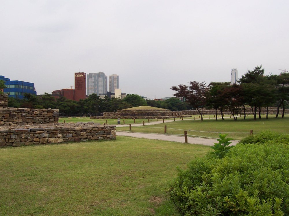
The protected site covers approximately 49,999 square metres. Its surviving layout is formed mainly by stone-mound tombs and earthen burial mounds, while excavations have also revealed earlier pit graves, wooden-chamber graves, jar burials, and stone-coffin graves. The principal stone mounds were constructed by stacking split stones and slab-like stones over a basal mound. Some were built almost entirely of stone, while others used stone platforms and steps around interiors filled with compacted earth.
Stone-mound tombs
Tomb 1
Tomb 1 survives chiefly as a basal structure and is interpreted as a double tomb formed from two adjoining mounds. The northern mound measures 9.9 metres from east to west and 8.9 metres from north to south. The southern mound measures 9.6 by 9.8 metres. Their western basal platforms were connected by a stone-built strip approximately 3.2 metres wide.
Four stone burial chambers were identified within the southern part of the tomb. Built with stones 20 to 30 centimetres long, they had floors covered with smaller stones and gravel. The largest chamber stood at the centre, aligned east to west, and measured approximately 2.5 by 2.3 metres. Three smaller chambers formed a row beside the northern stone wall. They measured approximately 1.8 by 1.2 metres, 1.6 by 1.4 metres, and 1.2 by 1.0 metres.
Tomb 2
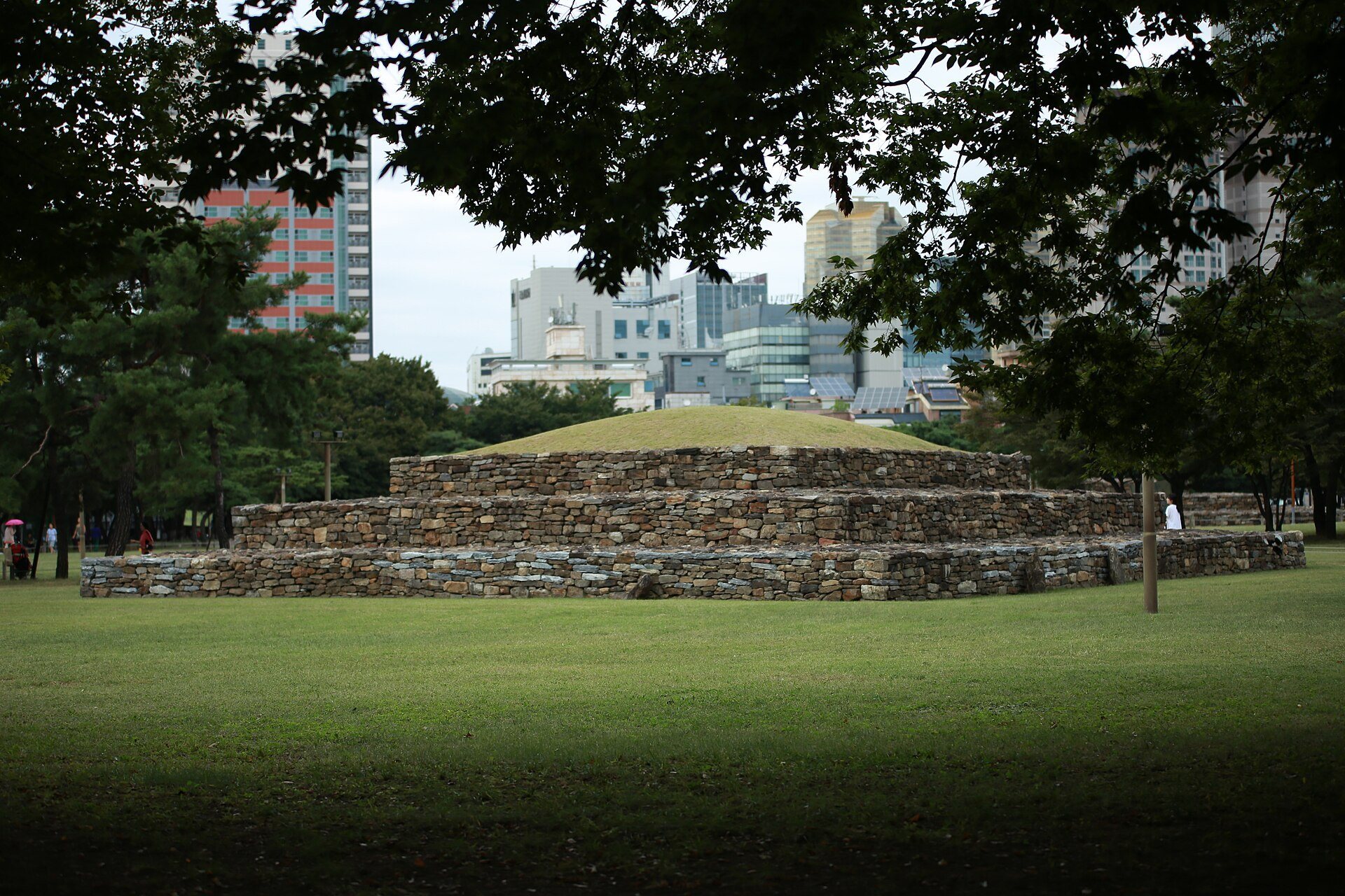
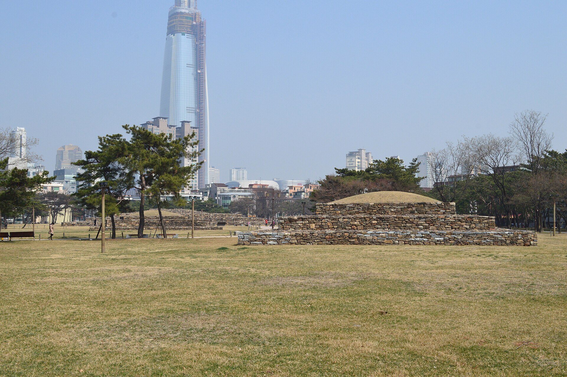
Tomb 2 originally formed a mound about 25 metres long, 20 metres wide, and 3 to 4 metres high. Before restoration, houses and a stone wall surrounded its base, and the damaged mound was covered by approximately 10 to 30 centimetres of earth. Its structure consisted of three stepped tiers. Each tier had an outer stone wall about 1 metre high, with compacted clay or earth inside and a rounded earthen surface above.
The restored first tier measures 16.4 metres east to west and 16.5 metres north to south. It is 90 centimetres high and has a 2-metre-wide step. The second tier measures 12.5 by 12.6 metres, is 0.9 metres high, and has a step of the same width. The third tier measures 8.5 by 8.6 metres, while the total mound reaches 3.5 metres. A wooden-chamber pit grave lay beneath the northwestern part of the first tier. It was aligned northeast to southwest and had an irregular narrowing plan, measuring approximately 2.5 metres in length.
Tomb 3
Tomb 3 is the cemetery’s largest mound, measuring 50.8 metres east to west, 48.4 metres north to south, and approximately 4.5 metres high. It is a square, stepped stone-mound tomb with at least three tiers and was built almost entirely of stone. Its late-fourth-century date and scale have contributed to its proposed association with King Geunchogo or King Geungusu.
Tomb 4
Tomb 4 follows the Baekje-style stone-mound form and measures approximately 17.2 metres in length. Its platforms and steps were built of stone, while the interior was filled with earth. The form has contributed to the proposed, though uncertain, identification of the tomb with King Biyu.
Tomb 5
Tomb 5 is a circular earthen mound approximately 17 metres in diameter and 3 metres high. Earth was compacted over the burial structure, followed by a layer of river stones and irregular stones, which was then covered with a thin layer of earth. This construction is known as a stone-covered earthen mound. The mound was only partly excavated because its burial form was unusually well preserved, leaving its internal structure unexamined.
Garak-dong Tombs 1 and 2 lay approximately 10 metres east of Tomb 5. Tomb 1 contained a wooden-coffin pit grave, while Tomb 2 contained both a wooden-coffin pit grave and a jar burial. These nearby structures provided a basis for the tentative interpretation that Tomb 5 also contained a wooden-coffin pit grave.
Inner-round, outer-square mound
A severely damaged stone-mound tomb preserved portions of its southwestern corner and its western and northern basal platforms. Reconstruction of the exposed base produced an inner circular plan approximately 11.4 metres in diameter within an outer square whose sides measured about 16 metres. Two stone-lined pit graves and three stone-coffin graves occupied the inner circular area, and the stone mound appears to have been built over these earlier burials.
This inner-round, outer-square arrangement resembles the form of certain Japanese kofun, whose upper plan is circular and lower plan square. The resemblance does not establish that the two forms shared an identical construction tradition.
Pit graves and earlier burials
Seokchon-dong Pit Grave 2
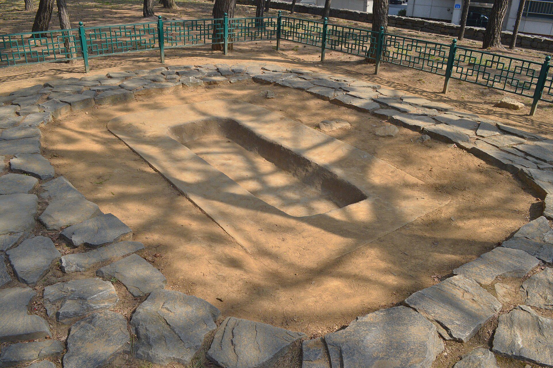
Seokchon-dong Pit Grave 2 was cut into natural soil and had a rectangular plan aligned southeast to northwest. It measured 223 centimetres long, 76 centimetres wide, and 21 centimetres deep. A grayish-white short-necked jar stood on the eastern side of the otherwise unfurnished floor. A plain gold earring, 1.6 to 1.7 centimetres in diameter, was found in the earth slightly above the floor.
Seokchon-dong Pit Grave 3
Seokchon-dong Pit Grave 3 lay 70 centimetres beneath the surface. It had a rectangular plan with rounded corners, vertical walls, and a northeast-to-southwest alignment. A gray-blue short-necked jar stood at the northwestern corner of the otherwise unfurnished floor. The grave measured 230 centimetres long, 84 centimetres wide, and 18 centimetres deep.
More than ten pit graves of the same general type lay east of Tomb 3. Their position below the stone-mound bases places this burial tradition earlier than the construction of the large stone tombs. Three graves of this form were identified in the area, and a reconstructed example was created 50 centimetres above an original grave that had been waterproofed for permanent preservation.