Ruine Frankenberg: A Medieval Fortress in Germany


Site at a Glance
- Rating
- 4.4
- Popularity
- Very Low
- Country
- Germany
- Primary era
- Medieval
- External website
- Open
- Eras represented
- Medieval, Modern
- Civilizations
- Holy Roman Empire
- Site type
- Military
- Remains
- Castle
On this page9 sections
History
Ruine Frankenberg is a partially preserved medieval fortification in Germany, near Helmers in Thuringia, constructed around the late eleventh or early twelfth century. The castle first appears in written evidence in 1137, when it was held by the Lords of Frankenstein. Its original builder and the way it came into their possession remain uncertain. The fortress protected the trade road through the Rosa Valley, linking Frankfurt am Main, Dermbach, Schmalkalden, and Erfurt.
The Frankenberg Lordship
The first securely known member of the Frankenberg branch of the Frankenstein family was Otto, who appears in 1180 and also used the name Otto von Stein. Otto and his descendants adopted the Frankenberg name. Their small lordship lay between the territories of the Counts of Neidhardtshausen, the Frankenstein family, and the Counts of Henneberg.
The lordship gained greater importance when its rulers received the protective bailiwick over the Premonstratensian monastery at Frauenbreitungen. This office involved guarding and supervising the monastery and its interests. The family also possessed scattered properties in the Stillergrund near Schmalkalden, Altenbreitungen, Breitenbach, Untergrumbach, and Fischbach.
Transfer to the Counts of Henneberg
In 1278, after the balance of military and political power had shifted during the Thuringian War of Succession, the heirs of the knights Heinrich and Otto von Frankenberg asked the monastery of Hersfeld to accept the castle as a fief, meaning property held under a feudal obligation. The male line of the Frankenberg family ended in 1293.
With the approval of the abbots of Hersfeld, Landgrave Albrecht of Thuringia transferred Burg Frankenberg to the Counts of Henneberg-Schleusingen. In 1301, the Henneberg counts also acquired the protective bailiwick at Frauenbreitungen. Their expansion was helped by the severe debts of the neighboring Frankenstein lordship after a military campaign by King Adolf of Nassau.
Count Berthold VII of Henneberg organized the Amt Frankenberg, a territorial administrative district, and incorporated the settlement of Wernshausen into it. After the Henneberg partition of 1347, the territory passed to Count Johann I of Henneberg-Schleusingen, while the Henneberg counts retained feudal authority over the castle.
Decline and Destruction
From about 1360, the Amt Frankenberg was repeatedly pledged, and its holders changed frequently. The last aristocratic resident was Heinz von der Tann, who died at the castle in 1521, when the buildings were already in poor structural condition.
The servants and officials stationed there had departed before 1525. In the spring of that year, during the Peasants’ War, insurgent peasants set the former fortress on fire without meeting resistance. Storms caused further damage afterward, and local peasants removed stone that could still be used.
After the monasteries were secularized, the administrative seat connected with the castle moved to Frauenbreitungen. The district was consequently renamed the Amt Frauenbreitungen. By the nineteenth century, the keep and parts of the main residential building survived.
Rediscovery and Conservation
Around the turn of the twentieth century, the ruin was made accessible again and promoted in hiking guides as an excursion destination. During the period of the German Democratic Republic, however, it was nearly forgotten. In 1983, local heritage enthusiasts in Helmers founded the Burg Frankenberg Interest Group and began caring for the site.
A probing excavation in 1988 examined the position and extent of the former buildings in the castle courtyard. Conservation work secured unstable walls, added a block hut near the ruin, and later installed a staircase in the tower. The castle complex is recognized as an archaeological and cultural monument. Since the 1990s, a castle festival has taken place there on Whit Sunday.
A local tradition places a miracle at Burg Frankenberg on 12 August 1293 and attributes it to Landgrave Ludwig, the husband of Saint Elisabeth of Thuringia. Traditions surrounding Ludwig’s posthumous veneration supported efforts connected with his proposed canonization.
Remains
Setting and Defensive Layout
The partially preserved spur castle stands at about 350 metres above sea level, roughly 500 metres north of Helmers, on the steep southern extension of the Schlossberg in the lower Rosa Valley. A deep ditch cut the castle off from the higher mountain ground. Three concentric wall rings organized the defenses. The inner ring enclosed the core castle, the middle ring protected the economic quarter, and the outer ring enclosed the core and a continuous ditch.
An important historic road passed immediately west of the castle. It connected a crossing of the Werra with the double monastery at Breitungen. A forework associated with Frankenberg stood in the village of Helmers. In the fifteenth century, a large Landwehr, or defensive boundary system of earthworks, ditches, hedges, or walls, was built near the castle along the Henneberg administrative boundary between Breitungen and Roßdorf. Another Henneberg landwehr ran from the Todenwarth ruin north of the Werra toward the Thuringian Forest, parallel to the Schmalkalde Valley.
Core Castle and Keep
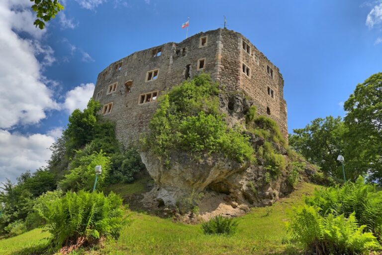
The core castle contained a densely built courtyard dominated by the surviving keep, the principal fortified tower. The keep has a square plan, with each side measuring 7.35 metres. Its lower section is made from large reddish sandstone blocks with raised, roughly finished faces and clamp holes. The original entrance was elevated on the southwest side, approximately 11 metres above ground level.
The present complex includes a 24-metre-high observation tower. A staircase installed during modern conservation work provides access within the tower and forms part of the surviving structure’s current arrangement.
Residential and Economic Areas
An approximately 11-metre-long palas, the principal residential or representative building of a medieval castle, stood against the northeast side of the keep. Together with other ancillary buildings, it formed the central residential and functional area. The complex was probably entered through a gate tower.
East of and below the keep, an artificially levelled area formed the economic quarter. The middle wall ring protected this working area, linking it to the wider defensive organization of the castle. The 1988 probing excavation examined the location and extent of the former buildings within the courtyard, while secured wall sections preserve parts of the ruin’s later appearance.
Nearby sites