Rákóczi Fortress, Ghimeș: A Frontier Customs and Defense Post
Site at a Glance
- Country
- Romania
- Primary era
- Early Modern
- Eras represented
- Early Modern, Modern
- Civilizations
- Austria-Hungary, Habsburg, Ottoman, Principality of Transylvania
- Site type
- Military
- Remains
- Fort
On this page11 sections
History
Rákóczi Fortress, Ghimeș is a frontier fortification in Ghimeș Pass, Romania, built in the 1620s on the border between Transylvania and Moldavia. Commissioned by Gabriel Bethlen, prince of Transylvania, it was intended chiefly to watch movement through the valley and collect customs duties, rather than serve as a major military stronghold.
Construction and frontier duties
In 1619, the Transylvanian Diet, the principality’s representative assembly, noted that no fortress stood in the pass. Bethlen ordered one as part of a broader effort to secure the frontier roads. Construction followed in the 1620s. The year 1626 is traditionally given for its completion, and the autobiographer György Tatrosy associated a castle he called Csikhavas with the site. Later memoirs by János Kemény, another prince of Transylvania, also place the building work in that decade.
The Székely seats, traditional administrative districts of the Hungarian-speaking Székely people, bore much of the cost of frontier fortifications. Records from 1626 and 1630 note their contribution. A document dated June 7, 1634, provides the fortress’s earliest recorded name and places Bálint Lőrincz and his company on guard there. Later tradition credits either George I or George II Rákóczi with strengthening the fort in the mid-17th century, a possible origin for its present name.
Customs and guard records show how the post operated. In 1677, two guards were listed at its customs station in peacetime; a record from 1681 gives ten for wartime. The fortress monitored passage and trade through the pass, duties that continued as political control of Transylvania changed.
Habsburg frontier and quarantine
The 1691 Diploma Leopoldinum, a charter regulating Transylvania’s constitutional status under Habsburg rule, placed the principality within the Habsburg Empire. The fortress retained its customs and border-monitoring work, while its wider defensive role grew. On February 14, 1694, Ottoman-Tatar forces entered Székely Land through the pass. Heavy snow helped conceal their approach, and the people of Csík were unprepared; the fortress had very few guards. From 1695, its walls, defenses, and earthworks were reinforced. Work continued through 1698, with further construction in 1711, helping protect the frontier from incursions and the spread of plague.
A quarantine station at the pass held people seeking entry for several weeks for health checks. In 1764, Maria Theresa appointed the Franciscan friar Reparolis Vicentius as chaplain there; he also taught local children. A public-health ordinance issued in 1770, based on the work of Transylvania’s chief physician Adam Chenot, began to standardize quarantine procedures. Repairs to the fortress and its defenses were completed by 1771. A plan from that year depicts military and quarantine facilities alongside homes that had grown up around the crossing during Maria Theresa’s reign. Habsburg emperor Joseph II visited in June 1773, while Maria Theresa’s court also sought information that year about plans for a church at the pass.
On July 12, 1788, during the Habsburg-Ottoman War, a conflict between the two empires, about 2,000 Ottoman soldiers attacked the defensive line. The defenders drove them back, preventing their advance into the country. Four additional earthworks were built that year. In 1799, Count József Teleki described a customs post, quarantine station, upper guard posts, four projecting defensive works, and a stone wall. Goods brought through the crossing from Moldavia included wool, horses, wine, and pigs. Cattle also featured in local commerce, including trade conducted by Armenians.
Local tradition tells that in 1789 the Székely hussar Lacz András rode his horse up and down the steep covered staircase to the fortress. In 1868, historian Balázs Orbán proposed that the fort had been built using the ruins of an earlier Ghimeș Castle. That same year, records of the garrison show 600 soldiers stationed at the crossing. The fortress, listed as B2, had 40; other named positions had garrisons of 40, 60, 50, and 30. The quarantine institution closed in 1873. A larger border-fortification program was under way by 1876, and the system had grown to eight units by 1878.
Railway and modern reconstruction
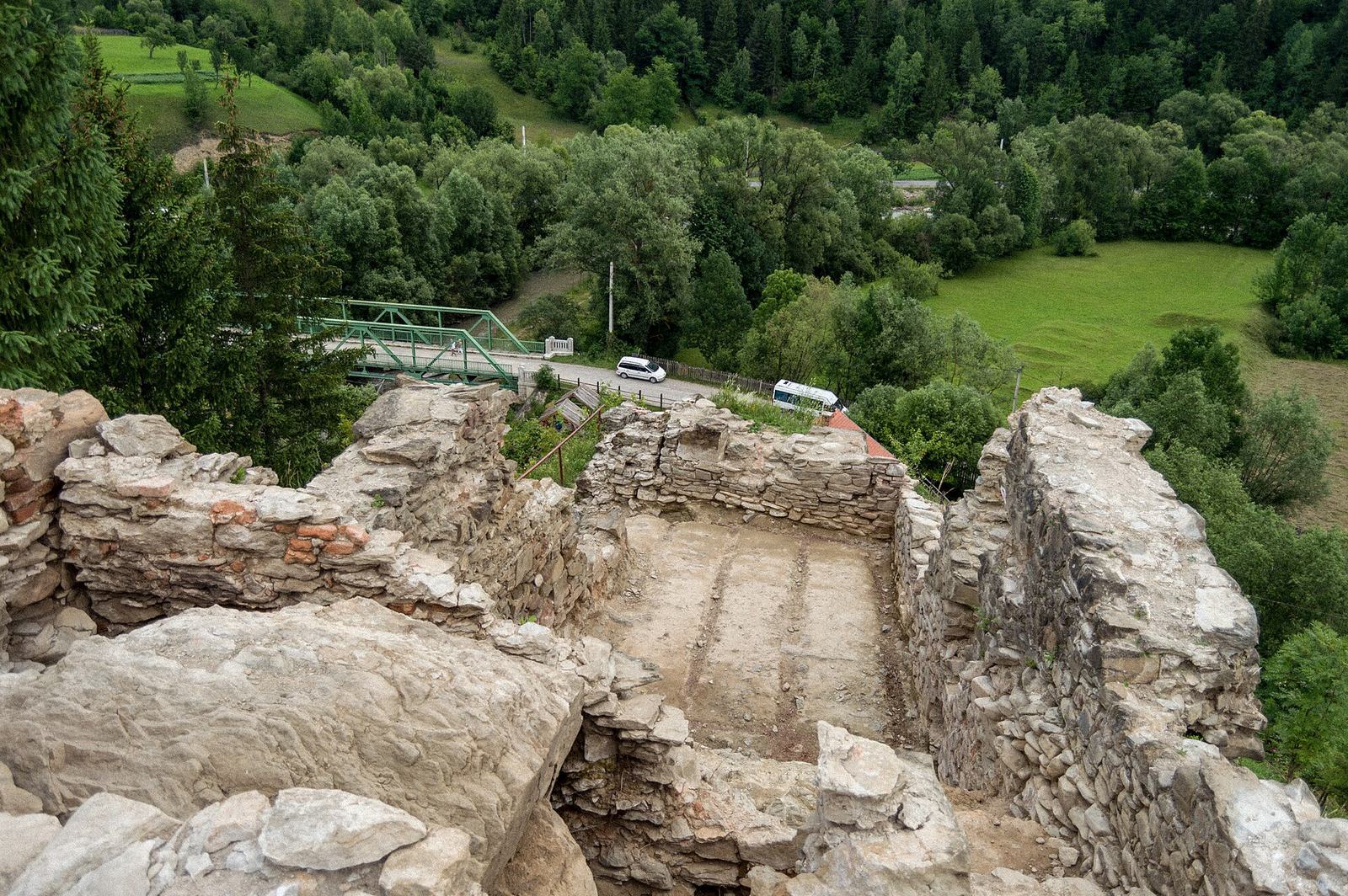
Hungary and Romania agreed in 1894 to build a railway through the valley. On the Hungarian side, railway work cut 15 metres into the hill beneath the fortress, removing the old staircase and covered passage. A steeper replacement staircase was completed by 1900. Rail traffic opened on the Hungarian side on October 18, 1897, and on the Romanian side on April 5, 1899. The fortress deteriorated during the 20th century. Deáky András began a restoration effort around 2010, and archaeological investigations followed in 2015. In 2024–25, the local government rebuilt the fortress from its ruins with the aid of original survey plans preserved in Vienna’s War Archive. A history exhibition opened at the site in 2026.
Remains
The fortress stands on a rocky outcrop above a bend in the Trotuș River, in the pass between Ghimeș and Palanca. The outcrop is known as Kő-orr; 18th-century records call the mountain Áldomás-hegy. The defensive system extended down the valley and across the river, combining the fortress with walls, wooden palisades, trenches, and outlying forts. Maps and plans show the system changing over time, while surviving remains include parts of the outlying defenses and the reconstructed fortress.
The fortress
A 1718 military map depicts the fortress as a standardized Habsburg mountain stronghold and labels it a blockhouse, a small fortified building. By 1733 it was shown as a ruined, rectangular, tower-like structure that had also served as a gunpowder store. A plan and section from 1768 depict its broadly established form: a one-storey building set into the slope, with one room on each level. The ground-floor entrance faced northeast; an entrance at the upper level’s southwest corner opened toward the ridge behind the building.
Repairs completed by 1771 included rebuilding the west wall, extending the south wall westward, and adding a small structure near the southwest corner. Drawings from 1854 show a staircase in the northwest corner connecting the floors. Each level had a larger room to the east and a smaller one beside the staircase; the upper room had a stove. A small room was added at the western end during the second half of the 19th century, adjoining the west end wall and the north wall of the ridge staircase. Photographs from 1896 show the fortress as a burned ruin, with much of its wall height still standing. A 1876 section depicts it without a roof or the floor between its two levels.
Outlying defenses
Walls and valley barrier
A 1733 map shows a ruined defensive wall descending from the fortress toward Fort B. Firing openings pierced the wall, and a firing trench surrounded it. A wooden defensive fence continued from Fort B to the Trotuș and crossed the river to Fort A, forming a barrier to uncontrolled movement through the valley. A drawing from 1735 shows the crossing and its buildings in much the same arrangement, with the fortress and both outlying forts in ruins.
Forts and earthworks
On the 1733 map, Fort A is square and Fort B pentagonal; both lie east of the fortress, on opposite sides of the river. Plans from 1780–81 show new trenches and palisades, a closed defensive passage descending from the fortress’s northeast corner along the valley wall, and a palisade linking the three forts. A detailed plan from 1791 includes the four earthworks built in 1788 and another fortification at the western end of Áldomás-hegy, reached by an artillery road along the ridge. A blockhouse had occupied that position before 1733, when it was already described as destroyed.
Drawings from 1854 depict five forts in the crossing’s defensive system, including two timber-built structures on its eastern side. The border gate had two cannons. By 1878, two more forts had been built northeast of the crossing, and the fortification at the western end of Áldomás-hegy had been rebuilt. Ruins of Fort A remain near the meeting of the Trotuș River and Sânc Stream. Earthworks, palisade traces, and remains of northeastern defensive elements can still be seen in the valley.
Quarantine Chapel
The Quarantine Chapel stands among the former quarantine buildings. During renovation in 2008, workers uncovered an Armenian inscription dated 1712 beneath plaster on its north wall, indicating that a quarantine building already existed by that year. The chapel may have been created later by enlarging one of the early buildings used for quarantine.
Railway features
Photographs from 1896 show a covered passage along the valley-blocking wall, containing a 134-step staircase to the fortress. Railway construction removed both passage and staircase; a replacement staircase with 96 steps was in place by 1900. The former Hungarian State Railways guardhouse no. 30, built in 1896–97 a few metres from the border, was the railway’s easternmost guardhouse.