Prehistoric Village of Cambous: A Final Neolithic Settlement in France
Site at a Glance
- Popularity
- Medium
- Country
- France
- Primary era
- Stone Age
- Eras represented
- Stone Age, Modern
- Civilizations
- Unclassified
- Site type
- Settlement
- Remains
- Village
On this page16 sections
History
The Prehistoric village of Cambous is a settlement in France associated with the Fontbouisse culture of prehistoric Languedoc. It belongs to the Final Neolithic, also called the Copper Age in this region, when people used copper alongside stone tools. The latest huts at Cambous date to 1800 BC.
Life in the Fontbouisse settlement
The clustered village existed alongside isolated huts in the surrounding area. Its spread-out layout, level setting, and lack of defensive works have been interpreted as signs of a relatively secure period. Individual huts could house 5 to 20 people. If all were occupied at once, the settlement may have supported 200 to 300 people.
Agriculture and the keeping of domestic animals formed part of life at Cambous. People ate wheat and barley, ground or roasted, and hunting provided about a fifth of the meat they consumed. Animal remains are mostly from cattle, sheep, pigs, goats, and dogs, with sheep and goats especially common.
After the village
Occupation continued sporadically after the Fontbouisse population left. By the beginning of the Bronze Age, the village was probably already in ruins.
Discovery and management
Henri Canet, a member of the Brothers of the Christian Schools, found the site during a surface survey in 1967. A proposed road for a planned housing development threatened the location. The development did not proceed after France’s Ministry of Defense acquired the Cambous plateau for a military training ground.
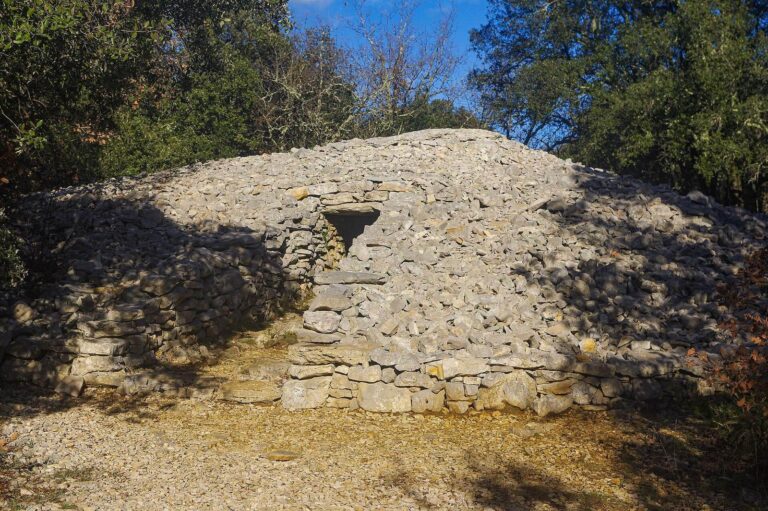
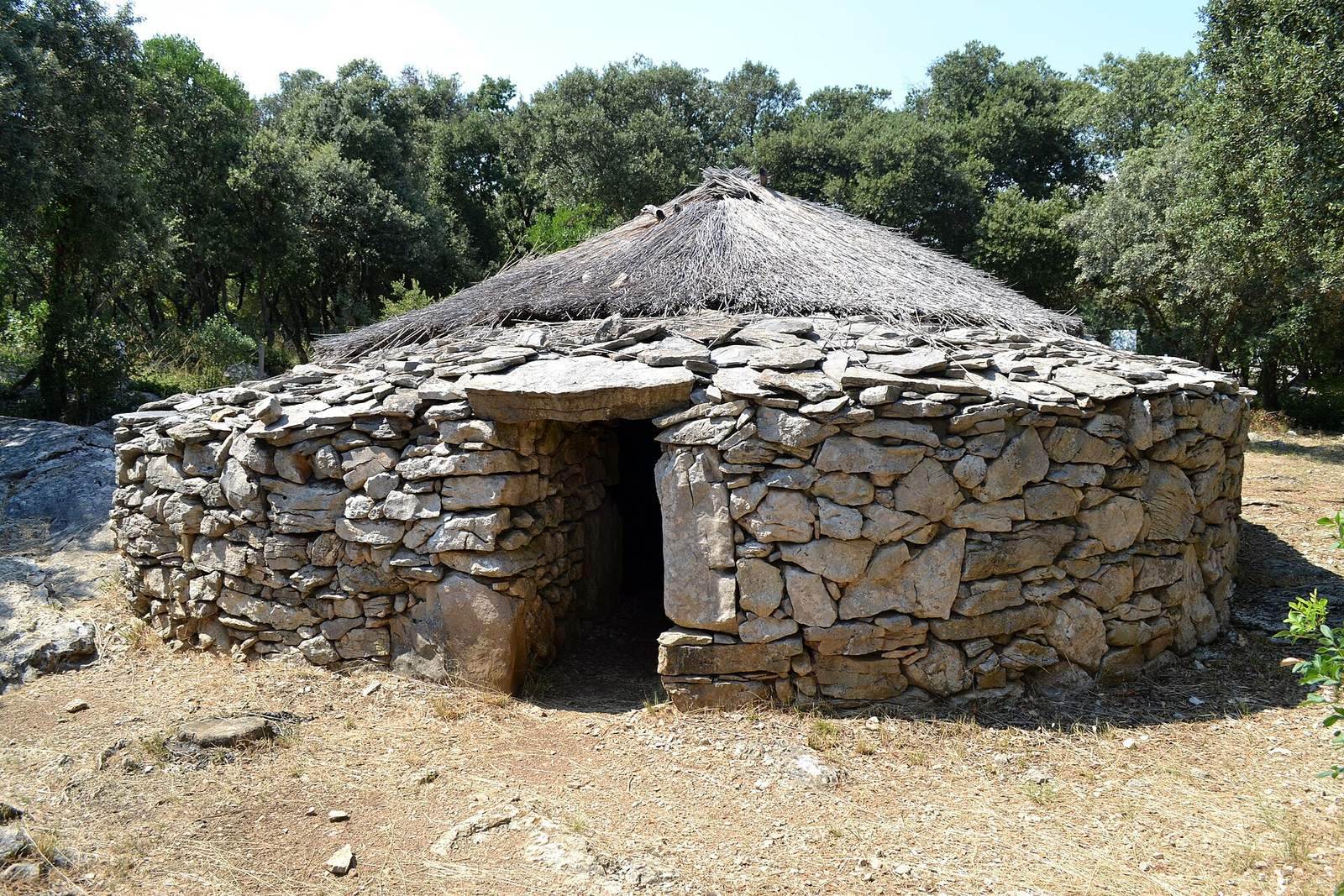
The regional prehistoric research society Société languedocienne de préhistoire has managed the site since 1976, with research and archaeological outreach among its aims. A hut reconstruction for educational use was built in 1983 and renovated in 2008.
Remains
Cambous covers about one hectare and forms part of a wider prehistoric landscape extending roughly 5 km east to west between Viols-le-Fort and Cazevieille, and 2 km north to south. This landscape contains 15 Copper Age sites, 14 dolmens, and about 30 isolated huts.
Settlement layout and huts
Four hut clusters
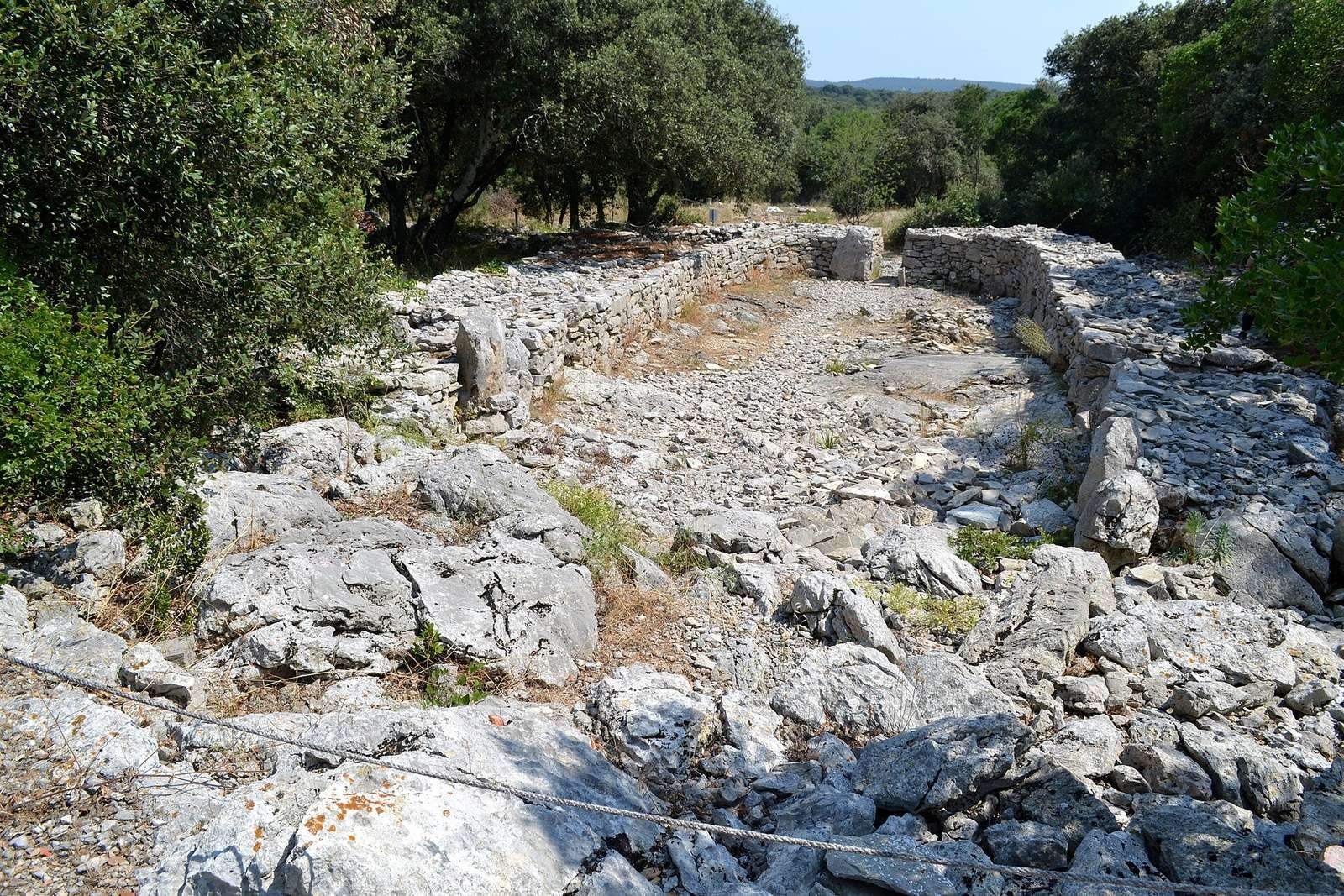
The village was arranged in four distinct groups, each about 50 to 100 m from the next. Each group contained roughly 8 to 10 adjoining huts, making 35 to 40 in all. Some huts connected directly through passages in their walls. Groups A and B are the best preserved; stone from the other two groups was quarried for nearby lime kilns. In Groups A and B, walls fell inward from their outer faces, leaving low mounds that shielded the archaeological layer from erosion. Group A is especially well preserved, with ten structures fully exposed.
Hut form and construction
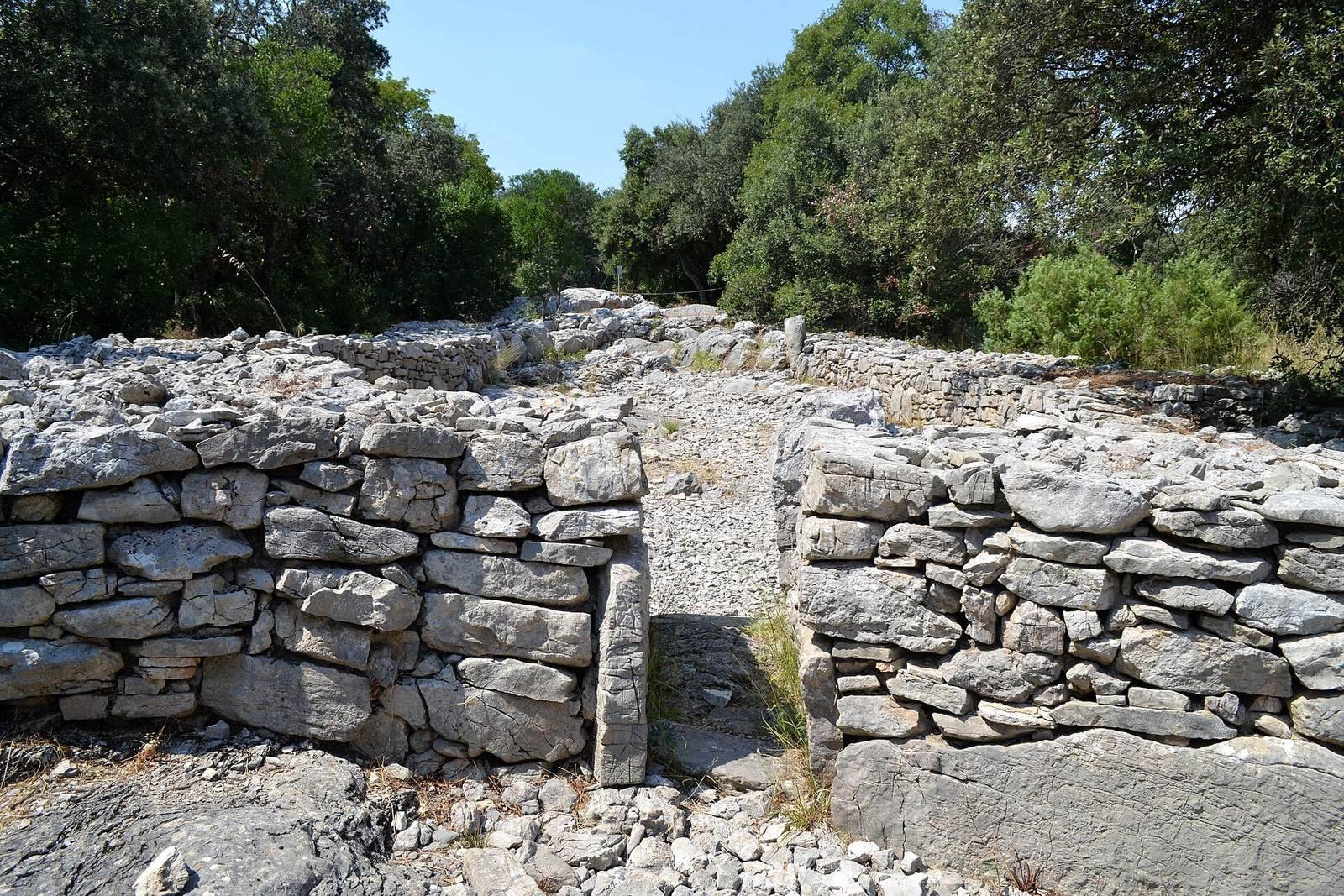
Huts were elongated rectangles or ovals, with rounded end sections called apses. Their interior lengths ranged from 8 to 24 m. Hut 11, the most closely studied example, measures an average of 20.50 m long and 5.30 m wide inside. Walls, 1 to 2.50 m thick and 1 to 2.50 m high, were laid directly on clay or underlying rock. Two stone faces enclosed a loosely arranged fill of blocks; the inner face was more carefully built, with flat slabs set upright in a regular pattern.
The unusually thick walls may reflect the deliberate removal of stones from the occupied ground before building, possibly to make the area easier to use for grazing later. Hut layouts also changed over time. Hut 3, for example, began at 18 m long and was later extended by 6 m without becoming wider.
Entrances and roofs
Doorways were about 0.50 m wide, often with small upright stones marking their corners. An entrance generally opened on the north or south side along a hut’s length, where it was sheltered from prevailing winds. Some huts also had a side doorway leading outdoors or into a neighboring hut. Connecting passages were usually paved. Paving also survives in a few square metres of Hut 11 in Group B and outside the entrance to Hut 2 in Group A. The relatively dry, permeable ground may explain why more floor paving was unnecessary.
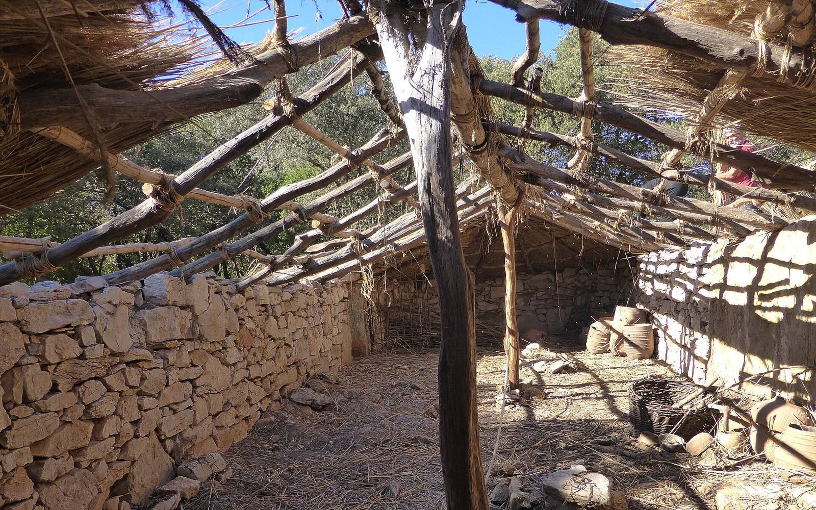
Roofs combined plant materials with thin slabs of soft limestone brought from a deposit farther north in the Saint-Martin-de-Londres basin. The slabs were more common on smaller Huts 4 and 5; bundles of local grasses or reeds gathered near watercourses may also have been used. Postholes with packing stones show that simple roof frames rested on posts set about 4 m apart along the huts’ long axes.
Interior spaces and activities
Huts 1 and 2 each had two main interior areas, with a hearth between them. Their northern areas contained more pottery, flint implements such as arrowheads, scrapers, and knives, bone tools including awls and polishers, and ornaments made of stone, bone, and shell. These spaces probably held food stores. Southern areas near the exits had fewer finds and probably served as sleeping places.
In Hut 3, a rocky bench served as a seat for a flint worker. Hammerstones, cores, blocks, and flakes found there point to stone-tool making. Hearth remains, cooking equipment, and tools also came from areas outside and near the huts. Animal bones bear clear marks of cooking and butchery.
Ground features and finds
Limestone ground and well
The village lies on exposed limestone, marked by small natural shafts and sinkholes. Some had low stone walls around them. They may first have been used for storage and later as refuse pits, and they yielded abundant archaeological material. An oval well north of Hut 11 measures 2 by 1 m and is 4 m deep; it contained fragments from 18 vessels.
Pottery and stone tools
Pottery is the principal find, though it is highly fragmentary. More than 400 kg came from Hut 11. The vessels belong to the Fontbouisse culture and were made from local clay mixed with carefully ground local limestone or calcite. Small pots were sometimes polished with a hard tool, while larger ones were smoothed less precisely by hand. Their forms are simple, with rounded bases and plain handles shaped like short rolls or small knobs.
Stone finds include rough tools made from river pebbles, such as hammerstones, as well as finished flint implements, including leaf-shaped arrowheads and thick scrapers. Two complete axes and fragments of three others were found in cracks in the walls of Hut 2. Granite grinding stones may have been used to make flour from grain or to grind calcite for mixing into pottery clay.
Copper objects
Copper finds are uncommon. They include a dagger from Hut 12, a wedge from Hut 11, needles, a chisel, and necklace beads from Huts 3 and 11. Analysis of the 17 copper objects found at Cambous indicates that three were made from ore from the Cévennes and seven from ore from the Cabrières–Péret area of the Montagne Noire. The others were made using a mixture of ores from those regions or by remelting older objects.
Burial and nearby monuments
A newborn was buried in a vessel near Hut 11. Nearby prehistoric burial monuments include Cambous Dolmen and Draille Dolmen, both dolmens, or tombs built from large stones, as well as the oval tombs at Cazarils.
Educational reconstruction
The reconstructed hut provides an educational version of a Cambous dwelling. Built in 1983 and renovated in 2008, it reflects the site’s use for archaeological outreach.