Olynthus: A Greek City and Center of the Chalcidian League
Site at a Glance
- Popularity
- High
- Country
- Greece
- Primary era
- Classical
- Eras represented
- Stone Age, Iron Age, Classical
- Civilizations
- Ancient Greek
- Site type
- City
On this page24 sections
History
Olynthus was an ancient Greek city in Chalcidice, Greece, whose historical beginnings are generally placed in the seventh century BCE. The area had been settled much earlier: a Neolithic community, from a prehistoric period when farming and stone tools became increasingly important, occupied the South Hill during the fourth millennium BCE and flourished around 3000–2900 BCE before its settlement ended.
Early settlement and Persian capture
The city’s beginnings are associated with Bottiaeans, an ancient people displaced from Macedon. A separate foundation tradition connects Olynthus’s name to a figure from Greek myth, described as a son of Heracles or of Strymon. In that story, his brother Brangas established the city in his honor.
Olynthus submitted to Xerxes I, the Achaemenid Persian king, in 480 BCE. After the city revolted, the Persian commander Artabazus captured it in 479 BCE and killed many Bottiaean inhabitants. He placed control in the hands of Critobulus of Torone, and a Greek Chalcidian population later settled there. A destruction layer from the fifth century BCE is associated with the Persian capture.
League membership and expansion
Olynthus belonged to the Delian League, an alliance of Greek city-states led by Athens. It appears in the league’s tribute records from 454/453 to 433/432 BCE, with its contribution listed at about two talents in 438 BCE.
In 432 BCE, during the conflict between Athens and the Peloponnesian alliance led by Sparta, Macedonian king Perdiccas II encouraged several coastal Chalcidian communities, including Mecyberna, Singus, and Gale, to move their populations to Olynthus. Its inland position was easier to defend. This consolidation greatly enlarged the city and accompanied the formation of the Chalcidian League, a confederation of cities on the Chalcidice peninsula, with Olynthus as its leading member.
Olynthus later fought Athens alongside Sparta’s alliance. After the Peace of Nicias in 421 BCE, it continued to contest the future of the Chalcidian League. The league’s growing power brought it into conflict with Sparta. During the First Olynthian War, fought from 382 to 379 BCE, Sparta intervened with Macedonian support. Olynthus surrendered in 379 BCE and formally agreed to dissolve the league.
The league later recovered under Olynthian leadership and grew to include more than 30 cities. It regained importance after Sparta’s defeat at Leuctra in 371 BCE.
Conflict with Philip II and abandonment
Olynthus initially allied with Philip II of Macedon, who granted the city Anthemus and Potidaea after his conquests. As concern over his expansion grew, Olynthus sought to restore relations with Athens, reaching a peace agreement in 352 BCE. It requested Athenian assistance in 350–349 BCE and, in 349 BCE, sheltered Philip’s half-brothers Arrhidaeus and Menelaus as they fled him. The Athenian statesman and orator Demosthenes urged Athens to help, but assistance arrived too late.
Philip captured and destroyed Olynthus in 348 BCE after its leaders Euthycrates and Lasthenes, the commander of its cavalry, betrayed the city. The inhabitants, including an Athenian garrison, were enslaved. A smaller settlement continued on the North Hill until at least 316 BCE. Its residents probably later moved to Cassandreia, founded by Cassander on the site of Potidaea, after which Olynthus seems to have been permanently abandoned.
Rediscovery and excavation
The ancient site was once mistakenly placed at Agios Mamas. Alan Wace and other scholars argued for a location near Myriophyton, and Wace surveyed the area in 1915. David Moore Robinson is also credited with identifying the site in 1902. He led major excavations beginning in 1928 in collaboration with the American School of Classical Studies at Athens; further seasons took place in 1931, 1934, and 1938. The work exposed more than five hectares of Olynthus and part of its harbor, Mecyberna.
The rapid excavation left the South Hill’s archaeological evidence difficult to interpret. Later work by Nicholas Cahill reconstructed much of the North Hill’s sequence of deposits. Some of Robinson’s published work was subsequently found to have copied research by fellow excavator Mary Ross Ellingson.
Remains
Olynthus occupied two hills east of the Vatunia River, known in antiquity as the Sardanos, on a fertile plain near the head of the Gulf of Torone. The site lay about 2.5 kilometres from the sea. The hills ran roughly 1,200 metres from south to north and rose about 30–40 metres above the plain; the South Hill reached about 59 metres above sea level and the North Hill about 65 metres. The older settlement occupied the South Hill, while the classical city’s orderly grid spread across the North Hill and the Villa Section to its east.
Early settlement and the South Hill
Neolithic occupation
At the edge of the South Hill, excavators identified five houses belonging to three Neolithic settlement phases. Only their foundations, built from mud and river stones, survived. The pottery was mainly monochrome, with additional incised and painted examples. The settlement also yielded the oldest potter’s kiln yet discovered in Greece.
Older city
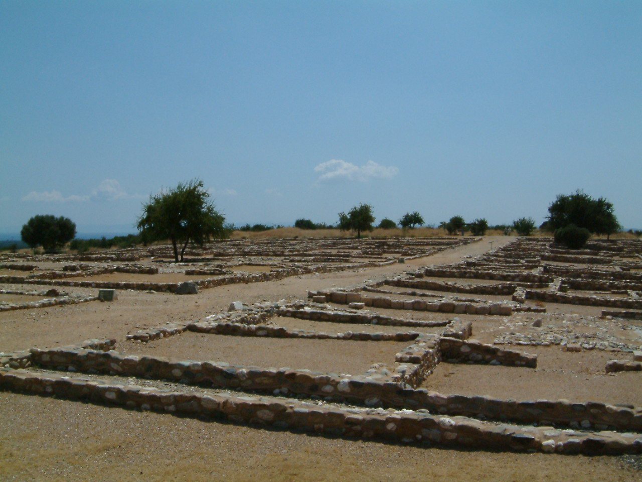
The older city covered about six to seven hectares and had a dense, irregular plan. Two main streets followed the eastern and western edges of the hilltop, with cross streets linking them. Houses and rooms were relatively small, while public and administrative buildings gathered near the hill’s northern end. A public building there measured about 32 by 16 metres; another large structure, probably also public, stood to the south of the older city.
Classical districts and street plan
North Hill
The North Hill covered about 17 hectares. Excavations uncovered 108 buildings there, and the city may have contained around 360 houses with a population of 2,000–3,000. Blocks were generally about 88.5 by 35.4 metres, with as many as ten plots arranged in two rows of five and usually separated by a narrow alley. Individual plots measured approximately 58 by 57.5 feet. North–south streets were about 5.8–9.2 metres wide, while east–west streets were generally around five metres; the principal north–south road was wider than the others.
Villa Section
The eastern Villa Section covered about 16 hectares and followed a slightly different street orientation, with a less regular layout than the North Hill. It had at least two north–south roads, about 6.3 metres wide, and 16 east–west roads, generally around five metres wide. Some plots may have served as gardens. Houses varied more in form and were often larger than those on the North Hill.
Defences and public buildings
City wall
A wall protected the expanded classical city by 381 BCE. On the North Hill, surviving foundations support a reconstruction of a mud-brick wall about 3.25 metres thick, with defensive towers at intervals of roughly 42 metres. Foundations remain in the north and other parts of the site, and one stretch of the wall also formed the western sides of houses in a row. A gated section separated the North Hill from much of the Villa Section.
Public area on the North Hill
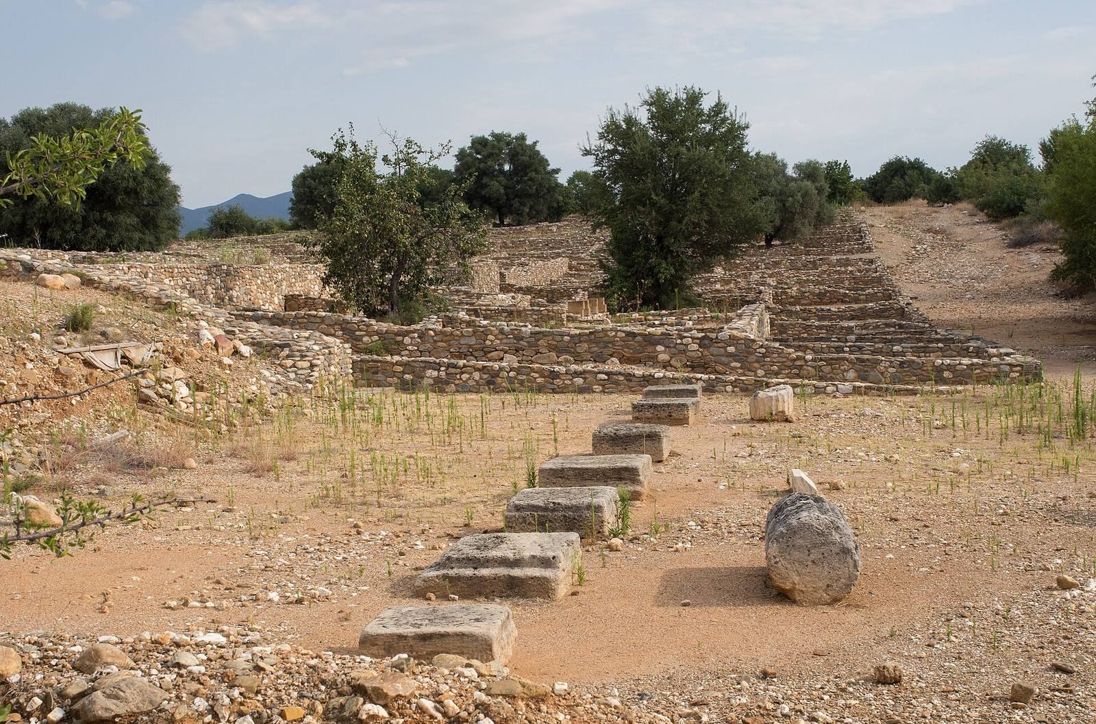
An open area on the southern part of the North Hill measured roughly 130–135 by 85 metres. It is usually interpreted as the agora, or central public square, though it has also been proposed as a sacred precinct. A roofed colonnade, or stoa, stood along its northern side. To the east was a building about 19 by 9.5 metres, probably used as a meeting or council hall. Its roof rested on seven columns in the Doric style, one of classical Greece’s principal column designs. A fountain house bounded the area to the northeast, and a well received water through a pipe.
Possible performance space
A recess on the southeast slope of the South Hill may have provided space for spectators and performances. Its possible use offers a clue to how the hillside could have accommodated public gatherings.
Houses and water systems
North Hill houses
Many North Hill homes followed a pastas-house plan. A typical house, about 17 by 17 metres, had a courtyard toward the south and a two-storey residential range to the north. A pastas, a shaded gallery or porch, opened onto the courtyard. House walls were made of mud brick on stone foundations, and entrances varied with each home’s position in its block. Some houses also had street-front shops or workshops.
Rooms commonly included an andron, a space for men’s dining and drinking gatherings, often about 4.8 by 4.8 metres and usually furnished with seven couches. Kitchens had a hearth and an outlet for smoke, and wooden stairs resting on stone bases led to upper-storey rooms, including bedrooms. Bathrooms occurred in about a third of the houses. Some contained terracotta tubs suited to seated washing with hot water. Three houses had fixed clay latrines, and clay drains carried wastewater, and in one case latrine waste, toward channels between house rows.
Villa Section houses
Homes in the Villa Section had more varied plans than those on the North Hill. Many used a peristyle, a courtyard surrounded by columns, rather than the North Hill’s more modest porch arrangement. Two connected eastern rooms in one house had mortar floors with inscriptions praising Tyche, the personification of fortune, and Aphrodite, associated with love and desire. Their walls bore painted designs imitating blocks of several colours.
Water supply
Residents drew water from the perennial Sardanos, occasional household cisterns, and a public network of terracotta pipes. The network carried water from a spring in the hills near Polygyros, about eight kilometres north of the city, and parts of it worked under pressure. Some pipes may date as early as the seventh century BCE. Two wells have been identified in the city, alongside a poorly preserved public fountain on the North Hill. Rainwater cisterns occurred in relatively few houses.
Mosaics, burials, and finds
Mosaics and decoration
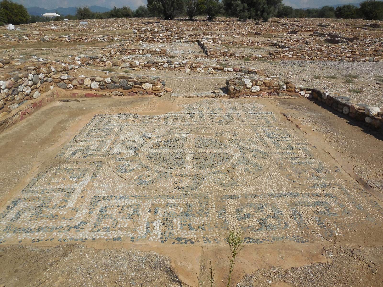
The same Villa Section house with the inscribed rooms had pebble mosaics in its andron and anteroom. One depicts the presentation of Achilles’ arms; the other shows Dionysus, associated with wine and festivity, celebrating in a chariot. Olynthus’s pebble mosaics are among the earliest known from classical Greece. One notable example portrays Bellerophon, wearing a broad-brimmed hat called a petasos and riding the winged horse Pegasus, as he spears the Chimera. The monster has a lion’s body and head, a serpent’s tail, and a goat’s head on its back.
Cemeteries and tomb
Three cemeteries are known around the city. The largest, beside the Sardanos to the west, contained 560 investigated graves. Another cemetery north of the city had about 30 graves, and a third lay east of the South Hill. A chamber tomb, a burial space with an enclosed room, was also found west of Olynthus; it followed a Macedonian type.
Household and economic finds
Excavations recovered 793 clay loom weights, as well as spindles, spindle whorls, and bobbins. Other finds included pottery, figurines, household objects, and coins issued by Chalcidian cities. Inscriptions on houses recorded sale or rental prices ranging from 230 to 5,300 drachmas. Grain mills used a hopper to feed grain between millstones and a long lever for turning them; olive mills for pressing olives were also found. Most of the finds are held in the Archaeological Museums of Polygyros and Thessaloniki, while the coins are in the Numismatic Museum of Athens.