Naxos: An Early Greek Colony in Sicily
Site at a Glance
- Popularity
- High
- Country
- Italy
- Primary era
- Classical
- Eras represented
- Bronze Age, Iron Age, Classical
- Civilizations
- Ancient Greek, Roman
- Site type
- City
On this page24 sections
History
Before the Greek settlement
The peninsula was inhabited almost continuously from the Neolithic period until Greek settlers arrived. Middle Bronze Age huts are associated with the Thapsos culture, an archaeological label for prehistoric Sicilian material, and with the Sicani, an ancient people of Sicily. Iron Age remains belong to the Cassibile phase, a label for early Iron Age material, and are associated with the Siculi, another ancient people of the island. At the time of the Greek arrival, Siculi occupied the surrounding heights.
Founding and early expansion
Naxos was an ancient Greek colony on Cape Schisò in present-day Giardini-Naxos, Italy. Settlers from Chalcis in Euboea and the Cycladic island of Naxos founded it in 734/735 BC. It was regarded as Sicily’s earliest Greek colony and was established a year before Syracuse. Thucydides identifies the settlers as Chalcidians, while Ephorus includes other groups, among them Ionians. Ephorus also describes Theocles as Athenian by birth and as the settlers’ leader and the city’s founder.
The settlers established an altar to Apollo Archegetes, meaning Apollo in his role as leader or founder. Naxos became a religious reference point for later Greek settlements in Sicily. Sacred envoys travelling to Greece or returning to Sicily traditionally sacrificed at the altar, a custom that continued after the city was destroyed.
Naxos sent settlers to found Leontini around 730 BC and Catana soon afterward. Theocles is associated with the foundation of Leontini, and Euarchus with that of Catana. Naxian involvement in the settlement of Zancle, later Messina, is possible but unconfirmed. Callipolis may also have been a Naxian colony, although its location remains uncertain.
Conquest and rebuilding in the fifth century BC
Hippocrates, ruler of Gela, besieged and captured Naxos around 492–491 BC. The city then came under the authority of Gelon of Syracuse and later Hieron I. In 476 BC, Hieron removed the inhabitants of Naxos and Catana to Leontini and settled new populations in their cities. Naxos was rebuilt around 470 BC, probably under Hieron’s direction.
After the ruling Deinomenid family of Syracuse fell in the mid-fifth century BC, exiled Chalcidians returned. Naxos was back under their control by about 461 BC. It joined Catana and Leontini in an alliance against Syracuse and other Dorian cities in Sicily.
Conflict and destruction
During the fighting around Leontini in 427 BC, Naxos supported its Chalcidian allies. It also joined an Athenian expedition to Sicily led by the generals Laches and Charoeades. In 425 BC, Messenians attacked the city by land and sea, but the Naxians drove them back and inflicted heavy losses. Naxos later supported Athens’ larger expedition of 415–413 BC, supplying the Athenian forces and receiving them into the city. After crossing the Strait of Messina, the Athenian fleet made its first stop at Naxos.
Following the failure of the Athenian expedition, conflict between the Chalcidian cities and Syracuse was suspended in 409 BC as the threat from Carthage increased. Naxos therefore escaped the fate of Agrigentum, Gela and Camarina for a time. In 403 BC, Dionysius I of Syracuse, a sole ruler outside ordinary civic institutions, conquered Naxos after its commander Procles betrayed the city. Dionysius sold its inhabitants into slavery, destroyed its walls and buildings, and transferred its territory to the Siculi. Naxos ceased to be a city-state.
Exiles and the Roman period
Some survivors appear to have returned, rebuilt buildings and issued coins under the name Neapolis, but the settlement did not regain its former urban importance. Around 396 BC, the Siculi established a settlement on nearby Mount Taurus that developed into Tauromenium. Naxian and Catanian exiles formed a community, but an attempt by Rhegium, a Greek city on the Italian side of the Strait of Messina, to settle them at Mylae, modern Milazzo, failed when the Messenians expelled them in 394 BC. In 358 BC, Andromachus gathered Naxian exiles from across Sicily and settled them at Tauromenium, which became Naxos’s successor.
The former city no longer functioned as an urban centre, but the sanctuary of Apollo Archegetes remained in use and continued to mark the site. The sanctuary is mentioned in connection with the conflict in the surrounding waters between Octavian, later Augustus, and Sextus Pompey, son of Pompey the Great, in 36 BC. A Roman stopping place on an official route was also associated with the area.
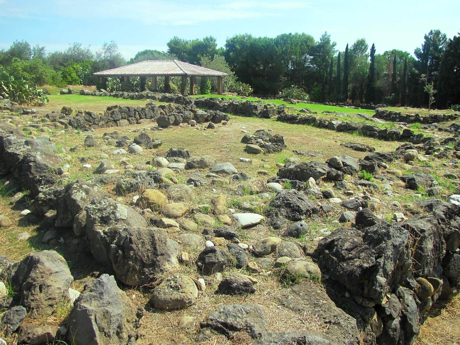
Archaeological excavations have exposed parts of the settlement and clarified its successive urban plans. The remains now form part of an archaeological park with a museum.
Remains
Naxos occupies the low, rocky lava headland of Cape Schisò, immediately north of the Alcantara River, called the Acesines or Assinos in antiquity. The Bay of Naxos, between Cape Taormina and Cape Schisò, provided a natural harbour sheltered for small ancient vessels. The Santa Venera stream meets the coast near the city walls, while the Alcantara lies farther west. The archaeological area covers about 37 hectares; the ancient urban area is estimated at roughly 40 hectares, about 700 by 550 metres.
Settlement and street plans
Prehistoric and early Greek settlement
Archaeological remains include Middle Bronze Age huts and material from the Iron Age Cassibile phase. At the centre of the peninsula, excavators identified a square house measuring about 4 by 4 metres, beneath the fifth-century BC main street known as Plateia A. A built-in ledge along the rear wall provided room for household equipment.
Archaic town
The archaic settlement first extended along the coast over about 12–13 hectares and later spread inland. Its principal streets ran north–south, supporting movement between the harbour and the inland area. Excavated remains include traces of streets, houses built with fitted polygonal stonework, and sanctuaries within and beyond the settlement.
Fifth-century city plan
After the earlier town was levelled, the rebuilt city followed a regular grid set on a different alignment. Three broad main streets crossed the plan, with central Plateia A measuring 9.5 metres across. Most cross streets were 5 metres wide; the sixth west of the main axis measured 6.5 metres. Blocks generally ran northeast–southwest and measured about 175 by 39 metres, although terrain and the older sacred precinct interrupted the pattern.
Each block was divided lengthwise into four strips, each containing twelve plots of about 9 by 12 metres. Houses were generally smaller than those in other Greek cities of Sicily. Excavated homes commonly had a small entrance courtyard with compact rooms around it. The earlier street plan survives beneath the later one. The sacred precinct, some temples and the shipyard retained their original alignments during rebuilding. Square bases, consistently positioned on the eastern side of street intersections, measured about 1.5 by 1.25 metres and once carried slabs about 0.8 metres across. Their purpose is uncertain: they may have marked plot boundaries or supported altars or other ritual installations.
Defences and sacred areas
City walls
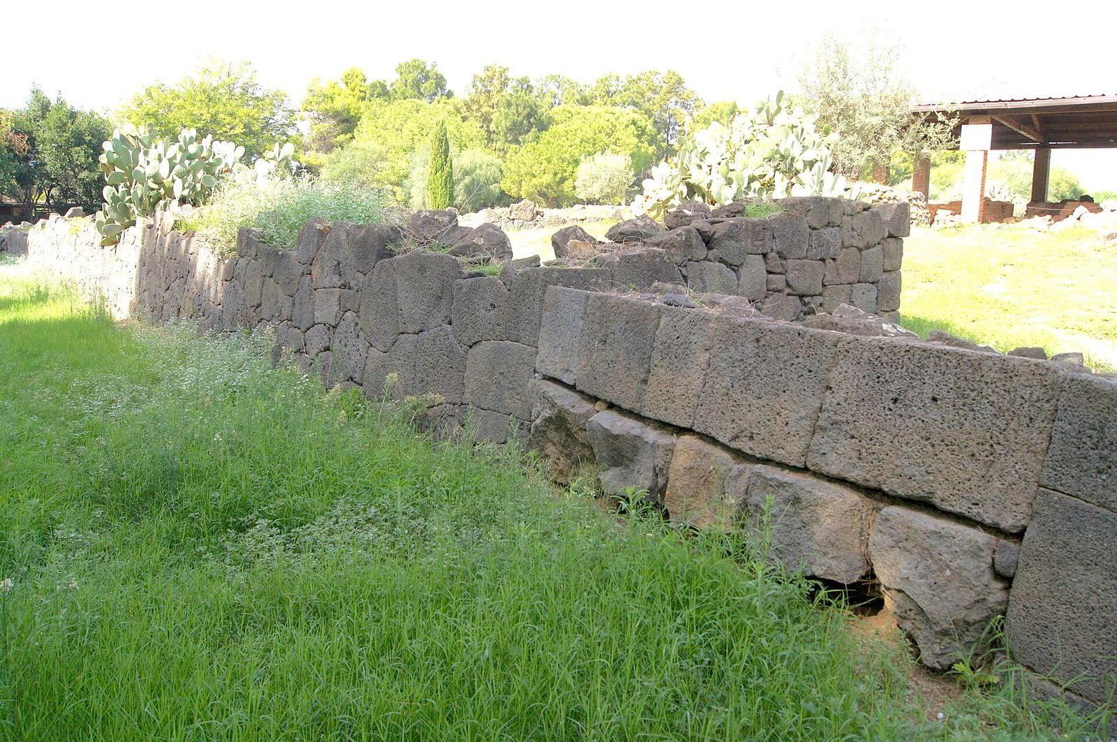
Built in the sixth century BC, the defensive circuit followed the Santa Venera stream to the west and the coastline to the south, east and northeast. Its rough lava blocks were laid in polygonal courses, with some sections made of exceptionally large stones. The walls were about 5 metres thick at their base and rose as high as 8 metres. Stone formed the lower 2 metres, with mud brick above. Six gateways have been identified: three to the west, two to the south and one to the northeast. A tower stood beside a western gate.
A surviving stretch beside the sacred precinct has two faces of roughly dressed blocks around a dry-stone rubble core. It is about 4.6 metres thick, with each face averaging 1.8 metres. The nearby western gate is more than 2.5 metres wide. The tower beside it, the only one identified on the circuit, survives in poor condition.
Southwestern sacred precinct
A large sacred precinct occupied the southwest of the city and enclosed an older sacred area. Its polygonal boundary wall includes very large blocks and two principal entrances, which incorporated architectural terracottas and roof tiles. The smaller northern entrance had both an outer and inner doorway. It became a monumental approach into the city, while the southern entrance developed into a city gate. Incorporated into the defensive circuit, the precinct functioned like an acropolis.
Temples within the precinct
The principal temple stood at the precinct’s northeastern end and may be the Aphrosidium, a sanctuary associated with Aphrodite and mentioned by Appian. Its early phase dates to the seventh century BC and is only partly understood. In the early fifth century BC it was rebuilt as a temple building measuring about 38 by 16 metres, on an alignment different from its predecessor. A high archaic shrine occupied the opposite end of the precinct. Roof ornaments bearing Silenus heads suggest that other, smaller buildings, perhaps temples or treasuries, also stood there. Architectural terracottas have helped reconstruct temple decoration, including an unusual floral ornament of palmettes and lotus flowers on the principal temple.
Altars and precinct activities
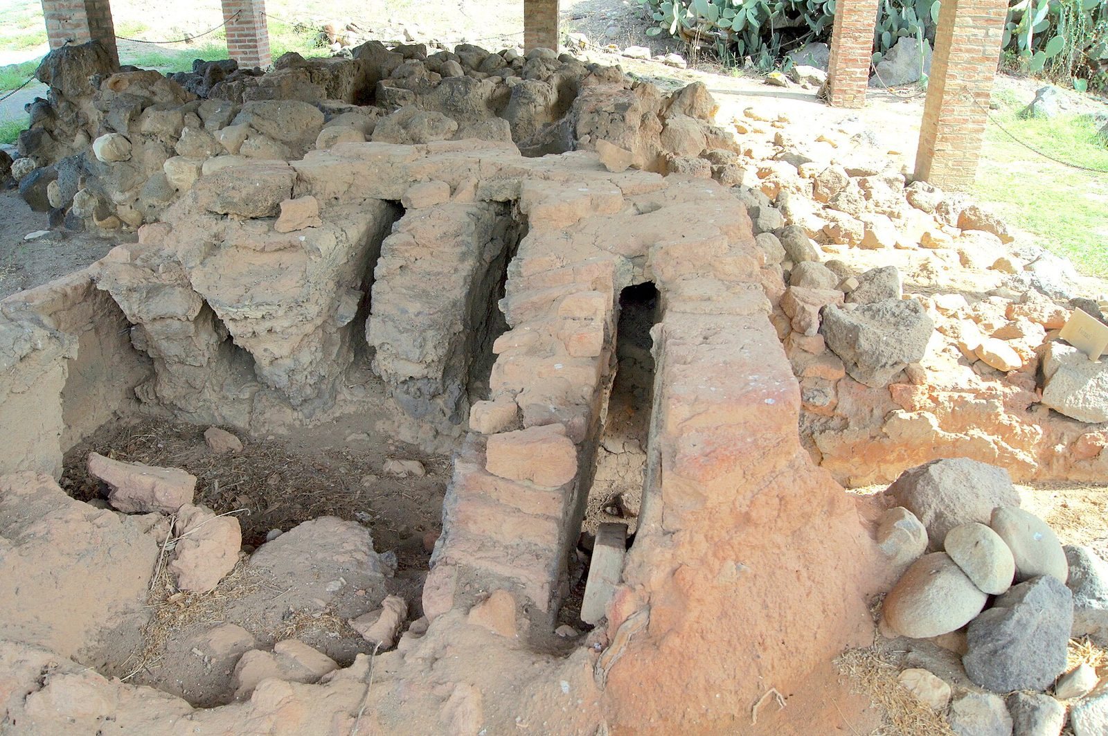
Southwest of the principal temple stood a quadrangular altar built of polygonal masonry, with three steps on its western side. Stelae and small altars bearing traces of sacrifice were also found in the precinct. Votive objects included terracotta figures, statuettes, local pottery and weapons. Two kilns served the precinct’s needs: a circular kiln for pottery and a rectangular one for roof tiles.
Other temples and sanctuaries
Temple C, a modern archaeological name for a building whose ancient name is unknown, stood near the centre of the peninsula. It was a small temple building about 2.2 by 6.9 metres, with projecting wall ends at its entrance. Its lowest course of stone blocks survives; the upper walls were probably made of mud brick. Naxos also had a fifth-century BC temple associated with Aphrodite.
A separate sanctuary on the right bank of the Santa Venera, probably the sanctuary of Apollo Archegetes, yielded abundant architectural terracottas, including part of a colossal archaic Gorgon image from a temple pediment. A marble sacred stone dedicated to Enyo, a Greek goddess associated with war, was found in 1977 in a large sanctuary west of the stream. Its inscription uses the distinctive seventh-century BC script of Greek Naxos.
Craft production, harbour and burials
Workshops
Pottery and terracotta-figure workshops operated both inside and outside the city, including two within the southwestern sacred precinct. Many lay beyond the built-up area, especially southwest between the Santa Venera and Alcantara rivers and northeast beneath the present-day Giardini-Naxos highway interchange. The northeastern workshop area included three kilns, basins for settling clay and connecting lanes.
Shipyard
The shipyard complex retained a different alignment from the rebuilt city. Its seafront façade indicates that in the fifth century BC the shoreline lay about 180–190 metres beyond today’s sandy beach, and that sea level was about 2 metres higher than it is now.
Necropolises
The archaic cemetery northeast of the city is represented by two tile-covered tombs dating to the late sixth century BC. The classical cemetery lay between the Santa Venera and Alcantara rivers and included simple tile-covered burials with modest grave goods. Later burials have been identified near the right bank of the Santa Venera and at the site of the modern cemetery of Giardini-Naxos.
Roman-period remains and coinage
Roman stopping place
Late Roman remains include a stopping place on an official route and streets cut into bedrock that follow the general line of an ancient narrow cross street. Large deposits of late-imperial amphorae also point to activity connected with the stopping place.
Silver coins
Naxos began minting silver coins by the end of the sixth century BC. Most of the surviving issues described date to the fifth century, especially around 460–403 BC. The coins use Attic or Aeginetan weight standards, two different Greek systems for weighing coinage. A sixth- to fifth-century BC Aeginetan-standard drachm, a Greek silver coin, measures 22 millimetres and weighs 5.70 grams. It shows an ivy-crowned Dionysus, the god of wine and festivity, in profile. On the reverse, the city’s name appears beneath grapes and two vine leaves.
A fifth-century Attic tetradrachm, a coin worth four drachms, measures 28 millimetres and weighs 16.85 grams. It shows Dionysus on one side and, on the other, Silenus, a figure in his retinue, seated with his legs apart and holding a deep drinking cup called a kantharos. Two fifth-century drachms, each 18 millimetres across and weighing 4.19 and 4.10 grams, use a similar design. Their reverse inscriptions differ in the form of Naxos’s name, and Silenus faces farther left on one. A late fifth-century tetradrachm, 25 millimetres across and weighing 17.25 grams, depicts Dionysus in a broad ivy-decorated wreath. Silenus holds a drinking cup and a thyrsus, a staff associated with Dionysian worship, while ivy grows beside him.