Nabta Playa: A Prehistoric Settlement and Ceremonial Center in Egypt
Site at a Glance
- Popularity
- Very High
- Country
- Egypt
- Primary era
- Stone Age
- Eras represented
- Stone Age
- Civilizations
- Unclassified
- Site type
- Religious
- Remains
- Sanctuary
On this page16 sections
History
Nabta Playa is a prehistoric settlement and ceremonial landscape in Egypt’s New Valley Governorate, about 100 km west of Abu Simbel. The oldest excavated locations have calendar-calibrated radiocarbon dates of 10,300–9,800 BCE, while broader chronologies place occupation from about 7500 BCE onward. The basin’s history reflects how communities adapted to shifting rainfall and water supplies in the Nubian Desert.
Early occupation and a changing climate
During the Holocene, the geological epoch that followed the last Ice Age, wetter conditions created temporary lakes and grassland in the basin. Seasonal camps were established during the ninth and eighth millennia BCE. The El Nabta phase, around 7050–6700 BCE, and the later Al Jerar phase, around 6500–6100 BCE, both fell within a particularly wet interval. Annual rainfall during this wet period has been estimated at about 100–150 mm. Much earlier humid episodes, including one around 130,000–70,000 years ago, may have received up to 500 mm a year.
Water availability shaped the duration and timing of occupation. By about 6000 BCE, people were digging wells that could retain water through the year, making longer stays, including in the dry winter, possible. Even so, settlement was probably still seasonal and concentrated in summer, when water collected in the basin. Drought reduced local resources and could lead people to leave. From about 3900 BCE, increasing aridity made hunting and gathering less dependable and encouraged movement toward the Nile Valley, where agriculture and more strongly ordered societies developed.
Seasonal settlement and ceremonial gatherings
Nabta Playa probably became a regional ceremonial center around 6100–5600 BCE. During the summer rainy season, groups from neighboring basins gathered on dunes along the playa’s northwestern shore. Their activity left hundreds of hearths and more than two metres of accumulated cultural material.
People combined hunting and gathering with pottery use and the storage of wild plants. Wild sorghum was collected intensively, a practice that may represent an early step toward agriculture, although gathering wild plants alone could explain the evidence. The extent of early cattle domestication is disputed: some remains may belong to hunted wild aurochs rather than domestic cattle. Sheep and goats appear in the late seventh millennium BCE and were apparently brought from western Asia.
Cattle burials and later change
By about 5500 BCE, a more socially organized community was placing cattle in carefully built burial chambers beneath stone mounds. Cattle keeping remained a limited part of subsistence, and hunting continued to provide most animal protein. The attention given to cattle burials points to social and probably religious importance. Archaeological evidence has been interpreted as indicating a prehistoric cattle cult. A possible connection with the later Egyptian goddess Hathor, often represented as a cow and associated with protection, remains an interpretation rather than an established historical link.
A cemetery at Gebel Ramlah, about 20 km from Nabta Playa, is associated with the community. Excavation revealed more than 30 graves containing 69 people. Dental analysis suggested that people of both Mediterranean and sub-Saharan populations were represented. Some researchers have proposed that Saharan pastoralists contributed to Predynastic Egyptian culture, the period before Egypt’s early dynasties. Direct continuity between Nabta Playa’s inhabitants and those dynasties remains unresolved.
Archaeological investigation and protection
Fred Wendorf’s expedition identified Nabta Playa in 1973. During fieldwork from 1974 to 1977, his team, later known as the Combined Prehistoric Expedition, identified large-stone alignments. Further examination in 1997 showed that stones initially interpreted as a broadly northward arrangement also included lines radiating from a large complex structure and additional lines to the southeast. Romuald Schild directed the expedition from 1999 to 2007.
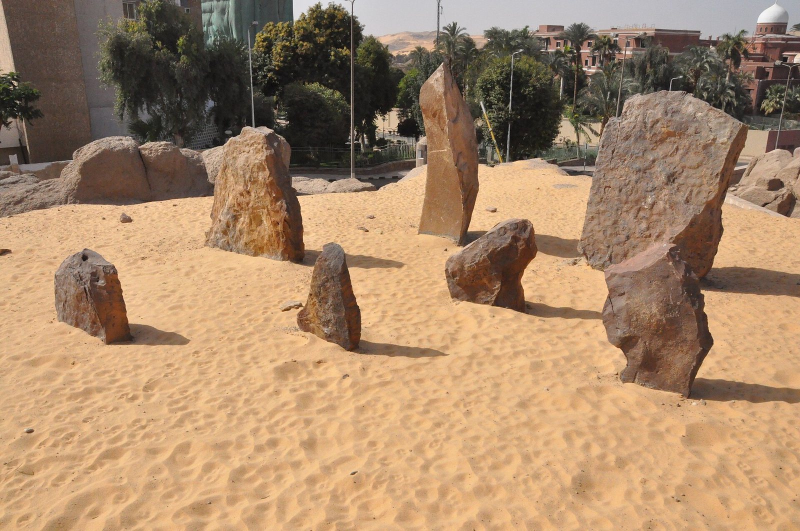
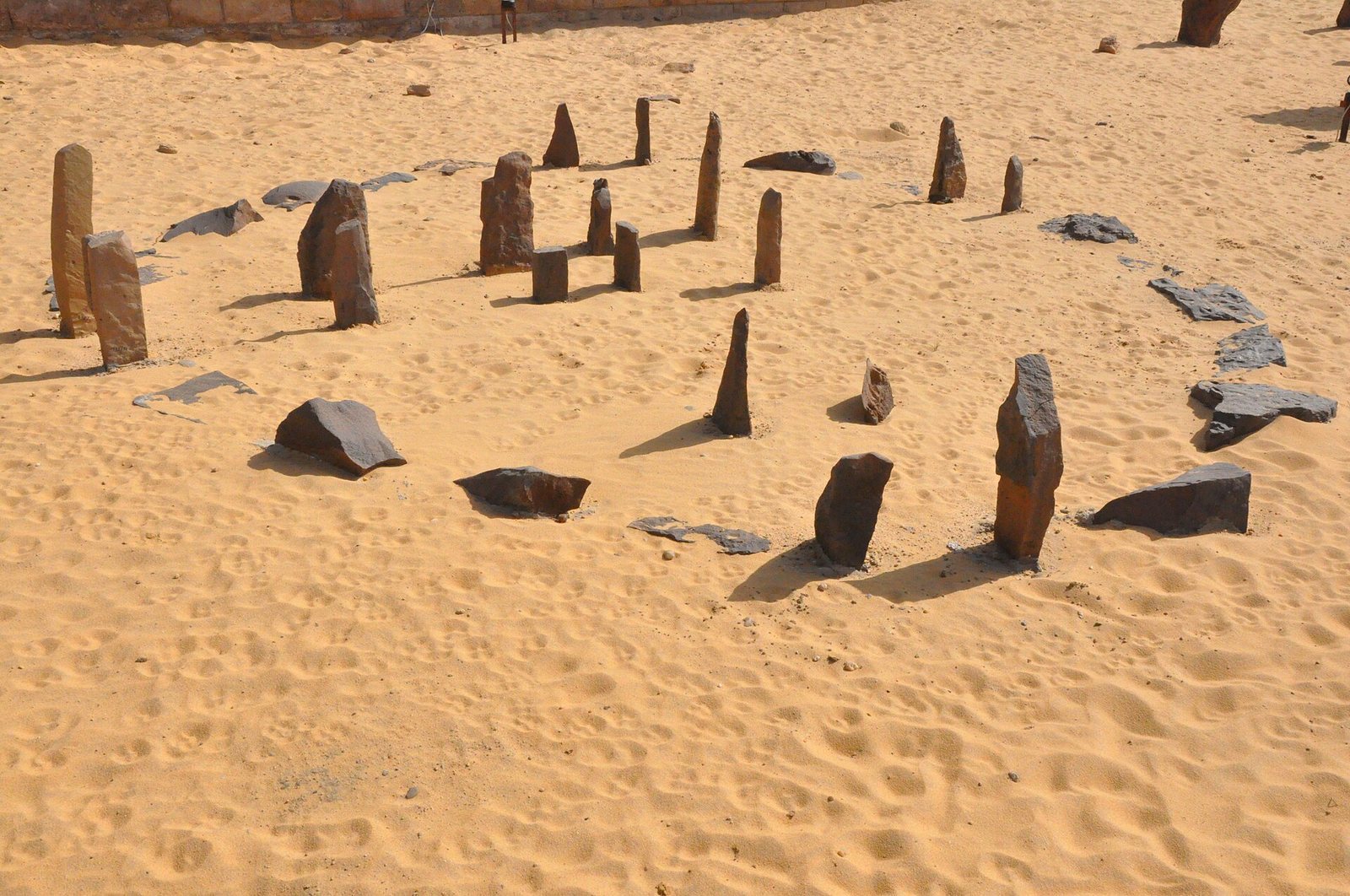
Unauthorized visits and alterations threatened fragile monuments. After Robert Bauval campaigned with UNESCO and Egyptian authorities for their protection, Egypt’s Supreme Council of Antiquities removed the stone circle and a group of large stones on 18 February 2008. The circle was reconstructed at the Nubia Museum in Aswan, while a replica marks its former location at Nabta Playa.
Remains
The archaeological landscape extends for about 2 km along the basin’s western edge and includes settlements, burial mounds, a stone circle, complex stone monuments, quarries, and lines of standing stones. Nabta Playa lies in a closed basin with no outlet to the sea. Its flat floor, or playa, once held a temporary lake, fed by runoff from an area of about 1,500 square km. Fossil shorelines and river-sand deposits preserve evidence of changing water levels, while wind erosion helped shape the basin.
Settlements and material remains
Wells and huts
Settlements included deep wells and huts arranged in roughly straight rows. Some larger communities had as many as 18–20 substantial round or oval huts, positioned to define open circulation space. The wells and buildings formed the settled parts of a landscape also used seasonally.
Food and pottery
Underground pits were used to store wild sorghum, and numerous grinding stones point to the processing of grain. Excavations recovered more than 20,000 charred plant remains from 127 species, including ten types of trees and shrubs, along with wild millets, sorghum, legumes, tubers, and fruits. Animal remains near dwellings include small game such as hares and gazelles.
Early pottery was uncommon but carefully made. Some bowls bear complex patterns of impressions on their outer surfaces, made by rocking a comb across the clay. Pottery was being produced locally by about 6800 BCE.
Burial monuments
Animal burial mounds
At least eight stone-covered mounds lie along the rocky western bank of the valley that enters the playa from the north. They contained remains of cattle, goats, sheep, gazelles, and people. One mound covered an underground chamber containing an entire young bovine. The valley, known as the Valley of Sacrifices, carried water into the playa. Its location and the animal offerings have been interpreted as possible evidence of rites intended to bring rain.
Triple stone ring and child burial
About 500 m west of the western group of large stones is a ring monument formed by three circles, about 17 m across. A burial shaft east of its center held pottery and the skull of a three-year-old child. Radiocarbon dates for the bones, calibrated to calendar years, fall around 5500–5200 BCE. The outer stones appear to have been deliberately arranged around the grave. The inner ring is irregular, and the grave’s position has been interpreted as possibly oriented toward sunrise at an equinox. A prominent feature about 1.5 km to the east may have served as a sighting point.
Stone monuments and alignments
Circular stone monument
The circular monument is about 4 m across and was built from sandstone slabs set in sand. Many slabs measure roughly 20–70 cm long, while some upright stones reach about 2 m. Fourteen slabs were thought to have stood upright, although only eight remained in position when the circle was recorded. A nearby hearth has a radiocarbon date of about 4800 BCE, but the circle’s own age is uncertain.
Descriptions of the circle differ on the number of paired stones forming its gate-like openings. An inventory made after its removal identified five pairs; the first description identified four. Two rows of stones inside the circle are also present, with their purpose uncertain. One axis runs approximately north–south, while another has been interpreted as pointing toward sunrise at the June solstice, near the start of the rainy season. The nickname "calendar circle" should be treated cautiously: the openings and distances between them do not allow accurate calendar measurement. Other proposed readings include sightlines toward Sirius or the summer solstice. A suggested arrangement representing Orion’s stars is considered unconvincing, and the proposed sky alignments remain interpretations rather than established functions.
Complex stone structures
South of the Valley of Sacrifices, a field of complex stone structures has been dated broadly to about 4500–3600 BCE. One group includes four structures and around 30 upright slabs or standing stones across an area about 500 m long and 200 m wide. It lies on an old beach deposit about 1 km south of the principal mound group. Each oval arrangement measures roughly 5 by 4 m and faces slightly north of northwest; one or two large slabs lie horizontally at its center.
The structures were built over quartzite, a hard rock formed from sandstone, shaped by erosion before the beach sediments accumulated. The rock formations lie beneath thick clay and silt, with their tops about 2–3.5 m below the surface. Two structures were excavated, another was examined with a probe, and drilling was carried out at two more.
In one excavated structure, builders dug through about 2.6 m of playa deposits to expose a hard sandstone bedrock mass. Its oval surface measures about 3.3 by 2.3 m, with its long axis slightly west of north. The north and west sides were shaped, and the top appears to have been smoothed. A second stone, weighing about 2–3 tonnes, was placed over its center. Carefully shaped with a projection resembling a head, it lies approximately north–south and is held upright by two large slabs at its northern end. It may have represented a substitute sacrificial cow and has been proposed as perhaps among Egypt’s oldest known sculptures.
Large-stone lines and quarry
Six lines of large stones extend eastward into the basin from the broader monument complex. Together they contain 26 stones. Of the 19 with reliable weight measurements, the average is about 2.6 tonnes, and the heaviest reach about 12 tonnes. One prominent line consists of nine quartzite blocks, averaging about 3 by 2 by 0.5 m, with some reaching 4 by 3 m. The blocks stood roughly 100 m apart along a line about 600 m long, divided into three shorter sections.
A nearby quarry supplied stones for the monuments, and dozens of additional sandstone blocks were stored about 100 m east of it. Some lines have been interpreted as pointing toward bright stars, including Arcturus, Sirius, Alpha Centauri, and stars in Orion’s Belt. They may instead, or also, have aided navigation or carried symbolic meaning; their intended targets are uncertain. Later examination questioned whether one prominent line was originally aligned, since its stones rest on the sides and tops of dunes.