Morgantina Archaeological Area: A Sicel, Greek, Hellenistic, and Roman City in Sicily

Site at a Glance
- Rating
- 4.2
- Popularity
- Low
- Country
- Italy
- Primary era
- Classical
- External website
- Open
- Eras represented
- Bronze Age, Classical
- Civilizations
- Ancient Greek, Roman
- Site type
- City
On this page24 sections
History
Morgantina Archaeological Area is the remains of a Sicel and Greek city in Italy, on the Serra Orlando ridge and neighbouring Cittadella hill near Aidone in central-eastern Sicily. Occupied from the Early Bronze Age through the Roman era, the settlement developed through successive indigenous, Greek, Hellenistic, and Roman phases before urban life ended through gradual abandonment around the turn of the era and no later than the first century CE.
Early settlement and the Morgetes
The earliest occupation dates to approximately 2100–1600 BCE, when a village of circular and rectangular huts stood on Cittadella. Its material culture is associated with the Castelluccio and later Thapsos cultures, and Mycenaean and Submycenaean pottery was also found there. The hill remained the oldest principal urban nucleus of Morgantina.
Ancient traditions attributed the city’s foundation to the Morgetes, an immigrant population from southern Italy led by King Morges. According to this tradition, they established the settlement on Cittadella in the tenth or eleventh century BCE, remained there for more than three centuries, and prospered through agriculture in the Gornalunga plain. The tradition preserves the memory of an indigenous community whose settlement preceded the later Greek city.
Greek arrival and early destruction
Chalcidian Greeks from Catania reached Morgantina through the Simeto and Gornalunga valleys around the middle of the sixth century BCE. They lived alongside the earlier inhabitants, and funerary assemblages contain mixed cultural elements that indicate interaction between the communities. Local religious practices were incorporated into Greek worship. The indigenous Mother Goddess was identified with Demeter and Persephone, Greek goddesses associated with agriculture, fertility, and the cycle of life and death. Archaic acroliths, partly stone statues with durable exposed parts and perishable bodies, reflect this religious transformation.
Morgantina was apparently destroyed for the first time by Hippocrates, the tyrant of Gela, late in the sixth century BCE. In 459 BCE, Ducetius, a leader of the Sicels who organized a revolt against Greek domination in central Sicily, captured and destroyed the city. The earlier urban centre was probably then abandoned as a residential settlement, although activity continued through later phases on the site.
Control by Syracuse and the refoundation
After Ducetius was defeated, Morgantina entered the sphere of Syracuse. In 424 BCE it was transferred to Kamarina in exchange for money. Dionysius I of Syracuse captured the city in 396 BCE, and Morgantina later supported the Punic army led by Magon during the conflict between Dion, a Syracusan military and political leader, and Dionysius II, the tyrant of Syracuse and Dion’s relative.
Around 340 BCE, Timoleon, a Corinthian military and political leader who reorganized parts of Sicily after the removal of tyrants, took control of the territory and rebuilt Morgantina on Serra Orlando. The refoundation introduced new fortifications, an orthogonal urban plan, a sanctuary of Demeter and Persephone, an assembly building known as an ekklesiasterion, and a bouleuterion, the meeting place of the city council. Greek settlers increased the population after the refoundation.
In 317 BCE, Morgantina supplied Agathocles, the Syracusan ruler, with 1,200 soldiers for his seizure of Syracuse. The agora, the principal public square of a Greek city and a centre for political, administrative, commercial, and social activity, was created or developed during this period. The city reached its greatest prosperity in the third century BCE, particularly during the long reign of Hiero II of Syracuse, whose rule lasted from 275 to 215 BCE. Morgantina may then have had approximately 10,000 inhabitants and was one of the major inland centres of Sicily.
Roman conquest and abandonment
During the First Punic War, Morgantina was aligned with Rome through the Syracusan kingdom of Hiero II. After Hiero’s death during the Second Punic War, the city transferred its allegiance to Carthage, expelled the Roman garrison, and became an operational base for the Siculo-Punic alliance, the political and military sphere formed through interaction between Sicilian communities and Carthage. Punic and Syracusan forces took refuge within its fortified walls.
Morgantina continued to resist after the fall of Syracuse in 212 BCE. In 211 BCE, Marcus Cornelius Cethegus besieged and destroyed the city, then gave it to Mericus and his Spanish mercenaries as a reward for their assistance in the Roman capture of Syracuse. After the conquest, Morgantina was reduced and gradually transformed into a Roman oppidum, a town or fortified settlement. The Romans reused public buildings as shops and food establishments, while agricultural production and the manufacture of terracotta continued.
The city was involved in the First Servile War, a major slave revolt in Roman Sicily during the second century BCE. Diodorus Siculus records that Eunus, the revolt’s leader, was held prisoner at Morgantina in 135 BCE. During the Second Servile War, dated 105–101 BCE, the city was besieged and possibly captured temporarily by rebels led by Salvius. Morgantina may later have supported Sextus Pompey in his struggle against Octavian. Strabo subsequently listed it among the cities that had disappeared, while archaeological evidence indicates that abandonment proceeded gradually around 30 BCE.
Rediscovery and archaeological investigation
The remains were first identified in the late nineteenth century by Paolo Orsi, who initially interpreted the city as ancient Herbita. Bronze coins and the agreement between the archaeological evidence and historical accounts led to its identification as Morgantina. Excavations began with Luigi Pappalardo in 1884, when part of a necropolis, a large terracotta drain, and two houses were uncovered. Orsi recorded finds and excavated trial trenches in 1912.
A major excavation campaign began in 1955 under Princeton University, directed by Erik Sjöqvist and Richard Stillwell. Later work involved American, Italian, British, and Scandinavian institutions and revealed much of the urban centre, although substantial areas remain unexcavated. Hubert L. Allen later administered the excavations, and the University of Illinois became a co-sponsor. Malcolm Bell III took responsibility for the project in 1978, while Carla Antonaccio assumed responsibility in 1990 for publishing the post-seventh-century BCE settlement on Cittadella. Excavations and research continue, including work on the North Baths since 2003.
Sweden’s King Gustaf VI Adolf visited Morgantina several times in the 1950s at the invitation of Erik Sjöqvist and participated in work at the site. Excavation and research have established the settlement’s prehistoric, indigenous, Greek, Hellenistic, and Roman phases. The archaeological park covers more than 3 square kilometres, while the excavated archaeological zone covers more than 20 hectares.
Objects removed from Morgantina, including the so-called Goddess or Venus of Morgantina, the Head of Hades, the acroliths, and the Morgantina Treasure, were involved in restitution disputes with American museums and were returned to Italy. The returned works are displayed at the Archaeological Museum of Aidone. The museum occupies a seventeenth-century former Capuchin monastery and houses excavated material from Morgantina ranging from prehistoric to later periods.
The Morgantina Treasure comprises 15 silver objects made in the third century BCE and discovered accidentally near the House of Eupolemos. It may have been concealed during the Roman sack of 211 BCE, and some scholars have attributed it to the hierophant, the chief priest of Demeter and Persephone. After its return to Italy in 2010, it was temporarily displayed in Rome and then assigned permanently to the Sicilian regional authorities. Morgantina’s coinage, issued from the fifth to the second century BCE, records Greek, Sicelo-Punic, and Iberian or Spanish-mercenary phases, including coins marked SIKELIOTAN and HISPANORUM. Its agricultural economy included grain, oil, and wine, while the grape variety known as vitis murgentina was associated with the city and later cultivated in mainland Italy.
Remains
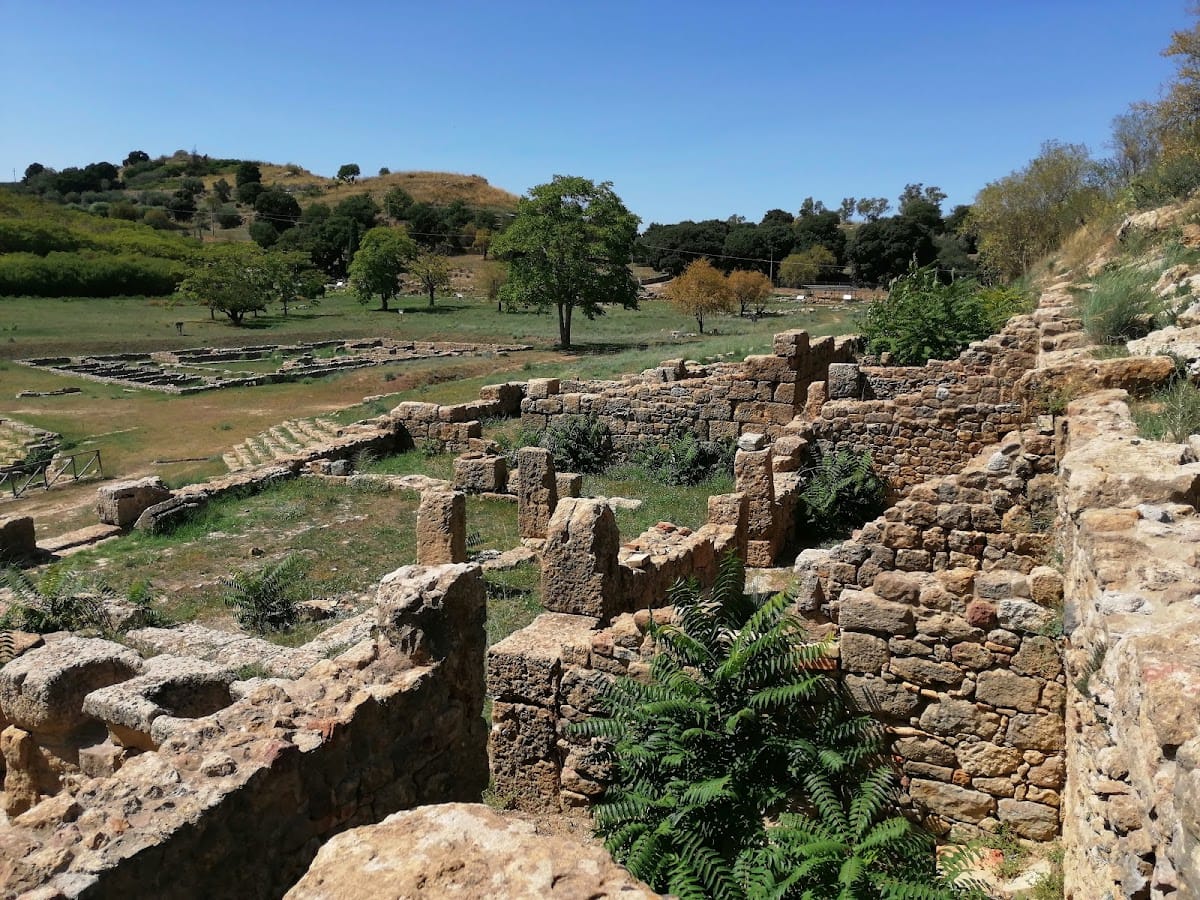
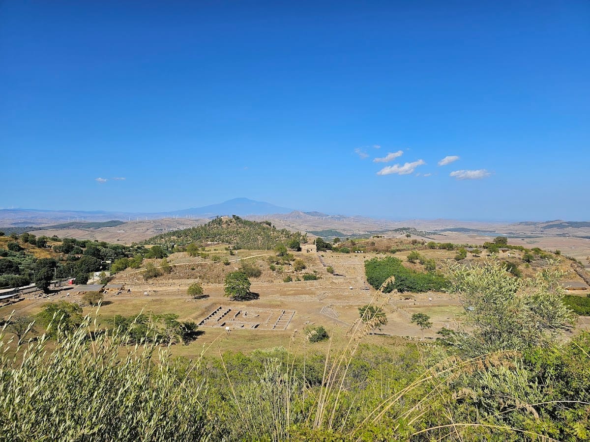
Morgantina occupies an elongated, undulating ridge approximately two kilometres long, oriented southwest to northeast above the Gornalunga plain. The site includes the older settlement on Cittadella and the later city on Serra Orlando, whose streets follow an orthogonal plan. A partly excavated residential quarter is arranged in equal-sized blocks measuring approximately 110 by 37.50 metres. The ridge’s position controlled routes between eastern Sicily and the island’s interior.
Cittadella settlement
Acropolis and early remains
The Cittadella acropolis lies about one kilometre east of the Hellenistic city and occupies terraces on the northern and western sides of the hill. The eastern slope contains rock-cut chamber tombs and sections of fortification walls formed by two parallel stone faces with an earthen fill. The hill preserves the Bronze Age hut village, parts of an archaic acropolis destroyed in 459 BCE, a circuit wall, Greek-type cult buildings, a public area, and a necropolis with chamber tombs.
An elongated temple stands on the summit. Its precise date is uncertain, but it belongs to the early historical phases of the settlement. Together with the terraces, fortifications, public area, and burial chambers, it reflects the development of Cittadella as the first principal urban centre before the later city was laid out on Serra Orlando.
Agora and civic buildings
Squares and porticoes
The public centre of the later city was the agora, arranged beside a broad paved central street. Differences in natural elevation divided it into an upper square to the north and a lower square to the south. Porticoes, public buildings, and civic spaces surrounded the two levels. The northern side was bounded by a portico approximately 90 metres long, identified as a gymnasium, a Greek institution for physical training and education. Service rooms, including changing rooms and washing basins, opened onto it. The building dates to the third century BCE and was constructed during the reign of Hiero II.
The eastern side preserves the foundations of another portico approximately 87 metres long. Its multifunctional building may have served popular justice, education, and sheltered meetings. Shops and another long portico bordered the western side, although the latter survives only poorly. A monumental fountain, or nymphaeum, stood at the eastern end. Associated with water and the Nymphs, it had two basins, a broad approach stairway, and columns decorated with Doric friezes. Excavated between 1982 and 1984, it was probably built in the second half of the third century BCE and was violently destroyed, possibly by an earthquake, late in the first century BCE.
Bouleuterion and assembly stairway
The bouleuterion stood at the northern end of the eastern portico. Its bipartite plan included a semicircular interior wall and a rectangular podium that supported the council’s seating. Foundations and parts of the southern side of the auditorium survive.
A trapezoidal stairway connected the upper and lower agora. Its eastern end was left unfinished, and the structure also served as the ekklesiasterion, the space where the popular assembly met to make major decisions. The combination of circulation and assembly functions reflects the civic organization of the Hellenistic city.
Macellum and industrial buildings
The upper agora contains a Roman macellum, a market building organized around stalls and a courtyard. Built in the first half of the second century BCE, it followed a different orientation from the Hellenistic buildings. Thirteen equally sized shops stood along the northern and southern sides of a porticoed courtyard, with a circular shrine-like structure at the centre. A pre-existing Greek sacred area with a large rectangular altar was incorporated at the western entrance.
The principal public granary stood beside the eastern side of the lower agora at the foot of the hill. Strong buttresses supported its perimeter walls, and a continuous series of storage rooms held agricultural produce and possibly taxes collected first for Syracuse and later for Rome. A well-preserved kiln stands at its northern end. A larger kiln at the southeast corner of the agora occupied a broad passage divided by arches and produced architectural terracottas, including bricks and aqueduct pipes.
Theatre and waterworks
Theatre
The theatre borders the western side of the lower agora and rests against the western hill. It was initially trapezoidal, probably in the mid-fourth century BCE, and was later rebuilt with a horseshoe-shaped cavea, the tiered seating area, between the end of the fourth and the beginning of the third century BCE. Two side passages lead to the orchestra, the performance space traditionally used by the chorus. The theatre also had a fixed stage façade and arrangements for movable scenery supported by wooden beams.
The cavea contains approximately 15 rows divided into sectors and is supported by a retaining wall of carefully dressed stone blocks. The theatre was dedicated to Dionysus, whose name appears on the riser of one step. Its acoustic effect remains appreciable. Nearby, a terracotta water conduit made from interlocking elements preserves an elliptical inspection opening.
Sanctuaries and civic religious spaces
Sanctuary of Demeter and Persephone
On elevated ground beside the theatre stood the principal sanctuary of Demeter and Persephone, the city’s patron deities. Entered from the west, it was divided into northern and southern sectors arranged around separate courtyards. The northern sector included a purification basin, a small offering room, rooms around a large paved courtyard, and facilities for worshippers. A well-preserved kiln in its northeast corner produced terracotta votive objects.
The southern cultic sector centred on a large cylindrical altar that retains traces of its original plaster. Beside it lies a bothros, a sacred pit used for offerings and libations, especially in rites directed toward underworld deities. It was enclosed by a low circular wall, and numerous lamps found there were probably associated with nocturnal rites. Exedrae with seats, a smaller opposing exedra, and a small shrine were arranged around the altar courtyard. A second sacred enclosure, or temenos, lies south of the sanctuary and has a trapezoidal plan.
Prytaneion
The prytaneion stood on the eastern hillside above the public square. This civic building was associated with the chief magistrate and the community’s sacred fire. Its several rooms surrounded a broad courtyard paved with terracotta. Three recessed stone blocks held large storage amphorae, and the base of a domestic oven also survives.
Residential quarters
Eastern hillside houses
The eastern residential quarter includes the House of the Doric Capital, also called the House of the Greeting because of a welcome inscription on its floor. Its rooms were arranged symmetrically around a central peristyle, a courtyard surrounded by columns, which provided light and collected rainwater in two cisterns. The columns were made from specially shaped ring-like bricks, a cost-saving technique used where suitable local stone was unavailable. Floors of cocciopesto, a durable paving material containing crushed terracotta, carried geometric designs in white stone tesserae.
The House of Ganymede has a large rectangular peristyle with fluted columns and Doric capitals. Two small rooms retain reconstructed red-painted wall plaster and third-century BCE mosaic floors. One mosaic depicts the abduction of Ganymede; the other shows a perspective meander, a knotted ribbon, and ivy leaves associated with victory in athletic or literary competition. The house belonged to the period of Hiero II and was reused after the Roman conquest. A wall crossing the peristyle later divided it into two parts.
Western hillside houses
A second residential quarter on the western hillside is incompletely excavated. Its regular streets are bordered by narrow drainage channels for rainwater. The House of the Magistrate contains 24 rooms and probably belonged to one of the city’s governors. A private northern sector was separated from a representative southern sector containing a porticoed courtyard, an atrium preceded by two columns, and a large square dining room capable of accommodating nine klinai, reclining couches used at receptions and banquets.
A narrow corridor led from the atrium to the private sector, where a second peristyle distributed the surrounding rooms. During the Roman period, the house was subdivided and occupied by a potter. The potter’s intact kilns remain visible in the northwest corner. A paved central street approximately 6.40 metres wide runs west to east through the quarter and divides it into two sectors.
Houses of the central residential blocks
The House of the Tuscan Capitals occupies several levels and was remodelled during the first century BCE with architectural elements of Italic tradition. It includes a four-column courtyard forming a monumental atrium and a long, narrow peristyle. The Southwest House is arranged around a 12-column peristyle. Its south-facing reception area comprises a central room of approximately 35 square metres and two symmetrical side rooms, all paved with refined cocciopesto decorated with white-tessera meanders and multicoloured stars.
The House of the Shops was converted during the Roman period by inserting several tabernae, small commercial or workshop units, each with a sales room and a rear storage room. The House of the Palmento preserves a room used for oil production. The House of Pappalardo has a 12-column peristyle, mosaic floors, and an area of approximately 500 square metres. Dating to the middle of the third century BCE, it also preserves the end of the sewer channel serving the entire block along its eastern perimeter wall.
Houses with distinctive finds
The House of the Forty-Four Gold Coins contained a hoard of coins issued by Philip II of Macedon, Alexander the Great, Agathocles, Icetas, and Pyrrhus, dating from the fourth to the third centuries BCE. The House of the Arched Cistern occupies part of a northern residential block. Its rooms are arranged around two peristyles and include mosaic floors. The large reception room, or tablinum, retains reconstructed painted plaster and a mosaic floor. Its western wall preserves the opening of a cistern with a stone-vaulted roof and a terracotta basin.
Stair remains indicate that the House of the Arched Cistern, like several other Morgantine houses, had a second storey. The less elaborate House of the Antefixes and Southeast House complete the block. Several houses contain mosaics, painted plaster, peristyles, cisterns, drainage channels, workshops, and ovens. Family hand mills made from two interlocking volcanic-stone elements were found among the household furnishings, and examples are displayed at the entrance to the archaeological park.
Baths
The North Baths form a third-century BCE complex with evidence considered among the earliest known examples of dome and barrel-vault construction. Their remains add to the public and domestic evidence for the city’s architectural development during its Hellenistic prosperity.