Limbaži Medieval Castle: Residence of the Archbishops of Riga in Latvia


Site at a Glance
- Rating
- 4.6
- Popularity
- Very Low
- Country
- Latvia
- Primary era
- Medieval
- Eras represented
- Medieval
- Civilizations
- Crusader, Holy Roman Empire, Livonian Order, Polish–Lithuanian Commonwealth
- Site type
- Military
- Remains
- Castle
On this page13 sections
History
Limbaži Medieval Castle is a ruined former residence of the archbishops of Riga in Limbaži, Latvia. It belonged to the northwestern, Livonian part of the Archdiocese of Riga, an archbishop-led ecclesiastical territory, and was probably built around the early fourteenth century. The castle was first mentioned in 1318, when the Livonian Order, the regional branch of the military order commonly known as the Teutonic Order, briefly occupied it. A foundation date of 1223 is also cited, although supporting evidence for that date has not been established.
Archiepiscopal residence and Livonian conflicts
The castle stood near the earlier Livonian stronghold of Lemesele, on a hill approximately 250 metres to the northeast. Its historical names included Lemsal and Lemselle. Within the Archdiocese of Riga, it served as the archbishops’ residence for the northwestern, so-called Livonian part of the territory, while Ronneburg served the corresponding role in the archdiocese’s Latvian part.
Relations between the archbishop and the Livonian Order remained tense. The Order occupied the castle again for short periods in 1359 and 1479. In the sixteenth century, the castle was described as the archbishop’s “spring residence.” He stayed there with a retinue of about 800 people from Candlemas, on 2 February, until Pentecost at the end of May.
Lemsal, war, and decline
The town of Lemsal developed around the castle and became an early member of the Hanseatic League, a commercial network of towns and merchant communities around the Baltic and North Seas. With approximately 20,000 inhabitants, it was Livonia’s second-largest city after Riga. Its prosperity depended on tolls charged to merchant ships using the navigable Svētupe between Lemsal and the Baltic Sea.
Lemsal began to decline during the first half of the sixteenth century as the Svētupe silted up. Fewer merchant ships could then reach the town harbour. During the Livonian War, the sixteenth-century conflict over control of Livonia, Russian troops destroyed and burned the castle and town in 1558 and 1575. Swedish troops carried out the same destruction in 1567.
After the war, Poland-Lithuania took control of Lemsal as part of the secularized Duchy of Livonia and rebuilt the castle and town. Swedish troops captured the castle in 1602 during the Polish-Swedish War and demolished its outer fortifications. On 19 November 1621, King Gustav II Adolf of Sweden granted the castle and its associated lands to the city of Riga. The castle subsequently fell into decline.
Ruins and archaeological intervention
Measures to secure the surviving ruins began in 1968, when the remains were surveyed and photographed. In 1999 and 2000, an excavator dug up a large area behind the outer wall. This work caused substantial damage to the archaeological cultural layer, the accumulated deposits containing evidence of earlier activity.
Remains
Setting and defensive layout
The castle occupied a low hill. A stream bordered it on the north before flowing into Dūņezers, the lake west of the castle. The Svētupe rose from this water system and reached the Baltic Sea at Svētciems. The northern stream was dammed to create two ponds east of the castle, and at least the northern pond served as a millpond.
Main castle
The principal castle generally followed the plan of a rectangular, at least three-winged convent castle, a fortified residence arranged around a central courtyard. This layout closely resembled early Livonian Order castles. The southeast wing survives for its full length and measures approximately 29 metres long by 10 metres wide. The dimensions of the northeast and southwest wings remain uncertain. Estimates describe either a roughly square plan with sides of about 30 metres or a castle approximately 28 metres wide and about twice as long.
Outer defenses
An outer bailey system occupied an approximately 15-metre-wide strip around the main castle. It was formed by parcham walls, an outer defensive wall or rampart system separated from the main fortification. The Teutonic Knights had adopted this type of defense from Byzantine fortification practice during the Crusades, and the walls were probably expanded during the Livonian Order’s occupation of Lemsal. Beyond them lay a water-filled moat and an outer rampart.
The town lay south of the castle and was enclosed by its own town wall and moat. The moat apparently also separated the town from the castle, adding another boundary between the settlement and the main fortress.
Gates and towers
The principal gate stood centrally in the northeast wall. It had an externally mounted portcullis with two openings and a wall niche probably intended for a statue of a patron saint. A second entrance was placed in the same wall near the eastern corner. A drawing from 1795 shows the remains of a portal in front of the main gate, probably within the forward parcham wall.
A massive square tower occupied the northern corner, while a stair tower stood at the western corner. Both can now be identified only through their foundations. Several historical views show a round tower, but this does not correspond to the discovered square foundation and may represent the foundations of an earlier predecessor tower.
Wings, rooms, and construction
Surviving wings
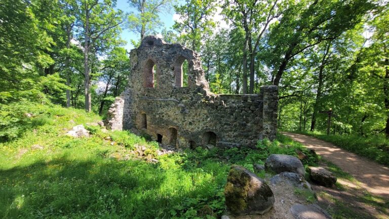
The southwest wing was replaced by a barn in the eighteenth century, although the barn itself no longer survives. All the building wings still had roofs until shortly before the Second World War. It has not been established whether a northwest wing existed. The castle may instead have had a U-shaped plan, with its northwest side closed only by a connecting castle wall.
Interior spaces
The functions of the individual rooms remain uncertain. The southeast wing may have contained a representative hall, while the northeast wing may have housed a chapel. Both spaces retain traces of vaulted ceilings. The cellar served for storage.
Walls and materials
The castle walls were built from partly dressed fieldstones bonded with lime mortar. They are approximately 1.8 to 2 metres thick. Brick was used only in limited areas, including the arches over the windows and the main gate.
Nearby sites