Küssaburg: A Medieval Summit Castle and Territorial Fortress in Germany
Site at a Glance
- Rating
- 4.3
- Popularity
- Low
- Country
- Germany
- Primary era
- Medieval
- External website
- Open
- Eras represented
- Medieval, Early Modern
- Civilizations
- Holy Roman Empire
- Site type
- Military
- Remains
- Castle
On this page19 sections
History
Küssaburg is a ruined medieval summit castle in Germany, probably built between 1125 and 1141 by the counts of Küssenberg in the period of the Holy Roman Empire. It stands at Bechtersbohl, within the municipality of Küssaberg, and controlled routes linking the Swiss Alpine foreland, a Rhine crossing, and the Klettgau, a historic landscape around the present German-Swiss border.
Early occupation and the counts of Küssenberg
The hill may have been used for defence before the medieval castle. A Bronze Age flanged axe found during water-pipeline construction points to early activity, while the steep slopes and the narrow eastern approach have led to the interpretation that a Celtic hillfort may once have occupied the summit. During the Roman period, a watch and signal tower may have guarded the road between Tenedo, near Bad Zurzach, and Juliomagus, near Schleitheim. A Roman estate associated with a person named Cossinius has also been proposed as the source of the names Küssaburg and nearby Küßnach.
The earliest written reference to a castle on the Küssenberg dates to 888 and appears in the archive of Rheinau Abbey. The counts of Küssenberg are first recorded in 1135 and 1150, shortly after the probable construction of the present castle. They became an important noble family in the Klettgau. In 1172, the Landgraviate of Stühlingen passed by inheritance to the lords of Küssenberg, and Werner of Küssenberg served as abbot of St. Blasien from 1170 to 1178.
The region had earlier been shaped by the decline of Roman authority and the expansion of Alamannic settlement. After the Frankish victory over the Alamanni at Zülpich in 496, Alamannia was gradually incorporated into the Frankish realm. Under the Carolingians, it became a province divided into administrative districts, and counts replaced the older ducal office. Küssaburg later belonged to the territory associated with Küßnach and formed part of the network of powers competing for control of the Klettgau.
Episcopal lordship and regional competition
In the late twelfth and thirteenth centuries, the Küssenbergs and Krenkingers competed for influence in the Klettgau. The Bishopric of Constance, an ecclesiastical principality in which the bishop exercised both religious and territorial authority, acquired the Küssenberg lordship in 1241 under Bishop Heinrich of Tanne. The acquisition included the castle and its associated settlements.
Around 1250, the male line of the counts of Küssenberg ended. The lords of Lupfen inherited the Stühlingen portion of the former territories, while the bishopric retained Küssenberg. Under Constance, the territory became the small lordship known as “Küssaburg Castle and Valley,” comprising Bechtersbohl, Küßnach, Dangstetten, Rheinheim, and Reckingen.
Later struggles involved the Bishopric of Constance, the counts of Habsburg-Laufenburg, and the developing city-state of Schaffhausen. The Swiss cantons also became involved in these disputes. In the early fifteenth century, the Klettgau passed by marriage to the counts of Sulz. After prolonged disagreements involving Schaffhausen and Constance, a settlement in 1497 awarded Küssaburg and its lordship to the Sulz family.
The foreburg and the Swiss War
The castle’s outer settlement, or foreburg, accommodated retainers, dependants, and serfs. Its inhabitants appear in records from 1317 to 1494. In 1346, Bishop Ulrich I granted the foreburg the right to maintain its own local magistrate and priest, giving the settlement a defined administrative and religious role within the lordship.
During the Swiss War of 1499, the garrison surrendered on 20 April after the Confederates positioned a large gun before the main gate. The defenders were permitted to leave with their personal possessions. Troops commanded by Heini Ziegler of Zurich then occupied the castle, which was returned to the count of Sulz in October 1499 under the Peace of Basel.
Fortification under the counts of Sulz
The damage caused by the Swiss War encouraged Rudolf V of Sulz to develop Tiengen as his principal residence. In 1523, Archduke Ferdinand I granted him funds to expand the fortifications at Vaduz and Küssaburg. In return, imperial troops received permanent access, linking the castle’s future to wider Habsburg military interests.
During the German Peasants’ War, a major uprising of rural communities against political, economic, and feudal grievances, Küssaburg was commanded by Wolfgang Herrmann of Sulz. Klettgau peasant forces made unsuccessful attempts to take the castle in June and October 1525. After their defeat on the Rafzerfeld on 4 November, about 100 captured peasants were brought to Küssaburg. The peasant commander Klaus Wagner was mutilated and blinded there. Hans Rebmann, a Zwinglian Reformed preacher, was also blinded after imprisonment at the castle.
The communities of the Klettgau were additionally required to surrender their largest church bells. These were melted down and recast as guns for the fortress. After the uprising, Austrian financial support enabled Küssaburg to develop into a territorial fortress designed for artillery warfare. Disputes over its mortgage and ownership involved Constance, the Sulz family, the margrave of Baden, and Zurich. An imperial settlement in 1575 converted the arrangement into a feudal mortgage held by the Bishopric of Constance. The castle and Tiengen were to return to the bishopric after the direct Sulz-Brandis line became extinct.
Destruction and abandonment
In 1595, Count Rudolf VII of Sulz imprisoned the alchemist Leonhard Thurneysser at Küssaburg after his arrest in Tiengen. Thurneysser obtained his release through friends but had to leave some of his books at the castle. At least one later entered the library of St. Gall Abbey.
The Thirty Years’ War, the European conflict of 1618 to 1648 that combined religious, dynastic, and territorial struggles, brought renewed military change to the High Rhine. In 1633, French troops serving under Swedish authority expelled imperial soldiers from Küssaburg. The French withdrew on 18 October, allowing imperial forces to reoccupy the castle.
On 8 March 1634, the imperial garrison set Küssaburg on fire and abandoned it. Tradition connected the destruction with the approach of the Swedish army under Gustav Horn, but that army was then in winter quarters at Pfullendorf. Later research instead associated the event with an advancing Swedish-allied force of about 800 lightly armed soldiers under Major General Bernhard Schaffalitzky. The garrison may have burned the fortress to prevent its capture and use as a link between Stühlingen and the Protestant canton of Zurich.
Küssaburg was not rebuilt after the war. Plans for reconstruction considered after the Peace of Westphalia in 1648 were abandoned because the fortress was no longer economically viable or strategically important. The ruins gradually deteriorated, and from the period after the fire until the middle of the nineteenth century, their stone was quarried for the Oberlauchringen mill, the church at Schwerzen, a way of the cross in Tiengen, and farm buildings near Küssaburg.
Preservation and archaeological work
A landslide recorded on 25 December 1664 was traditionally linked with further damage to Küssaburg. Geological research later placed the landslide about two kilometres east of the castle and concluded that it did not damage the ruins.
After the male Sulz line ended, the Klettgau passed through the marriage of Maria Anna of Sulz to Ferdinand of Schwarzenberg in 1703. The Schwarzenberg family retained Küssaburg until the Grand Duchy of Baden acquired the Klettgau in 1812.
Protection against further dismantling began in 1855, when legislation halted the removal of building material and regulated the opening and investigation of the ruins. A temporary entrance was created by enlarging a loophole in the eastern wall. Systematic excavations followed in 1896 and 1897, and the ruins were fully uncovered between 1932 and 1939. The Küssaburg-Bund, founded in 1893, re-established during the excavations of the 1930s, and revived in 1956, has supported the site’s care.
In 1978, ownership passed from Baden-Württemberg to Waldshut County. This enabled the Küssaburg-Bund to obtain state monument-preservation support. Later work repaired masonry and wall tops, reconstructed the gate building, and maintained the entrance drawbridge. Küssaburg is regarded as a historic monument and landmark of the High Rhine and Waldshut County. Its southern slope is also designated as the Ruine Küssaburg nature reserve.
Remains
Küssaburg occupies a summit position at about 634 metres above sea level on the southern extension of the Randen, a hill range along the German-Swiss border. The ruins stand on the westernmost Jurassic limestone summit of the Klettgau Randen, overlooking the Klettgau and High Rhine valley toward the Southern Black Forest and the Aargau. The castle commands the Bechtersbohl saddle and its pass. A Roman military road between Italy, the central Alps, and Germania passed at the western foot of the hill, while the route through Bechtersbohl continued toward the Klettgau.
Outer defenses and entrance
The foreburg
The fortified foreburg occupied a plateau in front of the main castle. A ring wall enclosed the outer settlement together with the main complex, and sections of this wall survive on the southern side. The foreburg was partly destroyed during the Peasants’ War. During the rebuilding after 1525, parts of it were cleared to improve the fortress’s field of fire as Küssaburg was adapted for artillery.
The gate complex
The entrance sequence includes an outer gate, an inner gate leading into the core castle, a reconstructed gate building, and a working wooden drawbridge. The present bridge was completed in 1981, its counterweight was strengthened in 1996, and the current version dates from May 2017. The structure weighs about three tons and can be operated manually.
The former shield wall has been adapted as a viewing tower. The entrance coat of arms is a modern reconstruction made in 1983 by the sculptor Ernst Keller from a design by Ernst Wellenreuther. It replaced an earlier heraldic stone associated with the counts of Sulz and the Bishopric of Constance, which was reportedly stolen around 1847.
Core castle and construction
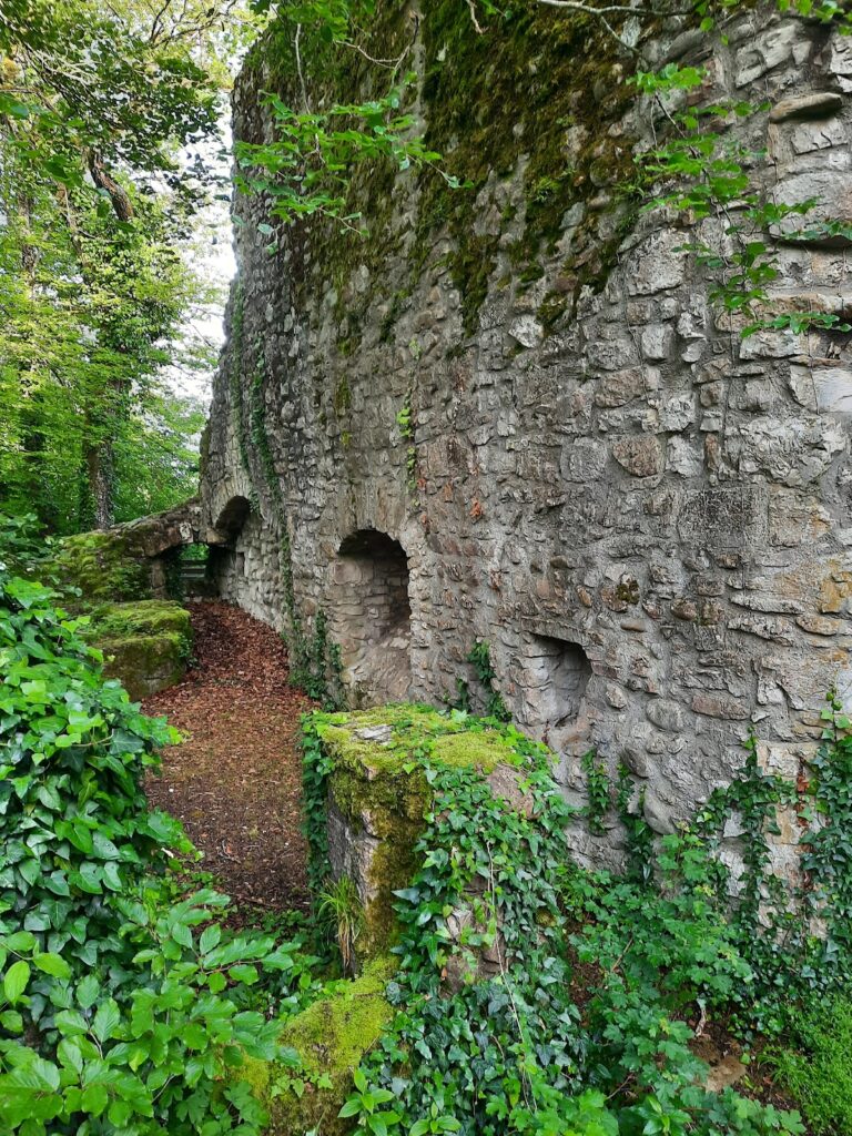
The hill consists of light-coloured White Jurassic limestone, and this hard local stone forms much of the castle masonry. Because it is difficult to shape and prone to splitting, brown sandstone from the nearby Wutach Formation was used for many stairs, loopholes, window surrounds, reveals, lintels, and the entrance coat of arms. The castle buildings originally had several storeys. The surviving complex includes towers, walls, gate structures, domestic and service buildings, a chapel area, storage facilities, and a water-supply installation.
Residential and defensive buildings
The core castle contains the remains of the palas, the principal residential hall of a medieval castle. Other surviving features include a former dungeon in the western tower, a rounded artillery fortification called a rondel in front of it, and a storage area. The former economic area retains console stones decorated with goblin-like figures. The complex was expanded into a large artillery fortress after the Peasants’ War. A traditional description assigns 136 rooms to an earlier expansion under the Bishopric of Constance, although that figure is not independently established in the surviving fabric.
Chapel and water supply
Walls identified with the chapel survive within the core castle. A well or rainwater cistern, which collected and stored precipitation for use inside the fortified settlement, formed part of the water-supply installation. Together with the storage area and service buildings, these remains reflect the arrangements needed to sustain the castle’s occupants.
Reused road stones
Two grooved stones are set within the castle masonry. They are believed to have come from the steep section of the Roman road near Bechtersbohl, where grooves helped prevent wagon wheels from skidding or leaving the road. Their reuse connects the later fortress with the earlier transport route at the foot of the hill.
Archaeological evidence and changing appearance
Earlier occupation
A heavy Bronze Age flanged axe was recovered near the castle during construction of a water pipeline. Finds and features dating from the Bronze Age through the early Middle Ages support the probability of earlier fortified occupation on the summit. A Roman watch or signal tower is suspected on the hill, while a Gallo-Roman ambulatory temple, a Roman-period temple surrounded by a passage for ritual movement, stood at the foot of the hill. Foundations of a temple probably dedicated to a Gallo-Roman goddess were excavated in the wider Klettgau area in 1996.
Fifteenth-century stove tile
Excavations in 1896 and 1897 produced a high-quality green-glazed stove tile from the second half of the fifteenth century. Found behind the gate of the palas, the square tile depicts a pair playing music beside a well. It is now held by the Baden State Museum in Karlsruhe.
Fire damage and visual records
The stones retain wine-red discoloration attributed to the fire of 1634. The ruins therefore represent chiefly the masonry that survived after the combustible wooden elements were destroyed. Images from earlier periods preserve changing views of the complex. An intact castle appears in a 1515 fresco cycle at St. George’s Abbey in Stein am Rhein, the 1548 Stumpf Chronicle, and a military map by Hans Conrad Gyger. Later views by Conrad Meyer, Johann Caspar Ulinger, Johann Heinrich Meyer, J. M. W. Turner, and Maximilian von Ring record its transition from fortified residence to ruin.
A traditional story tells of an underground passage linking Küssaburg with a small castle at the bridge of Zurzach. The tale forms part of the castle’s later local tradition.