Khirbet el-Maqatir: A Highland Settlement and Byzantine Church Complex in Israel
Site at a Glance
- Popularity
- Very Low
- Country
- Palestine
- Primary era
- Medieval
- Eras represented
- Iron Age, Classical, Medieval
- Civilizations
- Byzantine, Roman
- Site type
- Military
- Remains
- Fortified Town
On this page20 sections
History
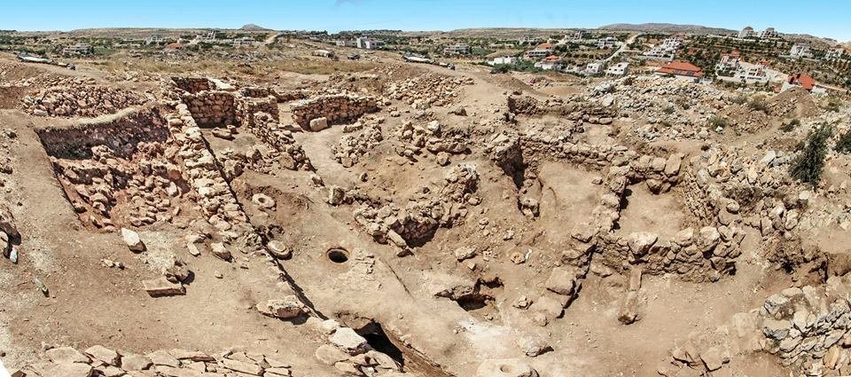
Khirbet el-Maqatir is an archaeological site between Deir Dibwan and Beitin in the central West Bank, Israel. Its history includes a fortified Bronze Age settlement, an Iron Age village, a Jewish village destroyed during the First Jewish Revolt, and a Byzantine church and monastery established on a neighboring hill. The church complex, begun in the fourth century CE, is among the earliest known in Palestine.
Bronze and Iron Age occupation
The earliest settlement was fortified and occupied during Middle Bronze Age III and Late Bronze Age I. A fire destroyed it in the later 15th century BCE, after which the site remained unoccupied for about two centuries. An Iron Age village, from a period when iron technologies became prevalent, was later established and continued through Iron Age II. Most of its recovered pottery belongs to Iron Age I.
After about 586 BCE, the village was abandoned for several centuries. This change may have followed the campaigns of Nebuchadnezzar, the Babylonian king whose conquest ended the Kingdom of Judah, and the deportation of part of Judah’s population to Babylonia.
Hellenistic and Jewish village
A small Jewish community resettled the site around 290 BCE. During the Hellenistic period, which followed Alexander’s conquests and brought Greek political and cultural influence to the region, the settlement grew into a village. Its earliest clearly identified buildings date to about 100–31 BCE. Occupation continued through the Hasmonean period, when a Jewish ruling dynasty governed Judea, and the village reached its greatest extent around 10–69 CE.
The village was destroyed in 68/69 CE during the First Jewish Revolt, a Jewish uprising against Roman rule that began in 66 CE. Roman troops of Legio X Fretensis, a Roman army legion, were advancing through the Bethel Hills toward Jerusalem. The destruction came about a year before Titus, son of the Roman commander Vespasian, captured and destroyed Jerusalem. Coins and destruction deposits place the village’s end in this period. A sharp increase in the number of coins may reflect either population growth or money hidden during Vespasian’s campaign.
Revolt and later occupation
After 69 CE, coins from the site become scarce. Finds from an underground hiding complex indicate that it was used during the Bar Kokhba Revolt, a major second-century Jewish uprising against Roman rule, around 134/135 CE, while the village itself appears to have been largely uninhabited. Archaeologist Evgeny Aharonovich has proposed that the village and nearby Khirbet Kafr Mur and Beitin resisted the Roman advance in 68/69. The site has also been suggested as the Ephraim where the Jewish historian Josephus says Vespasian stationed troops near Bethel.
Byzantine Christians established a separate church complex on a nearby hill in the fourth century CE, after centuries in which the area was largely abandoned. The complex grew over time: two apses, projecting ends of the church, were added around 400, a monastery followed around 475, and further enlargement took place in the late fifth and sixth centuries. Damage may have occurred during the Samaritan revolt of 484, an uprising against Byzantine rule. A coin hoard beneath a basilica floor points to rebuilding under Justinian I, the Byzantine emperor.
After the Muslim conquest of the Levant following the Battle of Yarmuk in 636 CE, the church complex continued in reduced use. Its western part may have served as a dwelling, an informal settlement, or a farmstead. An earthquake in 749 brought habitation at the site to an end.
Ai identification and archaeological investigation
In 1838, residents of Taybeh identified the site to Edward Robinson as the biblical city of Ai. Robinson recognized the church remains but doubted the identification. Local residents later told Ernst Sellin that the site was known as Khirbet Ai. In 1924, William F. Albright proposed nearby et-Tell as Ai, an identification that became the prevailing scholarly view. Bryant Wood has instead argued that Khirbet el-Maqatir better fits the Ai described in the Book of Joshua, citing its Bronze Age fortress, northern gate, and nearby valleys. He proposes that et-Tell was an earlier, separate Ai associated with Abraham, and that the name later transferred to the nearby fortress. Most scholars continue to identify et-Tell, rather than Khirbet el-Maqatir, as Ai.
Investigations began with measurements of the church by Victor Guérin in 1863 and Charles Wilson in 1866, followed by a plan made by Claude Conder and Herbert Kitchener in 1882. Alfons Schneider’s more detailed survey in 1934 tentatively identified the church as the Church of Jacob mentioned by the Christian scholar Jerome. A 1998 survey by Leen Ritmeyer and Michael Luddeni identified an ecclesiastical complex larger than the church earlier visitors had recorded. Bryant Wood directed limited excavations in 1998 and 1999; Scott Stripling later led work on the church, monastery, and village through 2016. Excavation stopped after the council of Deir Dibwan questioned why its permission had not been sought.
Remains
The site occupies two spurs on a limestone hill rising to about 890 m above sea level. The Byzantine complex lies on the northwestern spur, while the earlier settlements spread across lower ground to the southeast. Beitin is about 1.6 km northwest, Deir Dibwan immediately east, and et-Tell about 1 km east. Across these areas, buildings and installations preserve successive forms of settlement, religious use, farming, and storage.
Bronze and Iron Age settlements
Bronze Age enclosure
The fortified settlement covered about one hectare on the southeastern slope. Its walls were especially thick for an enclosure of this size, reaching about 4 m along the north and west sides. The northern gate appears to have contained four chambers, although much of its stone was removed in antiquity. A possible tower has been identified on the south side. An infant burial in a jar, accompanied by vessels, dates to a transition between building phases. Two scarabs and a small bronze ram’s head also came from the settlement. One scarab, made locally according to its style, supports a Middle Bronze Age III foundation; the other has been associated with the reign of the Egyptian pharaoh Amenhotep II.
Late Bronze Age I pottery and scarab evidence point to the enclosure’s destruction in the later 15th century BCE. Burned and cracked bedrock, ash, scorched pottery, and sling stones near the gate indicate a violent fire. A ridge formed by later farmers clearing stones covered and helped preserve Iron Age structures and pottery from several periods.
Iron Age village
Some houses were built into the ruined northern wall of the Bronze Age enclosure. They reused the wall’s cobble core, with partitions forming rooms against or within it. The small stone houses generally combined a broad main room with a courtyard, a plan that drew on the earlier settlement. Their utilitarian pottery was mostly coarse, poorly fired, and undecorated. Of more than 1,100 Iron Age pottery fragments, about 93 percent date to Iron Age I.
Finds include a handmade collar-rim storage jar set into a house floor, a pottery fragment marked with the Hebrew letter aleph in a script style characteristic of Iron Age II, and an Egyptian scarab bearing the name Psametik. Animal bones were dominated by sheep and goats, which together accounted for about three-quarters of identified specimens. Cattle, dogs, chickens, and donkeys were also present; hunted animals formed a small share, and pig remains accounted for less than one percent.
Hellenistic and early Roman village
Village layout and monumental tower
The Jewish village covered about 15 dunams, or 15,000 square meters, and was enclosed by a wall reported as 4–5 m thick. Its buildings were made from fieldstones of varied sizes. Doorways used partly worked or dressed stone jambs, while floors were either paved with flagstones or made of beaten earth. Most roofs were flat, using woven supports coated with mud or clay; some buildings had roof tiles. A wall pierced by openings survives to more than 1.5 m high. A stone etching appears to depict a village plan with L-shaped walls and two or three buildings, and seems to predate the monumental tower.
The tower stood beside the village perimeter wall rather than being bonded into it, indicating that it was added later. Its base measured about 30 by 16 m. It is described as the largest known tower of its era west of the Jordan River, and its footprint exceeded those of the Phasael Tower in Jerusalem and the central tower at Herodium. The interior walls reached 2.5 m thick and the outer wall 1.4 m. Built from very large stones, partly worked stones, and cobbles, the tower also contained a subterranean pit, two Herodian storage jars at floor level, and a small domed oven. Of 145 coins recovered from the structure, 92 are Hasmonean coins of the type associated with Alexander Jannaeus, a Hasmonean ruler. Their presence suggests that construction may date as early as about 80 BCE.
Central residence and bathhouse
A large central residence survives in places to a height of 1.75 m. It was renovated in the Herodian period, under Herod the Great and his dynasty, possibly after earthquakes in 31 and 27 BCE. In an early first-century CE reconstruction, earlier walls were cut down to floor level and covered by flagstone paving. The principal house had an open courtyard surrounded by rooms, including two western rooms divided by a wall with openings. In one chamber, the floor sealed an earlier storage pit containing coins from the First Jewish Revolt. Another room held an early Roman cooking pot in its original position.
A room used for storing wine contained a plastered storage pit with a red-and-white mosaic floor. A channel cut into the rock may have carried grape juice from a crushing area. Part of the residence also served as a private bathhouse. Two parallel, stepped pools were linked by a 3.5 m tunnel beneath the adjacent street. One pool was a cold bathing area and may later have been reused as a ritual bath; the other was heated. Supports for an underfloor heating system were recovered away from their original position.
Underground hiding complex
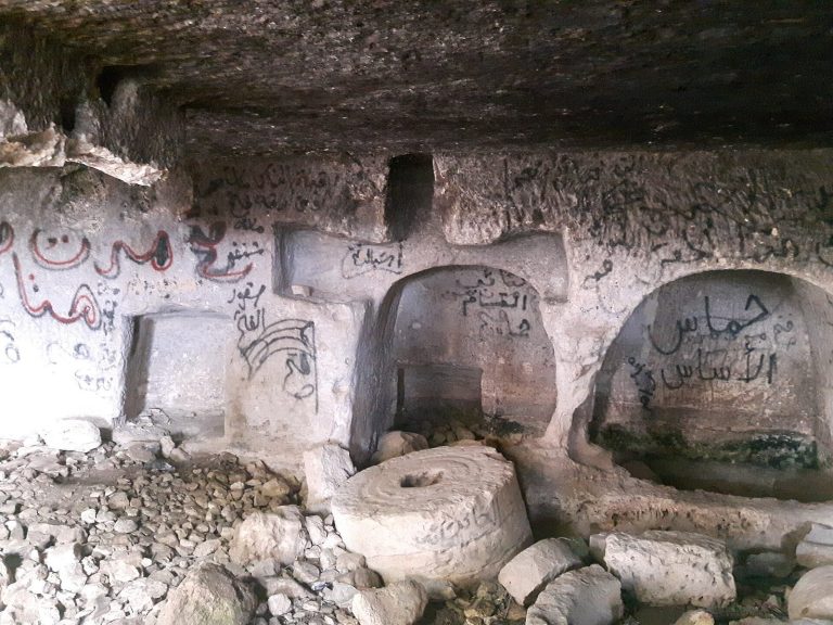
Forty-three underground installations from the Hellenistic and early Roman periods include storage pits, cisterns, ritual baths, cellars, presses, the hiding complex, and a tomb. The hiding complex connected three chambers: a converted olive-press cave, a large cistern, and a smaller inner chamber reached by tunnel. Eight niches for oil lamps were cut into the inner chamber’s walls. A stone wall blocked the cave entrance, leaving a narrow crawl space; a concealed passage into the cistern allowed water to be drawn unseen. Another tunnel led to a cavern with a stone plate that could be shut from inside.
Coins from both Jewish revolts were recovered in the complex. Disarticulated human remains radiocarbon-dated to the first century CE have been interpreted as those of refugees from the First Jewish Revolt. Fragmentary remains in a neighboring cavern may relate to either revolt.
Ritual baths, presses, and storage
Three late Second Temple-period ritual baths were excavated. The fill of one contained a coin dated to the second year of the First Jewish Revolt; another, numbered 3, yielded 21 coins, two flint blades, and fragments of stone vessels. A winepress operated in a western chamber of the Bronze Age gate that had been adapted for the purpose during the Hellenistic and early Roman periods. At the village’s eastern edge, an underground olive-press cave was flanked by two ritual baths, possibly reflecting the production of oil in a state of ritual purity for use in the Temple in Jerusalem.
Tomb and household finds
A rock-cut tomb about 100 m southwest of the settlement had one chamber with seven burial niches. It contained remains of at least 18 people, aged from four to over 50 according to dental analysis. Tool marks indicate the work of at least three masons; two niches remained unfinished where a vein of hard stone interrupted the bedrock.
Four ceramic jar stands came from early Roman contexts, and three bear a single Hebrew character. Two are marked with het; a third carries lamed, perhaps an abbreviation for log, an ancient Jewish measure of liquid volume. The marks may have identified a stored product or its quantity. Another incised pottery fragment, from the late Hellenistic period, bears a clear tsade in a script style of the first century BCE.
Military evidence
Military finds include 55 hobnails, with the best-preserved examples most likely dating to 40–80 CE. The largest concentration came from the central first-century dwelling. About 300 rounded stone balls were recovered, including two large enough for a ballista, a mechanical weapon that launched stones or bolts. The heavier weighed 1.96 kg and corresponds to a six-libra caliber; another weighed about 1 kg and corresponds to a three-libra caliber. Both calibers are associated with Legio V Macedonica and Legio XV Apollinaris.
Five arrowheads were found, four of them Roman types with narrow, armor-piercing points. One lay beside human remains. Other finds include a curved blade fragment that may be a sica, a curved weapon associated with the Sicarii; two small metal discs with flower designs, possibly ornaments for a harness; and a 6.7 cm iron buckle resembling Roman saddle-girth hardware.
Byzantine and early Islamic complex
Basilica and entrance courtyard
The Byzantine church was a basilica, a large religious hall with a central space and flanking aisles, measuring 39.35 by 15.50 m. Two rows of five pillars divided the central nave from two side aisles. In front of the central apse, a projecting, often semicircular end of the church, a vaulted underground chamber supported steps rising about 2 m to the raised sanctuary area. Two side rooms probably held sacred vessels, vestments, and liturgical books. The roof used flat and curved terracotta tiles, while the floors combined flagstone paving and mosaics.
An entrance complex and courtyard lay west of the basilica. Six marble fragments may have belonged to the altar, a screen separating the sanctuary, and a screen support. Green and brown glass fragments may have come from windows set high in the church.
Monastery and agricultural buildings
The monastery’s western rooms included plain chambers and a plastered installation that may have been a baptistery or a vat for liquids. A walled agricultural terrace lay immediately north of the monastery. A nearby granary and presses for olives and grapes indicate facilities for processing grain, oil, and wine. Cattle, sheep, goats, and chickens were the principal domesticated animals identified from the complex.
Christian objects and later reuse
A marble altar-post capital found in the courtyard bears an inscription arranged around the Chi-Rho, a Christian monogram, with Alpha and Omega, the first and last letters of the Greek alphabet and symbols of Christ as beginning and end. Other finds from the hill include a pottery fragment with an incised Byzantine cross and two fragments bearing Greek letters. A possible fragment of a Jewish burial container was reused in the church.
During the early Islamic period, a new wall blocked the complex’s original western entrance. A complete oil lamp with a channel-shaped nozzle came from the western area; elsewhere at the site, finds include two Islamic gold coins, glazed pottery fragments, and a small brass band with a simple coiled design, probably from this period.