Ingolstadt Fortress: A Bavarian Fortress on the Danube


Site at a Glance
- Rating
- 4.6
- Popularity
- Low
- Country
- Germany
- Primary era
- Modern
- External website
- Open
- Eras represented
- Medieval, Early Modern, Modern
- Civilizations
- Duchy of Bavaria, Electorate of Bavaria, German, Holy Roman Empire
- Site type
- Military
- Remains
- Wall
On this page13 sections
History
Ingolstadt Fortress in Germany was a Bavarian military stronghold built around Ingolstadt on both banks of the Danube. Its development passed through five principal phases: medieval fortifications, a Renaissance fortress, expansion after the Thirty Years’ War, a nineteenth-century Neoclassical fortress, and a later belt of outer forts. The site’s changing form reflects the military importance of Ingolstadt, particularly its roads, Danube bridge, and position near Bavaria’s northwestern frontier.
Medieval and Renaissance foundations
The medieval town fortifications formed the foundation for later works. Duke Wilhelm IV decided to expand Ingolstadt into a state fortress, and the Renaissance rebuilding took place from 1538 to about 1545 under Reinhard, Count of Solms, a military engineer and fortress designer. Ingolstadt stood at the intersection of important roads and controlled a crossing of the Danube, while its position near the duchy’s northwestern frontier increased its defensive value.
The Renaissance plan placed a masonry-faced earth rampart and ditch in front of the medieval town wall. Bastions, projecting fortifications designed to provide flanking fire along adjoining walls and ditches, stood at the corners. They allowed artillery to cover the ditch and helped protect neighboring sections of the rampart.
Expansion after the Thirty Years’ War
The fortress was strengthened and enlarged after the Thirty Years’ War, the conflict that devastated much of Central Europe between 1618 and 1648. Christoph Heidemann directed the principal works from 1654 to 1662. Expenditure reached 20,000 gulden between 1651 and 1653 and 260,000 gulden from 1654 to 1662, despite Bavaria’s postwar devastation.
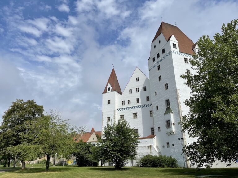
The inner wall of the main ditch was raised, and new bastions were built in front of the earlier ones, separated from them by a wet ditch. Heidemann also closed the Harder Gate because fortress gates were regarded as vulnerable points. The expanded defenses included the Esel, Feldkirchner, Eiskeller, Sebastians, Ziegel, Lange Kurtinen, Harder, Kugel, Kreuztor, Frauen, Rauchloch, and Münzberg bastions, together with the Danube front and a bridgehead. The Feldkirchner Ravelin, a detached outwork placed before a wall or gate, connected the route toward Feldkirchen by two bridges. The Danube front extended the earthwork built during the war as far as the New Castle.
Sieges and French demolition
Ingolstadt was besieged in 1704 during the War of the Spanish Succession, a European conflict over the Spanish monarchy, by troops commanded by Margrave Ludwig of Baden. The siege ended when an opposing victory at Höchstädt required the besieging forces for the occupation of Ulm. During the War of the Austrian Succession, another European struggle involving the Habsburg monarchy, imperial troops conducted a mock siege in 1743. The mainly French garrison under General Grandville capitulated without military necessity, surrendering the fortress, 115 guns, and more than 10,000 firearms.
Under Elector Karl Theodor, funds for maintenance were unavailable and the fortress deteriorated. Imperial troops took over its garrison from 1796. After the Armistice of Hohenlinden, which ended fighting between France and Austria in 1800, the fortress was handed over without a fight to Napoleon’s forces. French troops demolished it between November 1800 and March 1801.
The Neoclassical royal fortress
King Ludwig I authorized the rebuilding of the fortifications destroyed in 1801 in 1826, using savings made by the Military Savings Commission. He selected Ingolstadt as the principal royal Bavarian fortress instead of the locations favored by the fortress-construction commission and Commander Wrede. Ingolstadt lay almost at the geographical center of the new kingdom and was considered capable of facing attacks from both France and Austria.
Large-scale construction began in 1828 with the foundation stone of Reduit Tilly at the bridgehead. A reduit was a fortified inner work intended to serve as a final defensive position. Michael von Streiter initially directed the project in cooperation with Leo von Klenze, and Peter von Becker later became responsible for it. At times as many as 7,000 workers were employed. Ingolstadt had about 4,400 inhabitants in 1818, after the fortress had been demolished and the university had left in 1800, but its population exceeded 13,000 by 1846, partly because of the economic growth created by the building works. The fortress was declared capable of defense in 1849, and approximately 23 million gulden had been spent by 1855, making it the costliest building project of Ludwig I’s reign.
Streiter designed the bridgehead with a circular plan, while Becker used a polygonal system on the northern bank of the Danube. The southeastern flank followed irregular fronts along remains of the pre-1800 fortifications. The sections north of the Schutter were built as regular fronts.
The outer fort belts
Streiter’s original plans called for four detached forts on the left bank of the Danube, about 1,100 metres from the main enceinte, or principal fortified enclosure. He considered them necessary because artillery range was developing rapidly and the city had to be protected from bombardment. After Streiter’s dismissal over cost overruns, Becker became fortress-construction director. Three detached forts, Haslang to the west, Max Emanuel to the north, and Wrede to the east, were planned together with the Habermann and Minucci cross-blockhouses.
Land for the detached forts had been acquired by 1835, and construction of the two cross-blockhouses began in 1837. Lack of money and the rapid development of artillery delayed the detached forts until 1859. The planned northern fort, Max Emanuel, was moved farther from the main enceinte to the Etting Heights as gun range increased. The mobilization order of 10 May 1866 gave the works new urgency. From 1866 to 1871, three missing outer forts and seven additional temporary works on the right bank were built in earth and timber. The three left-bank detached forts were constructed as permanent works between 1868 and 1872.
Further increases in artillery range led to a second, more distant fort belt. Work began in 1875, and reinforcement measures prompted by the high-explosive-shell crisis were completed by 1895. Seven intermediate works and nine outer forts were built between five and eight kilometres from the city center.
Abandonment and survival
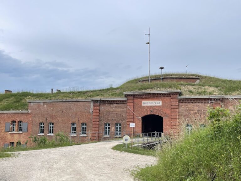
The fortress was finally abandoned in 1937. The permanent forts passed to the Army Ordnance Office and were generally used by the Wehrmacht until 1945 as ammunition depots or facilities for ammunition preparation. After the Second World War, American occupation forces demolished the other outer forts. Fort VI Prinz Karl at Katharinenberg survived and now houses Ingolstadt’s explosives-disposal unit.
Medieval town walls and substantial remains from later fortress phases survived in Ingolstadt. A postwar proposal to remove the remaining fortifications from the cityscape was abandoned. The Neoclassical works were subsequently restored and given new uses, preserving the visible record of the fortress’s successive transformations.
Remains
The surviving fortress combines the nearly completely preserved medieval town enceinte with remains of Renaissance, Neoclassical, and outer-belt defenses. Together, the walls, ditches, bastions, cavaliers, bridgehead structures, and detached fort provide a physical record of how Ingolstadt’s defenses were repeatedly enlarged as artillery developed.
Medieval and Renaissance defenses
The Renaissance works were arranged outside the medieval wall. Their masonry-faced earth rampart and ditch formed the main defensive line, while corner bastions projected outward to deliver flanking fire across the adjoining walls and ditch. The masonry remains of the first three Renaissance bastions survive. The Kugel Bastion and Harder Bastion remain in use, while the other Renaissance works are known through Jakob Sandtner’s detailed city model of 1572 to 1573.
Seventeenth-century bastions and Danube front
Heidemann’s expansion raised the inner wall of the main ditch and set additional bastions before the earlier defenses across a wet ditch. The Esel Bastion stood before the earlier Esel Cavalier. The Feldkirchner Ravelin occupied the ground before the Ross Mill, and the Eiskeller Bastion stood before the Feldkirchner Gate. The Sebastians Bastion took its name from the nearby Church of St. Sebastian.
The Ziegel Bastion had a masonry escarp, the inner face of a ditch, and a gorge, the inward-facing rear side of an outwork. The Lange Kurtinen Bastion stood before the main rampart between the Harder and Ziegel bastions. The Harder Bastion stood before the earlier Harder Cavalier, while its gate was bricked up and its gate tower demolished. The Kugel Bastion stood before the Kugel Cavalier, and the Kreuztor Bastion before the roundel at the Cross Gate, later called the Cross Gate Cavalier.
The Frauen Bastion stood before the roundel near the Women’s House. The Rauchloch and Münzberg bastions completed the sequence. The Münzberg Bastion stood before the roundel at the Red Tower, later called the Münzberg Cavalier. Its associated defensive structure was intended to prevent excessive drainage from the ditches when the Danube was low. The Danube front extended the wartime earthwork to the New Castle, while the bridgehead took the form of a hornwork, an outer fortification with projecting arms and connecting defenses, equipped with a hornwork lunette, a detached outwork with a curved or angular front.
Evidence from the Baroque fortress
The Baroque buildings themselves do not survive, but an archaeological discovery preserves evidence of their military use. In 1983, several hundred ceramic grenades were found during construction of an underground garage at the foot of the former Feldkirchner Gate Bastion. They had probably been discarded in a wall ditch that was later filled before 1723. Many still contained their original black-powder charges and fuzes.
Neoclassical bridgehead and city fronts
The Neoclassical fortress was organized as alternating fronts and raised artillery positions called cavaliers. Its principal works included Cavalier Dallwigk with Raglovic Front; Cavalier Heydeck with the New Feldkirchner Gate and Rechberg Front; Cavalier Elbracht with Zoller Front; Cavalier Spreti with the New Harder Gate and Vieregg Front; Cavalier Hepp with the New Cross Gate and Pappenheim Front; Cavalier Zweibrücken; Schutterhof; Butler Front with Baur Tower; Preysing Front with Triva Tower; Deroy Gorge; the Reduit Tilly bridgehead fortification; and Gumppenberg Front with a flanking tower.
All the Neoclassical cavaliers survive except Cavalier Spreti, demolished in 1963. Among the fronts, Rechberg Front and the foundations of Raglovic Front survive. The bridgehead structures stand within what is now Klenze Park. Ditches and walls from the irregular fronts and from Preysing Front, now called Fronte 79, also remain.
Detached forts and outer belt
The first outer defenses were placed well beyond the main enclosure. Habermann and Minucci were built as cross-blockhouses before the detached forts. Haslang, Max Emanuel, and Wrede were later constructed as permanent works on the left bank, while the additional right-bank defenses built between 1866 and 1871 initially used earth and timber.
The later outer belt contained seven intermediate works and nine outer forts between five and eight kilometres from the city center. Fort VI Prinz Karl at Katharinenberg is the surviving fort from this belt. It remains in use by Ingolstadt’s explosives-disposal unit.
Nearby sites