Holterhöfchen: A Tenth-Century Ringwall Fortification in Germany

Site at a Glance
- Rating
- 4
- Popularity
- Very Low
- Country
- Germany
- Primary era
- Medieval
- Eras represented
- Medieval
- Civilizations
- Holy Roman Empire
- Site type
- Military
- Remains
- Fort
On this page8 sections
History
Holterhöfchen is a ringwall fortification in Hilden, Germany, formed around a fortified farmstead established in the tenth century during the early medieval period. A ringwall is an enclosed bank or rampart, often supported by external ditches. The site replaced an earlier farmstead that was destroyed by fire toward the end of the ninth century and was then protected by a double ditch and double rampart.
Origins and Fortification
Excavations and the study of ceramic sherds found in 1887 by Constantin Koenen, a German archaeologist, led to the fortification being dated to the ninth or tenth century. For more than 130 years, researchers worked to interpret its unusual form, which differs from regional fortification patterns. The current interpretation places the construction of the new farmstead in the tenth century, after the destruction of its predecessor.
The builder and owner are thought to have been a member of the lesser nobility, meaning a noble person below the principal ruling or high aristocratic families. The circular arrangement is also interpreted as evidence that the builder had migrated into the Rhine Valley from the north or east and brought knowledge of a round-settlement building tradition. In this type of layout, buildings are arranged around a central open area.
Landscape and Watercourse
Holterhöfchen stood between the Lower Rhine Terrace and the lower Middle Terrace, stepped landforms created by earlier river activity. The fortification occupied the sandy Lower Rhine Terrace, while associated working areas probably extended eastward onto the loess soil of the lower Middle Terrace. Trade routes, including the Mauspfad and Schutzstraße, lay west of the site on the lower terrace near the Rhine plain. To the east, dense woodland still covered the ground in the tenth century, rising toward Wald, now part of Solingen.
The reinforced side faced west toward the lower terrace and the present fire station, suggesting that this was considered the likely direction of danger. The Mühlenbach, a side channel of the Itter, also shaped the setting. Until 1819, it approached from the northeast, passed around the northern side of Holterhöfchen, and continued toward the Oberste Mühle, now Gottschalks Mühle. Construction work in 1819 dried out the southern section surrounding the site and straightened the stream along Walder Straße.
Later Alterations
Part of the rampart was removed between 1870 and 1878, when its earth was used to raise the ground around a house. The present public green space was created in 1885 and 1886, then modernized in 1965 and 1966. These changes shaped the modern appearance of the site while leaving the surviving masonry of the fortified farmstead as its principal physical evidence.
Remains
Ringwall and Ramparts
The fortification occupied flat ground at the transition between two river terraces and enclosed an interior measuring about 60 by 80 metres. Its defensive layout consisted of two ditches and two ramparts. An outer third rampart was once proposed, but that interpretation was later rejected. The feature identified in that way is understood as the original ground surface into which the outer ditch was cut.
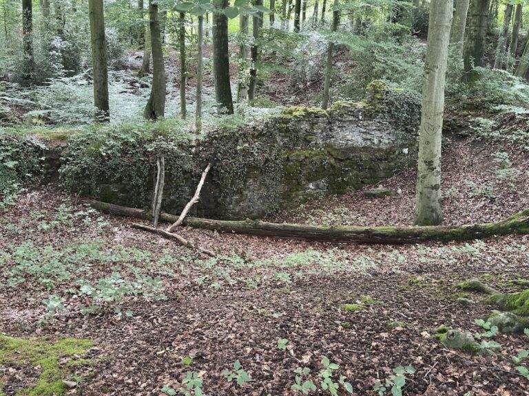
A large section of the rampart is missing in the northwest as a result of the earth removal carried out between 1870 and 1878. Elsewhere, the outer rampart incorporated a stone wall approximately 1.2 metres thick. The wall was built directly on the natural ground and then banked on both sides with soil dug from the ditches. Its low projection above ground level would have offered attackers little cover from defenders on the inner rampart, while its masonry could resist battering rams.
The inner rampart contained a stone wall about one metre thick, with an earthen bank piled behind it. This wall probably served chiefly as a breastwork, a low defensive wall or embankment behind which defenders could take cover. Its construction provided a firing and protective position for defenders around the enclosure, although it was not designed to withstand battering rams in the same way as the outer wall.
Entrance and Visible Masonry
A gate complex probably stood on the southeastern side, facing Pungshaus. A rectangular building was later erected beside the gate on the outer rampart. Measuring approximately 6.5 by 7 metres, it is represented by masonry that forms the visible remains of the ringwall fortification. The structure therefore preserves evidence of a later addition beside the entrance, as well as the defensive arrangement of the rampart itself.
Watercourse and Internal Area
The former course of the Mühlenbach approached Holterhöfchen from the northeast and curved around its northern side before continuing toward the Oberste Mühle. The southern part of this enclosing watercourse was dried out in 1819, when the stream was straightened along Walder Straße. The altered channel records the relationship between the fortification and the surrounding water system before nineteenth-century construction changed it.
The farmstead’s internal buildings were probably made of wood, while the later path through the site appears to have been added after the original arrangement. The surviving rectangular masonry building and the earthworks together provide the clearest physical evidence for the site’s entrance area, defensive construction, and changing use over time.