Golconda Fort: A Historic Citadel in Hyderabad, India
Site at a Glance
- Popularity
- Very High
- Country
- India
- Primary era
- Early Modern
- Eras represented
- Medieval, Early Modern
- Civilizations
- Unclassified
- Site type
- Military
- Remains
- Fortified Town
On this page25 sections
History
Golconda Fort is a fortified citadel on a granite hill in Hyderabad, India. Its beginnings are uncertain, but local tradition dates the first mud fort to 1143, when a Kakatiya ruler is said to have ordered its construction after a herder found a sacred image on the hill. The name is traditionally linked to Gollakoṇḍa, meaning “Shepherd’s Hill.”
Kakatiya and Musunuri rule
The Kakatiyas, a medieval dynasty that ruled in the Deccan from 1083 to 1323, used Golconda as an important fort. After their rule, the Musunuri Nayakas, a regional power, also held it. In 1323, Ulugh Khan, a prince of the Tughluq dynasty of the Delhi Sultanate who later ruled as Muhammad bin Tughluq, captured the fort. A Musunuri revolt later recovered Golconda along with Warangal.
In 1343, Musunuri leader Kapaya Nayaka regained Golconda after defeating an army associated with Muhammad bin Tughluq. Further fighting with Bahmani Sultan Muhammad Shah I ended in a settlement under which Kapaya surrendered the fort. By 1373, the Musunuris had relinquished it permanently. The settlement included 300 elephants, 200 horses, and 3.3 million rupees.
Qutb Shahi capital and trading center
Golconda passed to the Bahmani Sultanate and later became the seat of its governor, Sultan Quli. As Bahmani authority weakened, he established the independent Qutb Shahi sultanate in 1518, making Golconda its capital. The first three Qutb Shahi rulers expanded the fort over about 62 years. The dynasty ruled territories that included Telangana and parts of present-day Karnataka and Maharashtra. Golconda remained its capital until the court moved to Hyderabad in 1590.
The Qutb Shahis followed Shi’a Islam, one of the major branches of Islam, and Golconda became a center of that faith. Two clerics from Bahrain moved there in the 17th century. The city also prospered through diamond trading. Nearby mines, including those at Kollur and Paritala, supplied stones that were cut, polished, and traded in Golconda; mines within the fort itself produced only small quantities. This commerce brought wealth to the Qutb Shahi rulers and later contributed to the prosperity of the Nizams.
Cotton weaving was another important industry in the early 17th century. Workshops produced muslin, a fine, lightweight cotton cloth, and calico, a plain-woven cotton cloth. Fabrics included plain white, brown, bleached, or dyed cloth, as well as patterned textiles colored with indigo, chay root, and vegetable yellow. Plain cloth went to Persia and European countries, while patterned cloth was sent mainly to Java, Sumatra, and other eastern markets.
Mughal conquest and later history
Mughal emperor Aurangzeb captured Golconda in 1687 after a siege of about eight months. The conquest ended Qutb Shahi rule, and the last ruler, Abul Hasan Qutb Shah, was taken captive. The fort was damaged and subsequently declined into neglect and ruin.
Asaf Jah established independent rule over Hyderabad in 1724. His successors, known as the Nizams, ruled the state until it became part of India in 1948. Golconda is included in the Archaeological Survey of India’s official list of monuments. It was submitted for UNESCO World Heritage consideration in 2010 and appeared on India’s tentative list by 2014 as part of the “Monuments and Forts of the Deccan Sultanate” nomination. A Golconda Artillery Centre was established in and around the fort in 1962 as a recruit-training center for the Indian Army’s Regiment of Artillery. Its three training regiments accommodate 2,900 recruits at a time.
Remains
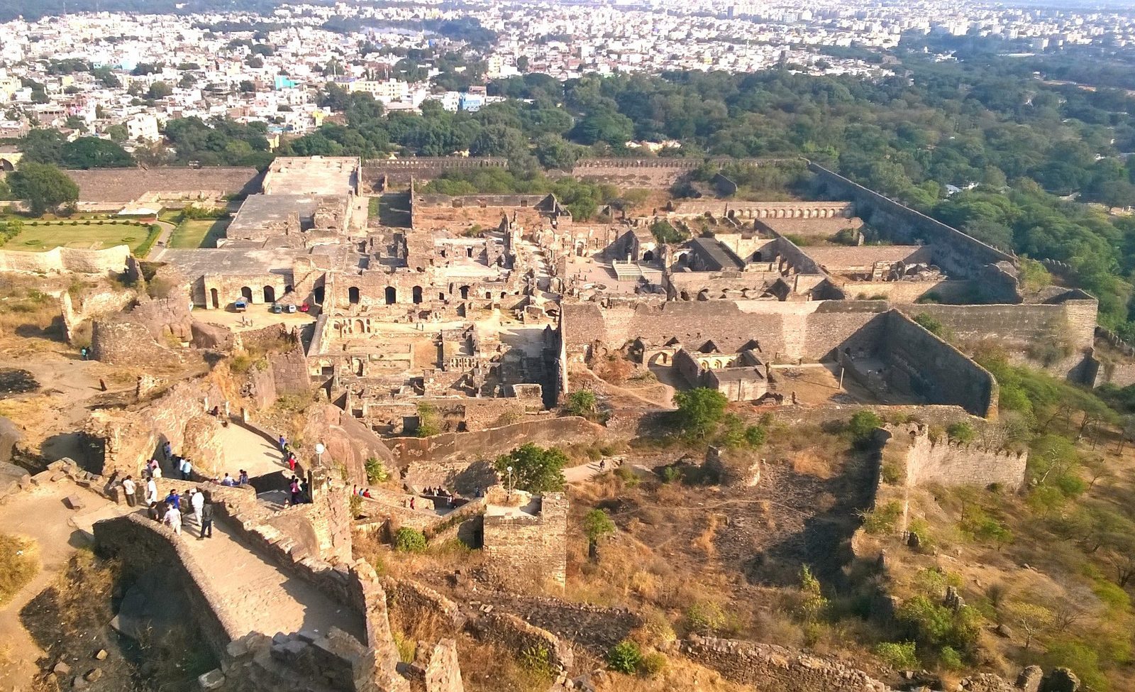
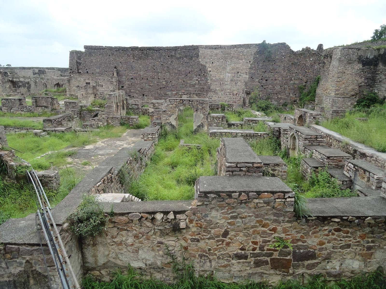
The site occupies a granite hill about 120 metres high and is arranged as a layered fortified settlement, with enclosures, defensive walls, entrances, and buildings within the protected area. Granite is prominent in the fortifications, while stone channels and pipes formed part of its water system.
Fortifications and entrances
Walls and defensive works
Four distinct forts are arranged one within another, alongside three lines of defensive walls. A granite circuit wall measures about 5 kilometres around, the wall enclosing the city is about 7 kilometres long, and an outer wall extends about 10 kilometres. The moat is also roughly 7 kilometres long. The outer wall rises 15 to 18 metres and carries 87 semicircular bastions, some still fitted with cannons. Four drawbridges served the complex.
Gates and warning system
The entrances include the Fateh Darwaza, Moti Darwaza, New Fort Gate, Jamali Darwaza, Banjara Darwaza, Patancheru Darwaza, the double Makkah Darwaza, Bodli Darwaza, and Bahmani Darwaza. The Fateh Darwaza, or Victory Gate, is the lowest and outermost entrance, near the southeastern corner. Iron spikes on its gate were intended to stop elephants from breaking through. A clap at a particular spot beneath the dome carries clearly to the Bala Hisar pavilion, about a kilometre away. The acoustic arrangement served as a warning signal.
Bala Hisar Gate
Bala Hisar, meaning the upper citadel, has its main entrance on the eastern side. The gate’s pointed arch bears scrollwork, mythical yali figures, roundels, peacocks, and an ornamental niche; a granite block below carries carved yalis and a disc. Its decorations bring Hindu and Islamic elements together. A small opening on the gate’s outer side allowed defenders to pour hot oil or molten metal onto attackers.
Bastions and cannons
Named bastions include Petla in the northwest, Musa in the south, and Majnu. A bastion is a projecting defensive structure. Petla carries a cannon about 16 feet long, associated with Aurangzeb’s victory, which could take cannonballs weighing about 165 pounds. Musa Bastion was built in 1666 under the military commander Musa Khan by the mason Dharmachari, and it too carries a cannon.
Upper citadel and court buildings
Bala Hisar audience pavilion
About 380 uneven stone steps lead from Bala Hisar Gate up the hill to the three-storey Bala Hisar audience pavilion. Its 12 arches rest on sturdy columns, and curved chambers are built into the structure. A raised room opens to the rear through three arches, while a stone throne stands on a raised terrace. Double walls channel air through the rooms, providing natural cooling. The elevated pavilion offered a view described as reaching about 30 miles, including landmarks around Hyderabad and the surrounding area.
Audience halls and royal quarters
The Bala Hisar enclosure contained audience halls, wells, a reservoir, a large garden, baths, religious buildings, a prison, an ammunition store, and an armory. Darbar-e-Aam served as a public audience hall, while Darbar-e-Khan was an important council hall. The royal palace stood to the left of the route to Darbar-e-Aam. At Dād Mahal, a balcony faced an open area where people brought their concerns to the ruler.
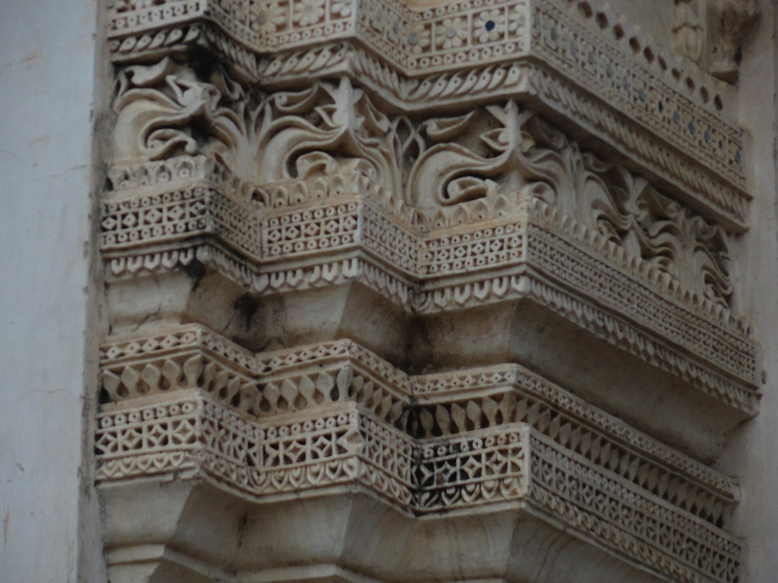
Royal residences and women’s quarters stood on raised mounds and were reached by narrow, steep stairs. Their high ceilings and decorated walls, eaves, and arch panels used Persian-influenced designs. Local tradition places a secret passage between the court hall and a palace at the foot of the hill, and another tunnel is said to have linked the fort with Charminar.
Water systems and service structures
Waterworks and Badi Baoli
The fort’s water system used clay pipes visible among the rocks and stone aqueducts that supplied gardens and fountains. A canal carried water from a tank about five miles away to gardens and fields. Beside the Bala Hisar steps, Badi Baoli, a large stepwell, includes a stone at one corner that helped water descend during summer. A nearby building with two verandas provided a place for rulers to sit and view the landscape.
Katora House and royal bathing rooms
Katora House, north of Bala Hisar, is a water-holding structure about 200 yards long and wide and five yards deep. A pond supplied it, and sound made near its western gate echoed through the structure. Rulers and other prominent people used it for recreation. Near Bala Hisar Gate, royal bathing rooms received hot and cold water through underground pipes from a tank. The water was used on important occasions and for the final washing of deceased royal family members before their coffins left through the north gate.
Oil storehouse and secure vault
A storehouse cut from stone measures 30 feet long, 15 feet wide, and 10 feet deep. It held and supplied as much as 12,000 gallons of oil. A separate secure vault within the fort once held the Koh-i-Noor and Hope diamonds.
Religious buildings and gardens
Ibrahim Mosque and nearby shrine
Ibrahim Quli Qutb Shah built the Ibrahim Mosque in 1518. Minarets stand at its corners, and its courtyard extends toward the fort’s bastions. A small Ram temple cut into the nearby granite is associated with Bhakta Ramadas, a Telugu devotional figure who was imprisoned in the fort. Carvings of Rama, Lakshmana, and Hanuman appear on rocks there. The fort also contains Taramati Mosque and Jama Mosque.
Hindu temples
A stone Hindu temple from the Kakatiya period is known as Madanna temple and contains a painted image of Kali. A shrine to Durga or Mahakali was built during Abul Hasan’s rule, with his ministers Akkanna and Madanna associated with its construction. The Jagdamba temple stands beside the Ibrahim Mosque and royal palace. Described as about 900 to 1,000 years old, it is visited during the annual Bonalu festival, when offerings are made to the goddess.
Nagina Bagh
Arches in Nagina Bagh have holes in their stones, evidence of fittings for swings used by princes and princesses. A guard building stands beside a narrow path from the garden. Nearby, an office was built for the ministers Akkanna and Madanna during Abul Hasan’s reign.
Structures beyond the fort
Taramati and Premamati pavilions
On rocky ground outside the fort stand the Taramati and Premamati pavilions. The sisters Taramati and Premamati lived there and performed on an upper-floor circular platform called Kala Mandir. Their performance space could be seen from the royal court atop the fort.
Qutb Shahi tombs
The Qutb Shahi tombs lie about a kilometre north of the fort’s outer wall. Their Indo-Islamic architecture includes carved stonework, and gardens surround the tombs.
Khazana Building
The nearby Khazana Building was constructed in 1580 as a Qutb Shahi treasury. It was restored in 2013 and converted into a museum.