Fortress of Luxembourg: A Nine-Century Fortified System


Site at a Glance
- Rating
- 4.7
- Popularity
- Low
- Country
- Luxembourg
- Primary era
- Early Modern
- External website
- Open
- Eras represented
- Medieval, Early Modern, Modern
- Civilizations
- Duchy of Burgundy, Duchy of Luxembourg, French, Habsburg, Holy Roman Empire, Kingdom of Prussia, Spanish
- Site type
- Military
- Remains
- Fort
On this page22 sections
History
The Fortress of Luxembourg was the fortified system of Luxembourg City, Luxembourg, developed progressively from the tenth century until 1867. Its origins lay in a Roman defensive position, while its later expansion involved medieval rulers, Burgundian, Habsburg, French, Austrian, and Prussian authorities. The fortress occupied a strategic height above the Alzette and Pétrusse rivers, overlooking routes toward the Rhine, the Low Countries, and the frontier between France and Germany.
Roman and Medieval Origins
In Roman times, a circular wooden palisade protected a road crossing on the plateau above the Alzette and Pétrusse. A small Roman fortification on the Bock promontory was known as Lucilinburhuc, a name that later developed into Lützelburg and Luxembourg. After Roman rule ended, the defensive site fell into disrepair.
In 963, Count Siegfried of the House of Ardennes acquired the land from St. Maximin’s Abbey in Trier in exchange for his territories at Feulen near Ettelbrück. He built a small castle on the Bock and connected it to the plateau by a drawbridge. A settlement grew around the stronghold. Knights and soldiers occupied the rocky outcrop, while artisans and merchants established themselves below.
By the twelfth century, the settlement had become a city protected by a wall along the line of the present Rue du Fossé. A second wall incorporated the Rham Plateau in the fourteenth century, and a third later extended the fortified area toward the line of the present Boulevard Royal. Reinforcement begun in 1320 under John the Blind continued through the late fourteenth century. Luxembourg was raised from a county to a duchy in 1354.
Burgundian and Early Modern Expansion
In 1443, Philip the Good and Burgundian troops captured Luxembourg in a surprise night attack. This began a period of foreign rule, although the fortress later acquired a reputation for being exceptionally difficult to conquer by force. By marriage, the fortress and the Burgundian possessions passed to the Austrian Habsburgs in 1477. French troops under Francis I captured it in 1542, but forces of the Holy Roman Empire, the multi-state political entity that dominated central Europe until 1806, soon retook it.
During the following centuries, Burgundian, French, Spanish Habsburg, Austrian Habsburg, and Prussian authorities repeatedly altered and enlarged the defences. Around 1545, engineers from Italy and the Netherlands working under Emperor Charles V built the first modern bastions. A bastion was a projecting part of a fortified wall designed to provide fire along adjoining walls, while a curtain wall connected the projecting works. These structures followed the lines of the present Boulevard Franklin D. Roosevelt and Boulevard Royal. The surrounding ditch was widened from 13 to 31 metres, and ravelins, triangular exterior works placed before a wall or gate, were added.
During the Spanish occupation, the threat from Louis XIV’s France led to further construction from 1672. Jean-Charles de Landas, Count of Louvigny, built the Peter, Louvigny, Marie, and Berlaimont redoubts in front of the glacis. A redoubt was a detached or enclosed defensive work, while a glacis was a gently sloping bank of earth intended to expose attackers to defensive fire. Louvigny also constructed the city’s first barracks, creating a second defensive line. His works formed part of a wider effort to protect the fortress from French expansion.
After Louis XIV’s siege of 1683 to 1684, French troops regained Luxembourg. From 1684 to 1688, the French military engineer and marshal Sébastien Le Prestre de Vauban directed a major reconstruction and expansion employing more than 3,000 men. His system of bastions, outworks, and layered defensive lines strongly influenced European fortress design. At Luxembourg, his works strengthened the surrounding heights, incorporated Pfaffenthal into the defences, and added large barracks on the Rham and Saint-Esprit plateaux.
Vauban’s expansion included the crownwork at Niedergrünewald, the hornwork at Obergrünewald, the Corniche de Verlorenkost, Fort Bourbon, and several redoubts. A crownwork and a hornwork were advanced fortifications with projecting arms and defended fronts, intended to protect important approaches or high ground. After the Peace of Ryswick, the fortress returned to Spanish control in 1698 and to French administration in 1701. The Treaty of Utrecht transferred it to the Dutch for two years in 1713, after which Austrian troops took possession in 1715.
Austrian Fortification and the French Revolutionary Wars
Under Charles VI and Maria Theresa, Luxembourg became one of the principal strategic supports of the Austrian Netherlands against French expansion. Austrian engineers reinforced Vauban’s works, added lunettes and the exterior forts of Olizy, Thüngen, Rubamprez, Rumigny, Neipperg, Wallis, Rheinsheim, and Charles, and closed the valleys with locks. Extensive casemates were excavated beneath the Bock. A casemate was a protected vaulted space used for military purposes. The fortress acquired three defensive lines on all sides, with the engineer Simon De Bauffe responsible for planning and carrying out its largest expansion.
These changes also transformed the landscape around the fortress. The expansion of the glacis removed agricultural soil down to bedrock for about 600 metres from the defences, creating the rocky area known as the “bare fields.” The clear ground made it more difficult for attackers to dig approach trenches. An Austrian security perimeter established in 1749 also prohibited permanent construction in order to preserve fields of fire and unobstructed views.
French Revolutionary troops captured Luxembourg in 1795 after an eleven-month blockade and siege. The duchy was incorporated into the French Republic as the Département des Forêts and later into the French Empire. The surrender enabled France to control and annex the southern Netherlands. General Louis Antoine Vimeux became governor of the fortress on 10 October 1802.
As French rule collapsed, the fortress was blockaded from 15 January 1814. Hessian troops of the Fourth Federal Corps took over the blockade on 11 February. The French surrender was received by the Austrian general Franz Josef Desfours on 23 April, and the French garrison departed on 3 May. Prussian troops had already occupied the fortress from 8 July 1814.
Federal Fortress and Prussian Garrison
After Napoleon’s final defeat, the Congress of Vienna in 1815 made Luxembourg a grand duchy in personal union with the Netherlands and a member of the German Confederation, an association of German states established in 1815 and dissolved in 1866. The fortress consequently became a federal fortress. The Dutch king remained sovereign, while Prussia obtained the right to appoint the governor. The planned garrison was one-quarter Dutch and three-quarters Prussian, with 6,000 men in peacetime, although the Netherlands never supplied its quarter and the garrison consisted exclusively of Prussian troops.
The German Confederation formally took over the fortress on 13 March 1826, although Prussia had occupied it since 1814. Prussian troops modernised the existing works and added Fort Wedell and Fort Dumoulin. A treaty of 17 November 1856 gave Prussia the exclusive right to station troops in Luxembourg. The fortress remained a federal installation while also serving Prussian geopolitical interests as its westernmost bulwark.
During the Belgian Revolution, most of Luxembourg supported the Belgian rebels, and much of the territory was administered by Belgium from 1830 to 1839. The city and fortress, held by Dutch and Prussian troops, remained loyal to William I. The Treaty of London of 1839 assigned western Luxembourg to Belgium while leaving the city, fortress, and remaining territory under William I.
After Prussia’s victory in the Austro-Prussian War of 1866, the German Confederation dissolved and the North German Confederation was formed without Luxembourg. French efforts to acquire Luxembourg from William III, encouraged by earlier understandings involving Otto von Bismarck and Napoleon III, produced the Luxembourg Crisis. The Second Treaty of London in 1867 guaranteed Luxembourg’s permanent neutrality, ended its military role, and required the dismantling of the fortifications. The Prussian garrison remained until 9 September 1867.
Demolition and Urban Transformation
Demolition lasted from 1867 to 1883 and cost 1.5 million francs. An international commission inspected the work in 1883. Defensive structures were destroyed or broken through for roads, while military remains converted into cellars or warehouses were removed and other areas were covered with earth. Former barracks housed demolition workers, and the work provided employment during economic downturns.
The dismantling was regarded at the time as liberation from foreign military domination. It removed restrictions on urban construction and allowed Luxembourg City to expand for the first time since the fourteenth century. Boulevard Royal, the Municipal Park, the Adolphe Bridge, the Bourbon Plateau, Avenue de la Liberté, Limpertsberg, and Belair developed in the space opened by the former military system.
Luxembourg became fully independent after William III’s death in 1890. The personal union with the Netherlands ended because Luxembourg succession law allowed only male heirs, and Adolphe of the House of Nassau-Weilburg became grand duke. The fortress had shaped the city’s history through the Habsburg–Valois wars, the War of the Reunions, the War of the Spanish Succession, and the French Revolutionary Wars. Its perceived impregnability gave Luxembourg the historical epithet “Gibraltar of the North.”
Military Life and the Civilian Population
From the late seventeenth century, the fortress strongly affected civilian life. Before the first barracks were built in 1672, soldiers, officers, and their families lodged in civilian homes. This caused overcrowding and conflict. Under Spanish and Austrian rule, residents generally received no compensation for quartering troops, while officials, lawyers, provincial councillors, and nobles were exempt.
Purpose-built accommodation began with the Piquet and Porte-Neuve barracks and huts on the Rham and Saint-Esprit plateaux. The barracks were expanded under Vauban, the Austrians, and the Prussians. In 1774, six barracks could house 7,900 troops, while the military hospital at Pfaffenthal could accommodate another 200. Officers continued to lodge among civilians until 1867.
Recorded military populations included 2,600 soldiers in 1684, 2,700 Austrian troops in 1722, 4,400 in 1741, and 3,700 in 1790. During the crisis of 1727 to 1732, as many as 10,000 soldiers were stationed in the fortress or nearby camps while the civilian population numbered about 8,000. In the nineteenth century, roughly 4,000 Prussian troops lived among 10,000 to 13,000 residents.
The military presence supported merchants, artisans, and labourers whose livelihoods depended partly on soldiers and fortification work. It also brought unequal housing burdens, overcrowding, and disputes. Poor water supply and sanitation contributed to outbreaks of cholera and typhus. Gates closed from dusk until sunrise to protect the city and prevent desertion. During the Austrian period, approximately one-tenth of the troops were lost annually through desertion. Barbed wire was installed on the ramparts in 1765, and the Zapestreech signal warned people outside the walls of the impending closure.
Animals were essential to the fortress’s operation. In 1814, ground floors of the Rham, Maria Theresa, and riding barracks were converted into stables, as was a former grain and flour store in the upper town. Together these facilities held 386 horses. An indoor riding arena completed in 1835 could train a squadron and serve as a livestock or fodder store during war. The Cavalier Camus mill required 24 horses and produced enough flour for 1,500 portions of bread. In 1859, the fortress had eight horse-drawn guns and 38 horses, in addition to animals used for ammunition transport, riding, reserves, and supply work.
Remains
The final fortress covered approximately 180 hectares, while the city occupied about 120 hectares. It comprised three main fortress walls, 15 forts in the central area, and nine exterior forts. Approximately 23 kilometres of underground casemates connected more than 40,000 square metres of bomb-proof space. These protected chambers were constructed particularly during the Spanish and Austrian phases. In 1867, the defences were organised into the Grünewald Front facing northeast, the Trier Front facing east, the Thionville Front facing south, and the Front of the Plain, also called the New Gate Front, facing west and north.
Medieval Walls and Central Fortifications
The Bock and Early Defences
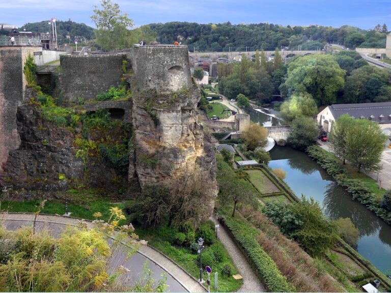
The Bock promontory preserves the setting of the early castle and later defensive works. The medieval city wall followed the line of the present Rue du Fossé, while a second enceinte, or enclosing wall, incorporated the Rham Plateau. A later wall extended toward the present Boulevard Royal. The castle bridge, Spanish turrets, Vauban’s towers, the Three Towers, and the Bock and Pétrusse casemates form part of the surviving defensive landscape.
Gates and Access Works
The medieval city had 23 gates and relatively open movement between the town and countryside. As the fortifications expanded from the sixteenth century, access became more restricted. The Marie Gate was buried beneath Bastion Marie in 1548, while the Lampert, Orvis, Beckerich, and Jost gates disappeared beneath the Berlaimont, Louis, Beck, and Jost bastions in the early seventeenth century.
The Jews’ Gate, the principal western access for trade with the Netherlands, was closed in 1644. Traffic was redirected through the New Gate, or Porte-Neuve, constructed between 1626 and 1636. The expanded defences also included the bastions and curtain walls along the present Boulevard Franklin D. Roosevelt and Boulevard Royal, the widened ditch, and the ravelins added during the sixteenth-century modernisation.
Advanced Forts and Surviving Works
Vauban and Austrian Fortifications
The advanced works associated with Vauban included the crownwork at Niedergrünewald, the hornwork at Obergrünewald, the Corniche de Verlorenkost, Fort Bourbon, several redoubts, and large barracks on the Rham and Saint-Esprit plateaux. Austrian expansion added the lunettes and exterior forts of Olizy, Thüngen, Rubamprez, Rumigny, Neipperg, Wallis, Rheinsheim, and Charles. Locks closed the valleys, and extensive casemates were cut into the bedrock beneath the Bock.
Fort Thüngen
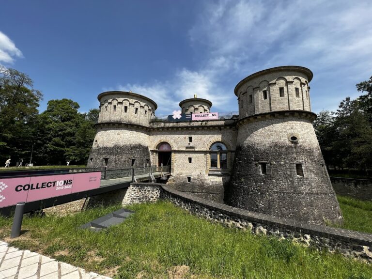
Fort Thüngen on the Kirchberg Plateau was heavily restored and now houses the Museum of the Fortress, the Museum Draï Eechelen. Its three towers gave rise to the nickname “Three Acorns.” The fort remains one of the clearest surviving examples of the later defensive system.
Fort Lambert and Bastion Beck
Fort Lambert, on the front facing the plain, was covered with earth after 1867. Avenue Monterey was later built over the site, and construction of an underground car park in 2001 uncovered part of the fort, including one of its redoubts. That surviving section is visible to the public. Bastion Beck now forms the site of Place de la Constitution, where the Gëlle Fra memorial statue stands. Villa Louvigny was built on the remains of Fort Louvigny.
Wenceslas Wall and Other Surviving Elements
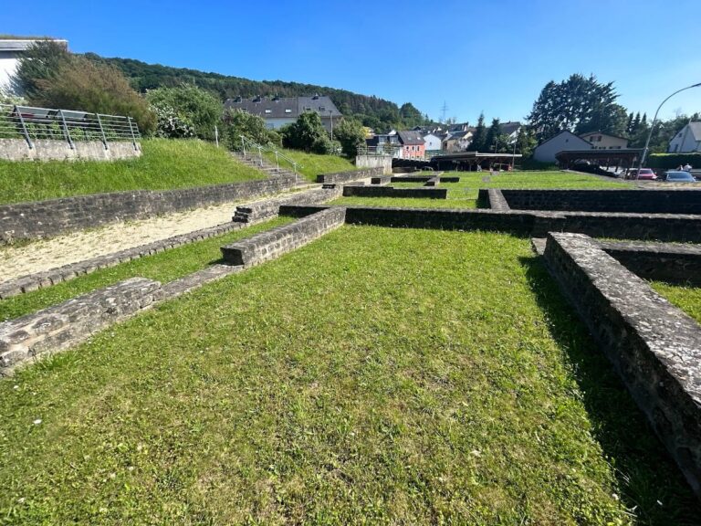
Other surviving or partly surviving elements include towers on the Rham Plateau, the Wenceslas Wall, the former cavalry barracks at Pfaffenthal, the Holy Ghost citadel, and the former castle bridge. The Wenceslas and Vauban circular walks follow surviving sections of the fortifications. Many streets and buildings preserve the names of former works, including Fort Rheinsheim, Fort Dumoulin, Fort Olizy, Fort Bourbon, Fort Elisabeth, Fort Wallis, Fort Neipperg, Fort Wedell, Fort Berlaimont, Fort Niedergrünewald, Fort Thüngen, and the former New Gate.
Barracks, Stables, and Military Infrastructure
Accommodation and Hospital
The military accommodation included the Piquet Barracks, Porte-Neuve Barracks, the barracks on the Rham and Saint-Esprit plateaux, the Rham Barracks, the Maria Theresa Barracks, and the riding barracks. The military hospital at Pfaffenthal had capacity for 200 men in 1774. These buildings formed part of the fortress’s effort to house troops within the defensive system rather than relying entirely on civilian dwellings.
Stables and Riding Arena
Parts of the Rham and Maria Theresa barracks and the riding barracks became stables in 1814. A former grain and flour store in the upper town was also used for horses, giving the facilities a combined capacity of 386 animals. The covered riding arena completed in 1835 on the lower court of the Saint-Esprit Plateau was large enough to train a squadron. In wartime, it could be used as a livestock shed or fodder store.
The Cavalier Camus contained a mill that required 24 horses and produced flour for 1,500 portions of bread. After 1814, oats were stored in surviving churches, while straw was kept in trenches and lower quarters because of its fire risk. These installations show how the fortress’s physical layout accommodated transport, food production, animals, and military supply.
Archaeology, Conservation, and Historical Representation
Archaeological and Conservation Work
The National Centre for Archaeological Research investigated the Wenceslas Wall from 2003 to 2008. Restoration followed from 2010 to 2014, and the restored area was inaugurated in 2015. Excavations at Fort du Moulin in 2008 and 2009 exposed substantial remains that were later re-covered. Archaeological analysis of parts of Fort Rumigny took place in 2011 and 2012 during construction of the Sportlycée.
The former French Redoute de la Bombarde, later the Réduit Rumigny, was restored and converted between 2000 and 2017. It became the seat of the Friends of the History of the Fortress of Luxembourg association. These interventions preserved parts of the complex while revealing the changing forms of its defensive works.
Maps, Images, and Urban Memory
The fortress and city were repeatedly represented in maps, engravings, paintings, watercolours, and sketches. The oldest known view of Luxembourg City is a copper engraving published by Georg Braun and Frans Hogenberg in 1598. Joan Blaeu published another view in 1649. Later views and studies were produced by Van der Meulen, Christoph Wilhelm Selig, Jean-Baptiste Fresez, J. M. W. Turner, Johann Wolfgang von Goethe, Michel Engels, Nicolas Liez, Joseph Kutter, and Sosthène Weis.
The old fortifications and the city’s old quarters were inscribed together in 1994 as the UNESCO World Heritage Site “City of Luxembourg: its Old Quarters and Fortifications,” reference 699. The inscription recognises the cultural value of the surviving urban and defensive ensemble under criterion (iv).
Nearby sites