Fort du Lomont: A Séré de Rivières Fortification in France


Site at a Glance
- Rating
- 3.4
- Popularity
- Very Low
- Country
- France
- Primary era
- Modern
- External website
- Open
- Eras represented
- Modern
- Civilizations
- French
- Site type
- Military
- Remains
- Fort
On this page7 sections
History
Fort du Lomont is a French fortress built between 1875 and 1878 as part of the Séré de Rivières system, a network of fortified positions created after the Franco-Prussian War. It stands on the summit of the Lomont chain and formed part of the Lomont defensive position within the fortified system of eastern France. Its main purpose was interdiction fire, using artillery to control approaches across the surrounding area.
Construction and defensive organization
The Adrien Hallier construction company built the fort between 1875 and 1878. It was briefly known as Fort Baraguay d’Hilliers. The position extended across the communes of Chamesol, Montécheroux, and Pierrefontaine-lès-Blamont. Its stated armament consisted of 73 rampart guns, 18 mortars, and 22 flanking pieces. A supplementary powder magazine was excavated beneath the rock in 1889.
Fort du Lomont communicated with the forts of Lachaux, Mont Bart, and Montfaucon through optical telegraphy, which transmitted signals by light rather than through physical cables. The fort was later affected by modernization plans. The 1900 restructuring program was left incomplete, while a supplementary program planned for 1908 was not undertaken.
Mobilization and the Second World War
From 1935 to 1939, the fort served as a regional mobilization center. A company of the 35th Infantry Regiment initially occupied it, and this unit was later reorganized as the 21st Battalion of Foot Chasseurs. In September 1939, the 159th Foot Artillery Regiment took up position there. German forces outflanked the regiment in June 1940, after which the occupying authorities converted the fort into an anti-aircraft defense post.
On 6 September 1944, the maquis, rural French Resistance groups that fought the German occupation and its collaborators, took control of Fort du Lomont. The fort then served General Jean de Lattre de Tassigny as a base for the Doubs Offensive. That operation contributed to the liberation of Montbéliard, Héricourt, and Belfort and to the advance of French forces toward the Rhine. The Séré de Rivières system, of which Fort du Lomont formed a part, had first been used as a defensive organization during the First World War.
Remains
Overall layout and accommodation
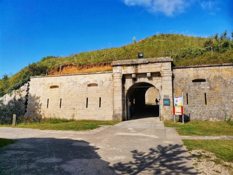
Fort du Lomont is arranged as an outer enclosure, or envelope, about 1.5 kilometres long. This enclosure surrounds a central redoubt to the south and a substantial battery to the north. The redoubt contained barracks for 420 men, while the northern battery accommodated 366. Peace-time barracks for another 160 men were later built between the two sections. An annex battery stood to the east, near the Lomont farm. The stated garrison strength was 2,646 men.
Entrances and ditch defenses
A drawbridge crossed the outer envelope, and a second bridge gave access to the redoubt. The northern battery had a single caponnière, a covered defensive structure projecting into a ditch so that the ditch could be swept by fire. The redoubt contained two double caponnières and one triple caponnière, forming its principal arrangements for defending the surrounding ditch.
Battery and communications structures
An optical post stood near the northwestern salient of the northern battery. It used light signals to communicate with other fortified positions. The fort’s later physical development remained limited because the planned restructuring was not completed, leaving its original nineteenth-century defensive organization as the basis of the surviving complex.