Fort de Pugey: A Late-Nineteenth-Century French Fortification near Besançon


Site at a Glance
- Rating
- 4.8
- Popularity
- Very Low
- Country
- France
- Primary era
- Modern
- External website
- Open
- Eras represented
- Modern
- Civilizations
- French
- Site type
- Military
- Remains
- Fort
On this page17 sections
History
Fort de Pugey is a late-nineteenth-century French fortification in France, built between 1890 and 1892 as part of the fortified camp of Besançon. It belonged to the Séré de Rivières system, a national programme of fortified belts and defensive works established under General Raymond Adolphe Séré de Rivières. The fort formed part of the camp’s second expansion, carried out from 1888 to 1893, which extended the defensive perimeter eastward and southward.
Construction and defensive role
The fort was projected in 1879 and constructed on the ridge separating Pugey from Larnod. Positioned in front of Arguel and Planoise, it completed the approximately 50-kilometre fortified belt around Besançon. Its principal tactical purpose was to create crossing fire with the nearby Rolland Battery and Fort de Planoise. A separate three-gun battery faced south, toward a possible approach from the direction of Quingey and the plateau.
Pugey was designed for a garrison of 176 men, comprising 160 infantrymen and artillerymen, 12 non-commissioned officers, and four officers. In 1914, the recorded garrison numbered 122 men and was organized as a fortress battalion. The fort’s arrangement reflected the changes in artillery during this period, when protected gun chambers and buried installations were intended to withstand increasingly powerful explosive shells.
Armament and modernization
In 1893, the armament consisted of two 95 mm guns in the eastern casemates, two 155 mm C guns in the western casemates, three 120 mm L guns in the upper battery, and three revolving cannons for defending the ditches. A revolving cannon was a rapid-firing weapon with several barrels, used here to sweep the ditches with fire. The listed armament in 1895 comprised two 155 mm C guns, four 120 mm guns, six 95 mm guns, and three revolving cannons.
Between 1892 and 1914, three battery positions were installed north of the fort along the cliff edge. Their weapons changed over time. By 1912 to 1914, the deployment included four 95 mm guns on siege-and-position carriages, three 80 mm guns on field carriages, four smooth-bore mortars in an auxiliary battery, three 120 mm L guns in the upper battery, three revolving cannons, and five 40 mm tubes. The 80 mm de Bange gun was a French breech-loading field-artillery design associated with the modernization of late-nineteenth-century artillery.
Unlike the camp’s other principal fortifications, Pugey was designed after the shell crisis of 1885 as a largely buried, cavern-like work rather than as a conventional polygonal fort. The rooms lay beneath a substantial covering of rock, intended to reduce the effects of melinite, a powerful high-explosive shell filling used by late-nineteenth-century artillery. The planned modernization of 1900 and the complementary programme of 1908 were never carried out. Pugey had no armoured turret, Bourges casemate, or observation post.
War, occupation, and later use
The fort did not experience combat and was downgraded and decommissioned during the 1920s. During the German occupation, the resistance group Guy Mocquet used it intermittently. In 1940, members trained there on Sundays with weapons recovered during the French defeat. In March 1942, they tested improvised bombs in the entrance ditch and in one of the gun caves. German troops later carried out firing exercises against the gun embrasures facing the village, leaving impact marks.
After the Second World War, local residents removed materials from the former artillery shed and caretaker’s house beside the rainwater-catchment area. The north ditch was used temporarily as a municipal dump before being filled. In the 1970s, one casemate was physically altered for use as a mushroom farm. The municipality of Pugey acquired the land in the late 1950s for 380,000 old francs. The fort now belongs to Pugey, while the separate powder magazine belongs to Larnod.
Clearance and preservation
Rubble clearance and vegetation removal began in 2009 through joint work with AVALFORT. Guided visits were subsequently established, and a temporary lighting circuit was installed. The fort has been open for Heritage Days since 2012, while a local association was formed in 2024. In 2019, for AVALFORT’s tenth anniversary, three residents of Pugey made and inaugurated a full-size model of the 80 mm de Bange gun used in the fort’s defensive deployment in 1914.
An attempt by the 19th Engineer Regiment to clear the north ditch in 2014 was unsuccessful. Ventilation pipes were later installed for the barracks and entrance hall. The underground section is secured by grilles, so the fort’s current use is limited to guided visits and occasional events rather than independent access.
Remains
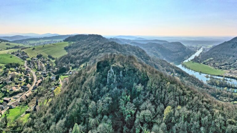
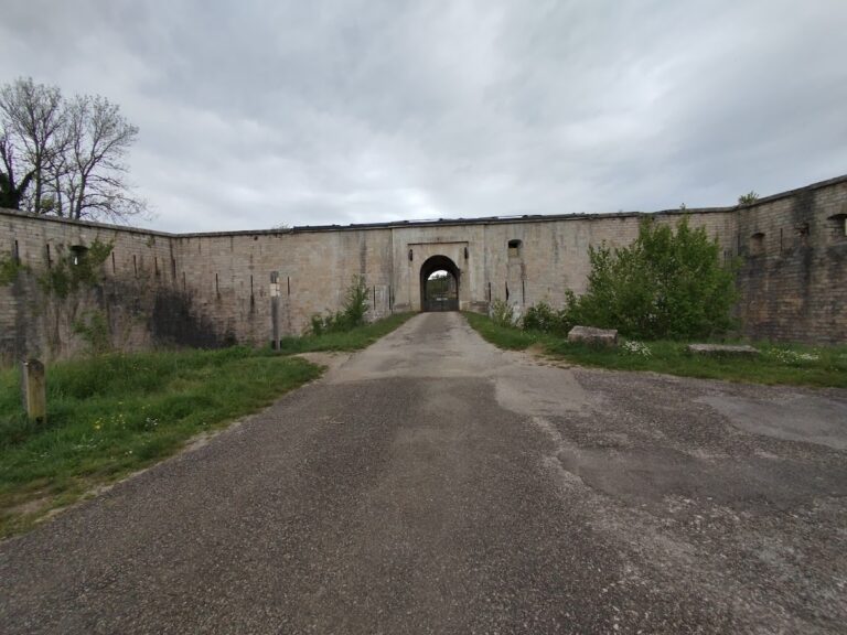
Fort de Pugey occupies a ridge about 100 metres wide between Pugey and Larnod, at an altitude of 494 metres. The southern side forms the head front, facing a potential enemy approach from Quingey and the plateau, while the entrance lies on the gorge front. The fort is set approximately 10 metres below the surface, with at least six metres of rock above its underground rooms. Its visible defensive position includes ditches around a battery position, a protected wall-walk with a crenellated wall, and a parade ground.
Surface defenses and entrance
Ditches and flanking casemates
The ditch system follows the ridge and its irregular ground. There is no eastern ditch because of the cliff. The western ditch stands higher than the gun-cave embrasures and is interrupted for approximately 20 metres. The distance from the northern to the southern ditches is only 70 metres. The north ditch has been filled, while the broader south ditch is divided by an earth embankment carrying the path through the fort.
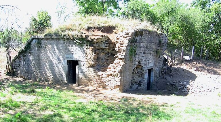
Several ditch defenses remain partly visible. They include the flanking casemate of the south ditch, the base of a small bastion defending the west ditch, and the upper part of the flanking casemate of the north ditch. A flanking casemate is a protected gun chamber projecting into a ditch, performing a modernized version of the function once associated with a caponier. An infantry parapet overlooks the interrupted section of the west ditch above the casemated gun embrasures.
Gorge entrance
The main entrance was opened at the bottom of the gorge ditch and protected by a low ditch. A narrow staircase, known as a mouse-step, reached it along the counterscarp wall, the outer side of a fortification ditch. A laterally retractable bridge protected the entrance, and its internal position remains visible. The filled north ditch has blocked the main doorway, leaving the staircases and gun embrasures as the only possible routes into the interior.
Parade ground and staircases
Earth embankments bound the parade ground. Two spiral staircases descend from it to the underground level, each containing approximately 50 steps and protected by a concrete dome. These domes, the ditch-flanking casemates, and the firing embrasures of the gun caves were built in a recently developed special concrete. The concrete above the casemates and domes is between two and 2.5 metres thick.
Underground organization
The underground installation is arranged around two corridors meeting at right angles. The north-south corridor extends from the entrance at the bottom of the ditch. It leads to two gun caves intended to fire approximately four kilometres eastward, a small ammunition store, a latrine area, and a second double flanking casemate with positions for two revolving cannons. This casemate defended the enemy-side ditch, which was five metres wide at its base.
The same corridor contains a broad stairway to the lower level and access to the north flanking casemate, which held a revolving cannon. The retractable bridge was adjacent to this access. At the other end of the installation, the east-west corridor serves five casemates measuring 12 by 4 metres. A casemate is a protected chamber intended for guns or other military use.
Barracks and service rooms
The first of the five casemates was divided into three rooms, probably an infirmary with eight beds or an officers’ room, together with a lamp room and a provisions store. The other four served as barracks. Each was designed for 44 men in basic conditions, with two rows of metal bunks covered by straw mattresses, an air shaft, and a stove. A small passage midway along the corridor leads to one spiral staircase and the officers’ room.
Brick lining was applied to the walls of the barracks, stores, and parts of the corridors to improve insulation and channel water seepage. Most of this lining was destroyed during the occupation. German troops are thought to have stripped the fort’s metal elements, including doors and frames, bunks, and the carriage of the retractable bridge. The remaining construction is mainly masonry, with vaulted underground rooms and corridors.
Gun caves and firing positions
At the far end of the east-west corridor are a room and two further gun caves. Their guns were oriented toward the northwest, with a range reaching beyond the Doubs meander at Aveney, approximately four kilometres away. The exposed firing embrasures were made from the same special concrete used in the other protected elements. Impact marks from German firing exercises remain on the embrasures facing the village.
Stone removed during the cutting of the ditches and underground chambers was reused in the masonry. Additional material came from municipal quarries several kilometres away. Parts of the escarp, the inner side of a ditch, and counterscarp were supported by walls, while other sections consisted of natural rock or earth. The underground corridors extend for approximately 150 metres, and the former lighting was supplied by oil-burning fortress lanterns.
Water supply and detached structures
Rainwater installation
Beside the north ditch lies the rainwater installation known in military terminology as the Rouby source. Its catchment area covers 9.5 ares. Water passed through a grass-covered filter area into an underground cistern cut into the rock. The cistern held 300 cubic metres, and the water was mineralized to make it potable.
External powder magazine
The external powder magazine lies 700 metres from the fort beneath Larnod’s present water tower. Cut into the rock in 1889, it contains two rooms capable of storing 24 tonnes of explosives and a guardhouse. Boundary markers for the land acquired for the fort and magazine remain in place.
Former support buildings
The artillery shed and caretaker’s house once stood beside the rainwater-catchment area. Their materials were removed after the Second World War. The surviving escarp and counterscarp have since become severely degraded after decades without maintenance. The filled north ditch and the casemate altered for mushroom cultivation remain part of the fort’s later physical history.
Nearby sites