Fort de Bellegarde: A Frontier Fortress above Le Perthus


Site at a Glance
- Rating
- 4.3
- Popularity
- Low
- Country
- France
- Primary era
- Early Modern
- External website
- Open
- Eras represented
- Medieval, Early Modern, Modern
- Civilizations
- French, Kingdom of Majorca, Spanish
- Site type
- Military
- Remains
- Fort
On this page14 sections
History
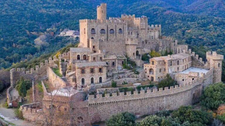
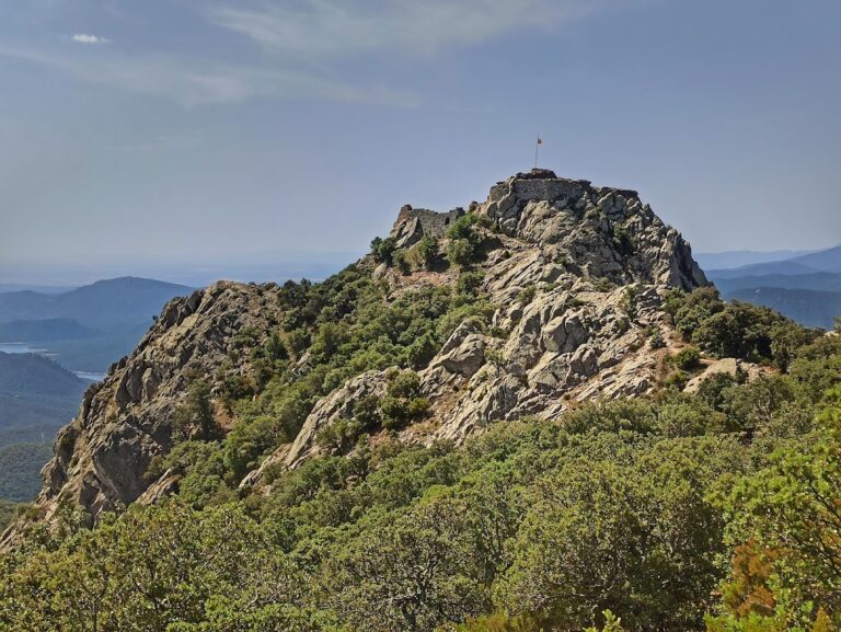
Fort de Bellegarde is a seventeenth-century fortress in France above Le Perthus, developed to control the Col du Perthus and defend the route into the country. Its origins reach back to 1285, when James II of Majorca built a self-defensible observation tower on the frontier. The later fortress belonged to a long history of conflict between the crowns of Majorca, Aragon, France, and Spain, and also served as a customs point where travelers were charged tolls.
From medieval tower to French frontier stronghold
James II ordered the tower’s construction while threatened by Peter III of Aragon. After Aragon gained the military advantage during the fourteenth century, the royal administration abandoned the tower. The local lord then used it mainly to collect tolls. Following the failed Aragonese crusade, James II was required to cede the fortification to Aragon.
The Treaty of the Pyrenees in 1659 transferred Le Perthus to France and prompted the first expansion of the fortification under French control. During the Franco-Dutch War, Spanish forces captured Bellegarde on 8 May 1674. French troops commanded by Count Frédéric-Armand de Schomberg retook it on 29 July 1675 after a ten-day siege. The Spanish had strengthened the fort during their occupation.
Vauban’s enlargement
In 1679, Sébastien Le Prestre de Vauban, Louis XIV’s principal military engineer, visited Bellegarde and approved a major enlargement proposed by his engineer Christian Rousselot de Monceaux. Vauban also required corrections, including a double defensive system. The marquis de Louvois, Louis XIV’s war minister, accepted most of the project in 1680, and the works were carried out. The resulting fortress gave France a fortified position over the pass and the road leading through it.
Revolutionary and modern military history
During the War of the Roussillon, a conflict between revolutionary France and Spain, General Ricardos led a Spanish offensive into Roussillon. Spanish forces occupied Prats-de-Mollo on 25 May 1793, took Fort Lagarde on 5 June, and captured Bellegarde on 25 June. French troops under General Jacques François Dugommier recaptured the fortress in September 1794 after a siege.
Dugommier died at Figueras on 17 November 1794. His body was brought to the fort before being moved elsewhere, and a monument commemorating him replaced the original memorial associated with his remains. During the Revolutionary period, the fortress was temporarily renamed Fort de Midi-Libre, or Fort Sud-Libre, alongside the republican renaming of Condé as Fort Nord-Libre.
In January and February 1939, during the Retirada, the mass flight of Spanish Republicans into France at the end of the Spanish Civil War, Bellegarde served as an internment camp for refugees fleeing the advance of Franco’s forces. During the Second World War, the Gestapo, Nazi Germany’s secret state police, used the fort as a prison for recaptured escaped prisoners of war, Spanish Republican refugees, and people who helped others cross the border.
Fort de Bellegarde has been protected as a French historic monument since 26 June 1967. The commune of Le Perthus owns the site and has progressively restored it. Its present uses include a small exhibition devoted to the fort’s history and the archaeology of the Col de Panissars, as well as art exhibitions.
Remains
Fortified enclosure and outer defenses
Bastions, walls, and ditches
The fortress occupies an approximately pentagonal plan on a summit about 423 metres above sea level. Its glacis, a gently sloping area intended to expose attackers to defensive fire, extends for approximately 1 kilometre. Five connected bastions, projecting platforms designed to provide flanking fire along adjoining walls, protect the main enceinte, or enclosing defensive wall. Behind this rampart, a second interior wall shields the fortress core, producing three defensive levels formed by the bastions, the ramparts, and the inner protective wall.
The double masonry enceinte was largely surrounded by a dry ditch. A wet ditch between two bastions further protected the gorge, the rear or landward side of a bastion or outwork. Fieldworks reinforced the glacis at the south-eastern corner and along the eastern and northern fronts. Elsewhere, flatter slopes required heavier advanced defenses.
Hornwork and approach defenses
The southern ridge facing Spain was closed by a hornwork, a projecting outer defense formed around a central curtain by flanking works. A covered way, meaning a protected passage along the outer edge of a ditch, connected the hornwork with the fort. Ravelins, outworks placed in front of a fort’s walls or entrance, protected the south-western, southern, and western approaches. A northern ravelin appears on Rousselot de Monceaux’s plan but was never built.
Porte de France
The sole entrance was the Porte de France. A crescent-shaped fortification protected it, while an access ravelin reached by a ramp led to a masonry bridge. At the main entrance, the bridge was interrupted by a drawbridge. Together, these structures controlled passage into the fortified interior.
Fortress core and surviving buildings
Barracks and service buildings
The fortress core contained barracks for a garrison of up to 600 men, along with a chapel, hospital, bakery, mill, and well. Some barracks were incorporated into the hornwork and are now ruinous. The southern barracks are also in ruins. The site’s surviving architectural elements include courtyards, bridges, defensive ramparts, the chapel, hospital, bakery, mill, barracks, hornwork, ravelins, bastions, ditches, and glacis.
Chapel
The chapel measured 11.20 metres in width and originally reached 12.50 metres in height. During the nineteenth century, it was divided into two levels, reducing its internal height. This alteration remains part of the building’s later physical history.
Saint-André Bastion well
A well was dug in the Saint-André Bastion in 1698. It is approximately 6 metres in diameter and 62 metres deep, and was designed to provide enough water during a prolonged siege. Its position within a bastion formed part of the fortress’s arrangements for sustaining the garrison under attack.
Boundary marker
The fort’s main courtyard contains former boundary marker number 569. It once stood near the military cemetery at the Col de Panissars. A replacement granite marker now occupies its original location, while the former marker remains within the fortress.
Nearby sites