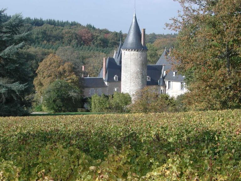
Ensemble castral de Vesvre: A Fortified Complex in France


Site at a Glance
- Rating
- 4.4
- Popularity
- Low
- Country
- France
- Primary era
- Medieval
- External website
- Open
- Eras represented
- Medieval, Early Modern
- Civilizations
- French
- Site type
- Military
- Remains
- Castle
On this page17 sections
History
The Ensemble castral de Vesvre is a fortified complex in France, at Neuvy-Deux-Clochers in the Cher department, occupying a central position in the Pays-Fort region of Berry. It stands in the damp valley of the Tour stream at about 250 metres above sea level, an unusual setting for a castle because the site was not placed on a height. The complex developed from the late ninth century through the eighteenth century and was closely connected with the route between Bourges and Sancerre.
Early occupation and territorial control
Occupation began by the end of the ninth century. The earliest activity included craft workshops and agricultural exploitation, although its exact location is unknown. Waste from these activities accumulated on the site and was later reused during successive building and landscaping phases. A raised platform requiring at least 3,000 cubic metres of fill was occupied for approximately three centuries. The early castle mound and medieval bailey may have formed part of this arrangement, though their contemporaneity cannot be demonstrated.
Vesvre’s position appears to have been chosen in relation to movement through the surrounding territory. A route crossed the site before the castle was built, and the road between Bourges and Sancerre was later diverted when the complex was established. The site also lay near the boundary between the châtellenie of Les Aix-d’Angillon, a territorial lordship administered from a castle, and the seigneurie, later county, of Sancerre. Until the end of the tenth century, it stood between the spheres of influence of the royal domain and the counties of Blois and Anjou. The lords of Vesvre shifted their political alignments according to opportunities and alliances.
The name Vesvre first appears in 1034, when Ébard and Godefroy used the designation “of Vabra.” Their overlords belonged to the Sully family, castellans of Les Aix-d’Angillon. Members of the Vesvre family later appeared repeatedly as witnesses in affairs involving the archbishopric and local abbeys. They seem to have lived on or beside a castle mound. By the mid-twelfth century, Eudes and Hugues II were lords of Vesvre, and their family controlled lands extending approximately 45 by 35 kilometres between La Chapelle-d’Angillon, La Charité-sur-Loire, Sancerre, and Menetou-Couture. It remains uncertain whether Vesvre was the family’s only residence.
The tower and the divided lordship
At the beginning of the thirteenth century, two children of Hugues II appear to have divided the domain. Hugues III held the tower, while Eudes II held the mound. A traditional attribution made by nineteenth-century scholars credited the tower to Hugues II, but the combined historical and archaeological evidence has challenged that interpretation. Hugues II may have begun the work before his death at the end of the twelfth century, while completion probably took place at the beginning of the thirteenth century.
Documents reveal that the complex contained distinct lordly elements. A record from 1344 mentions “the mound and old hall of the Bois de Vèvre,” while documents from 1363 to 1365 refer to a “tower of Vesvre.” The locations of these references are not certain, and the later mention may instead concern a tower at Germigny-l’Exempt in the Nièvre department. By the fifteenth century, however, records clearly distinguished two lordships at Vesvre, known as “the Mound” and “the Tower.”
A chapel dedicated to Saint Julien, a Christian saint, appears in records from the twelfth and seventeenth centuries. Its location is uncertain. It may have stood in the medieval bailey or on the raised platform, possibly against the northern side of the tower and connected to it. A description from 1683 also mentions a chapel, perhaps Saint Julien, and a dovecote on the platform.
Later traditions placed the foundation of Vesvre and Bourges in the fifth century. A written tradition from 1566 made this claim, while a now-lost inscription was said to have attributed the tower’s construction to “Gondobal” in AD 503. Archaeological evidence rejects both traditions and places the development of the complex much later, beginning with occupation in the ninth century.
Fifteenth- and sixteenth-century transformation
The complex was substantially reorganized during the fifteenth and sixteenth centuries. The tower’s interior was rearranged, while the eastern bailey, its fortified boundary, and the dovecote were constructed. This eastern sector became the new approach to the central raised platform. The changes altered both the defensive organization and the movement through the lordly residence.
The tower was remodeled again by the late eighteenth century, when farm buildings were added inside the bailey. The residential building attached to the tower continued to be modified during the nineteenth and twentieth centuries. It became unoccupied after the Second World War, deteriorated, and was demolished in the mid-1970s. Only one simply adapted room in the tower remained inhabited until 1961. The complex had otherwise been continuously occupied until the French Revolution.
Modern investigation and protection
After the tower’s last occupant died in 1961, the municipality of Neuvy-Deux-Clochers began acquiring parcels of the site. By 2012, it owned the parcels containing the mound, tower, farm, and dependencies. Architectural investigation of the tower began in 1998 before repairs to its roof structure and covering. Preventive excavation from 2004 to 2006 preceded work on the foundations of internal dividing walls and the consolidation of the tower’s exterior walls. Surveys, excavations, and building studies continued during restoration work on the barn in 2010 and 2011 and the dovecote in 2013 and 2014.
In 2012, the research project “Birth and Development of the Vesvre Castral Complex” brought together twenty archaeologists, archivists, and historians. Its first synthesis was published in 2025. The complex has been protected as a French historic monument since 1991 and classified since 2008. The municipality of Neuvy-Deux-Clochers is its current owner.
Remains
Enclosure and medieval earthworks
The complex covers approximately 6.5 hectares and contains features from several periods. A ditch about 8 metres wide encloses the entire site, and its course remains visible in places. The mound has a separate ditch that geophysical survey shows was connected to the bailey ditch. In some early areas, the ditch may have been formed mainly by raising the structures alongside it rather than by excavating the channel.
Outside the ditch, a defensive earthen bank protected the complex. A short section survives about 15 metres from the ditch on the northern side, while on the southern and eastern sides the bank lies farther away. The modern Vesvre road appears to follow its outer line. At the northern edge, an artificial mound measuring about 10 by 7.5 metres rises slightly more than 2 metres above the ditch. Made from stones, pebbles, and earth, it may have supported a vanished structure, possibly a wooden footbridge. It provided a northern approach to the raised platform, where the peripheral bank breaks to allow a path.
Castle mound
The castle mound is a truncated-conical earthwork about 50 metres in diameter at its base and approximately 10 metres high. Its construction may have required around 5,000 cubic metres of fill, partly composed of waste from occupation and woodland clearance. The summit forms a platform about 20 metres across. It occupies the south-western corner of the medieval bailey, on the side considered most vulnerable to attack because the ground outside the enclosure rises progressively.
Geophysical survey detected the remains of a possibly masonry building in the northern part of the summit. Its function and date remain uncertain, and an attribution to the beginning of the thirteenth century is particularly tentative. Its markedly eccentric position suggests that other structures may have occupied the open area farther south.
Medieval bailey
The oval medieval bailey measures approximately 150 metres along its major axis and up to 100 metres across. Its construction may have required about 21,000 cubic metres of earth and other materials. Geophysical anomalies indicate buildings within the enclosure. The bailey was also associated with an agricultural settlement or estate, called the “town of Vesvre” in 1274. The medieval term villa in this context meant an agricultural holding.
The northern part of the bailey was later filled, leaving a shallow depression that holds water during winter. By the seventeenth century, an old plan showed only the southern part of the ditch. The mound and bailey therefore preserve the outline of an early fortified and agricultural arrangement that was subsequently altered by the later complex.
Raised platform and central residence
The raised platform occupies the north-eastern part of the complex. It is roughly square, about 40 metres on each side, and stands slightly higher than the surrounding ground. A broad but shallow ditch separates it from the rest of the site. A sixteenth-century description referred to “double ditches.” The platform was first developed around the beginning of the tenth century and enlarged with additional fill in the late twelfth century, immediately before construction of the tower.
The platform was probably enclosed by a defensive wall with towers. Surviving elements include the wall bordering the ditch on the south and a guardhouse at the south-eastern corner. Early layers contain evidence of craft activity. Access originally came from the north, but it was later transferred to the south, where the eastern bailey served as an entrance passage or intermediary enclosure.
Vesvre tower
The tower is the dominant surviving structure. Built at the turn of the twelfth and thirteenth centuries on the remains of a considerably earlier residence, it measures 21 by 15 metres and reaches 27 metres to the top of its roof. Its rubble sandstone walls are about 2.50 metres thick. Numerous alterations have left it with four levels. Ten archaeological phases involving construction, alteration, or destruction have been identified at its location, extending from the late ninth century to the eighteenth century.
A major remodeling in the sixteenth century completely reorganized the interior and probably produced the present roof structure. At one stage, the tower was crowned by a crenellated wall-walk. The surviving fabric consequently combines the remains of an early residence, the medieval tower, and later changes to its internal and external form.
Residential building
Ruins of a residential building remain attached to the northern and western sides of the tower. It replaced an earlier structure that may have been contemporary with the tower. During the sixteenth century, it contained private apartments and their dependencies, which had previously occupied the tower. Numerous openings connected the two buildings.
The building was enlarged repeatedly toward the north and east, absorbing a perimeter tower and part of the curtain wall, the continuous wall joining fortified points. It probably contained service rooms such as a kitchen before being converted into a farm building. Its northern openings onto the esplanade formed part of the approach to the raised platform, reached by crossing the northern ditch from the artificial mound.
Eastern bailey and agricultural buildings
Eastern bailey
The eastern bailey lies between the southern ditch and the outer defensive bank. It may have been created at the same time as the tower, although its fortification appears to date mainly from the sixteenth century. Its enclosing wall reached the ditch of the raised platform and had a south-western entrance flanked by two small towers. One of these towers survives above ground.
Dovecote
The circular dovecote belongs to the alterations attributed to the late sixteenth century. Its interior walls contain almost 1,000 nesting niches, or boulins, extending from top to bottom. Three gun ports were inserted between the niches. These small openings could be reached from ground level inside the building and opened outward through the enclosing wall.
The arrangement gave the dovecote two functions, housing pigeons and providing a defensive installation. The precise purpose of the gun ports remains uncertain. They may have served practical purposes, and they may also have expressed the lord’s authority.
Farm
The farm is probably the latest construction on the site and dates to the eighteenth century. Its agricultural buildings, including a sheepfold or pigsty, a stable, and a barn, rest against the eastern bailey’s enclosing wall, curtain wall, or small towers. An old pond has been identified in the farmyard.
Materials and evidence of daily life
Local geological materials contributed to the construction of the complex. Saint-Doulchard marls from the Upper Kimmeridgian occur sporadically in the tower’s masonry and in the platform supporting it. Nearby Cretaceous formations supplied ferruginous sandstone for building, sand for glassmaking, clay for ceramics, and limestone for construction. The surrounding woodland included oak and hazel, which supplied timber, fuel, and material for woodworking. Nearby land was divided among cereal or root crops and meadows, while the wettest ground supported reed beds.
Food remains also indicate access to trade networks and differences in social status. Sturgeon dermal plates and oyster shells reached Vesvre from elsewhere because these species were not native to the region. Their consumption points to imported foods available to at least some of the people living at the complex.