Teichus (Teichos Dymaion): A Mycenaean Fortress in Greece
Site at a Glance
- Rating
- 4.2
- Popularity
- Very Low
- Country
- Greece
- Primary era
- Bronze Age
- External website
- Open
- Eras represented
- Bronze Age, Classical, Medieval, Modern
- Civilizations
- Ancient Greek, Byzantine, Italian, Mycenaean
- Site type
- Military
- Remains
- Fort
On this page16 sections
History
Teichus, also known as Teichos Dymaion, is a prehistoric settlement and fortress in Greece on Cape Araxos in the northwestern Peloponnese. The site entered the Mycenaean cultural sphere during the Late Helladic period and received a major fortification around 1300 BC. It is described as the only fortified Mycenaean acropolis discovered in western Greece. Later occupation connected the hill with the ancient city of Dyme, followed by Roman, Byzantine, and Venetian use.
Neolithic and Bronze Age settlement
Human activity on the hill began during the final Neolithic phase, in the fourth millennium BC. A substantial Early Helladic settlement developed there approximately between 3300 and 2000 BC, and occupation continued through the Middle Helladic period, around 2000 to 1600 BC. Pottery from the Early Helladic levels points to long-distance contacts with the central and eastern Mediterranean, including the Cetina culture of the western Balkans.
From Late Helladic IIB, in the fifteenth century BC, the region belonged to the Mycenaean cultural sphere. Teichus reached its greatest importance during the Late Mycenaean period, when a large defensive wall was built around 1300 BC. The settlement was probably a local princely center, meaning a smaller regional power rather than a palace administration. No Linear B records, frescoes, or extensive palace complex have been found, so the site is not classified as a Mycenaean palace center.
Its position supported connections across the western Mediterranean. A bronze dagger made in an Italian style and pottery probably produced in southern Italy belong to the Late Mycenaean finds. Related Mycenaean and Mycenaean-style vessels from Apulia and other parts of Italy also resemble pottery from the northwestern Peloponnese, indicating close commercial links between the regions.
Destruction and later prehistoric use
The settlement suffered a fire during the early part of Late Helladic IIIC, approximately between 1190/1180 and 1150 BC. It was rebuilt immediately and remained inhabited. The site appears to have been less severely affected than many Mycenaean palace centers during the upheavals around 1200 BC, or to have recovered quickly. Another destruction took place around the middle of the eleventh century BC, after which occupation may have become temporary or less intensive.
Recent work indicates continued activity during the Submycenaean and Protogeometric periods, approximately 1050 to 900 BC. The hill does not appear to have been permanently inhabited from the ninth to the fifth century BC, although a Geometric-period altar continued to serve cult purposes at least into the Hellenistic period.
Dyme and the Hellenistic fortress
The name Teichos Dymaion, probably already in use during the Hellenistic period, means the fortress of Dyme. Dyme was an ancient city and political community in Achaea, and Teichus probably stood within its territory during the Hellenistic and Roman periods. The connection is supported by a roof-tile fragment stamped with the name of Dyme.
Polybios, a Greek historian of the second century BC, described Teichos Dymaion as a fortress belonging to Dyme. During the Allied War in 219 BC, Euripidas, an Aitolian general, captured it. He later surrendered the fortress without a fight to the Macedonian king Philip V, who returned it to the inhabitants of Dyme.
Polybios also preserved a foundation legend that attributed the fortress to Herakles, the Greek hero associated with great strength and military exploits. According to the tradition, Herakles built it as a base during his war against the Eleians. This story is a mythic explanation of the site’s origins rather than an archaeological account of its construction.
Roman, Byzantine, and Venetian occupation
In Roman times, the site belonged to the Colonia Iulia Augusta Dumaeorum and may have been occupied by Roman colonists settled in the wider territory of Dyme.
Teichus was periodically and relatively densely occupied during the Byzantine period. Between the tenth and twelfth centuries, the older fortification was strengthened and partly enlarged. A northeastern tower was added, and a cross-wall divided the acropolis into two sections, although the purpose of this division remains uncertain.
The fortress continued in use at least into the Venetian period, when graves were placed on the acropolis. Venice controlled the area twice. During the second period, from 1685 to 1715, about 1,000 settlers from Lidoriki in Phocis reportedly moved into the surrounding area. The northern part of the acropolis may have served as a cemetery at this time. The fortress was no longer in use during the nineteenth century.
War damage and archaeological investigation
During the Second World War, Italian troops occupied the fortress as a military camp. Defensive installations caused extensive damage to the ancient buildings within the enclosure, and much of this destruction cannot be reversed.
Systematic excavations took place from 1962 to 1966 under Efthymios Mastrokostas, although the results were published only incompletely in preliminary reports. Further excavations were conducted between 1998 and 2009 under Lazaros Kolonas. Research has focused on the northeastern settlement area and, more recently, the northwestern fortifications. The interior remains only partly understood because the earlier work was incompletely published and later investigations covered limited areas.
Remains
Teichus occupies a hill approximately 40 to 50 metres high at the northern edge of the Prokopios Lagoon. The hill overlooks the Gulf of Patras to the north and the sea toward the Ionian Islands to the west. The surrounding lagoons and lakes, coastline, fertile farmland, woodland, and rocky ground supplied food, building materials, and natural protection. The Mycenaean enclosure followed the exposed northwestern, northern, eastern, and southeastern approaches, while the southwestern side was protected by the lagoon and a steep slope.
Mycenaean fortifications
Fortification wall
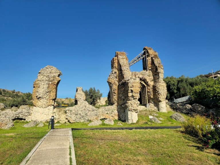
The main wall extends for approximately 295 metres. It is between 4.50 and 5.50 metres wide and survives in places to a height of 8.40 metres. Its construction uses large polygonal blocks, some weighing more than 3.5 tonnes, with smaller stones packed into the gaps. This is Cyclopean masonry, a monumental technique based on very large roughly shaped stones. Polybios gave the ancient wall a height of 30 cubits, equivalent to about 13.80 metres. The structure was repaired several times, including on the northern side, where medium-sized limestone blocks were added without mortar.
Gates and southeastern bastion
Three entrances served the enclosure. The principal gate stood on the southeast, while two others opened on the north and northwest. The northwestern entrance has been destroyed. Soon after the wall was built, a bastion-like addition strengthened the southeastern gate. It measures 8.80 metres along its northeastern side, 9.80 metres along its southeastern side, and 4.20 metres in width.
The bastion was originally constructed entirely from Cyclopean masonry. After much of it collapsed during the Byzantine period, its upper part was rebuilt with thin stone slabs, bricks, and lime mortar. The reconstruction retained the earlier dimensions and had rounded corners, allowing the later defensive work to remain tied to the form of the Mycenaean structure.
Settlement areas and later buildings
Mycenaean buildings
The prehistoric and ancient buildings inside the enclosure are only partly known. Neolithic activity is represented mainly by pottery. Early Helladic levels include traces of buildings, while Middle Helladic deposits contain mostly pottery and slight remains of wall foundations.
The northwestern part of the Mycenaean settlement was densely built. Excavation exposed small buildings with one or two rooms, at least some of which served as storage spaces. Narrow streets separated them. The excavated phases cover more than three centuries and include the complete Late Helladic IIIB and IIIC periods, approximately 1300 to 1040 BC.
Hellenistic and southern remains
Several Hellenistic building fragments and abundant pottery were found northwest of the main gate. Building remains and Mycenaean pottery also occur on the southern side of the hill, probably representing a settlement directly connected with Teichos Dymaion.
Altar and cult evidence
Southeastern altar
An altar stands directly beside the southeastern main gate. It consisted of a pedestal on a stepped base, or crepis, made from rough limestone slabs projecting from a leveling layer that reached 12 centimetres in thickness. Each step is approximately 0.28 to 0.30 metres high.
Although the altar was once assigned to the Geometric period, finds indicate that cult activity had already taken place at the location during the Mycenaean period. Votive inscriptions carved on the large fortification blocks behind the altar date to the fourth or third century BC. They refer to Aphetos, an epithet of Apollo, Enyalios, a war-associated deity or epithet linked with Ares, Artemis, and probably Aphrodite.
Objects and Mediterranean connections
Among the finds is a Pertosa-type dagger with a flange-shaped bronze hilt and an ivory-covered handle. It dates to the early twelfth century BC and reflects contact with Italy. Handmade burnished pottery probably made in southern Italy was also recovered. Comparable Mycenaean or Mycenaean-style pottery from Apulia and other Italian regions has close parallels with vessels from the northwestern Peloponnese, including both imported and locally made examples.
Nearby sites