Château de Montmayeur: A Medieval Fortified Castle in France


Site at a Glance
- Rating
- 4.4
- Popularity
- Very Low
- Country
- France
- Primary era
- Medieval
- Eras represented
- Medieval, Early Modern
- Civilizations
- Duchy of Savoy
- Site type
- Military
- Remains
- Castle
On this page13 sections
History
Château de Montmayeur is a former medieval fortified castle in Saint-Pierre-de-Soucy, France, begun during the twelfth or thirteenth century. It became the cradle of the Montmayeur family and the center of the lordship of Montmayeur, which was raised to county status in 1449.
Origins and the Montmayeur lordship
The castle was mentioned in 1173 as part of the dowry of Alix, daughter of Humbert III, Count of Savoy, in connection with her proposed marriage to John Lackland, the future King John of England. Count Thomas I of Savoy later granted the stronghold as an enfeoffment, a feudal grant of land or a fortified place with associated obligations, to a junior branch of the Briançon-Aigueblanche family. This branch adopted the name Montmayeur.
An act benefiting the Carthusians of Saint-Hugon, members of a contemplative Catholic order, was issued at the castle in 1212. Gérard de Briançon, the father of Aymon and Pierre d’Aigueblanche, held Montmayeur as a fief until his death in 1260. Around 1274, Aymé, or Aymon, de Montmayeur possessed a fortified residence there. His son Humbert, also known as Hugonet, inherited it and was living at the castle in 1355.
Refortification and the county
The two surviving towers were first mentioned in 1381. Gaspard II de Montmayeur, Marshal of Savoy, a senior military officer serving the Savoyard dynasty, remodeled the castle during Savoy’s general program of refortification, probably between about 1380 and 1416. The work gave the rectangular fortified enclosure towers at its four corners.
Gaspard’s son Jean, who died at Chambéry in 1433, held Montmayeur as well as the castles of Villard-Sallet, Briançon, and Cusy. Gaspard married Guigone de La Balme, the only daughter of the lord of Apremont, in 1417. He was succeeded by Jacques I de Montmayeur, who was also a marshal and a knight of the Order of the Collar, a chivalric order associated with the House of Savoy.
Jacques II de Montmayeur inherited the lordship in 1432. Born around 1405, he died at Montmayeur in 1487, and during his tenure the lordship became a county in 1449. He died without an heir in 1486 or 1487, after which his mother, Gilberte de Polignac, inherited the county. Through her marriage to Antelme de Miolans, it passed to the Miolans family and later to Jacques de Montmayeur de Creset.
Decline and destruction
The castle was abandoned at the end of the fifteenth century, and its towers deteriorated through lack of maintenance. Claudine de Miolans brought it as her dowry to the lord of Saint-Vallier in 1532. Four years later, the castle was described as no longer capable of being closed or defended.
Lesdiguières’ troops ruined the castle in 1597. Lesdiguières was the title of François de Bonne, a French nobleman and military commander. The settlement was then deserted in favor of Villard-Sallet, and the parish was suppressed.
The property later belonged to the Fausser, or Faussone, nobles. In 1664, Jean Faussone bequeathed the county to his eldest son, Blaise-Amédée Faussone, Count of Montmayeur. In 1728, the towers were held by Jean-Gaspard de Montmayeur, son of Jean Faussone, Count of Villanova, and Jeanne-Marie de Montmayeur, the last countess.
The Counts of Radicati sold the castle and its dependencies to the Marquis of Arvillard in 1758 for 65,000 livres, a historical French currency. The deed described the two towers as the remains of the former town and castle of the lords of Montmayeur. It also recorded surrounding building ruins, orchards, and scrub that had developed after the destruction of the settlement.
Setting and protection
Montmayeur occupied a surveillance and route-control position between the Gelon and Coisin valleys. From the Montraillant ridge, at about 800 meters above sea level, it overlooked the route from Chambéry toward Italy through the Maurienne and the Mont-Cenis.
The towers and associated archaeological site received protection as French historic monuments through an order dated 19 September 1989. In 1997, the site became part of the themed discovery route known as “Fortified Stones of Savoy.” The property is owned by the commune and remains in ruins.
Remains
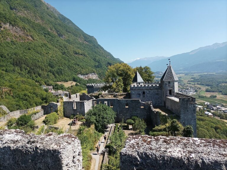
The surviving complex consists of a rectangular, ditched fortified enclosure oriented east to west. About 250 meters long and between 30 and 50 meters wide, it enclosed the castle and an associated settlement occupied from the twelfth to the fifteenth century. The enclosure had crenellations, alternating raised sections and openings along the top of its defensive walls, as well as arrow slits. Entry was from the north across a drawbridge.
Fortified towers
Eastern keep
The eastern square keep measures 7.60 meters on each side and has walls 1.90 meters thick. Built of squared schist rubble, it survives to a height of 33 meters and contains four floored levels. Its ground floor is blind. About 12 meters above ground, a doorway on the eastern side gives access to the first floor, while a small window provides the tower’s only other opening. The second level is also blind, and the summit is formed by a crenellated platform.
Western tower
The western tower stands on a platform separated by a ditch. Square in plan, it measures 8 meters on each side, retains a height of 25 meters, and has five upper storeys above the ground floor. Its crenellated top formed part of the defensive system. A round-headed doorway on the northern side provides ground-floor entry. A horizontal bar secured the entrance by sliding into openings cut within the thickness of the walls.
A small opening on the eastern face at first-floor level was probably a gun loop, a narrow opening for firearms. On the second level, two pointed-arch windows flank a fireplace with carved jambs. Each window is 0.40 meters wide and 1 meter high.
Residential and settlement remains
Residential range
At the foot of the eastern keep is a residential range containing a large hall from the thirteenth century. Two rooms were added in the former courtyard during the sixteenth century, providing evidence of continued building activity after the main medieval occupation.
Excavated settlement
Excavations between the two towers, which occupy opposite ends of the platform, exposed the foundations of one, or possibly two, fortified residences. The work also revealed a house and an oven beside a street, a rectangular enclosure, and a grain store at the foot of one tower.
Church of Saint-Julien
The church of Saint-Julien formed part of the settlement. It was mentioned in 1191 and depended on the Abbey of Saint-Rambert-en-Bugey.
The 1758 sale description placed the two towers about 50 toises apart, using a historical French unit of length. It described their walls as six feet thick and made from ancient masonry whose mortar was said to be as hard as stone. The remains of buildings, orchards, and scrub extended between and around the towers after the former town and castle had been destroyed.
Nearby sites