Château de l’Engelbourg: A Medieval Fortress in France


Site at a Glance
- Rating
- 4.5
- Popularity
- Low
- Country
- France
- Primary era
- Medieval
- External website
- Open
- Eras represented
- Medieval, Early Modern
- Civilizations
- Habsburg, Holy Roman Empire
- Site type
- Military
- Remains
- Castle
On this page18 sections
History
Château de l’Engelbourg is a ruined medieval fortress above Thann in France, built by the Counts of Pfirt between 1220 and 1230 to control the entrance to the Thur valley. Its position also enabled the lords of the castle to collect tolls from the long-distance route toward the Col de Bussang and Lorraine, which connected Italy with Flanders.
From the Old Castle to Engelbourg
Engelbourg succeeded an earlier fortification known as the Old Castle, whose exact location remains uncertain. Thann and the Old Castle had originally been imperial fiefs held by the Counts of Egisheim-Dagsburg. They later passed to the Counts of Pfirt, who appointed a bailiff, a local administrative and judicial official, to represent their authority.
The castle’s early history was shaped by disputes over lordship. In 1234, after the lord of the castle murdered his father, he was placed under imperial ban and his possessions legally reverted to the Empire. King Henry transferred his rights over Thann’s Old and New Castles to Berthold of Teck, Bishop of Strasbourg, in the same year. Emperor Frederick II confirmed that transfer in 1236.
The Counts of Pfirt subsequently regained control. In 1251, Ulrich of Pfirt made Engelbourg his allodial property, meaning land held outright, into a fief of the Bishop of Strasbourg and received it back from him. He had supported the bishop in his conflict with the Staufen, a medieval German ruling dynasty, since 1246.
The Principal Residence of the Counts of Pfirt
Engelbourg gradually became the preferred residence of the Counts of Pfirt. Around 1300, Count Theobald of Pfirt probably enlarged and remodelled it as his principal seat. The work included a substantial residential building, a new castle chapel first recorded in 1304, and a passage connecting parts of the complex.
The male line of the Counts of Pfirt ended in 1324. Through the marriage of Johanna of Pfirt to Duke Albert II of Austria, the County of Pfirt and Engelbourg passed to the Habsburgs, a major European ruling dynasty. The Habsburgs first administered the castle through bailiffs and later used it frequently as a pledged asset. From 1455 to 1563, it remained continuously in the hands of outside pledge-holders.
Military events also tested the fortress. Count Palatine Ludwig III took Engelbourg in 1415. Its garrison resisted sieges by the Armagnacs in 1444 and by Bernese troops in 1468. The name Engelburg first appears in written records in 1465. Its origin is uncertain, although it may have come from an early chapel dedicated to the Archangel Michael.
Pledging, Deterioration, and Repair
Under the Treaty of Saint-Omer in May 1449, Sigismund of Austria pledged the castle and other Habsburg possessions along the Rhine to Duke Charles the Bold of Burgundy for 50,000 gulden. Engelbourg was then pledged to Heinrich Reich of Reichenstein, before Charles redeemed it on 19 June 1470.
By 1470–1473, prolonged pledging had left the castle severely deteriorated. The roofs were in very poor condition, the defenses were ineffective, and the rooms had been emptied. Departing pledge-holders had removed furniture, windows, doors, hinges, and locks. Urgent repairs were estimated at about 380 gulden. Pierre de Hagenbach, the ducal bailiff at Thann, ordered essential work, but it did not fundamentally improve the fortress.
Engelbourg returned to Habsburg control in May 1477. In 1548, its condition was so poor that demolition of the keep was recommended. Comprehensive restoration began in 1571, after the pledges had ended. The bailiff and chaplain had to leave in 1577 because the castle had become deteriorated and uninhabitable.
Additional repairs took place in 1593–1601, 1614, and 1618–1621, with projected expenditure reaching 4,000 gulden. In 1617, Thann’s last castle bailiff moved into a newly built half-timbered house. The final major restoration campaign, completed by 1621, added a well and a new castle chapel.
War, French Rule, and Demolition
During the Thirty Years’ War, a conflict that reshaped political control across central Europe between 1618 and 1648, Engelbourg suffered severe damage. Thann changed occupiers seven times between 1633 and 1639, alternating between Swedish and French control. French troops took the castle permanently in 1654.
In 1658, Louis XIV, the French king who ruled from 1643 to 1715, gave the lordship and castle of Thann to his chief minister Jules Mazarin. Mazarin’s family retained ownership until the French Revolution. Repairs were still being made in 1672, although the Peace of Westphalia, the group of treaties concluded in 1648 that ended the Thirty Years’ War, had shifted the French frontier eastward to the Rhine and reduced the castle’s strategic importance.
In February 1673, Louis XIV ordered his war minister Louvois to demolish Engelbourg. The work took place from May to September under the direction of Vincent-Matthias Poncet de La Rivière, a royal administrative official, with miners from Giromagny carrying out the work. Three attempts were required to destroy the massive keep. The tower tilted and broke into several pieces.
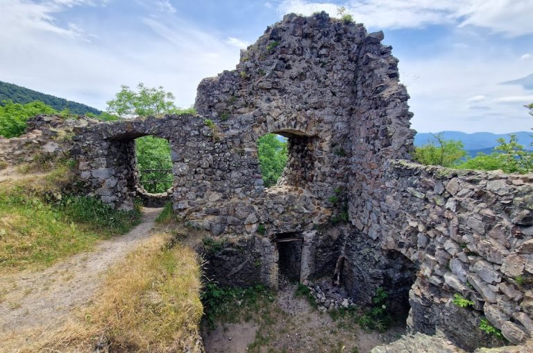
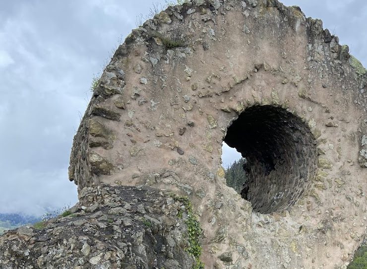
The lowest surviving section of the keep came to rest in a position resembling an eye looking into the valley. It became popularly known as the “Witch’s Eye,” and the ruins appeared in several nineteenth-century Romantic engravings. In later centuries, the ruins were repeatedly quarried, reducing the surviving fabric. The Society for the Conservation of Historic Monuments in Alsace began clearance work in 1863.
Protection and Conservation
The ruins were classified as a Monument historique on 6 December 1898 under the then German administration, and French authorities renewed the protection in 1930. The city of Thann now owns the site. Between 2006 and 2012, volunteer restoration organized through Études et Chantiers Grand Est exposed sections of walls and artillery defenses and consolidated them. Detailed surveying during the work also allowed a computer-generated three-dimensional reconstruction. A support association founded in 2013 has continued working with the city to preserve and secure the ruins.
Remains
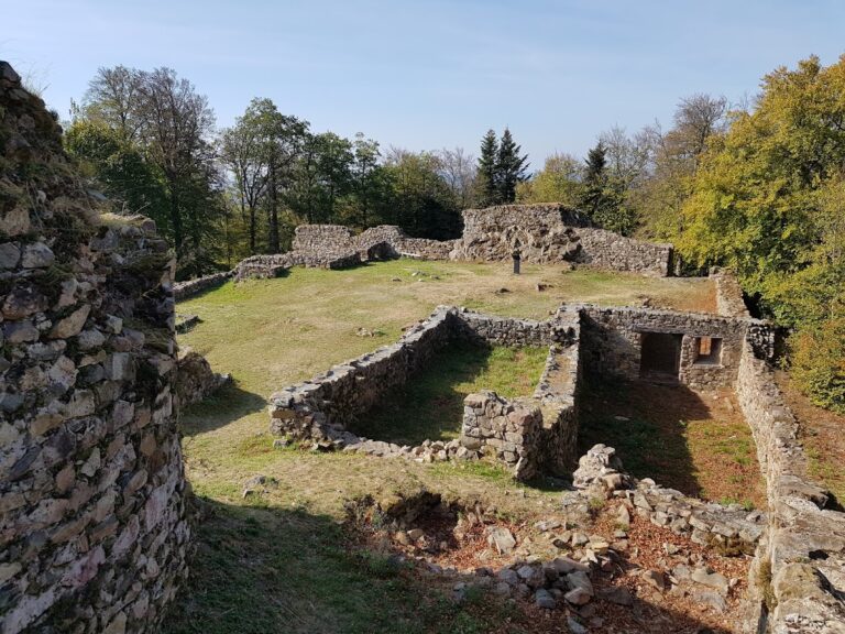
The ruins occupy the rocky summit of the Schlossberg at an elevation of 445 metres, about 100 metres above Thann and separated from the town by the Thur. The castle ground is heavily terraced, reflecting both the natural slope and rubble created by the seventeenth-century demolition. Surviving rubble masonry consists of greywacke and large pebbles from the Thur. A plan drawn in 1657 shows the fortress at its greatest documented extent, with four fortified sections arranged on three levels and separated by staggered enclosing walls.
Inner Bailey and Keep
Enclosing Walls and Early Building
The highest section was the small, rectangular inner bailey, a fortified upper courtyard. A ring wall enclosed it, and access required passage through four gates. Remains of the enclosing wall survive in the northwest and south. In the northwest wall, an intact Romanesque round-arched window survives. It indicates that an early building stood there during the foundation period and may have been the Castellan’s House, which was demolished in 1570. By 1657, a freestanding structure apparently occupied the courtyard, beneath the rubble of the keep.
Circular Keep
The inner bailey contained a powerful circular keep, the principal fortified tower of the castle. Its form resembled the keeps at Kaysersberg and Pflixburg. The tower had walls 2.5 metres thick and a diameter of 7.5 metres. A raised entrance on the southwest side faced away from the approach, while a crenellated fighting platform crowned the structure.
The 1673 explosion left an approximately four-metre-high section standing. It now lies directly southeast of the tower foundations and forms the feature known as the “Witch’s Eye.” Fallen masonry also preserves evidence of the cohesion of some late-medieval mortars. The keep’s cylindrical form, short arrow slits, and oval gun openings show how the tower was adapted for artillery as defensive methods changed.
Middle Bailey Buildings
Residential Building
South and west of the inner bailey lay the middle bailey, enclosed by its own ring wall. Its approximately oval area measured about 150 metres from east to west and about 70 metres across. It now forms a level area that slopes slightly downward toward the west.
The principal building in the middle bailey stood in its southwest section. This large, three-storey residence is represented by a cellar depression and surviving wall fragments. It may have been built around the period of Thann’s town fortifications, about 1290, and was probably the “Duke’s House” mentioned in 1473. The building replaced an earlier structure, a fragment of which retained one-metre-high sandstone bossage masonry as late as 1980.
Chapel and Southern Tower
A small round tower stood at the southern corner of the residential building and had been fitted with a bell by 1657. The new castle chapel recorded in 1619 is therefore thought to have occupied this tower or a position immediately beside it. It replaced an older chapel probably located farther west. That earlier chapel was dedicated to Saint Catherine and had lost its function after 1503.
Well Tower
The youngest part of the middle bailey was a tower projecting northward beyond the wall line. Built in 1621, it contained the castle well and formed part of the late rebuilding of the fortress.
Artillery Defenses and Outer Areas
Rondels and Zwinger
A rounded artillery fortification, or rondel, stood at the northwest corner of the middle-bailey enclosure. Its surviving architecture dates it to the late fifteenth or early sixteenth century, and a substantial section of its wall remains. A larger artillery rondel was built at the eastern corner during the same period, where an amorphous foundation wall survives.
Southeast of the middle bailey was a zwinger, an outer defensive zone between fortifications or in front of a main wall. It also dates from the fifteenth or sixteenth century. Four semicircular towers strengthened this area and allowed defenders to fire along the approach below. Slight remains of these defenses survive.
Fortified Forecourt
A fortified forecourt occupied the western end of the castle area and contained a large building. The route toward the middle bailey passed through this space and was protected by a shell tower beside the middle-bailey gate. The surviving fabric appears to be approximately contemporary with the inner and middle baileys and may also date from around 1300.
Lower Bailey and Access Defenses
The lower bailey surrounded the inner and middle baileys on the south and east. Its ring wall was topped by crenellations and survives in the southwest to a height of up to three metres. Entry was through a gate at the eastern corner. From there, the route followed the shape of the rock along its southern side to a second gate, which was flanked by a slightly higher semicircular tower.
Nearby sites