Castle of San Vicente de la Sonsierra: Navarrese Fortress on the Ebro Frontier


Site at a Glance
- Rating
- 4.6
- Popularity
- Very Low
- Country
- Spain
- Primary era
- Medieval
- Eras represented
- Bronze Age, Medieval, Early Modern, Modern
- Civilizations
- Crown of Castile, Kingdom of Navarre, Spanish
- Site type
- Military
- Remains
- Castle
On this page19 sections
History
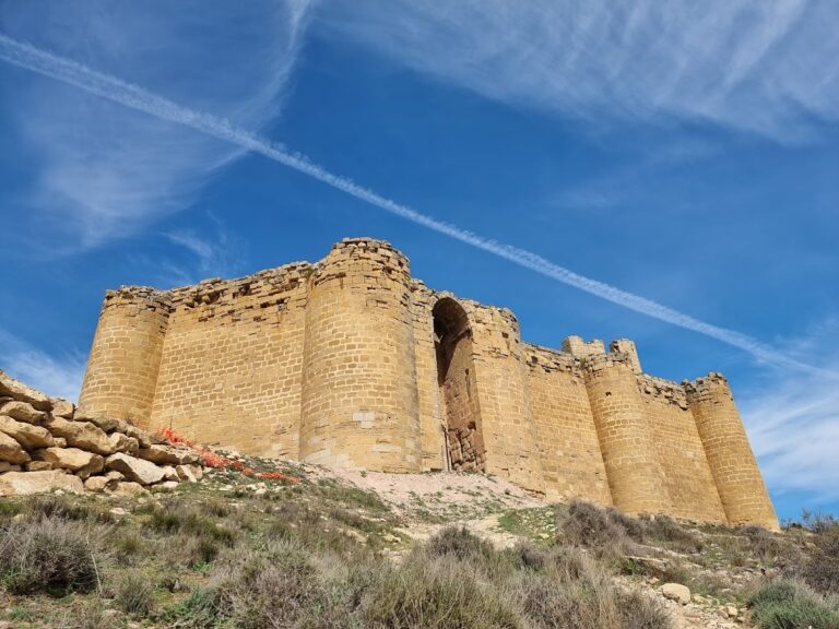
The Castle of San Vicente de la Sonsierra is a medieval Christian fortress in Spain, built by the Kingdom of Navarre in 1170 on the hill above San Vicente de la Sonsierra. It defended Navarre’s southern frontier with Castile in the Ebro valley and formed part of a fortified line between Laguardia and Labastida. Facing the Castilian Castle of Davalillo across the river, it became Navarre’s largest fortress on this frontier.
Foundation under the kings of Navarre
The hill had been occupied before the medieval fortress was built. A settlement from the end of the Bronze Age lies within the lower enclosure, while earlier occupation may have continued into the Early Iron Age. In 1170, Sancho VI of Navarre, known as Sancho the Wise, ordered the construction of the castle and appointed Ferrant Moro to direct the works and govern the new stronghold.
Two years later, Sancho VI granted a charter to San Vicente de la Sonsierra, establishing the settlement as a royal town beneath the fortification. The castle therefore served both as a military base and as the protective centre of a dependent community. In 1194, Sancho VII of Navarre, called Sancho the Strong, ordered an enlargement. The work created the upper triangular enclosure and its keep, reinforcing the fortress’s position on the Navarrese-Castilian border.
Conflict and changing ownership
The fortress was repeatedly drawn into the wars between Castile and Navarre from the thirteenth through the fifteenth centuries. Castile captured it in 1379, but Navarre recovered it in 1387. In 1367, Charles II of Navarre had already authorized the sale of building plots inside the fortified enclosure, encouraging houses for the town’s inhabitants and beginning a more intensive civil occupation of the military space.
During the fifteenth century, Henry IV of Castile took the fortress and granted it to Pedro Girón, master of the Order of Calatrava, a Castilian military-religious order, in return for his help in the capture. Girón’s son, Juan Téllez de Girón, Count of Ureña, sold the castle to the Velasco family in 1516.
From stronghold to town and religious precinct
After Navarre was incorporated into Castile in 1512, the castle ceased to function as a military stronghold and developed into a civil and religious area. Santa María la Mayor and the Hermitage of San Juan de Arriba were built within the former military enclosure. The church became the principal religious focus, while the hermitage continued an earlier connection with the castle chapel and the residents of the enclosed settlement.
A detached tower was adapted during the seventeenth century to hold a public clock and became known as the Clock Tower. Alterations to the outer wall followed in the eighteenth century. In 1814, the upper enclosure and keep were converted into a cemetery, a use that continued until 1890. The change preserved the area as a defined enclosure while giving its principal military structures a new funerary function.
Carlist Wars and decline
The Carlist Wars were nineteenth-century Spanish civil conflicts between supporters of the Carlist claim to the throne and their opponents. During the First Carlist War of 1833 to 1840, the castle regained military importance. An artillery bastion, a projecting defensive work designed to accommodate weapons, was built above the former Salas Gate. New walls with firing openings were added, and the access route and keep were altered. The fortress remained in military use during the Second Carlist War from 1872 to 1876.
Parts of the walls, the Primicia or Navarre Gate, and several houses attached to the fortifications collapsed in 1897. The gate was rebuilt in 1898 under the direction of the architect Francisco de Luis y Tomás, but the reconstruction did not follow the medieval structure’s original position or orientation. The earlier gate had stood at an angle to the approach path. Dangerous stretches of wall were also underpinned, while Salas Gate was demolished in 1935.
From the late nineteenth century, much of the fortified enclosure was abandoned and used as a rubble dump and quarry. Stone from the ruins was reused in new construction, and the residential area declined further during the nineteenth and early twentieth centuries. Santa María la Mayor and the Hermitage of San Juan remained in use, preserving the religious life of the hill while the military and residential fabric deteriorated.
Conservation and interpretation
The Main Tower was consolidated in 1982 under the architect Manuel Manzano Monís. Further work commissioned from Manzano followed in 1983, and an intervention directed by the architect Julio Sabrás Farias took place in 1989 and 1990. A broader recovery and interpretation program began in the early twenty-first century.
The Fortified Enclosure Restoration Master Plan, prepared in October 2004, combined historical research with archaeological, architectural, environmental, landscape, tourism, and legal studies. Its central principle was to consolidate surviving fabric rather than reconstruct the fortress, while ensuring that new interventions could be recognized. Archaeological excavation and conservation subsequently addressed the walls, Main Tower, Clock Tower, churches, entrances, and surrounding spaces. Major phases involved the architect Jesús Ramos Martínez and the archaeologist Pedro Álvarez Clavijo. In 2014, the municipality received the Silver Medal of the Association of Friends of the Castles of Spain for the restoration and interpretation program.
The castle and its walled enclosure are protected under Spain’s general castle-protection decree of 22 April 1949 and Law 16/1985 on Spanish Historical Heritage. Santa María la Mayor has held national-monument status since 1933. The Hermitage of San Juan de Arriba is associated with the Brotherhood of the Holy Vera Cruz of the Disciplinants, which is known from at least 1551 and maintains the penitential picaos practice of ritual self-flagellation during Holy Week. It is described as the only surviving disciplinant brotherhood in Europe to perform this practice.
Remains
The fortress occupies the highest part of the town, on a hill about 528 metres above sea level overlooking the Ebro valley. Its plan follows the rocky summit in a semicircular or kidney-shaped form. Three successive fortified areas organize the site: the outer albacar, or enclosure for associated inhabitants and settlements, the intermediate enclosure, and the upper castle. High-quality sandstone and limestone ashlar, rubble masonry, and rough cobbles appear in the walls. On the outer face of the lower wall, some bonding stones project more than 70 centimetres.
Upper castle and water supply
Main Tower
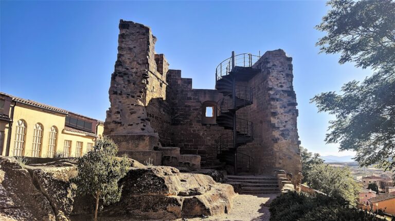
The Main Tower, or keep, stands at the summit and began as a watchtower. It formed the core of the fortress created in 1170. The rectangular structure originally contained at least three levels with timber floors, supported by stepped recesses in solid ashlar walls filled with rough stone. The lower masonry is reddened, apparently as a result of fire.
The tower retains its original entrance at mid-level and its original arrow slits, narrow openings used for observation or weapons. The present access is later and required reinforcement during conservation. The original timber floors had disappeared, and a nineteenth-century roof rested directly on the surviving walls. A nineteenth-century reconstruction introduced a new roof, floors, and an internal wooden staircase in the northeastern corner. Between 2008 and 2010, non-original openings were closed with slightly recessed rubble masonry, while the earlier entrance and arrow slits were preserved. A ground-level opening was reinforced because it lacked a lintel. Later work provided an internal route to the roof terrace, which now occupies a tower of approximately 86.25 square metres.
Upper enclosure
In the early thirteenth century, a triangular wall circuit was built around the tower, which stood at its southern vertex. The later upper enclosure has an irregular trapezoidal form. Nineteenth-century military changes added walls, small turrets, earthworks, and a bastion with firing openings. In 2012, the bastion’s openings were reconstructed from historical graphic evidence, and the southwestern wall was strengthened to prevent a collapse toward the Barbacana promenade, an outer defensive work protecting an approach.
The upper area preserves surfaces from several periods. Medieval paving made of rounded stones, lime mortar, and compacted earth belongs to the fourteenth and fifteenth centuries. Later burials, gravestones set into the ground, silos, and other occupation layers reflect changing uses of the enclosure. Five graves cut into gravel predate the castle. An inscription on the lintel of the western entrance refers to the reign of Fernando VII in 1814.
Cistern and well
Below the upper courtyard lies a cistern popularly called the “Moor’s Chamber.” It is 10.21 metres long, 2.80 metres wide, and 3.35 metres high, with a barrel vault made entirely from limestone ashlar. The cistern was collecting rainwater by the fourteenth century and helped secure supplies within the fortified summit. During the nineteenth century, it was divided into two spaces, probably for use as a prison or storage area.
An octagonal shaft beside the cistern descends 6.75 metres, although it may continue farther. Its exact function remains uncertain. Local legends describe a possible tunnel leading toward the Ebro, while its practical purpose was probably to provide a water well during drought.
Religious buildings
Santa María la Mayor
Santa María la Mayor is a Late Gothic parish church built in the sixteenth century within the former arms courtyard. Its surroundings include walls and buttresses from the late seventeenth century, together with open-sided structures called conjuratorios. These small religious buildings resemble military sentry boxes and were used for prayers intended to protect the town from storms. The doors and windows of the new structures were recorded in 1693, and the easternmost one was rebuilt in 1973.
The church roof was renewed over approximately 1,023 square metres between 2003 and 2004. Later work cleaned and repaired the ashlar and wooden elements of the choir. Missing pieces were reproduced in Chilean cherry wood, while deteriorated areas were treated with walnut. The church also preserves painted features, including a Latin inscription in black letters on a white frieze around the presbytery, geometric borders, polychrome capitals with human and animal combat scenes and faces, and a shield bearing symbols of the Passion of Christ. These paintings were cleaned, stabilized, repaired with lime mortar, and reconstructed only where their original form could be established securely.
Hermitage of San Juan de Arriba
The Hermitage of San Juan de Arriba, also called San Juan de la Cerca, was built in 1385 for Diego López de Ábalos, the castle’s castellan and governor of the town. It probably began as the castle chapel and later served as the parish church for people living inside the enclosure, until Santa María la Mayor was built in the sixteenth century.
The building is an early Gothic, single-nave church with a pointed barrel vault, a pointed triumphal arch resting on pilasters, and a rectangular chancel covered by ribbed vaults. Exterior buttresses correspond to the pilasters supporting the triumphal arch. Five arched burial recesses, or arcosolia, are set into the walls. The double-pitched roof rests on plain corbels, and a braced entrance opens in the south wall. The northern approach to the atrium was repaved over approximately 310 square metres with recovered rounded stones on a hydraulic-lime base and compacted aggregate.
Outer enclosure and entrances
Lower enclosure
The lower outer wall surrounds a large cortijo, or outer fortified enclosure, beneath whose protection houses for the town’s population were built. Rectangular flanking towers of different sizes strengthen most sides. The northwestern side relies more on the steep mountain slope, while the eastern entrance is protected on its right by a solid square tower. This outer fortification was constructed between the thirteenth and fourteenth centuries.
Archaeological excavation in the lower enclosure exposed remains of the former residential settlement, perpendicular walls, two cuttings in the rock, and layers reaching as much as 6.50 metres below the former surface. In some areas, accumulated fill was removed to approximately 7 metres. The lower southern wall had lost parts of its profile and its entire upper course; it was stabilized after internal deposits were removed. The lower enclosure also contains the prehistoric settlement from the end of the Bronze Age.
Primicia and Salas Gates
The fortress had four recorded accesses. The Primicia or Navarre Gate stood on the south, Salas Gate on the north, and two western entrances led toward the church and the former cemetery. The Primicia Gate was rebuilt in the late nineteenth century and restored in 2008 and 2009. Excavation revealed the position and orientation of the medieval gate, which stood perpendicular to the wall rather than along the line of the later reconstruction.
Conservation consolidated the surrounding walls and installed a controlled closure at the entrance. Excavation also exposed a hollow flanking tower, or “cube,” unlike the other towers and apparently designed to contain the mechanism for opening and closing the gate. Salas Gate was demolished in 1935, although parts of its former structure survive. A nineteenth-century artillery bastion was built above its position.
Western access and Clock Tower
The route from the town toward Santa María la Mayor was added after the original wall had been built. Its wooden lintel was replaced in stages in 2009, followed by the installation of a new door. Between 2008 and 2010, the northern wall was stabilized, while the eastern lower wall was freed from sediment on both faces in 2016. This work exposed approximately 45.50 metres of wall and covered about 1,050 square metres.
The Clock Tower stands between the upper enclosure and the open area containing Santa María la Mayor and San Juan de Arriba. It is a detached, square-plan tower outside the castle wall, built in the seventeenth century over an earlier tower. Its original public-clock mechanism survives, and the interior now contains a museum of tower clocks.
Paths, walls, and restored surfaces
Several access and processional surfaces preserve the relationship between the fortified areas and the religious buildings. A 590-square-metre approach from Fortaleza Street was paved with rounded stones, while a deteriorated cobbled surface of 455 square metres was dismantled and relaid. Terraces beside Santa María la Mayor were restored over areas of 327 and 243 square metres using rounded-stone paving, lime-based bedding, drainage, and reconstructed ornamental patterns.
A further 443-square-metre area on the western side of the hill received similar paving together with rainwater collection, lighting, electricity, furniture, and planting. The staircase of Santa María la Mayor was restored in 2011 with cleaned and reshaped sandstone steps, and its right jamb was replaced. Together with the stabilized walls, towers, waterworks, and excavated occupation layers, these surfaces preserve the physical record of a fortress that became a town and religious precinct without losing the outline of its medieval defensive structure.