Castle Alt-Wildon: A Ruined Hill Castle in Austria


Site at a Glance
- Rating
- 4.6
- Popularity
- Very Low
- Country
- Austria
- Primary era
- Medieval
- External website
- Open
- Eras represented
- Medieval, Early Modern
- Civilizations
- Duchy of Styria, Holy Roman Empire
- Site type
- Military
- Remains
- Castle
On this page15 sections
History
Castle Alt-Wildon is a ruined hill castle in Austria, on Wildon Castle Hill in southern Wildon. The Lords of Wildon built it on sovereign land in the mid-twelfth century, probably around 1170, as part of a group of four fortifications beside the Mur River and the old imperial road. Its position guarded a strategically important area near one of the few crossings of the river.
Early settlement and medieval beginnings
Wildon Castle Hill had already been settled long before the medieval castle was built. Archaeological traces date to about 4600 BC and include material from the Middle Neolithic and the Urnfield period, a later Bronze Age era named for the burial of cremated remains in urns. In the medieval period, the hill overlooked the imperial road that passed through Wildon.
The Hengistburg, an early medieval fortified site associated with the region, was first mentioned in 1053. Its exact location remains uncertain, although it may also have stood on Wildon Castle Hill. Pottery from the hill demonstrates the presence of a fortification from the Carolingian-Ottonian period, the broad era shaped by the Carolingian rulers and the later Ottonian dynasty between the eighth and eleventh centuries. The archaeologist Diether Kramer used these finds to support the proposed location of the Hengistburg on the hill.
The Lords of Wildon probably commissioned Castle Alt-Wildon around 1170. Hartnid I, an early member of the family, is a likely patron. A document from 1172 still described him as being of Riegersburg, while documents from 1173 and 1174 identified him as being of Wildon. This change in title reflects the family’s association with the castle and its territory during the period when the new stronghold was being established.
Later medieval transformation
The date when Alt-Wildon ceased to function as a castle is unknown. A “new castle,” identified as Neu-Wildon, was first mentioned in 1260, but Alt-Wildon probably remained in use for some time afterward. Its residential tower dates from around 1400, showing that activity continued at the site well after Neu-Wildon had appeared in the written record.
The historian Robert Baravalle proposed that the Lords of Wildon surrendered Alt-Wildon to Duke Albert I after their failed revolt in 1294. Albert I was a Habsburg ruler who held the title of Duke of Austria and later became King of Germany. The proposed transfer offers one explanation for the castle’s changing status, although the exact sequence of its later use and abandonment is not known.
Ruin, excavation, and conservation
Georg Matthäus Vischer depicted Castle Alt-Wildon as a ruin in a copper engraving made in 1681. Vischer was a seventeenth-century Austrian cartographer and engraver known for detailed views and maps of Austrian territories. The image provides evidence that the castle had already reached a ruined state by the late seventeenth century.
Between 1860 and 1880, Joseph Freiherr von Neupauer, then the owner of Schwarzenegg Castle, established several quarries on Castle Hill. One quarry lay directly south of the Alt-Wildon site. The steep slopes around the ruin may therefore reflect both natural terrain and nineteenth-century stone extraction, although the extent of that alteration remains uncertain.
From 1985 to 1994, the Joanneum Provincial Museum carried out excavations around the residential tower and the area probably associated with tournaments under Diether Kramer’s direction. The work cleared debris, removed trees, and repaired all surviving masonry at Alt-Wildon. Excavation trenches were left visible in the terrain and were only partly published in preliminary reports. Later excavations around the chapel and tower, in 2015 and 2017, revealed previously undocumented masonry belonging to several construction phases.
Since 2004, the Kulturpark Hengist association has managed Castle Hill. The foundation of the residential tower was repaired in 2014 and 2015, and the remaining excavation trenches in the Alt-Wildon area were subsequently filled. The hill and the ruin remain privately owned.
Remains
Castle Alt-Wildon occupies a westward-projecting spur of the summit plateau of Wildon Castle Hill. The plateau is about 300 metres long and 80 metres wide, remains connected to the main hill on the east, and falls steeply toward the north, south, and west, in places over exposed rock. Its western end broadens into a small plateau before the drop, while the approach runs from the east across the connection to the hinterland.
Approach and defensive boundaries
Entrance route and surrounding fortifications
The present forest track follows the former pointed ditch before turning west and also provides access to Neu-Wildon, whose ruin lies about 150 metres east of Alt-Wildon. The track ends in the area identified as a possible tournament ground. At about half the height of Castle Hill, the route formerly passed the two additional fortifications known as Ful and Hengst, of which remains survive.
Curtain wall and retaining walls
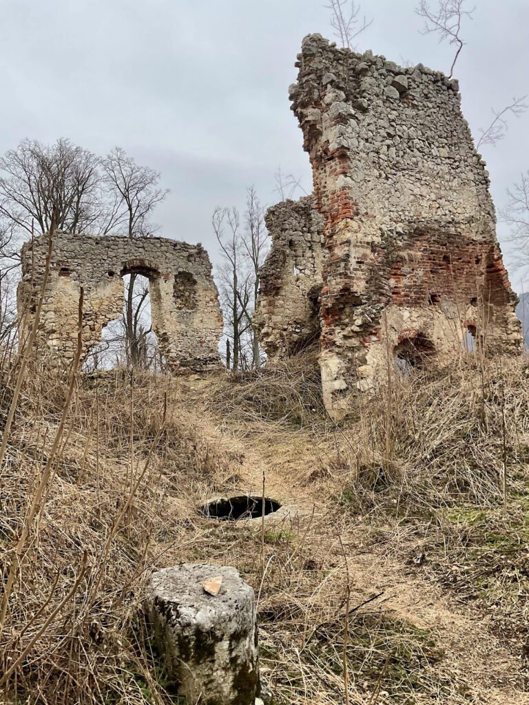
A curtain wall, an enclosing defensive wall linking fortified points, originally surrounded the northern, northwestern, and western sides of the castle plateau. Sections of its ashlar-built retaining wall survive. A narrow slit loophole, used for observation or firing, remains in the northern masonry, and traces of a doorway can be seen in the western wall.
Retaining walls also support the southern and southwestern sides of the castle area. The southern section directly below the chapel consists of regularly coursed small ashlar blocks resembling the masonry around the residential tower. It probably belongs to the castle’s twelfth-century construction. The rounded southwestern section uses larger ashlar blocks and was probably strengthened by a facing wall during the late twelfth or thirteenth century.
Possible tournament area
A short distance northeast of the Römerturm is a flat, elongated rectangular area enclosed by wall remains. Its original function is unknown, although it has sometimes been interpreted as a tournament ground. Excavations in this area formed part of the archaeological work conducted around the castle between 1985 and 1994.
Chapel and residential tower
Chapel
A ruined chapel stands on the small western plateau, supported along its southern and southwestern sides by the retaining wall. It is identified variously as the Anna Chapel or the Johannes Chapel. The freestanding building dates from the early modern period and originally had a barrel vault, a continuous curved ceiling, together with Gothic buttresses. A coat of arms dated 1520 and associated with Ulrich von Leysser remains inside the ruin.
Römerturm
The Römerturm, also called the Heidenturm or Pfeilturm, is the castle’s residential tower and its best-preserved component. It stands on a rock at the highest point of the castle area. The square tower retains three storeys and is built of irregular, roughly coursed rubble masonry incorporating small ashlar blocks. Dressed corner stones define its edges, while the masonry and the forms of its door and window surrounds place its construction around 1400.
A small earthen footbridge or walkway survives on the ground floor. The southern side of the first upper storey contains a slit window. On the northern side of the second upper storey, a Gothic rectangular window remains beside what was probably a doorway leading to a balcony. The balcony’s corbels, projecting stones that supported the structure, are still visible. The eastern side of the same storey retains another corbel and a rectangular window.
Earlier masonry and water supply
Twelfth-century buildings
Excavations west and north of the residential tower exposed masonry from the twelfth century and the remains of a hall building. The hall had originally been incorporated into the northern and eastern stretches of the curtain wall, linking the principal building area with the castle’s enclosing defenses.
Cistern
The same excavations revealed a cistern, a structure used to collect or store water. Its position near the residential tower and the excavated masonry forms part of the evidence for the organization of the medieval castle interior.