Burgruine Schauenforst: A Medieval Hilltop Castle in Germany


Site at a Glance
- Rating
- 4.6
- Popularity
- Low
- Country
- Germany
- Primary era
- Medieval
- Eras represented
- Medieval
- Civilizations
- Holy Roman Empire
- Site type
- Military
- Remains
- Castle
On this page9 sections
History
Burgruine Schauenforst is the ruin of a medieval hilltop castle in Germany, near Rödelwitz in what is now Uhlstädt-Kirchhasel, Thuringia. The fortification was built no earlier than the thirteenth century and occupied a strategic position between Orlamünde and Rudolstadt. Its elevated location made it both a fortified residence and a defensive complex.
Origins and the Lords of Schauenforst
A tradition holds that Landgrave Ludwig IV of Thuringia built the castle in 1222 or 1223 during a feud with Count Hermann II of Orlamünde. This interpretation remains disputed. Archaeological finds place the castle no earlier than the thirteenth century, while a general agreement reached in 1908 held that it already existed in 1223. The castle may have replaced an older fortification on nearby Eichberg, offering a more comfortable residence and a stronger military position.
Schauenforst belonged to Count Hermann of Orlamünde and became a strategic center between the territories of Orlamünde and Rudolstadt. The first written references to the Lords of Schauenforst date from 1281. These lords belonged to the Meldingen family and held their position as feudal dependants of the Counts of Orlamünde. They were probably former residents of the castle by that time. Heinrich V of Orlamünde was living at Schauenforst in 1338.
War, changing ownership, and decline
During the Thuringian Counts’ War, a conflict that reshaped the position of several ruling counts in Thuringia, Heinrich V lost his status as a prince and became a vassal of Landgrave Frederick II. Schauenforst remained his only fortress, and he lived there until his death in 1357. It is uncertain whether the castle was destroyed during the war.
Several owners held Schauenforst until the middle of the fifteenth century. The castle may have suffered destruction during the Saxon Fratricidal War, a conflict between members of the Saxon ruling family. The territory associated with Schauenforst contracted during this period. At the end of the fifteenth century, the House of Reuss of Plauen, a ruling noble dynasty in central Germany, acquired the castle and Rödelwitz.
By the end of the sixteenth century, Schauenforst was already in poor condition. It was first incorporated into the Lordship of Oberkranichfeld and later pledged again, while ownership changed repeatedly. The complex gradually deteriorated until it became uninhabitable. Later owners focused mainly on the associated estates, especially the surrounding vineyards, rather than on maintaining the castle. In 1663, Schauenforst passed from Schwarzburg ownership to Saxe-Gotha and remained there for an extended period.
Preservation and later territorial changes
After a territorial division in 1826, Schauenforst and its ruins became part of the Duchy of Saxe-Meiningen. Treasure hunters caused damage during the eighteenth and nineteenth centuries. In 1835, State Chamber Councillor Friedrich Gustav Vogt of Blankenhain acquired the castle and commissioned its first preservation work. Duke Ernst I of Saxe-Altenburg bought the entire area in February 1881 for the ducal domain fideicommissum, an inalienable hereditary estate held by a ruling house. Major repairs to the curtain wall and tower followed in 1913.
Remains
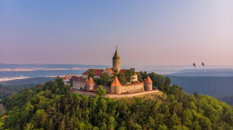
Schauenforst is a multi-part hilltop fortification with an unusually elongated plan. The ridge of the Schlossberg measures about 150 metres in length but only 5 to 35 metres in width. The summit was most easily reached from the north, where two walled defensive positions on neighboring hills and a series of ditches protected the approach. Some of these earthworks remain partly visible.
Defenses and castle wards
Outer ward
A ring ditch encircled both the outer and main wards, with especially broad and deep sections on the eastern side. The outer ward occupied the northwest part of the complex and was partly defended by two lines of walls. A defended outer enclosure separated it from the main ward, and a drawbridge controlled the connection. The outer ward probably functioned chiefly as an agricultural and service yard.
Main ward
A large round tower beside the defended enclosure dominated the main ward. It is the best-preserved part of the castle and remains visible from a considerable distance. On the southeast side stood the principal residential and representative building, with a basement, together with an ancillary building and the tower. Sections of the massive curtain wall survive between these structures in isolated stretches.
Water supply and surviving structures
The main-ward courtyard contains a collapsed cistern. A pipe supplying spring water probably served the castle during peacetime, adding a water system to the defensive and residential arrangements on the narrow ridge.
Nearby sites