Burg Nieder-Modau: A Medieval Hilltop Castle in Germany


Site at a Glance
- Rating
- 5
- Popularity
- Very Low
- Country
- Germany
- Primary era
- Medieval
- Eras represented
- Medieval
- Civilizations
- Holy Roman Empire
- Site type
- Military
- Remains
- Castle
On this page9 sections
History
Origins and Katzenelnbogen Rule
Burg Nieder-Modau was a hilltop castle in Germany, north of Nieder-Modau and south of Ober-Ramstadt in the Vorderer Odenwald, the western lower-hill region of the Odenwald uplands. Its builders and exact date are uncertain. Proposed dates range from the eighth or eleventh century to around 1200, when the Lords of Crumbach or local nobles may have established it.
The Modau Valley belonged to the Upper County of Katzenelnbogen, a territory governed by the medieval Counts of Katzenelnbogen. This political setting suggests that any castle in the valley would have been built on behalf of those territorial rulers. A record from 1247 names Gerhardus de Muda as a castleman at Auerberg, a nearby Katzenelnbogen castle. The entry does not show that he lived at Burg Nieder-Modau or took part in its construction, but it places a person connected with the Modau area within the Katzenelnbogen military system.
Conflict, Destruction, and Abandonment
The castle was allegedly destroyed between 1379 and 1382 during conflicts between the Lion League, a regional political and military association, and the city of Frankfurt. The connection between the destruction and that conflict cannot be established securely. Werner Kalb von Reinheim, a vassal of the Counts of Katzenelnbogen, is traditionally regarded as the castle’s last lord and was remembered as a robber knight.
Large numbers of projectile stones around the Schlossberg indicate that attackers and defenders used trebuchets, siege engines that hurled heavy stones. After the castle fell from use, its ruins supplied building material for centuries. By 1576, local memory preserved the site only in the field name “Old Castle,” showing that the original history of the stronghold had largely faded from view.
Early Investigation and Later Landscape Change
Excavations in 1827 exposed parts of the ring-wall foundations, although stones from the internal building foundations were removed for road construction. In 1830, chief forester Friedrich Heyer ordered the remaining wall fragments to be cleared, the area levelled, and the site planted with black pines. Georg Wilhelm Justin Wagner, a nineteenth-century geometer and antiquarian, measured and described the remains in 1835, when foundations were still visible.
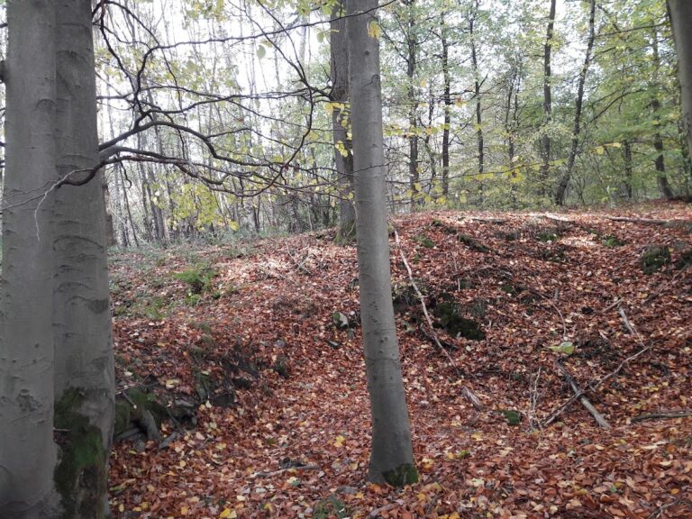
The black pines were felled in 1953 and 1954 and replaced with linden trees. Despite these changes and the long use of the ruins as a quarry, the castle ramparts and southern entrance remain clearly discernible in the terrain.
Remains
Hilltop Enclosure and Defences
The castle occupied the conical Schlossberg at approximately 280 metres above sea level. The Modau River curved around the hill from the southwest to the north along its steep western side, while the Rohrbach stream followed the gentler eastern slope before joining the Modau to the north. This position gave the stronghold a naturally defended setting, reinforced by an elliptical plateau whose long axis ran from southwest to northeast.
A substantial ring wall enclosed the plateau, with a deep ditch outside it. The ditch had an estimated circumference of about 265 metres, and the enclosed area covered slightly more than 5,000 square metres. Wagner measured the plateau at roughly 284 feet along its long axis and 184 feet across its shorter axis. He found sections of the thick ring wall still standing several feet above ground level, while the ditch reached about 20 feet in depth beside the wall.
Entrances, Ramparts, and Ditch Features
The southern approach crossed the ditch on a raised access route leading to the castle entrance. The southern entrance and the ramparts remain visible. On the northeastern side, a shallow stretch of ditch survives together with large stones incorporated into its outer wall.
Steeper ditches and channels on the eastern side of the hill may preserve traces of an earlier quarry. Basalt blocks scattered across the plateau probably came from the former castle buildings. A partly destroyed trebuchet stone, made of a lighter-coloured granite, also remains on the site and relates to the siege activity associated with the stronghold.
Buildings and Archaeological Finds
Foundations show that several buildings once occupied the enclosure. A circular foundation in a central hollow has been interpreted as the site of the bergfried, the principal fortified tower used for defence, observation, and refuge rather than as the lord’s ordinary residence. Burnt clay, hollow bricks, and dressed sandstone blocks point to timber-framed buildings standing on masonry foundations.
Charred beams and extensive fire traces across the foundations preserve physical evidence of a destructive blaze. Other finds include spearheads and arrowheads, along with animal bones from fallow deer, roe deer, pigs, hares, and small birds. Together, these remains indicate that the medieval occupants enjoyed a comparatively rich diet.
Underground Passage and Old Castle Mill
An entrance to an underground passage was recorded on the castle site in the direction of the so-called Old Castle Mill. The mill was probably established to supply the castle, although its first documentary mention dates to 1486. Its later record therefore provides a connection with the former stronghold after the castle itself had disappeared from regular historical memory.
Nearby sites