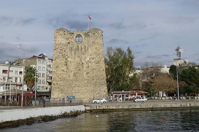
Boyabat Castle: A Historic Fortress Overlooking the Gökırmak Valley


Site at a Glance
- Rating
- 4.4
- Popularity
- Medium
- Country
- Turkey
- Primary era
- Early Modern
- Eras represented
- Classical, Medieval, Early Modern
- Civilizations
- Byzantine, Ottoman, Roman
- Site type
- Military
- Remains
- Castle
On this page6 sections
History
Boyabat Castle is a historic fortress in Turkey, traditionally attributed to the Paphlagonians and dated to around the 7th century BC. The Paphlagonians were an ancient people associated with northern Anatolia along the southern Black Sea coast. Its exact construction date remains unknown because the castle has no inscription. The site overlooks the Gökırmak Valley, a natural east–west corridor, and may have helped protect movement and trade through the region.
Early and Medieval Phases
The wider area passed through the influence or rule of several powers, including the Kaskians, Hittites, Paphlagonians, Persians, Lydians, and the Kingdom of Pontus. Roman and Early Byzantine remains within the castle reflect later phases of occupation, while the fortress was reconstructed under Roman and Byzantine rule. The precise relationship between the castle and the area’s possible Bronze Age history remains uncertain.
After the expansion of Turkish powers into Anatolia, the region came under Danishmend, Seljuq, Pervaneoğulları, Jandarid, and Ottoman control. The Danishmends were a Turkish ruling dynasty that held parts of Anatolia after the eleventh-century expansion of the Seljuq Sultanate of Rum. A few decades after the Battle of Manzikert in 1071, Gazi Gümüshtigin, the dynasty’s second leader, captured the area. The Pervaneoğulları were another medieval Turkish dynasty in northern Anatolia, while the Jandarids ruled an Anatolian principality.
Ottoman Form and Later Status
Boyabat Castle acquired its present form during the Ottoman period, following earlier Roman and Byzantine reconstruction phases. Its position may have supported caravans traveling between Durağan, Hanönü, and Taşköprü along the Gökırmak Valley. The possible connection with the Silk Road, a network of long-distance routes linking East Asia, Central Asia, the Middle East, and Europe, remains an interpretation rather than a certainty. The castle probably ceased to be in serious use around AD 1300.
The castle was registered as an immovable cultural and natural property by a decision dated 23 October 1987. It is now used as a museum and is owned by Boyabat Municipality.
Remains
Rocky Setting and Fortress Position
The castle stands at an elevation of 135 metres on the southern of two opposing steep rocky hills in the Gökırmak Valley. The Kazdere, also called Gazidere, a tributary of the Gökırmak, has cut the rock beneath the castle into steep vertical walls. From this elevated position, the fortress overlooks the valley and its natural east–west route, a setting that helped explain its possible role in protecting travel through the corridor.
Subterranean Features
A window in the rock face on the castle side provides light to tunnels descending beneath the fortress. These passages may have served as a water-supply route and as a means of safe movement during sieges. Beneath the castle lies a large underground city thought to extend under Boyabat. It contains Roman and Byzantine traces and was described as newly discovered in connection with the castle.