Area Archeologica di Nervia: The Roman City of Albintimilium in Italy

Site at a Glance
- Rating
- 4.3
- Popularity
- Low
- Country
- Italy
- Primary era
- Classical
- External website
- Open
- Eras represented
- Iron Age, Classical, Medieval
- Civilizations
- Byzantine, Roman
- Site type
- City
On this page22 sections
History
The Area Archeologica di Nervia in Ventimiglia, Italy, preserves the remains of Albintimilium, a city founded through the interaction of the ancient Ligurians and Rome from the 2nd century BC. It stood near the boundary with Gaul, in a natural channel between the Roja River and the Nervia stream, and became a municipium in 89 BC after receiving Latin rights, a civic status within the Roman system below full citizenship that could lead to it. Albintimilium was one of the principal settlements of the ancient Ligurians and later served as an important Roman urban center on the route through Liguria toward Transalpine Gaul.
The Intemelii and the Roman city
During the Iron Age, the site was the center of the Intemelii, an ancient Ligurian people. A Roman settlement developed beside the Ligurian oppidum, or fortified settlement, during the 2nd century BC. Together with Albium Ingaunum at modern Albenga, Albintimilium formed one of the principal settlements of ancient Liguria. The extent of its territory remains uncertain, although Strabo described the city as extending along the coast from Monaco to Sanremo and into the hinterland.
The city was included on the Peutinger Table, a medieval copy of an ancient Roman route map, and the Via Julia Augusta passed through it. This road connected Liguria with Transalpine Gaul. The Roman settlement occupied a strategic position between the coast and inland routes, while its urban center developed within the channel formed by the Roja and Nervia waterways.
Late occupation and abandonment
Albintimilium remained inhabited at least until the 7th century AD. After that period, the center of settlement shifted inland toward the hill of modern Ventimiglia. The ancient ruins were later covered by a large sand dune formed by winds on the beach near the mouth of the Nervia. This burial beneath sand helped preserve parts of the settlement until modern construction brought them back to light.
The rediscovery of Roman Albintimilium followed the Treaty of Turin of 1860 and the removal of sand needed for the international railway station and modern Ventimiglia. Excavation began in 1865 under the archaeologist and historian Girolamo Rossi. Weak archaeological legislation allowed clandestine digging, especially in the necropolis, and much of the funerary equipment entered foreign museums and private collections. Only a small portion was preserved for the developing local museum and Villa Hanbury.
Excavation and interpretation
Rossi uncovered part of the theatre in 1877 and the baths in 1900. He brought together the results of his work in I Liguri Intemeli, published in 1908. After his death, systematic excavations took place from 1915 to 1918 under Pietro Barocelli and the Superintendency of Antiquities of Piedmont and Liguria. These campaigns exposed much of the theatre, sections of the city walls, the northern housing blocks, and 145 necropolis tombs. The tomb discoveries were divided among the museums of Ventimiglia, Genoa, and Turin.
After a period of inactivity, excavation resumed under Nino Lamboglia from 1938 to 1976, with interruptions during the war years. Lamboglia reconstructed the history of the Roman municipium and developed methods of stratigraphic excavation and the study of Roman pottery through work at the site. The archaeological area opened to the public in 1980, when the Antiquarium was renovated by the Ministry for Cultural Heritage and Cultural Activities as an exhibition and educational center. The building had originally been a girls’ college and nursery, was partly destroyed during the Second World War, and later served as an excavation depot and laboratory until the 1980s.
Since December 2015 the Antiquarium has been managed by the Museum Pole of Liguria, which became the Regional Museums Directorate in 2019. The archaeological area is a state site administered by the Regional Museums Directorate of Liguria. Its theatre, baths, walls, streets, houses, and burial areas preserve the principal public and urban components of Albintimilium.
Remains
The excavated city occupied a slightly trapezoidal area measuring about 400 by 600 meters. Its Roman plan followed a rectilinear castrum grid, organized around main streets running broadly north-south and east-west. Two cardines and three decumani have been identified, together with remains of public buildings, housing blocks, private houses, gates, walls, roads, and necropoleis. Superimposed structures and paving levels preserve changes made over several centuries of urban use.
Streets and city boundaries
Decumanus maximus
Discovered in 1950, the decumanus maximus separated the upper Ligurian-Roman quarters from the lower quarters of the purely Roman settlement and continued toward the Porta di Provenza. The road was 2.95 meters wide and retained two well-preserved sidewalks, or crepidines. Municipal maintenance ended around the 5th century AD, after which 17 layers of new surfacing accumulated above the original pavement.
Three paving levels can be distinguished. The lower surface was carefully constructed over the first eight raising layers. An intermediate surface was partly destroyed and was associated in places with Byzantine structures and tombs aligned along the road. The upper surface, 1.65 meters thick, was made from La Turbie stone. During the Early Middle Ages, a low wall was built lengthwise across this upper surface, bringing the road’s role as the principal route to an end.
Other roads
The smaller decumanus B, excavated during campaigns from 1930 to 1940, lies farther south. It is 3.80 meters wide, has no sidewalks, and marks the boundary of the first Roman settlement. Successive building phases are visible in its layers. During the 2nd century AD it was substantially narrowed and appears to have been cut off to the east when an insula, or urban housing block, was built.
Decumanus A was identified as the Via Julia Augusta, described as the only carriage road of the Roman period in western Liguria. Cardines A and B crossed the decumani at right angles. Cardo A originally linked the decumanus maximus with the sea, but houses later bordered it during the imperial period and its public function ended. Cardo B was probably a secondary pedestrian street. Its eastern side had successive beaten-earth surfaces, while a broad depression along the western side channelled water. The street lost its function and was greatly narrowed during the Byzantine period.
The cardo maximus probably began at the southern gate, the Porta Marina, and the forum was probably located where it met the decumanus maximus. Beyond the western gate, the main east-west road became the Via dei Sepolcri and crossed the extensive necropolis. Burial areas occupied western, northern, and eastern sectors along the roads.
Walls and gates
The city walls were constructed from small pebbles bonded with lime and were approximately 2.30 meters thick. Three sides are securely known. The southern wall faced the sea and contained the Porta Marina, discovered in 1885. Its round-arched opening was 1.70 meters wide and received the cardo maximus. The western side was partly destroyed when the theatre was built, but it preserves a defensive structure dating from the Republican period.
The northern wall incorporated the Porta Praetoria, also called the Porta di Provenza, behind the theatre. The gate had two offset circular towers, an access stairway, an internal arms court, and three openings. The central opening was the only one wide enough for vehicles, and another stairway led to the upper wall. Its defensive function continued until the middle of the imperial period.
The eastern wall, which probably connected the port with the hill, remains uncertain. Two wall segments may have formed a projecting defense for the port, whose shoreline was then much closer to the fortifications than it is today. The circuit dates from the 1st century BC, probably between 80 and 60 BC. A possible connection with Julius Caesar’s activities during the conquest of Gaul remains unconfirmed.
Theatre and necropolis
Roman theatre
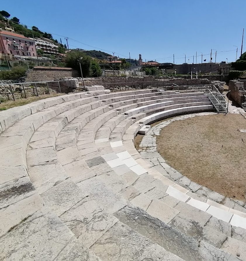
The theatre stands at the northwestern edge of the urban area, near the necropolis. It was built between the end of the 2nd and the beginning of the 3rd century AD, requiring the demolition of earlier structures that included part of the western wall and part of the southern tower of the Porta di Provenza. Rossi exposed its upper remains in 1877. Barocelli uncovered about two-thirds of the building, and Lamboglia completed the excavation during later campaigns.
Burial grounds
The necropolis contains mainly burials from the first two centuries of the Roman Empire. Earlier graves used cremation and contained rich furnishings dating approximately from AD 1 to 160. The sand preserved many of these burials. Later graves used inhumation and had poorer grave goods. Some burials were enclosed within family precincts, although few were truly monumental.
Barocelli’s excavated tombs were numbered from 1 to 146 and produced dozens of inscriptions and funerary stelae bearing the names of prominent families from Albintimilium. After 1938, Lamboglia identified tombs numbered 148 to 185 in the theatre area and along the decumanus maximus.
Housing blocks and private houses
The insulae had rectangular plans measuring about 25.90 by 9.60 meters, equivalent to 84 by 32 Roman feet. Their arrangement reflects Republican urban planning, while the surviving walls were built and rebuilt using different techniques. Seven insulae have been excavated. Additional fragments north of the decumanus maximus follow the slope of the hill and cannot be assigned to a precise sequence.
Insulae I to IV
Insula I was built during the imperial period in the area of the modern hospital, between Cardo A and Decumani A and B. Renovations in the 2nd and 3rd centuries AD interrupted both decumani and turned Insula II into an internal courtyard. Insula II contains a masonry basin that supplied a round spouting fountain made from regularly cut stone blocks finished with lime mortar. A smaller basin beside it served as a watering trough.
Insula III, found in 1951 and 1952 east of Decumanus B, incorporated dwellings built over older foundations. Red plaster and a burned wooden ceiling survive among its remains. Insula IV lies west of Cardo B, but its surviving fabric does not permit reconstruction of its plan or the sequence of its renovation phases.
Cavalcavia domus
Insula V contains the Cavalcavia domus, a private single-family house. Excavation reached its oldest level, while the most visible part belongs to a reconstruction of the 3rd century AD. Its main facade faced the decumanus maximus. A central fauces, or entrance passage, stood between two tabernae, or shops. The passage had a La Turbie stone floor and led through a three-leaved doorway into a square atrium with four columns.
The bases of those columns surrounded the central impluvium, a shallow basin designed to collect rainwater from the roof, although the feature may instead have been a fountain. The tablinum, a reception room separating the front and rear parts of the house, stood opposite the entrance. A room to the right of the atrium probably served as a triclinium, or dining room, while a stairway on the left led to one or more upper floors.
Domus Libanore
The partially preserved Domus Libanore was discovered in 1916 during construction of a railway gatehouse. It contained a Roman floor mosaic with geometric motifs and three nearby rooms. The largest held the polychrome work later called the Libanore Mosaic. The house probably dates from the second half of the 1st century AD, and its plan follows the form of an Augustan domus.
The mosaic is composed mainly of medium-sized black and white marble tesserae, with some red pieces. Two nearly square zones are separated by geometric motifs and enclosed by a band of plant decoration. Their designs include semicircles and quarter-circles containing tritons, birds, female masks, and gladiator cupids. An ibis and the head of Medusa occupy the central images. The perimeter of the house also received mosaic paving during a later renovation.
Insula VI lies south of Decumanus B and interrupts Cardo A. Insula VII lies south of the same road between Cardines B and C, and its remains suggest another domus.
Bath complex
The baths were built toward the end of the 1st century AD in the western quarters, south of the theatre and beside the western insulae. They replaced an Augustan-period insula. Their final renovation belongs to the reign of Diocletian, the Roman emperor from AD 284 to 305, when existing buildings with earlier functions were adapted. The complex was destroyed immediately after the barbarian invasions of the early 5th century AD. It provided public bathing facilities for free men and women from different social classes, who used them separately, although the archaeological remains do not establish a clear internal division between male and female areas.
Heated rooms
The excavated complex appears to have contained eight large rooms. Two praefurnia, or furnace rooms, held the wood fires that produced hot air for the hypocausts, systems that circulated heated air beneath floors and sometimes through wall channels. The furnaces were enclosed by heat-resistant sandstone blocks, reached from above by masonry stairs, and included spaces for firewood. Each also had a raised level that probably served as a passage or a warm-water pool.
The furnaces connected directly with two hypocausts through a double brick conduit with a low arched passage for hot air. Room I has no surviving basin or seating to confirm a hot-water function, so it is cautiously interpreted as a laconicum, or sauna-like heated room. Its thickened corners supported a vault, and a recess in the western wall may have held furniture, a seat, a basin, or a window opening toward a garden. Small round or square pillars supported a thick-brick floor finished with thin marble slabs.
Room II is identified as a calidarium, or hot room, because its northern side retains a double masonry seat with a backrest faced with thin marble slabs. Its hypocaust has a square brick floor supported on small pillars like those in Room I. The plastered walls were decorated with mortar pilasters and lined with rectangular tubes connected with the heating system. A masonry cornice with plant motifs ran between the walls and the ceiling or vault.
Cold-water rooms and mosaics
The functions of Rooms VI and VIII remain difficult to establish. They may have been passageways, changing rooms, or massage rooms. Farther north, opposite the modern hospital, two rooms were probably frigidaria, or cold-water pools, with another room serving their hypocaust. They occupied different levels and ended to the east at a very thick wall, of which only the foundations survive. This wall probably bordered the baths along the cardo maximus. Similar construction indicates that the rooms formed part of one large complex whose principal facade faced the forum.
One frigidarium retains an almost intact masonry and brick seat along its southern wall. Both pools had mosaic floors. The Mosaic of Arion in one pool is severely damaged and was cut by construction of the former Santo Spirito hospital. It retains much of a geometric frieze and a central scene of a figure riding a dolphin, accompanied by fish, the sun, stars, and other decorations. Medium and large black and white tesserae form the composition.
The mosaic in the northern pool lies about 96 centimeters below the other. Its design contains 32 panels filled with plant motifs, including crosses, rosettes, and simple or lance-shaped leaves. A multiple border frames the composition, which is made from small black and white tesserae.
Port area and Antiquarium
Possible port zone
A projecting section of wall on the Nervia coast suggests the former location of the port, although the identification is not certain. A polychrome geometric mosaic showing the four seasons as human figures was excavated on the southern side in 1852. It belonged to a building that cannot securely be connected with port activity. The mosaic was destroyed the day after its discovery, leaving a panel with the bust of one season, now displayed in the State Antiquarium of Nervia.
Antiquarium
The Antiquarium stands at the center of the archaeological area. Its exhibition uses scale reproductions to explain the Porta di Provenza, theatre, baths, necropolis, and residential quarters. Cases contain surviving fragments of interior decoration made from Asian marbles, polychrome plaster, and stucco, together with cosmetics-related objects and vessels associated with food. These materials add evidence for aspects of daily life in Albintimilium, while the excavated theatre and baths remain visible in situ outside the museum.