Alba-la-Romaine Archaeological Site and Museum: The Roman Capital of the Helvii


Site at a Glance
- Rating
- 4.2
- Popularity
- Low
- Country
- France
- Primary era
- Classical
- External website
- Open
- Eras represented
- Iron Age, Classical, Medieval
- Civilizations
- Celtic, Roman
- Site type
- City
On this page21 sections
History
Alba-la-Romaine Archaeological Site and Museum in France preserves Alba Helviorum, the Roman capital of the Helvii, a Celtic-speaking people of southern Gaul. The city developed especially during the Augustan period and reached its height in the second century AD, when monumental public buildings expanded across an urban area of about 30 hectares. The archaeological reserve now covers 17 hectares.
Before and during the Roman conquest
Settlement in the area began before Roman rule. A likely protohistoric fortified settlement stood on the Chaulène plateau northwest of Alba, while excavations at Saint-Pierre uncovered stone tools dating from the end of the third millennium BC. Occupation during the first century BC is shown by imported Italian pottery, fragments of wine amphorae, and an Allobrogian coin.
By 121 BC, when the Roman consul Fabius Maximus defeated Bituitos, king of the Arverni, Alba was already the principal settlement of the Helvii. Fabius Maximus brought the Helvii into an alliance with Rome. Julius Caesar later described them as an autonomous community with its own customs and administration. Their pro-Roman policy allowed Caesar to position forces near the Arverni during the conquest of Gaul. After the conquest, Alba and the surrounding Helvian territory entered a period of strong economic growth.
The Helvian leader Caburus received Roman citizenship in the first century BC and took the name Gaius Valerius Caburus. His son, Gaius Valerius Procillus, was associated with Caesar. Alba later received Latin civic rights, a Roman legal status that gave the community selected legal and commercial privileges without initially extending full citizenship to every inhabitant.
Growth of the Roman city
Alba was first associated with the Roman province of Gallia Aquitania and was later incorporated into Gallia Narbonensis. Its routes connected the Rhône valley with Valence, Vienne, Lyon, Bourg-Saint-Andéol, Narbonne, and Gergovie. These connections supported commerce across the region and the wider Roman Empire. Alba also stood at the centre of an agricultural area noted particularly for viticulture. The prosperity of the city was associated with the local adoption of a vine whose flowering lasted one day.
Urban development intensified under Augustus. From the middle of the second century to the middle of the third century AD, the city acquired major public monuments. Expansion reached south toward the terraces of the Escoutay and the theatre, and north toward Bagnols and the route leading to the Massif Central. Alba was generally treated as a city with Latin rights. Its urban area was not enclosed by a defensive wall and was bordered by the Saint-Martin cemetery to the southeast and the Saint-Pierre cemetery to the west.
The date of Alba’s Christianization remains uncertain, with proposed dates ranging from the end of the first century to the second century. The city was long regarded as the region’s first episcopal seat, but the lack of a baptistery at Saint-Pierre, together with the abandonment of Alba and other conflicting evidence, has challenged that interpretation.
Decline, abandonment, and rediscovery
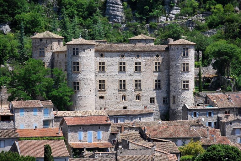
Alba began to decline at the end of the third century and was abandoned by the middle of the fourth century. Viviers probably replaced it as the regional episcopal centre. A medieval settlement later developed at the location of the present village, while the ancient city disappeared from view for more than 1,500 years.
The remains were rediscovered beneath vineyards in the eighteenth century. Jean-Paul Delichères made the first recorded discoveries around 1800, and Honoré Flaugergues excavated at the site between 1819 and 1821. Jos Jullien and Frank Delarbre revived archaeological work from 1935 to 1965, especially at the theatre and Saint-Pierre. Later investigators, including Marcel Le Glay, continued the work, and at least 200 archaeological operations took place over two centuries.
The theatre’s designation as a Historic Monument in 1959 encouraged land acquisition, excavation, and conservation. Since 2001, an archaeological reserve has made the remains accessible to the public, while later investigations have largely involved preventive archaeology. Magnetic and radar surveys introduced from 2019 have helped establish the plan of the ancient city. MuséAl, a Roman museum opened in October 2013, brings together the archaeological site, museum collections, and an archaeological storage and study facility. It displays objects recovered during excavations since the nineteenth century.
The theatre underwent major restoration in the 1980s. A further programme begun on 2 September 2019 studied the monument, consolidated ancient masonry, reduced deterioration, partly recovered its ancient appearance, and improved its use as a performance venue.
Remains
The surviving city is organized around a monumental centre, principal streets, sanctuaries, domestic quarters, baths, cemeteries, and hydraulic works. Its Roman construction used hard limestone, masonry, marble veneers, timber, earth, mosaics, and carefully built vaulted structures. The excavated remains show an urban plan that developed in stages around the cardo maximus, the principal north-south street, and a presumed decumanus maximus, the main east-west street.
Streets and the monumental centre
Cardo maximus and shops
The cardo maximus ran from the river toward and alongside the civic centre. It extended for more than 300 metres and was about five metres wide, with a surface of large blocks of hard limestone known as Lussas marble. Wheel ruts remain visible. The excavated section is approximately 150 metres long, and channels supplying water and carrying sewage ran beneath the road.
Along the western side of the forum, a portico about 4.60 metres wide sheltered approximately twenty shops. Some had upper floors and were reached by four stairways. Five shops contained material from several periods separated by deposits linked to two fires, the earlier probably dating no later than the middle of the second century. Their goods probably included terracotta vessels, moulded votive lamps, and glassware.
Public buildings
The northern part of the forum contained a public building with four porticoed wings around a large garden. Two basins occupied the garden, and the porticoes opened onto semicircular or rectangular recessed spaces. Later alterations made the northern wing more monumental and added an ornamental basin. The building’s precise function remains uncertain. One of its major recessed rooms was vaulted and had a side bench covered with tile mortar. It stood on the eastern side of the building until the middle of the second century.
A second public building stood beside the cardo on the summit of the monumental centre. It may have been connected with economic and religious life and perhaps with trade corporations. Three porticoed wings initially surrounded a garden with a central basin. A wall on the eastern side was converted into a fourth porticoed wing 30 or 40 years later, while a western monumental recessed room was supported by subsidiary rooms.
An inscription probably dating from the first century and later reused on a sarcophagus at Saint-Pierre names four occupational corporations: cloth workers, construction workers, utriclarii, who were associated with transport, and suppliers of construction timber. Their apparent connection with the wine trade illustrates the economic and political strength of such groups, although the attribution of the public building to them remains an interpretation.
Sacred area
The southern part of the monumental centre formed a sacred area with two porticoed buildings arranged from south to north. The southern portico had marble veneers, soft-limestone columns, and a black-and-white geometric floor mosaic. It opened onto a courtyard containing a second-century temple with an entrance porch, a principal inner chamber, and a semicircular niche facing the entrance.
A basilica stood south of the temple. It served as a tribunal and a place for commercial exchange, although it is no longer visible. Farther north, another portico surrounded a courtyard and a large hall ending in an axial apse. This hall may have been the municipal council house. A covered underground passage supported by masonry piles and beams compensated for the slope and was filled in at the end of the first century. The access arch at the northwest corner of the portico survives.
A third urban axis, about 70 metres long and running northeast to southeast, linked the forum with the Bagnols sanctuary. Its orientation indicates an earlier plan for the eastern part of the city.
Bagnols and Basaltes sanctuaries
Bagnols sanctuary
The northern Bagnols district contained a Gallo-Roman sanctuary, housing built partly from perishable earth and wood, and probably craft or commercial activity. The sanctuary began as a Gaulish sacred site in the first century BC and became monumental between about AD 40 and the end of the first century.
Its central temple was connected to a four-sided portico surrounding a courtyard. Two additional temples stood within the complex, one a fanum, a Gallo-Roman temple organized around an inner chamber and sacred enclosure, and the other a temple raised on a platform. The gods worshipped there are unknown, but the imperial cult is represented by a statue found in 1992 and displayed at MuséAl. It shows the emperor Trajan in divine form, nude except for a cloak over his left shoulder. Trajan ruled from AD 98 to 117, and his posthumous deification explains the statue’s divine presentation. Abandonment and the reuse of building stone began by the third century.
Basaltes enclosure
The Basaltes district southwest of the ancient city contained a sacred enclosure bounded by a fence. A temple and two underground chapels stood within it. Excavations in 1987 uncovered more than fifty votive lamps, including miniature examples, together with gold stars placed in fourteen pots. These objects are displayed at MuséAl. The sanctuary dates from the second century AD.
Water management
An extensive underground hydraulic installation was discovered in 1966 about 40 metres south of the paved road, where the national road crosses the Théoule, or Palais, stream. Its principal channel began in the streambed, ran south, and then turned west at a right angle. It was about 60 centimetres wide and 70 centimetres high at its beginning, then quickly increased to more than two metres in height.
The channel had small masonry walls and a barrel vault made from stones set on edge. Openings in the left wall allowed water to enter, while secondary channels in the right wall carried it away. A lower gallery crossed the first part of the main passage. Its vault incorporated reused architectural pieces, including column fragments and slabs. One reused slab bears a dedication to the private individual who paid for a water supply.
The installation may have collected floodwater from the stream and redistributed it for irrigation, groundwater replenishment, and a more regular supply to wells. Other parts of the city used aqueducts from springs on the Coiron slopes, lead or wooden pipes, domestic wells, and masonry sewers. Sewers beside the cardo and decumanus received wastewater and rainwater from numerous gutters.
Theatre
The theatre stood about 150 metres southeast of the forum, on the eastern edge of the city. The Aunas stream passed beneath its stage, an unusual arrangement in Roman theatre construction. The monument developed through three successive forms.
The earliest theatre probably dated from the end of the first century BC. It was a light polygonal structure about 50 metres in diameter, with earth-and-timber seating on the stream’s right bank. The stream was later channelled. A reconstruction carried out no earlier than AD 30 to 45 reshaped the building into a semicircle about 68 metres in diameter and created a crossing over the channelled watercourse.
At the beginning of the second century, a further reconstruction extended the theatre across both banks. The seating area and orchestra occupied the right bank, while the stage crossed the stream and its rear wall stood on the left bank. This final arrangement formed the basis for the modern restoration.
The seating area originally rested on four semicircular, concentric retaining walls supporting 22 rows of seats. One of these walls survives. Spectators entered through vaulted access passages at the rear, reached by external galleries, of which five have been identified. Large semicircular paving slabs remain in the orchestra, where three rows of privileged spectators occupied seats of honour. The actors’ platform stood beyond the orchestra on a wooden covering over the stream.
The stage wall rose to the full height of the theatre, approximately 12 metres. Corinthian columns and statue niches decorated it, and three doors opened toward backstage areas. A garden behind the wall had a portico along its western side. The theatre measured about 68 metres across and could accommodate approximately 3,000 spectators.
The restoration begun in 2019 partly recreated the stage, added a palisade echoing the ancient stage wall, and installed lighting masts indicating the original height of the structure. The work also protected ancient masonry and repaired deteriorating elements of earlier restorations.
Baths and urban houses
La Planchette baths
The private baths known as La Planchette stood southwest of the ancient city, near the entrance to the modern village. Excavated in 1965 and 1966, they contained five rooms arranged from north to south. Their size indicates that they were probably private rather than public.
The first room was probably a changing room. The second was likely a cold room with a three-lobed basin lined with marble on its eastern side and a small bath on its western side. Three further rooms, identified as warm and hot rooms, had small supports holding raised floors. Hot air circulated beneath those floors in a heating system known as a hypocaust.
A rectangular service room lay west of the heated rooms, three steps below them. Another roughly built basin northeast of the three-lobed basin probably served as a reservoir. Coins from the end of the third century and the first half of the fourth indicate use during that period. The baths may have been built in the second or third century and destroyed around the middle of the fourth.
Champ Delauzun houses
Two luxurious houses, known as the Champ Delauzun or Le Pinard houses, were discovered accidentally in 1967 southeast of the city near the Escoutay. Finds included an oil lamp, coins, animal bones, Italian wine amphora fragments, and imported Campanian ceramics. The amphorae and pottery are the oldest remains identified at the site.
A steep east-west street separated the houses. Gutters along it were covered with limestone slabs. The southern house, House I, had a columned courtyard, a garden with a rectangular basin ending in an apse, and a well 10.50 metres deep. Thirteen rooms occupied 1,250 square metres over two storeys, and nine rooms had mosaics.
At the centre of House I, a dining room faced the garden basin and was preceded by a corridor with a mosaic floor. The mosaics, dated stylistically to the first half of the second century AD, used geometric black designs on white backgrounds with restrained colour. A small room retained part of a hypocaust, while a portico along the street survived through several pillar bases.
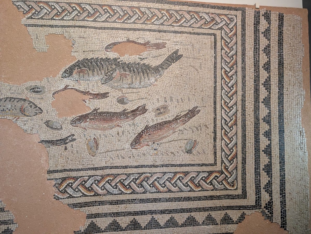
House II, the northern residence, was not aligned with the street. Its mosaics date from the end of the second or beginning of the third century, during the Severan period. One mosaic found in 1967, which covered either a doorway threshold or the floor of a dining room, depicts freshwater fish such as perch and trout, possibly accompanied by tench or carp, together with river mussels.
Saint-Pierre and Saint-Martin
Saint-Pierre complex
Frank Delarbre excavated Saint-Pierre from 1945, and further investigations took place between 1964 and 1976. Deep layers contained first-century marble fragments, frescoes, and pottery sherds. Three major monuments were superimposed there between antiquity and the Middle Ages.
The earliest substantial monument probably dates from the late second or early third century, during the reign of Septimius Severus. Its surviving elements include a paved surface with a gutter, three parallel walls forming a portico 3.50 metres wide, a hall 5.90 metres deep, and a basin measuring 10.75 by 7 by 1.56 metres.
A smaller building to the south measured about 16 by 9.5 metres. Its square plan extended west to east into a raised room about five metres square. It may have been a martyrium, a Christian shrine associated with a martyr or holy relic, and was later changed into a three-aisled church. A paved corridor 2.50 metres wide approached from the north. Beyond the threshold, a paved courtyard measuring 4.50 by 3.50 metres led to a baptistery, a structure or basin used for Christian baptism.
Farther north stood a larger church extending from west to east, with several aisles and a paved floor. It may later have served as Alba’s cathedral. Three levels of burials were identified: Roman-style graves below the pavement, Merovingian sarcophagi, and medieval graves above it.
Medieval priory
A priory was established farther north in the twelfth century. Its chapel measured 20.50 by four metres and consisted of an entrance hall, a nave, and a choir. Repeated alterations changed the building. It was partly destroyed in the sixteenth century and abandoned in the seventeenth.
Saint-Martin cemetery and suburbs
Saint-Martin, also called La Plaine, marked the transition from the urban area to the countryside. A suburban villa and a Gallo-Roman cemetery stood south of the national road, near the later church and medieval cemetery. Other peripheral residences, agricultural estates, and dwellings included gardens, porticoes, water basins, and mosaics, extending the archaeological picture beyond Alba’s monumental centre.