Halaesa Arconidea: Ancient Sicilian-Greek City and Roman Municipium in Italy


Site at a Glance
- Rating
- 4.5
- Popularity
- Low
- Country
- Italy
- Primary era
- Classical
- External website
- Open
- Eras represented
- Classical, Medieval
- Civilizations
- Ancient Greek, Norman, Roman
- Site type
- City
On this page23 sections
History
Halaesa Arconidea is an ancient Sicilian-Greek city in Italy, in the territory of present-day Tusa on Sicily’s northern coast. Founded in 403 BC by Archonides, the dynastic ruler of Herbita, it occupied a hill about eight ancient stadia from the sea and developed into an important city before becoming a Roman municipium, a community whose inhabitants held Roman citizenship.
Foundation and frontier position
Halaesa arose after the peace concluded with Syracuse under Dionysius, the Syracusan tyrant. Archonides granted part of the northern territory to Siculi who had supported him during the war, and the new settlement took its name from its founder. Its territory lay between the Tyrrhenian coast, the Tusa River, and the Pollina River.
The city was established near a Campanian mercenary settlement that Carthage had installed after its peace with Syracuse in 405 BC. Halaesa therefore stood close to the frontier of Carthaginian influence and had a defensive role against possible expansion from that quarter. Its coins showed a column topped by a dog, an emblem of territorial control that survives in the civic arms of Tusa.
Religious evidence points to links with several parts of Sicily. A temple of Adrano, an ancient Sicilian deity especially associated with the region around Mount Etna, may indicate that some settlers came from that area. A shrine or temple of Venus Erycina, the form of Venus worshipped at the sanctuary on Mount Eryx, may also have existed at Halaesa. A fragmentary marble female statuette from a small shrine has been interpreted in this connection.
The Sicilian-Greek alliance
In 339 BC Halaesa joined the Sicilian-Greek alliance led by Timoleon, a Corinthian military leader and statesman. He had come to Sicily to overthrow the Syracusan tyrant Trasibulus, establish democratic institutions, and protect allied cities from aristocratic and tyrannical governments as well as from Carthage. Halaesa quickly became one of the alliance’s leading cities.
The city was also one of sixteen communities assigned in rotation to provide a garrison for the sanctuary of Venus Erycina at Eryx. These cities were said to claim Trojan origins, a tradition that connected their civic identities with the legendary ancestry of the sanctuary and its wider religious community.
Alliance with Rome and civic autonomy
When Roman forces landed in Sicily in 263 BC, Halaesa allied itself with Rome. After the province of Sicily was established in 241 BC, Rome granted the city the status of civitas libera ac immunis. This privileged civic position allowed local autonomy and exemption from tribute. It encouraged economic and demographic growth, while Halaesa retained its own coinage, including silver issues.
The city’s political organization was regulated in 96 BC by the praetor Gaius Claudius Pulcher. He set minimum age and property requirements for membership in Halaesa’s city senate and consulted resident members of the patrician Marcelli family. In gratitude, the city dedicated a marble statue to him. Found in the eighteenth century, the statue is now kept in the council chamber of Tusa.
Halaesa also contributed to Roman naval activity in Sicily. Cicero states that the city supplied ships and crews to the Sicilian fleet, and an inscription commemorates a naval victory achieved by ships from Halaesa and other cities under the command of Caninius Niger.
Roman and late antique Halaesa
During the Augustan period, Halaesa became a municipium and its inhabitants acquired Roman citizenship. The city continued to exist at least until the end of the fourth century and appears on the Peutinger Map, a late Roman map of the imperial road network.
By the middle of the fifth century, Halaesa was probably an episcopal seat. A Greek inscription mentions a bishop named Tobias. In 522, the Roman patrician Tertullus donated land from his territory to Montecassino Abbey, and a monastery at Halaesa may have been founded late in the sixth century among the Sicilian foundations associated with Gregory the Great.
Halaesa remained among Sicily’s fourteen important cities in the seventh century. Its bishop, whose name is rendered as Calunnioso, attended the Lateran Council in Rome in 649. In 870, Bishop Antonio of Halaesa attended a council in Constantinople. Under Byzantine rule, Sicilian bishops belonged to the patriarchate of Constantinople.
Destruction, abandonment, and medieval reuse
Arabic accounts describe the plundering of the countryside around a place called Lyasah in 835 and 836. The settlement may have been Halaesa, and defending forces compelled the raiders to withdraw. A tower in the Tusa River valley may belong to this period, serving as a signal station between Halaesa and neighboring communities defending themselves against Arab incursions.
The city appears to have been abandoned after destruction caused by a severe earthquake, possibly the earthquake recorded in 856. Its population may then have moved to the more easily defended site of modern Tusa. The exact circumstances of the Arab conquest remain uncertain, but it probably occurred after the fall of Syracuse in 878. An Arab fortress called Qalat al-Qawarib was later installed in the abandoned city to protect the port.
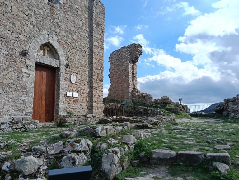
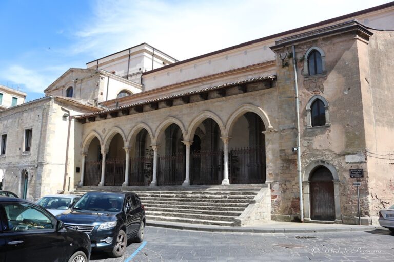
Medieval use continued beside the ruins. The church of Santa Maria delle Palate stands beside the custodian’s house. During the Norman period it housed a Benedictine monastery and cloister belonging to the resident abbot of the Church of Saint Bartholomew in Lipari. Legal documents first mention the church in 1123, and Pasqualino Scaluni restored it in 1551.
Rediscovery and archaeological investigation
The archaeological rediscovery of Halaesa is recorded in 1552. Six years later, two marble slabs known as the Alesine Tablets were found among the ruins. They carried a detailed Greek description of Halaesa’s territory. The Society of Jesus in Palermo initially kept them, but they were apparently taken to Spain in the eighteenth century and later lost. Their incomplete text was published in 1753, while a further fragment found in 1885 was also lost. A third fragment, possibly from the same inscription, is preserved at the University of Messina and was published in 1961.
The surviving text describes a territorial division into twelve lots on the Tusa River side, twelve on the Cicero River side, and three further lots called the Scironi along the ridge between the two valleys. It also mentions a sacred double lot near the Opicano River, where butchers and tanners were forbidden to enter, together with four temples, baths, an aqueduct, the Ipurra spring, the Tapanon, and the Tematetis.
Excavations took place in 1942, from 1952 to 1954, between 1970 and 2009, and from 2016 onward. The work by the Superintendency for Cultural and Environmental Heritage of Messina, the Universities of Palermo and Messina, Oxford University, and the University of Picardie Jules Verne has exposed parts of the fortifications, the agora, the main street, and sections of the urban fabric.
Remains
The archaeological area covers approximately 160,000 square metres on a hill near the sea. Its fortification circuit extended for about 3 kilometres and followed the hill’s irregular contours. Within the walls, streets organized the urban quarters into regular terraces, while the agora occupied a central terrace open toward the east and the Tusa River valley.
Fortifications and streets
City walls and gates
The fourth-century-BC fortifications were built in pseudo-isodomic ashlar masonry, with courses of schistose sandstone blocks forming the inner and outer faces. Rubble masonry filled the space between them. Later repairs included repointed joints and replacement blocks selected for greater resistance to weathering. Towers connected by a wall-walk formed part of the circuit.
At least four gates are known. Two stood on the northeast side, while one opened on the southeast and another on the southwest. The southeastern and southwestern gates were the principal exits for roads leading toward the port, Herbita, and other inland settlements.
Street network
The urban plan was organized around the principal north-south street, the cardo maximus. About 6 metres wide, it was paved with square stone slabs set in a checkerboard pattern. Cross streets measured between 2.30 and 3.30 metres in width and were spaced about 32 metres apart, forming regular insulae, or city blocks, arranged as terraces on the slopes. The arrangement resembles the urban plan visible at Soluntum. On the steepest ground, some smaller streets became stairways.
Agora and civic terraces
Central agora
The agora, the principal public square of a Greek city, was established in the second century BC and remodeled during the imperial period. A retaining wall closed its western side, with a road running above it. The square was paved with bricks and had a system for collecting and disposing of rainwater. Statue bases stood within the space, together with a larger square podium made in opus reticulatum, a Roman wall technique using small diamond-set pieces arranged in a net-like pattern. The podium was probably faced with marble and may have served as a speaking platform.
Double portico and cult chambers
A monumental double portico, a covered colonnade, formed an L around the western and northern sides of the agora. It stood about 50 centimetres above the square. Its outer stone columns supported a Doric entablature of stuccoed wood, while its inner brick columns were coated with stucco and carried stuccoed, painted capitals.
Eight divided rooms opened behind the portico, six on the western side and two on the northern side. The retaining wall served as their rear wall. Their inner compartments contained statue niches and altars, indicating use as cult chambers. One room may have been reserved for the imperial cult administered by the seviri Augustales, officials associated with that worship, and had an elaborate covering of colored marble. Another contained a large group of marble inscriptions.
The agora developed through at least three phases. The cult chambers came first, followed by a single portico that was later subdivided internally by additional columns.
Lower terrace and possible gymnasium
A lower terrace lies about 2.50 metres beneath the agora. Its 39-metre retaining wall uses isodomic ashlar masonry made from large rusticated blocks of non-local Mistretta quartzarenite. Built before the Roman conquest, the wall supported the terrace carrying the main street.
Some upper blocks served as bases for large columns, and statue bases were also found. One may have supported a statue of the Syracusan Siceliot king Hiero II. The complex may be the gymnasium mentioned by Cicero, a Greek civic institution associated with physical training and education. A staircase probably connected it with the higher part of the agora.
Residential and infrastructural remains
Residential quarters and basin building
Residential quarters have been exposed below the agora. One building was constructed more robustly than the neighboring houses and contains a large square basin edged with blocks of hard stone. The basin was probably surrounded by a colonnade. The structure may have been another public building or the peristyle, a courtyard surrounded by columns, of an especially wealthy house.
Northeastern viaduct
Above the northeast gate, a largely buried masonry structure follows an arc of approximately 120 metres. Known as the “buttresses,” it has been interpreted as a viaduct supporting one of the principal roads. Some rooms within it had rich decoration, including fragments of a stucco inscription.
Waterworks and territory
The possible bath complex at Case Gravina retains its mosaics and may correspond to the baths mentioned in the Alesine Tablets. A bridge over the Tusa River, called Ponte Riggieri, may be ancient, although its date appears to be later. At Fruscio, the Viviere water installations gathered a group of springs for the city aqueduct.
The area around present-day Contrada Ospedale, halfway between Halaesa and Tusa, may correspond to the “Via Xenide” named in the Alesine Tablets because of the similarity between the meanings of the place names. If this identification is correct, the area may have contained the temple of Adrano, the Tapanon, and the Tematetis.
Acropolis, necropolis, and later structures
Acropolis temples
The acropolis occupied the highest part of the hill and contained three temple platforms. Its sanctuary consisted of two lateral temples and a larger central temple probably dedicated to Apollo. Apollo was Halaesa’s tutelary deity, associated with the city’s protection. Two Halaesan inscriptions, literary evidence, and local coins showing the god’s head beside a lyre support this identification.
Roman columbarium
A Roman columbarium stands outside the walls in front of the two southern gates. This funerary building has lost its original vaulted roof, but its opus reticulatum walls retain niches for cremation urns. It marks the location of the Roman necropolis, while the older Sicilian-Greek necropolis is known in the surrounding area.
Medieval church and surviving objects
Santa Maria delle Palate preserves original painted wooden statues, including a Madonna and Christ holding a globe made by the Gagini school, a Sicilian workshop tradition associated with the sculptor family and artistic school of the Gagini. The church also contains a medieval crucifix. Its back retains the original wood of the cross, now supported by a wooden framework.
The Giacomo Scibona antiquarium at Halaesa houses a second-century AD marble statue of Ceres, the Roman goddess associated with agriculture, grain, fertility, and motherhood. Tower Migaido, a central keep in the Tusa River valley, dates to the Norman conquest and belongs to the final phase of Halaesa’s history.