Fort de Tamié: An Alpine Fort in the Albertville Fortified Position


Site at a Glance
- Rating
- 4.5
- Popularity
- Medium
- Country
- France
- Primary era
- Modern
- External website
- Open
- Eras represented
- Modern
- Civilizations
- French
- Site type
- Military
- Remains
- Fort
On this page9 sections
History
Fort de Tamié is an Alpine mountain fort in France, west of Mercury in Savoie, built between 1876 and 1881 as part of the fortified position of Albertville. Constructed by 600 Italian workers, it belonged to the Séré de Rivières system, France’s network of forts and defensive works developed mainly after the Franco-Prussian War of 1870–1871. Its position allowed it to control the Tamié pass and the valley leading from Faverges.
Construction and military role
The fort was built on the former locality of Châtelard because planners feared that Italian forces might bypass Albertville through Switzerland. Its guns could engage Albertville and its bridges, as well as the direction of Seythenex. The fort also provided all-round defense and was intended to serve as the final redoubt of the fortified position if Albertville’s defenses were forced.
Within the Albertville defenses, Fort de Tamié was regarded as the redoubt, and sometimes as the center of resistance. Its role combined control of the pass with protection of the approaches from several directions, making it an important part of the wider defensive arrangement.
The temporary name Fort Brissac
Under a decree dated 21 January 1887, War Minister Georges Boulanger temporarily renamed the fort Fort Brissac. Boulanger was a French general and politician who served as Minister of War in 1886 and 1887. The new name referred to Charles I de Cossé-Brissac, a sixteenth-century French marshal who captured Vercelli in 1553 and seized the treasury of the Duke of Savoy.
The decree was annulled on 13 October 1887, and the fort officially returned to the name Fort de Tamié.
Later ownership and use
In 1968, the fort was sold to an intercommunal syndicate. Its grounds were later adapted for recreational use, including a botanical trail and an aerial adventure course, while the buildings became available for weddings and other events. A replica of a 120 mm L de Bange cannon was inaugurated at the fort on 1 July 2006.
Remains
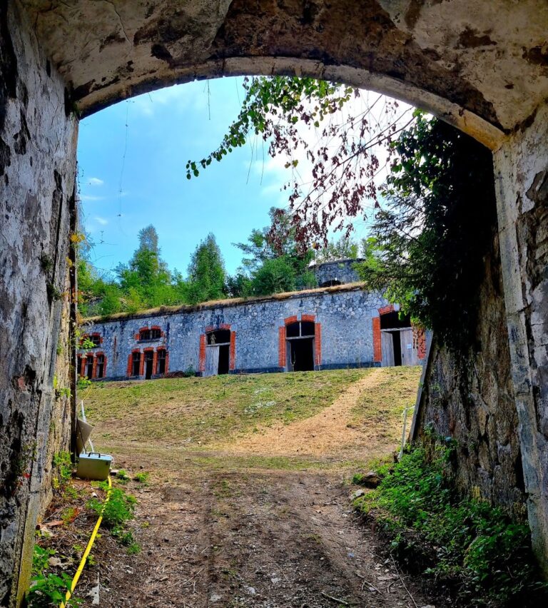
Fort de Tamié occupies a rocky spur at an altitude of 992 metres, rising to 1,021 metres. It stands about 200 metres west of the Tamié pass, which lies at 907 metres, above the Tamié valley to the northwest and the Combe de Savoie to the southeast. The floor of the Combe de Savoie is at 315 metres. The fort is a first-generation Séré de Rivières mountain fort, with a defensive perimeter adapted to the shape of the ground.
Defensive perimeter and artillery
The bastioned enceinte, or defensive perimeter with projecting bastions, enclosed 10.8 hectares and measured 589 metres from southwest to northeast and 240 metres from east to west. The fort as a whole extended over about 16 hectares, with approximately 1,800 metres of enceinte. Its interior contained broad artillery platforms covering the northern and southern approaches.
The planned armament comprised 36 pieces, including six guns assigned to flank the defenses. In 1879, the rampart armament consisted of 12 cannons and six mortars, supported by six flanking pieces. A section of ditch was protected by three caponiers, covered firing positions designed to shoot along the ditch. Two stood at Bastion 2, while a third, built on two levels, occupied Bastion 3.
Other stretches of the inner ditch slope, or escarp, were protected by a parapet wall or by crenellation. These defenses included the steep slope southwest of the rock-cut barracks. The arrangement connected the bastions, ditch defenses, and artillery platforms to the fort’s all-round defensive purpose.
Rock-cut accommodation and magazines
Rock-cut barracks
The initial design provided accommodation casemates, protected vaulted chambers, only in the entrance building, so the garrison was intended to live in an encampment. Eight chambers were later excavated directly into the rock at the top of a precipice behind Bastion 1. A ramp above this rock-cut accommodation connected it with several artillery platforms.
Powder magazines
Three magazines were excavated in the rock for ammunition storage. One stood to the left of the rock-cut accommodation, while another opened almost directly opposite the entrance into the curtain wall, the section of wall between two bastions, between Bastions 4 and 5. An assisted-movement drawbridge lay beneath the latter magazine.
Two powder magazines facing one another were served by the same vestibule. Together they had three lamp loopholes, small openings for controlled lighting, with the middle loophole positioned unusually lower than the other two. The surviving rock-cut spaces and their connections show how accommodation, ammunition storage, and artillery positions were integrated into the rocky site.
Nearby sites