Pampus: A Fortified Island Defending Amsterdam’s Harbour


Site at a Glance
- Rating
- 4.4
- Popularity
- Medium
- Country
- Netherlands
- Primary era
- Modern
- External website
- Open
- Eras represented
- Modern
- Civilizations
- Dutch
- Site type
- Military
- Remains
- Fort
On this page12 sections
History
Pampus is an artificial fortified island in the Netherlands, near Amsterdam, built by the Dutch government between 1887 and 1895 to defend the Pampus navigation channel, the entrance to the IJ and Amsterdam’s harbour. It formed part of the Defence Line of Amsterdam, a nineteenth-century system of forts, batteries, inundation works and related installations designed to protect the capital by controlling access routes and flooding surrounding land where possible.
Planning and construction
After the Franco-Prussian War of 1870, the Netherlands feared that Amsterdam could face attack. In 1879, Member of Parliament Jan Willem Rutgers van Rozenburg proposed a permanent fort on the Muiderzand, south of the Pampus shallows. The proposed position was intended to work with batteries on Lighthouse Island near Durgerdam and at the Diemer seawall.
The Minister of War approved construction in the 1885 budget in 1884. Work began in 1887, and the fort was completed in 1895. On 20 August of that year, the Minister of War transferred it to the artillery. A dispute between Amsterdam and Muiden over responsibility for the fort was settled by Royal Decree on 7 April 1891, when Pampus was assigned to the municipality of Muiden. Muiden later became part of Gooise Meren.
The fort’s 4th company belonged to the Armoured-Fort Artillery Corps. It had been formed by 1893 and assembled at the Muiden garrison on 1 May under Captain L. C. Dyxhoorn. Pampus was one of only four forts in the Defence Line equipped with large-calibre guns. Its planned full complement was approximately 200 soldiers, a strength it reached only during the First World War. Despite its armament and strategic purpose, the fort never took part in a military action.
Changing strategic importance
Three concrete platforms for anti-aircraft guns were added in 1926 and 1927 to help defend Amsterdam. The guns were removed in 1934. The completion of the Afsluitdijk in 1932, a major Dutch dam that closed the former Zuiderzee and created the IJsselmeer, changed the sea conditions around the fort and reduced its strategic importance. Pampus was closed and abandoned by the military in 1933.
At the beginning of the Second World War, Pampus played no significant role in the defence of the Netherlands. German forces used the island for dive-bomber target practice with concrete bombs of approximately 250 kilograms, which released coloured smoke when they struck. An anti-aircraft battery was later installed there.
During the German occupation, the fort’s Krupp guns, armour, cupolas and other metal fittings were removed for scrap and transport to Germany. Explosives destroyed the armoured structures surrounding the two main gun cupolas, which were then dismantled. In the severe winter of 1944 to 1945, ice made the island reachable on foot, and local inhabitants removed timber from the fort for fuel. After the German surrender, the mine-clearance service used the island to detonate ammunition that could no longer be safely defused.
Decline and preservation
Plans were considered in 1951 for placing an anti-aircraft battery on Pampus, but on 9 October 1952 the fort was abolished as a military work and transferred to civilian authorities for disposal. It subsequently fell into decline. In 1965, the architectural firm Van den Broek and Bakema, comprising Jo van den Broek and Jaap Bakema, prepared a plan for a city on the island. The project was never built.
The government surveyed Pampus in June 1985 with a view to restoration and public opening. Restoration plans followed in 1986, and the Pampus Foundation was established to carry them out. The foundation bought the fort in 1990 and appointed a caretaker in 1992. The fort has been continuously occupied since then.
The Defence Line of Amsterdam, including its 42 forts, became a UNESCO World Heritage Site in 1996. Pampus is also a Dutch national monument. The main building was renovated in 2007, and its interior was partly restored and adapted for museum use. The island’s mist-clock house was restored in 2020. It originally served as a bell tower warning shipping during fog.
The island has not been connected to mainland electricity, gas or water networks since the nineteenth century, so the fort had to function independently. Its name is associated with the Dutch expression “laying for Pampus,” referring to ships that once waited for high tide at the shallow channel before entering Amsterdam’s harbour.
Remains
Island and fort structure
Pampus lies in the IJmeer on the former Zuiderzee shallows. The artificial island measures approximately 205 metres by 164 metres and covers about 0.03 square kilometres. Its highest point is approximately 13.3 metres above the Amsterdam Ordnance Datum, at the lighthouse or light beacon. To form the island, mud was dredged down to the sandbank and replaced with clean sand. Mattress-like foundation structures, rubble and basalt blocks stabilised the ground, while the fort itself stands on 3,852 piles, each 11 metres long.
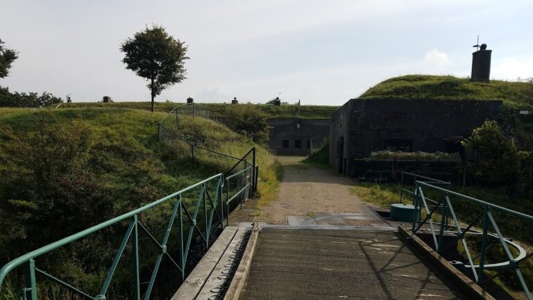
The oval fort combines concrete with brick masonry. An eight-metre-wide dry moat surrounds the main building. Hollow passages on the north and south connect the lower floor with the counterscarp, the outer defensive wall or slope on the far side of a moat. The concrete counterscarp contains an arrest room or gaol, a forge and several storage rooms. A passage runs through it, with positions from which parts of the dry moat could be fired upon. A parapet on top provided cover for close defence, while a broad glacis, a gently sloping bank of earth shielding a fort from attacking fire, protected the entire position.
Main building
Lower floor and services
The main building had lower and upper floors, with a small intermediate level. The lower floor contained troop quarters, a kitchen, washrooms, two coal-fired steam boilers, two 20-horsepower steam engines, two dynamos, a telegraph, a medical or first-aid room and magazines for cartridges, shells and gunpowder. Most rooms were placed on the southern side, which was considered safer during an attack.
Rainwater collected in water basins was stored in a dedicated reservoir, providing the fort with an independent water supply. Shells and cartridges were raised from the lower-floor magazines by lifts through the hoisting room. This arrangement supported the fort’s ability to operate without connections to mainland utility networks.
Upper floor and gun armament
The upper floor contained two rotating armoured cupolas, each a rotating armoured gun turret equipped with two Krupp-Gruson 24-centimetre L/35 guns. Together, the cupolas carried four large guns. The floor also held an observation cupola and two positions intended for three 5.7-centimetre L/25 quick-firing guns each.
Each large gun required six gunners and one non-commissioned officer, a rank below commissioned officer but above ordinary enlisted personnel. A gun needed approximately six minutes before it was ready to fire again. With four guns, the fort could theoretically fire a shell every one and a half minutes, while the stated overall firing rate was approximately one shot every eight minutes. The large guns had a range of approximately eight kilometres. Their shells weighed about 200 to 250 kilograms and measured approximately 0.86 to 1.25 metres, depending on the type.
A large hand-operated wheel beneath the main guns allowed the armoured cupolas to be turned if steam power was unavailable. A small command post gave access to the observation cupola and connected with relevant parts of the fort through seven speaking tubes. Four Gardner M90 machine guns on protected casemate mounts, meaning weapon positions set within protected chambers or emplacements, were incorporated into the counterscarp to defend the dry moat.
Later features and surviving fabric
Anti-aircraft platforms and harbour
Three concrete platforms for anti-aircraft guns were added to the island in 1926 and 1927. The guns were removed in 1934. The harbour lies on the southern side of Pampus, and a low wall slightly below water level surrounds the island.
Armament and restoration
The original gun positions, armoured cupolas and other metal fittings were removed during the Second World War, so the original steel cupolas no longer survive. The main building’s walls have been conserved and its roof has been made watertight. The replacement cupolas installed during the 2007 renovation are made of wood with a water-resistant coating rather than the original steel.
One 88-millimetre gun from a German minesweeper wrecked during a storm north of Terschelling in 1917 was later recovered by dredging and donated to the Pampus Foundation. It was installed at Pampus harbour on 4 February 2003. The island also contains the mist-clock house restored in 2020, the former bell tower used to warn shipping during fog.