Bastille: The Nineteenth-Century Fortress of Grenoble, France


Site at a Glance
- Rating
- 4.6
- Popularity
- Medium
- Country
- France
- Primary era
- Modern
- External website
- Open
- Eras represented
- Early Modern, Modern
- Civilizations
- French
- Site type
- Military
- Remains
- Fort
On this page11 sections
History
Bastille is a nineteenth-century military fortress in Grenoble, France, built by French military engineers on the northern heights of the city. Construction ran from 1824 to 1847, producing a fortified complex intended to defend Grenoble against an attack from Savoy through the Chartreuse. Its military purpose declined after Savoy became part of France in 1860, and the fortress was never used in wartime.
Early Fortifications on the Hill
The hill had a fortified residence before it became the site of the later Bastille. In 1470, Eynard Pradel, an auditor of the Dauphine financial court, leased land above Grenoble and built a residence protected by two towers, each about 20 metres high. After his death in 1507, the property passed to Hugues Pinel in 1512 and then to Bertrand Rabot in 1513. The Rabot family retained it for 122 years, giving its name to the later Fort Rabot.
Several attempts were made to strengthen the heights. Francis I, king of France from 1515 to 1547, intended to enlarge Grenoble’s fortifications in 1515. Further proposals followed in 1538 and 1566, but the larger schemes were not completed. A small military fort was built on the summit in 1537, along with a redoubt, a small detached defensive work, on the slope toward La Tronche.
Lesdiguieres and the Seventeenth-Century Defenses
In December 1590, Francois de Lesdiguieres captured Catholic Grenoble after a siege lasting more than three weeks. Lesdiguieres was a leading Huguenot military commander and governor of Grenoble. Huguenots were French Protestants who played a major part in the sixteenth-century French Wars of Religion. In 1591, as governor, he ordered a small citadel around the Tour de l’Isle, a square historic tower beside the Isere, and a bastille on the hill. The hilltop work was designed to prevent an enemy approaching from the Chartreuse from reaching the city unseen, and it was completed in 1592.
Lesdiguieres also demolished Grenoble’s thirteen-century-old Roman enclosing wall because it could no longer withstand artillery. He replaced it with a new defensive enclosure containing six bastions, projecting structures that allowed fire along adjoining walls, and two half-bastions. The enclosure was completed in December 1606, incorporated the suburbs, and increased the protected urban area by 21 hectares.
The first work was directed by the Piedmontese architect Ercole Negro, followed from 1611 by the royal engineer Jean de Beins. Two fortified branches descended from the hill toward the Isere and the new Porte Saint-Laurent and Porte de France. The branches were completed in July 1619, while the two gates were finished in 1615 and 1620. Their construction also created a route cut into the rock beside the river, avoiding the dangerous riverside passage and the Chalemont spur.
Decline and Haxo’s Reconstruction
During an inspection of Alpine fortifications in September 1692, the military engineer Vauban warned Louis XIV that Grenoble’s defenses, particularly those of the Bastille, were weak, unfinished, and poorly maintained. Vauban was a prominent French engineer who designed and inspected fortified systems under Louis XIV. Most of his proposed improvements, including a plan to enlarge Grenoble’s southern defensive enclosure, were abandoned. Only earthworks and two powder magazines were completed.
Military interest declined during the eighteenth century because no immediate Alpine frontier threat was perceived. Grenoble’s fortifications deteriorated, while floods of the Isere in 1733 and 1741 diverted resources. Plans developed between 1741 and 1787 to divert the river south of the city for defensive purposes were abandoned in 1790.
The treaties of Fontainebleau in 1814 and Paris in 1815 returned Grenoble to a frontier position opposite the Kingdom of Sardinia. In 1815, Louis XVIII ordered stronger border defenses, and in 1816 he assigned General Francois Nicolas Benoit Haxo to modernize Grenoble’s obsolete and dilapidated fortifications. Military engineers surveyed the defenses between 1816 and 1820. After several proposals, the Fort Bastille project received approval from the Fortifications Committee in Paris on 29 August 1823. Construction began on 16 April 1824 under Commander Antoine Tournadre and ended on 27 February 1847, after 23 years of work.
Obsolescence and Civilian Transformation
The fortress was incorporated into Grenoble’s fortified belt in the 1870s, although its military value was already declining. The annexation of Savoy by France in 1860 removed the threat for which the fortress had been built, while rifled artillery and explosive shells reduced the effectiveness of its defenses. The Bastille and the later city ramparts were never used in wartime. A small garrison remained until 1940.
The former barracks became a restaurant in 1934, the year the Grenoble-Bastille cableway entered service. The cableway was partly rebuilt in 1951 and substantially rebuilt in 1976. The City of Grenoble acquired the whole fortress complex in 1970 and opened the footpath now used to reach the Bastille in 1973. The military works entered the register of historic monuments in 1989.
The complex has since taken on cultural and educational uses. Since 1979, the lowest casemate at Place Saint-Laurent has housed Grenoble’s Centre of Scientific, Technical and Industrial Culture. Other casemates have housed the Centre d’Art Bastille since 2006 and the Museum of Mountain Troops since 2009. Fort Rabot has belonged to the University of Grenoble since 1970 and is used as student accommodation. Records of the artillery inventory list 22 pieces at the Bastille in 1879, 83 in 1884, and 26 in 1913. A wider inventory covering the Bastille, Fort Rabot, and neighboring works lists 38 pieces in 1879, 81 in 1890, and 53 in 1913, including 26 at the Bastille.
Remains
Setting and Defensive Layout
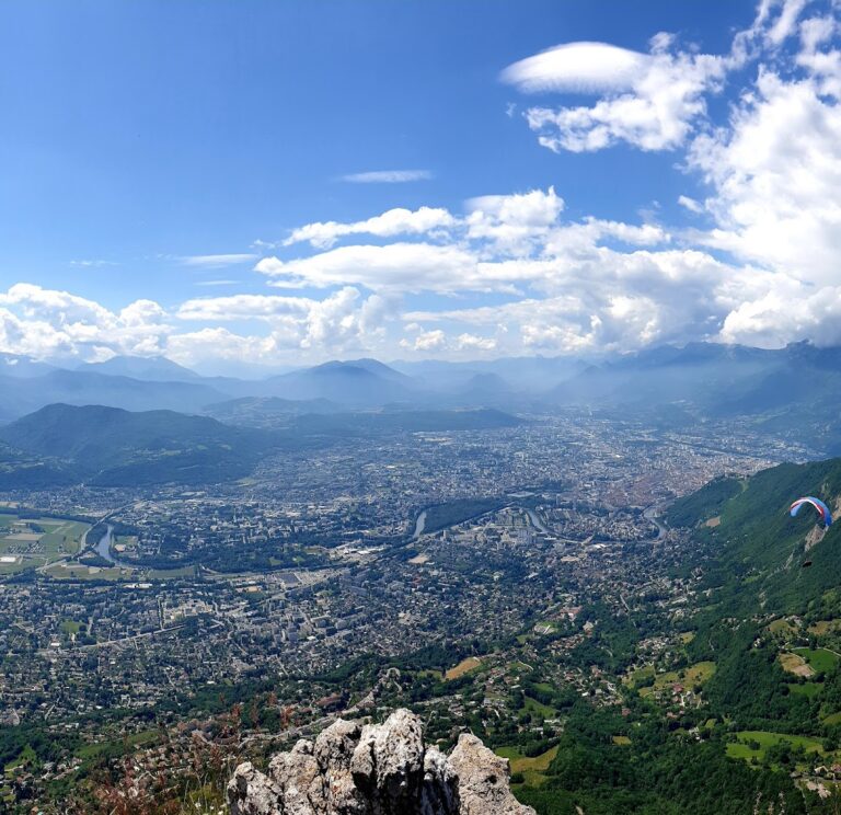
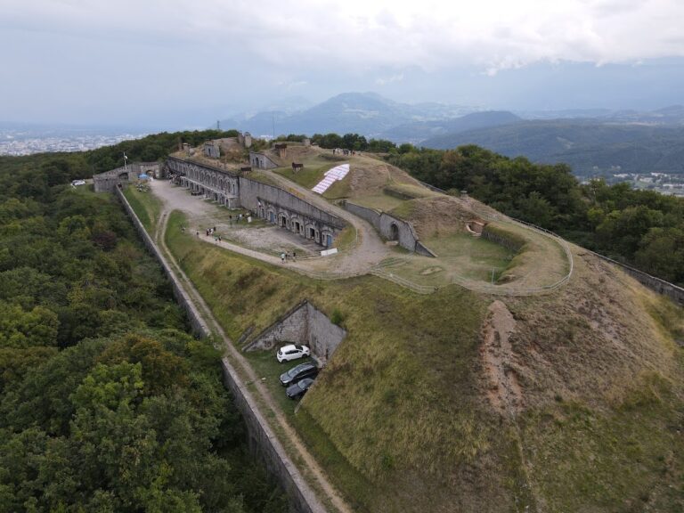
The fortress occupies the final promontory of Mont Rachais at the southern end of the Chartreuse range, on the boundary between Grenoble and Saint-Martin-le-Vinoux. It stands at about 476 metres above sea level, approximately 264 metres above Grenoble and the Isere valley. The main platform rests on a glacially formed shoulder above a notably flat valley. The retreat of the Isere glacier about 25,000 years ago left a lake that lasted for more than 10,000 years; later lake sediments formed the present flat valley floors.
Cliffs, steep slopes, and rocky ground made the position difficult to attack, while Mont Jalla rises above it to the north. The fortress is oriented toward the Chartreuse rather than Grenoble because artillery of the period was considered too inaccurate for effective fire on the city below. Its main defenses follow the terrain and were intended to be concealed by vegetation. A roughly horizontal bastioned curtain wall, a connecting defensive wall, extends about 500 metres across the upper third of the hill and links the eastern and western branches.
Main Fort and Western Branch
Built mainly from stone quarried below the Porte de France and hauled up the slopes by mule, the modern fortress was positioned using contour plans that calculated the works’ height and location across rocky ground, cliffs, and scree. On the western side, above the Porte de France, Haxo retained the line of the seventeenth-century walls but enlarged it with bastions and casemates, fortified chambers used for guns, troops, or storage.
The main fort replaced the 1592 bastille and is a rectilinear, three-storey structure of dressed-stone casemates. A moat and a glacis, a sloping area intended to expose attackers to defensive fire, precede it. Access crosses the moat by a drawbridge. In 1833, Captain Gueze devised a counterweight system using hollow cast-iron weights fitted inside one another, reducing the force needed to raise the bridge.
The vaulted casemates contain artillery embrasures, with firing benches for riflemen above them. Their rear openings helped disperse smoke produced by black-powder weapons. A glacis and ditches separate the main fort from the mountain, while two half-bastions defend the ditch and provide crossing fire against approaches.
Barracks and Fort Rabot
A barracks was built beside the main fort between 1827 and 1838 for about 100 men, officers, and non-commissioned officers. A powder magazine was added below it in 1836. Its roof has collapsed, but the structure remains visible from the Vauban viewpoint.
Fort Rabot was built on the lower western slope between 1840 and 1847, within the defensive walls and near the earlier Rabot fortified house. About 50 metres above the city, it could accommodate up to 900 troops and officers. The fort included artillery shelters and a powder magazine placed away from the probable attack front. Its monumental entrance had a drawbridge.
Eastern Branch and Underground Batteries
Toward the Porte Saint-Laurent, Haxo used a straighter line than Lesdiguieres. A staircase of 380 steps climbs from the Isere embankment toward the fortress, with landings and perpendicular steps leading to the parapet. A casemate and a protected tunnel were built near Saint-Laurent Church because the new fortifications extended almost to the church. The Porte Saint-Laurent and Porte de France survive, while remnants of the earlier connecting defenses include several sentry turrets, a tower-shaped staircase in the Jardin des Dauphins, and bastions along the road from La Tronche.
In 1844, linked caverns were cut into the cliffs of Mont Jalla in front of the fortress. A concealed path and underground passage connected them with the fort’s drawbridge. The cavern batteries could store munitions and fire against attackers from the rear, placing an attacking force between opposing lines of fire. Locally, the caverns are called the Mandrin Caves, although the name is anachronistic because the Dauphine bandit associated with it died about 90 years before the caverns were constructed.
Later Installations
Two communications pylons stand within the fortress and carry transmitters used by Grenoble security services and Radio Kol Hachalom. Together with the surviving gates, casemates, branches, curtain wall, underground batteries, and associated Fort Rabot, they form the physical remains of the defensive complex developed on the hill from the sixteenth to the nineteenth century.
Nearby sites