Burg Milnrode: An Abandoned Medieval Castle in Germany


Site at a Glance
- Rating
- 4.1
- Popularity
- Very Low
- Country
- Germany
- Primary era
- Medieval
- Eras represented
- Medieval
- Civilizations
- Holy Roman Empire
- Site type
- Military
- Remains
- Castle
On this page13 sections
History
Burg Milnrode is an abandoned medieval castle in Germany, above Asbach, now part of Bad Hersfeld in Hesse. The Lords of Milnrode probably built it before 1184 on behalf of Hersfeld Abbey, a major imperial abbey whose abbots controlled land and exercised authority across the surrounding region. The castle belonged to the abbey’s feudal system, while the Milnrode family held it as tenants and served the institution as ministeriales, medieval service nobles who performed administrative and military duties.
Foundation under Hersfeld Abbey
The first recorded member of the family is Folpertus de Milnrode, a ministerial of Hersfeld Abbey mentioned in 1184. Archaeological material, especially pottery and other finds from the twelfth and thirteenth centuries, supports a construction date before that reference. Excavations carried out between 1957 and 1967 also support the interpretation that the Lords of Milnrode established the castle as a new foundation for the abbot rather than taking over an earlier building.
The family’s possessions extended across the surrounding countryside, including properties in Friedewald, Motzfeld, Ausbach, Kircheim, Gittersdorf, Asbach, and Beiershausen. A deserted settlement near Motzfeld called Milnrode may preserve the family’s place of origin and explain the name attached to the castle. The site’s traditional identification with the Milnrode family is reinforced by later land and map names, although the castle itself is not named directly in a surviving medieval document. Sixteenth-century records use forms such as “Milnrode” and “Mylenrode” for the area.
Abandonment and later land use
The male line of the Lords of Milnrode ended in 1455. The castle was probably abandoned around that time and subsequently deteriorated. Many former Milnrode possessions later belonged to the Lords of Buchenau, suggesting that this family inherited the ministerial estate. The castle’s decline therefore formed part of a wider change in the ownership of land and authority in the region.
A document from 1578 records Hersfeld Abbey acquiring land and properties at Milnrode. By then, a farmstead stood at the site or very near it and was worked by a steward named Schuch. In 1610 the farm was known as Schuchhof and was abandoned during that year. Several nearby rural settlements also became deserted during the late Middle Ages, including Walgemach, probably the place later recorded as Wallingebach, and Emkerode. Pottery shards have helped establish the locations of these former settlements, while other settlements in the area lasted until no later than the Thirty Years’ War, the major European conflict of 1618 to 1648.
Excavation and interpretation
The castle was excavated from 1957 to 1967 under the direction of retired schoolmaster Heinrich Falk and art historian Otto Bramm. The work uncovered the foundations of the upper castle and made it possible to reconstruct its general plan. Archaeological finds also helped establish the principal period of occupation. The excavated area was refilled in 1988, and the foundations were marked by raising the masonry slightly above ground level. Burg Milnrode is now understood as a ministerial lowland castle, reflecting the close social and economic connection between the service aristocracy of Hersfeld Abbey and the rural population from which many ministeriales were recruited.
Remains
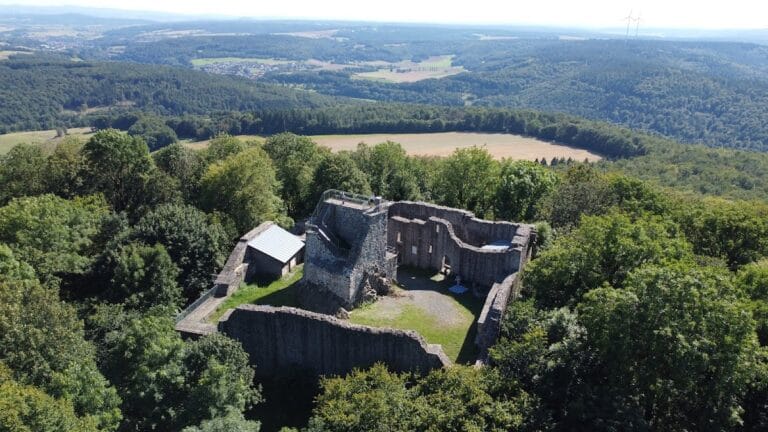
Burg Milnrode occupied a low spur above the Asbach valley, approximately 15 metres above the surrounding ground and about 270 metres above sea level, on the slope of the 397-metre Eschenskuppe in the Knüll Mountains. The castle combined the features of a spur castle and a hill castle. Built largely of rubble stone, the complex extended for about 55 metres from north to south and measured approximately 23 metres across. Its remains include raised foundation walls, earthworks, banks, and defensive ditches within woodland. The meadow below is still called “In der Burg,” while the woodland on the spur north of the ditch retains the name “Burg.”
Layout and defensive works
Neck ditch
A defensive neck ditch cut across the spur on the north side, separating the castle from the higher ground. It extended for about 80 metres, measured approximately 19 metres across at the top, and remained about 5 metres deep. The rectangular upper castle lay south of this ditch. A drawbridge or folding bridge probably led across it to the main entrance on the northern side.
Upper castle
The upper castle measured about 22 metres from north to south and 15 metres from east to west. Its northern side faced the ditch and formed the principal attack-facing side of the stronghold. Square foundations in the northwestern corner are interpreted as the base of a bergfried, the principal fortified tower of a medieval German castle, used mainly for defense and refuge rather than as the main residence. The upper castle also contained a lower southern area separated from the rest by a substantial cross wall.
Lower castle
The lower castle occupied the southern tip of the spur, approximately 3 metres below the upper castle and in front of the residential hall. It formed a roughly triangular area about 18 metres long and 20 metres wide. A second surrounding wall probably enclosed both this lower area and the spur. On the southwestern side, a surviving archaeological section of that wall measured about 19 metres long and 1.38 metres thick. Forestry roads laid out around 1900 damaged parts of this outer wall and may also have affected a ditch along its outer side.
Buildings and masonry
Western building
A building stood along the western side of the upper castle. Its walls were approximately 80 centimetres thick and adjoined a surrounding wall about 1.8 metres thick. Charred wooden beams indicate that the building probably had a timber superstructure resting on a masonry base. Numerous stove tiles found between this building and the principal residential hall suggest that another heated building occupied part of the same area, possibly an earlier and smaller residence.
Principal residential hall
A wall 1.38 metres thick crossed the full width of the slightly lower southern part of the upper castle. It separated a building about 7 metres wide and 15 metres long from the remainder of the complex. Three openings connected this building with the courtyard. Because the cross wall was built after the surrounding wall, the building is interpreted as the palas, the principal residential and ceremonial hall of the castle.
Outer wall and present remains
The southwestern section of the second surrounding wall stood halfway up the spur and formed part of the castle’s outer enclosure. Its masonry is no longer visible above ground, but the site retains the associated earthworks, banks, and ditches. The foundations uncovered during the twentieth-century excavation now appear as masonry raised slightly above the ground surface after the area was reburied in 1988. Together, these marked foundations and surviving earthworks indicate the division between the upper castle, the lower castle, and the defensive perimeter.
Nearby sites