Turnu Fortress: A Medieval Wallachian Stronghold on the Danube
Site at a Glance
- Rating
- 4.2
- Popularity
- Very Low
- Country
- Romania
- Primary era
- Medieval
- External website
- Open
- Eras represented
- Medieval
- Civilizations
- Principality of Wallachia
- Site type
- Military
- Remains
- Fort
On this page9 sections
History
Turnu Fortress is a medieval Wallachian fortress in Romania, in the southern part of Turnu Măgurele. Built during the reign of Mircea the Elder, a Wallachian prince associated with strengthening the principality’s defenses, it belonged to the period of Wallachian resistance to Ottoman expansion along the Danube. The fortress is linked to conflicts of 1394–1395 and appears in a 1397 diploma of King Sigismund of Luxembourg as Nicopolis Minor.
Foundation and the Nicopolis campaigns
In July 1395, a Hungarian expedition led by Sigismund of Luxembourg captured Turnu and installed a garrison. Sigismund was king of Hungary and later Holy Roman Emperor, and he became involved in the Wallachian succession during the 1390s. In 1396, Stibor of Stiboricz, the voivode of Transylvania, and Mircea the Elder defeated Vlad I, recovered the fortress, and crossed the Danube to join the Nicopolis Crusade, the Christian campaign against the Ottoman Empire that ended in defeat at Nicopolis on 25 September.
Turnu probably played an important nearby role in that campaign. The Franco-Wallachian army commanded by Sigismund was defeated by the Ottoman army led by Sultan Bayezid I, who expanded Ottoman power in the Balkans. The expedition bypassed Wallachia because substantial Wallachian and Ottoman forces were stationed around the Nicopolis and Turnu sector. Documents from 1406–1408 also refer to fighting for the fortress.
Ottoman frontier administration
A document from 1404 recounts that Bayezid I invaded Wallachia, forcibly took Nicopolis Minor from Mircea the Elder, and left an Ottoman garrison there. By 1417, near the end of Mircea’s reign, the fortress had become Ottoman. After 1419 it formed the center of the Turnu raya, an Ottoman-administered frontier territory centered on a fortified settlement and supported by surrounding villages. The raya belonged to the Nicopolis sanjak and was subordinate to the pasha of Silistra, a pasha being a high-ranking Ottoman official.
The territory extended roughly 15 kilometers around the fortress and included Flămânda, Măgurele, Odăile, Ciuperceni, Craba, and Gârla. Its garrison watched Wallachia, gathered intelligence, and prepared for military intervention. The surrounding area also supplied the soldiers, supported Ottoman-controlled trade, collected taxes, and stored goods. Wallachian rulers maintained a capuchehaie, or diplomatic representative, at each such administrative center. In the seventeenth century, Turnu was held by a member of the Ottoman sultan’s family. Unlike a military fief, the Wallachian rayas were controlled by senior Ottoman state officials and received support from the Ottoman river fleet.
Wallachian recapture and Ottoman restoration
During Vlad Țepeș’s conflict with the Ottoman Empire, Turnu briefly returned to Romanian control. In the winter of 1461–1462, Vlad’s forces reportedly captured Nicopolis and killed more than 20,000 Ottoman soldiers. When Ottoman troops tried to cross the Danube at the Nicopolis–Turnu sector in early 1462, Wallachian forces on the left bank stopped the crossing. A later Ottoman attack was repulsed, while a Wallachian counterattack was checked by fire from 120 bombards. Vlad then withdrew toward the mountains and forests, harassing the Ottoman army before his surprise attack near Târgoviște on 17 June 1462.
Turnu changed hands again during the Long War, the late-sixteenth- and early-seventeenth-century conflict between the Ottoman Empire and the Habsburg-led Christian powers. Wallachia joined the Holy League, and Michael the Brave attacked Ottoman fortresses on both banks of the Danube. Romanian forces captured Turnu and liberated the surrounding settlements, leaving the fortress under Wallachian command during Michael’s reign. It returned to Ottoman control after Michael’s death at Câmpia Turzii on 9 August 1601.
Destruction and return to Wallachia
By the early nineteenth century, Turnu had become an Ottoman base for incursions into Wallachia. In 1809, Iancu Jianu, an Oltenian hajduk, or outlaw leader associated with armed raids against Ottoman positions, attacked and destroyed the fortress. The assault followed Ottoman actions connected with Osman Pazvantoglu, the pasha who controlled the region around Vidin and conducted military operations against Wallachia, including attacks on Craiova and the burning of villages in Oltenia.
The Treaty of Adrianople, concluded in 1829 after the Russo-Turkish War of 1828–1829, fixed the Ottoman–Wallachian border on the Danube and returned Turnu, along with the Giurgiu and Brăila rayas, to Wallachia. After the transfer, the fortress was burned and demolished. The former raya was incorporated into Wallachia, and its settlements became part of Olt County. Local inhabitants and authorities later reused stone from the ruins as construction material. Turnu Fortress is now included among the historical monuments of Teleorman County, and restoration and structural consolidation have been underway since October 2018 under the responsibility of the municipalities of Turnu Măgurele and Nikopol.
Remains
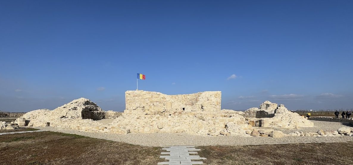
The ruins stand in the southern part of Turnu Măgurele, about 3 kilometers from the city and approximately 1 kilometer from the confluence of the Olt and Danube rivers. The fortress was built in a marshy area. Its plan centered on a circular tower enclosed by a defensive wall, with a ditch surrounding the fortification. The surviving remains are built of stone and are fragmentary, while restoration and structural consolidation have continued since 2018.
Fortification layout
The central tower was surrounded by an enclosure wall at a distance of about 6 meters. The enclosure followed an irregular polygonal plan and measured 4–5 meters in thickness. Massive bastions, projecting defensive platforms, stood along the wall, and an earlier bastioned line was later covered by rebuilding. Three surrounding wall lines are also associated with the fortress, converging toward the south. The defensive ditch was bordered on its inner side by a wall and on its outer side by an escarpment and counter-escarp, the outer slope of a defensive ditch opposite the fortress wall. The inner ditch wall measured 1.5–2 meters thick and included an access area from which a drawbridge descended.
Central tower
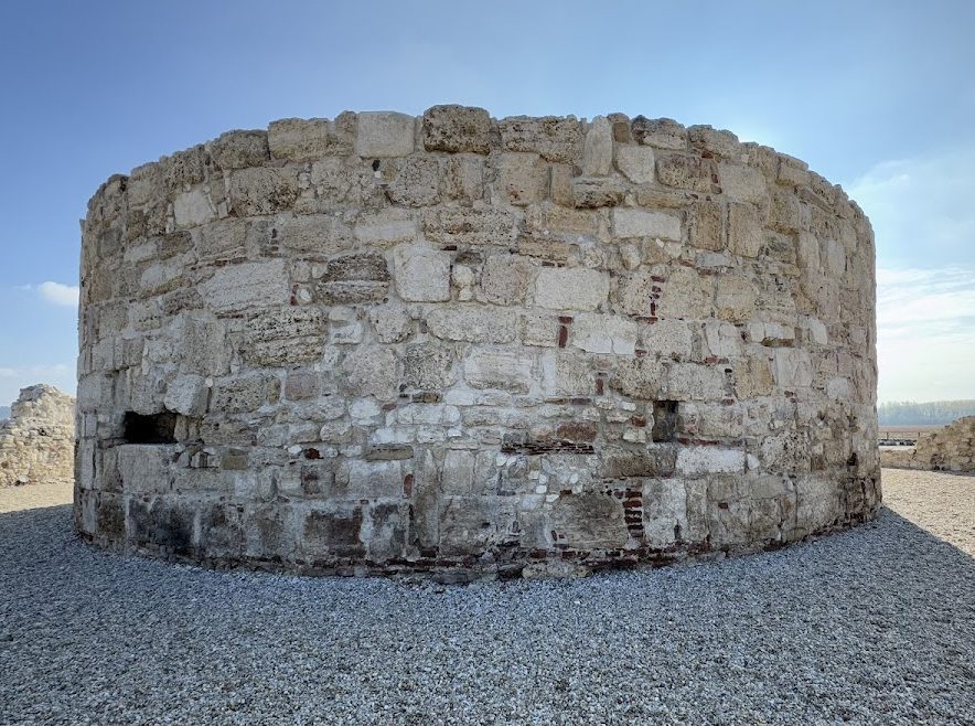
The circular central tower measured 17.40 meters across and had walls about 3 meters thick. It served as a store for ammunition and grain and was roofed with tiles. The first medieval construction phase under Mircea the Elder may have used stone taken from the former Roman camp at Oescus, south of the Danube. The tower’s later interpretation has been shaped by nineteenth-century investigations. August Treboniu Laurian wrote in 1846 that the fortress had been built over the ruins of a Roman tower. Around four decades after the fortress was abandoned, Cezar Bolliac described excavations that exposed the outline of the old tower; he demolished the structure and identified the site as the Roman fortress of Romula. Grigore Florescu later proposed that material from Oescus had been used in the first medieval phase.
Names and archaeological interpretation
Historical records and maps preserve several names for the fortress, including Nicopolis Minor, Kule, Holavnic, Cholonic, and Pirgos. A 1432 document equates the fortress with Pirgos, a Greek word meaning “tower,” although one interpretation places that fortress on the opposite bank of the Danube. Foreign documents generally called Turnu “Little Nicopolis” until the sixteenth century, distinguishing it from Nicopolis across the river. The ruins remain the principal physical evidence of the fortress’s circular tower, polygonal enclosure, bastions, and defensive ditch.