Lichtenberg Castle: A Medieval Welf Fortress in Germany


Site at a Glance
- Rating
- 4.5
- Popularity
- Low
- Country
- Germany
- Primary era
- Medieval
- External website
- Open
- Eras represented
- Medieval, Modern
- Civilizations
- Holy Roman Empire
- Site type
- Military
- Remains
- Castle
On this page11 sections
History
Lichtenberg Castle, also known as Heinrichsburg, is a medieval hill castle in Germany, built by the Welfs near Salzgitter at the beginning of the twelfth century. Its principal expansion probably took place between 1170 and 1180, and the castle was first mentioned in 1180. Duke Henry the Lion, the leading Welf patron associated with the site, developed it as a fortress on the edge of Welf territory, where it confronted the Hildesheim bishopric and the Hohenstaufen-aligned imperial city of Goslar.
Henry the Lion and the imperial conflict
Emperor Frederick I Barbarossa captured Lichtenberg after a short siege in 1180, during his campaign against Henry the Lion. Henry recovered the castle in 1194 after reaching peace with Emperor Henry VI, but died the following year. The fortress then became involved in the continuing rivalry between the Welf and Hohenstaufen dynasties, whose political struggle shaped control of northern German castles during the twelfth and thirteenth centuries.
Otto IV, Henry’s son and a Welf claimant to the German kingship during the succession conflict of 1198, used Lichtenberg’s position against Goslar. In 1204 he held a lavish court assembly at the castle. The event is commemorated by a coin carrying the inscription “MONETA REGIS OTTONIS IN LEGT(ENBERG),” meaning the money of King Otto at Lichtenberg.
In 1206, Hohenstaufen forces sent Count Hermann von Wöltingerode, the reeve of Goslar, to take the fortress. Hermann captured Lichtenberg and used it as a base for raids into nearby territories, including the region around Peine. Count Gunzelin of Wolfenbüttel attempted to recover the castle in early June, but his siege failed. After Otto IV was recognized as sole king in 1208, Lichtenberg returned to the Welfs.
Decline as a military stronghold
After Otto IV’s death in 1218, the castle passed to Otto the Child, Duke of Brunswick and Lüneburg, and later to his son, Duke John of Brunswick and Lüneburg. Its military importance diminished after the Welfs and Hohenstaufens reconciled in 1235. Lichtenberg was later pledged to the city of Brunswick. The Lords of Saldern redeemed it in 1365 and used it as a base for raids, activities entered in the Brunswick Feud Book for 1379 to 1382.
In 1388 the castle came under the Principality of Brunswick, and the Saldern family was expelled during the fifteenth century. Documents from this period name Rudolf von Garßenbüttel and Herwig von Uetze as reeves. During the Hildesheim Diocesan Feud, a conflict fought from 1519 to 1523, the Lords of Saldern again defended Lichtenberg as a pledged holding on behalf of Duke Henry the Younger of Brunswick-Wolfenbüttel. Once Hildesheim came under Welf control, the castle no longer served as a defensive position against that territory.
Capture, ruin, and archaeological investigation
On 22 October 1552, troops commanded by Count Vollrad von Mansfeld of the Schmalkaldic League reached the castle. This alliance of Protestant German princes and cities was fighting the imperial forces of Charles V. Mansfeld’s army included about 5,400 mercenary infantry and 2,100 cavalry. From 29 October, large-calibre Fürmösers bombarded Lichtenberg. The attackers captured the castle after eight days, and it has remained a ruin since the assault. Later, its masonry was quarried for the construction of the Lichtenberg estate.
Interest in the ruins revived during the nineteenth century, when historical awareness and nationalist ideas grew after the foundation of the German Empire in 1871. A castle beautification association was founded in 1892 and re-established in 1995 as the Friends of Lichtenberg Castle. Archaeological excavations began in 1893, continued in the late 1950s, and resumed from 2004. They exposed the foundations of the stone buildings, including a gate complex attributed to the period of Henry the Lion that was uncovered in 2004. Earlier investigations had identified remains dating mainly from the fourteenth to sixteenth centuries.
Finds from later excavations are displayed in the permanent exhibition of the Municipal Museum at Salder Castle. They include a fragment of a hook gun engraved with coats of arms associated with the Cramm family. The weapon may have belonged to Burchard von Cramm or to his cousin Asche von Cramm, who took opposing sides in the Hildesheim Diocesan Feud. A second emblem may resemble the arms of the von Hoym family, which was related to Asche through his mother. A reconstructed medieval stone-throwing machine was installed among the ruins in 2005. A wooden viewing platform on the reconstructed tower was destroyed by fire in 2016 and replaced in 2019.
Remains
Castle layout and upper fortress
The ruins occupy the steep summit of the Burgberg at an elevation of 241 metres, south of and above Salzgitter-Lichtenberg in the Lichten Hills. The complex consists of an upper main castle and a lower outer bailey. The upper castle sits on an oval plateau measuring about 45 by 80 metres and was enclosed by a ring wall approximately 1.6 metres thick. The entire complex extends for roughly 200 by 120 metres within a system of ramparts, ditches, and a ring wall with thirteen open semicircular towers.
Keep and reconstructed tower
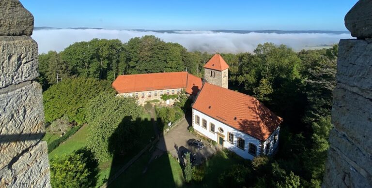
The keep stood separately at the highest point of the upper castle. Its circular foundation measures 10 metres across and is 2.5 metres thick, while the masonry above ground had a hexagonal plan. The decayed masonry stump, still about 15 metres high, collapsed in 1861 and was demolished. In 1892 and 1893, the castle association erected a new hexagonal tower on the old foundations. The replacement tower is approximately 25 metres high and carries a viewing platform.
Kemenate and service buildings
Near the keep is the Kemenate, a medieval residential stone building measuring 12 by 12 metres, with walls 1.6 metres thick. It contained a warm-air heating system fired from outside through a workroom, although the installation may have been added later. The building was rebuilt in 1957, and its present form incorporates the original fabric while differing in some respects from the excavation plans. A later structure attached to its southern side has been interpreted as a bakery.
Palas and castle well
Slightly below the central castle is a building measuring about 32 by 8 metres, identified as a palas, the principal residential or representative building of a medieval castle. It stands beside a tower and dungeon. A well occupies the centre of the upper castle. Excavated by hand, it is approximately 60 metres deep and 3 metres in diameter. Earlier buildings survive mainly as isolated foundation fragments, while fourteenth-century service buildings and a possible chapel are represented within the upper castle.
Outer defenses and internal circulation
The western and southern sides of the core castle are protected by a crescent-shaped neck ditch and an outer rampart. The lower outer bailey was constructed in the fourteenth century and surrounded the core castle on all sides. Parts of the gate walls and their associated ditch survive. A path from the southwestern outer gate once led clockwise around the core castle toward its entrance, while a barrier wall blocked the direct route.
Excavated paving preserves wheel ruts made by carts. In a room measuring about 10 by 8.5 metres, excavators found a hypocaust-type heating system. A hypocaust warms a room by circulating heated air beneath or within the floor. Here, a fire burned in a walled cellar, heating stones and the air inside the masonry. Nine closable openings regulated the airflow, and a separate chimney carried away smoke.
Archaeological finds and later structures
A thirteenth-century gold finger ring recovered during archaeological work contains an antique gem showing Europa on the Bull. The ring and the fragment of the sixteenth-century hook gun are displayed at the Municipal Museum in Salder Castle. The Burghotel, an excursion restaurant, occupies part of the outer-bailey area.
Above the castle ruins stands the Gaußstein, a surveying pillar erected around 1820 at Carl Friedrich Gauss’s Lichtenberg station. Gauss, a German mathematician and geodesist, used elevated stations and sightlines for a triangulation survey of the Kingdom of Hanover commissioned by King George IV. The pillar occupies the elevated centre of a medieval motte, a raised earthen mound that supported a fortified structure. The station was aligned with the Brocken, Hils, Deister, Falkenberg, and Garssen stations, and a twentieth-century commemorative plaque was supplied by the Gebrüder Schreitel firm.