Phaselis Ancient City: A Greek Port and Roman City in Türkiye


Site at a Glance
- Rating
- 4.7
- Popularity
- High
- Country
- Turkey
- Primary era
- Classical
- External website
- Open
- Eras represented
- Classical, Medieval
- Civilizations
- Ancient Greek, Byzantine, Roman
- Site type
- City
On this page30 sections
History
Phaselis Ancient City is a Greek-founded settlement in Türkiye, near Kemer on the Antalya coast. Colonists from Rhodes led by Lakios established it around 700 BC, or possibly about 695 BC, as a Greek city-state on the boundary of Lycia and Pamphylia. Built beside three sheltered harbours during the Archaic period, Phaselis served shipping along the difficult southern Anatolian coast and became a port linking Greece, Asia Minor, Egypt, Phoenicia, Cyprus, and inland communities.
A maritime city between empires
Phaselis occupied a narrow peninsula between the mountains and the Mediterranean. Its natural defences, freshwater resources, and protected anchorages supported a community whose economy depended mainly on seafaring and maritime trade. Agriculture had a secondary role because the surrounding landscape was rocky and marshy, although the city controlled a rural territory that included at least two dependent villages. Sheep raising and the probable export of timber from nearby forests also contributed to its economy. The name Phaselis may derive from a Luwian expression meaning “seaside town.”
During the sixth century BC, the city came under the Lydian Kingdom and then the Achaemenid Empire, the Persian imperial state that ruled much of Anatolia and the eastern Mediterranean. In the 460s BC, during the Greek-Persian Wars, an Athenian fleet commanded by Cimon captured Phaselis. The city later joined the Delian Confederacy, an alliance of Greek states led by Athens, and appears on the confederacy’s membership list for 453 BC. It entered the Athenian sphere of influence under the Peace of Callias, a diplomatic settlement associated with the end of major hostilities between Athens and the Achaemenid Empire.
Sparta controlled Phaselis for part of the Peloponnesian War, the conflict between Athens and Sparta and their respective allies. A Spartan garrison was stationed there in 411 BC. By the late fifth or early fourth century BC, Phaselis had resumed issuing its own coinage, probably reflecting the end of direct Spartan and Athenian control. The city may then have returned to Achaemenid authority.
Alexander and the Hellenistic kingdoms
In spring 334 BC, Phaselis voluntarily submitted to Alexander the Great. Its envoys met the Macedonian army before it reached the city and presented Alexander with a golden crown. Alexander and his companions stayed at Phaselis for several days. At the inhabitants’ request, he campaigned against a Pisidian group that had been attacking the city’s rural territory.
During his stay, Alexander and his companions crowned a statue of Theodectes, a rhetorician and tragic poet associated with Phaselis. The ceremony recalled that Alexander and Theodectes had both been pupils of Aristotle. After Alexander’s death in 323 BC, Phaselis entered the extensive satrapy, or administrative province, of Antigonus I Monophthalmus. In the Hellenistic period, the city successively came under the influence or control of Ptolemaic Egypt, Rhodes, and, briefly, the Seleucids.
Ptolemy I captured Phaselis in 309 BC and used it as a strategic naval base for controlling the coastal trade route. The city remained allied with the Ptolemies even after their direct authority weakened. Following the Treaty of Apamea in 188 BC, Phaselis was transferred to the Rhodian state and remained under Rhodian hegemony for roughly two decades. In 167 BC it joined the Lycian League, a federation whose member cities retained local institutions while participating in a wider political and military association.
By about 160 BC, Phaselis had resumed its traditional ship-themed coinage and was again formally independent, although Roman influence was increasing. In the late second or first century BC, the city became involved in Rome’s regional system. Around 78 BC, Publius Servilius Vatia Isauricus defeated the pirate leader Zekenites and captured Phaselis, which had been under pirate control. Rome took part of the city’s territory for the Roman people. In 42 BC, Brutus formally linked Phaselis to Rome.
Roman prosperity and administration
The first century BC and first century AD brought Phaselis into the Roman administrative system while preserving considerable municipal autonomy. The city retained elected magistrates and local taxation. In AD 43 it was placed in the province of Lycia. Under Vespasian, Lycia, Pamphylia, and Pisidia were combined into the province of Lycia-Pamphylia, centred at Perge. After the reforms of Diocletian and Constantine, Phaselis belonged to the province of Lycia.
Roman rule was the city’s principal period of prosperity and territorial expansion. Most of the substantial urban monuments visible today were built during this era, while Phaselis continued to operate as a commercial port. Piracy again threatened the harbours during the third century AD. Economic and political difficulties in the third and fourth centuries probably reduced the city’s population and territory. The baths and aqueduct ceased to function in the fourth century, apparently because their upkeep had become too costly, and the port installations also declined.
Christian and Byzantine Phaselis
Christianity spread in Phaselis from the fourth century onward and was probably established by the fifth century. The city became a Christian bishopric subordinate to the metropolitan see of Myra. Bishop Fronto took part in the Council of Chalcedon in 451. Aristodemus was among the Lycian bishops who signed a letter to Emperor Leo I in 458, and Phaselis was represented at the Second Council of Nicaea in 787 by a deacon signing for its bishop.
The fifth and sixth centuries brought a final period of prosperity. Major public buildings and harbour facilities were repaired, but the city’s fortunes changed during the seventh century. The Arab-Byzantine wars made Pamphylia a frontier zone, and Phaselis probably suffered attacks and destruction by Arab forces. It may later have served for a time as a Byzantine naval base.
In the late seventh or early eighth century, Phaselis probably became part of the Byzantine naval theme of the Cibyrrhaeots, a military-administrative district responsible chiefly for maritime defence along the southwestern Anatolian coast. The inhabited area contracted sharply and became largely confined to the fortified acropolis. Rebuilt and occupied in reduced form, the acropolis remained in use for approximately another century and a half.
References to Phaselis become scarce after the tenth century, although activity may have continued until the Seljuq conquest in the early thirteenth century. Other accounts place Seljuq attacks in 1158 and describe the city as impoverished by the eleventh century. Earthquakes, piracy, the growth of Antalya and Alanya as ports, marsh formation, disease, and the decline of maritime commerce all contributed to Phaselis’s loss of importance.
Excavation and preservation
A German archaeological expedition worked at Phaselis during the 1980s and clarified several aspects of the city’s development. Finds from the excavations were divided between the Archaeological Museum of Antalya and a small museum at Phaselis. The ruins lie within Olympos National Park, also known as Beydaglari Coastal National Park, north of modern Tekirova in Antalya Province. Their geographical isolation helped preserve them better than the remains of many other Lycian and Pamphylian cities.
Remains
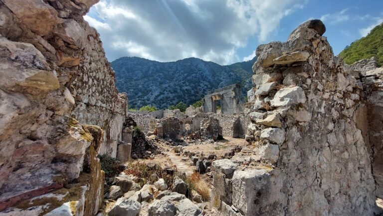
Phaselis occupies a small peninsula projecting into the Mediterranean. The acropolis stands on a steep rocky hill at the peninsula’s head, with a northern harbour, a central city harbour, and a southern harbour around it. Later urban growth spread across the lowland between the acropolis, the harbours, and a freshwater lake. The lake described by Strabo has become shallow and almost entirely changed into marshland, but its position helped provide freshwater and a natural defensive barrier. The Classical and Hellenistic city expanded into the lowland between the lake and the western harbour, known in modern scholarship as Weststadt, and onto the plateau northeast of the city called Nordsiedlung.
Main street and public squares
Main street
The principal excavated street ran between the city harbour and the southern harbour. A small square divided it into two sections and connected with the Square Agora, the Great and Small Baths, and the theatre. Shops and workshops lined the route, which was furnished with porticoes and statues. Many of the surviving sculptural remains are statue bases.
Agoras
Three agoras were built along the main street during the Hellenistic and Roman periods. Each was a public courtyard surrounded by porticoes, with shops and workshops opening onto the space. Monumental entrance gateways connected the agoras with the streets. The three complexes were built or rebuilt during the first and second centuries AD.
Square Agora
The Square Agora had an approximately square plan and opened onto the small square in the main street. Its outer walls were constructed from large, carefully dressed limestone blocks in a technique associated with the early Roman period, probably during the first century AD. The complex replaced an earlier Hellenistic structure and probably retained its commercial function until the fourth century. A three-aisled Christian basilica, a rectangular church divided lengthwise into aisles, was later inserted into its eastern part, while the remaining area probably served as the church’s atrium.
Domitian Agora
The Domitian Agora stood directly against the southern wall of the Square Agora. Probably built in the first century AD, it was the largest of Phaselis’s three agoras, measuring nearly twice the size of the Square and Harbour Agoras. A partly preserved Greek dedication to Emperor Domitian survives above its principal gate. Repairs in the fifth or sixth century used rubble and broken brick over earlier dressed stonework.
Harbour Agora
The Harbour Agora lay south of the Domitian Agora and opened towards the waterfront of the southern harbour. Its irregular quadrilateral plan made it nearly half the size of the Domitian Agora. Probably constructed in the second century AD, it was largely destroyed in the third or fourth century and rebuilt on its remains during the fifth or sixth century. The lower courses use dressed limestone blocks, while the upper courses are made from rubble and broken brick.
Theatre and bath complexes
Theatre
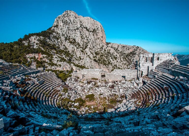
The theatre stood on the western slope of the acropolis above the small square in the main street. Its surviving auditorium is Roman in form and probably dates from the first or second century AD, although it replaced an earlier theatre whose date remains uncertain. Estimates place its capacity at approximately 1,500 to 3,000 spectators.
The auditorium was built against the hillside and contained about 20 or 21 rows of seats. Three passageways divided them into five sections, while a horizontal passage ran above the upper rows. The orchestra had the semicircular shape characteristic of Roman theatres. The modest stage building is poorly preserved and lacked a proskenion, a formal stage front. Two side entrances admitted spectators, probably by stairways from the street, which lay about 10 metres below them.
In the late Roman period, the theatre may have been used as an arena. During the early Byzantine period, its stage building was rebuilt and incorporated into the acropolis fortifications. The auditorium is now badly preserved, with trees and shrubs growing among the seats.
Great Baths
The Great Baths stood beside the northern wall of the Square Agora on the main street. Their irregular plan resulted from the restricted building plot, and the complex’s axis differed substantially from that of the street. A porticoed atrium with a mosaic floor led into the principal rooms, which extended along a north-south axis.
The bathing sequence included a large frigidarium for cold bathing, followed by elongated rooms identified as a tepidarium for warm bathing and a caldarium for hot bathing. Heavy cylindrical vaults covered the rooms, and a partly preserved hypocaust, an underfloor heating system that circulated hot air beneath the floor, warmed the complex. Carefully dressed rectangular limestone blocks formed the walls, while brick and rough stone were used mainly for the heating supports and vaults. The baths probably date from the second century AD.
Small Baths
The Small Baths stood opposite the Great Baths on the other side of the main street, beneath the theatre. Also built in the second century AD, they contained an apodyterium, or changing room, followed by a frigidarium, tepidarium, and caldarium. Their walls were made from carefully dressed limestone blocks and survive to the level of the vaults.
Aqueduct
The aqueduct was built in the second century AD principally to supply the central baths. Its narrow channel had limited capacity. Beginning on a plateau near the city, it extended for less than 1.5 kilometres. Most of its route used pipes, while the final approximately 200 metres ran along a single-tier arcade of dressed stone. It probably remained in use from the second through the sixth century.
Harbours and fortifications
Harbours
The three harbours shaped the city’s urban form and maritime function. The northern, central, and southern harbours occupied the sheltered sides of the peninsula, while sea walls survive around the city harbour. The Harbour Agora opened towards the southern waterfront, and the principal street connected the city’s commercial and public areas with both the central and southern harbours.
City and acropolis walls
Phaselis’s fortifications developed in stages as the settlement expanded and contracted. They relied heavily on the peninsula’s natural defences, and surviving walls are fragmentary. Several periods of construction appear along the western slope of the acropolis. Fortifications may have existed there from the seventh century BC, while the earliest surviving sections date from the third century BC.
The acropolis walls were probably little used during the Hellenistic and Roman periods and may have been partly dismantled. When settlement contracted to the acropolis in the seventh or eighth century, a new wall followed the hillside. It reused earlier Hellenistic walls and other structures, including the theatre’s stage building, and was reinforced with square-plan towers. Further defensive remains survive beside the lake and along part of the route between the lake and the southern-harbour waterfront in Weststadt. These walls appear to have lacked towers.
Hadrian’s Arch
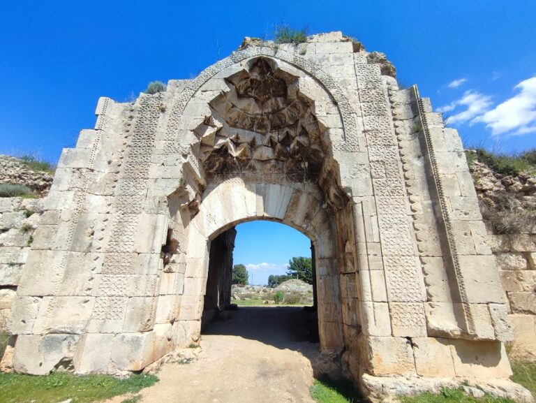
A triumphal arch was erected at the southern end of the main street in the second century AD, where the street reached the southern harbour. An excavation dedication to Emperor Hadrian gave the monument its modern name. The relatively small, richly carved arch had a single opening between paired piers. Only their stylobates, or supporting base courses, survive, while a large Greek dedication to Hadrian ran along the cornice.
Religious buildings
Possible temple complexes
Written sources associate Phaselis with temples dedicated to Athena and Hermes. Two archaeological complexes have been proposed as possible temple remains. One lies west of the Square Agora in the city centre. The larger complex stands at the foot of the Nordsiedlung plateau and survives mainly as a substantial stone platform. Its masonry suggests a Hellenistic, or more probably Roman, date. Its size could suit a principal temple dedicated to Athena, although its peripheral position leaves that interpretation uncertain.
The temple of Athena was associated with the exhibition of Achilles’ spear. Phaselis was also linked to a later tradition that a golden sarcophagus containing Alexander the Great’s ashes was kept there during the late Roman period. This tradition concerns the city’s historical memory rather than a surviving feature of the ruins.
Basilica in the Square Agora
A small three-aisled Christian basilica was inserted into the eastern part of the Square Agora, probably during the fifth or sixth century. Built mainly from rough stone with a small quantity of brick, it had one semicircular apse and probably no women’s gallery. The part of the agora outside the church probably served as its atrium.
Acropolis church
A second, probably later church stood in the southern part of the acropolis. Its shortened basilican plan included a small square room attached on the north, possibly for a stair tower and upper gallery. The church probably dates from the seventh or eighth century and served the reduced settlement centred on the fortified acropolis.
Necropolis and tombs
Necropolis
The necropolis lay west of the northern harbour, between the coast and the Nordsiedlung plateau. Individual sarcophagi and large enclosed tombs occupied the cemetery. Some sarcophagus lids were decorated with figures of Erotes and lions, and numerous sarcophagi remain at the site.
Mausolea
Three mausolea are especially notable. The southern example, near the line of the aqueduct, was probably Roman and had two or three levels. Its lowest level opened directly towards the shore, with one room on each level. Two northern mausolea were single-storey buildings with one rectangular interior room and an external open portico. Their walls used rough stone, broken brick, and reused large limestone blocks. Timber-framed roofs indicate an early Byzantine date, probably between the sixth and eighth centuries.
Economic remains and collections
Phaselis was known for producing rose essence, an association reflected in descriptions of the city’s rose products. The surviving ruins also preserve the physical evidence of its commercial life through the agoras, shops, workshops, harbour connections, and porticoes along the main street. Many substantial structures remain buried and await further investigation. Excavated objects are preserved partly in the Archaeological Museum of Antalya and partly in the small museum at Phaselis.