Inglinge hög: A Prehistoric Burial Mound in Sweden
Site at a Glance
- Popularity
- Medium
- Country
- Sweden
- Primary era
- Iron Age
- Eras represented
- Bronze Age, Iron Age
- Civilizations
- Unclassified
- Site type
- Burial
- Remains
- Necropolis
On this page20 sections
History
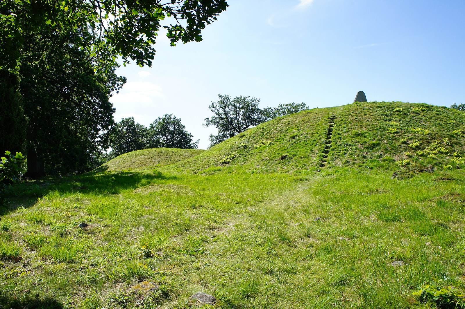
Inglinge hög is a prehistoric burial mound within a gravefield west of Ingelstad in Småland, Sweden. The cemetery is associated with the Iron Age, but the mound itself has been dated variously to the Bronze Age and Iron Age. The surrounding gravefield is also considered the oldest assembly site in southern Småland. Assembly sites could serve judicial or administrative purposes.
Dating and historical setting
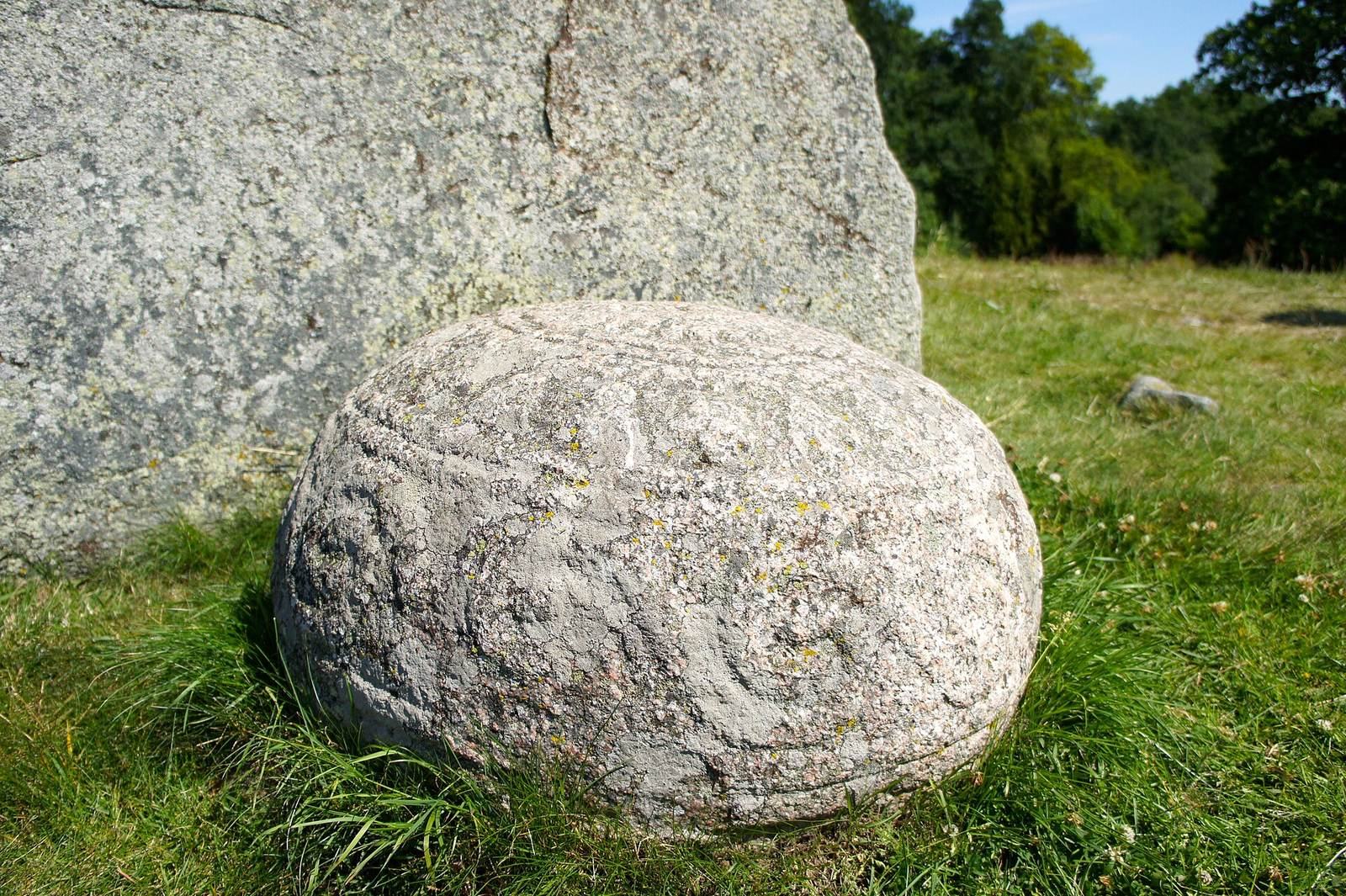
Archaeologists have disagreed about when the mound was raised. Birger Nerman argued for a Bronze Age date, drawing on the decoration of the stone sphere beside the mound’s summit and finds attributed to an earlier excavation. Erik Floderus favored an Iron Age date, citing the mound’s shape, the association of decorated stone spheres with Iron Age graves, and similarities between the sphere’s decoration and images on Gotland picture stones.
The gravefield’s large ship-shaped stone settings have also informed the debate. Knut Kjellmark noted that comparable settings on Gotland have been dated to either the Bronze Age or early Iron Age. The settings at Inglinge hög may also date to the early Iron Age; on that assumption, they have been used to support a proposed date for the mound in the Migration Period, an early phase of the Iron Age. These separate dates do not settle the question of when the mound was built.
The name Inglinge hög has prompted suggestions of a link to the Yngling dynasty, a traditional early Scandinavian royal lineage known from Norse tradition, or to a local king named Inge. Neither connection is established.
The eighteenth-century digging
A digging episode associated with the mound is dated to 1774 in an account by the travel writer Linnerhielm. He described Schenberg, a municipal councillor from Skänninge, digging down to the mound’s base. The mound was reportedly refilled more than ten years later, but some of the excavated earth was not returned. Its height was said to have fallen by one to one and a half ells, a traditional unit of length, and its former pointed shape and surface were altered. Floderus considered either 1774 or 1782 a possible date for the digging.
Sune Lindqvist and Floderus initially suggested that the digging might have involved the large mound beside Inglinge hög instead. Nerman rejected that explanation, and Floderus later accepted that Inglinge hög had been plundered. He nevertheless considered it unlikely that the diggers reached the central grave, suggesting that they may instead have disturbed a secondary burial. Nerman interpreted the finds attributed to the digging as consistent with Bronze Age burials, possibly from two separate graves; Floderus maintained an Iron Age date for the mound and considered a secondary burial a more likely explanation.
Investigations and later burials
Investigations at the gravefield took place in the mid-nineteenth century, and Erik Floderus excavated several graves during restoration work in 1931. The excavated burials show that the cemetery was used across a long span of time. One grave examined in 1931 is considered probably late Viking Age; its sparse grave goods have been linked to the influence of Christianity.
Remains
Layout of the gravefield
The gravefield contains about 130 prehistoric features. These include five mounds, approximately 96 oval stone settings, ten round settings, eight rectangular settings, five irregular settings, two ship-shaped settings, and three isolated standing stones. Some of the oval settings may also be ship-shaped. The cemetery once extended farther east, where remains may still survive underground.
Mounds
Inglinge hög
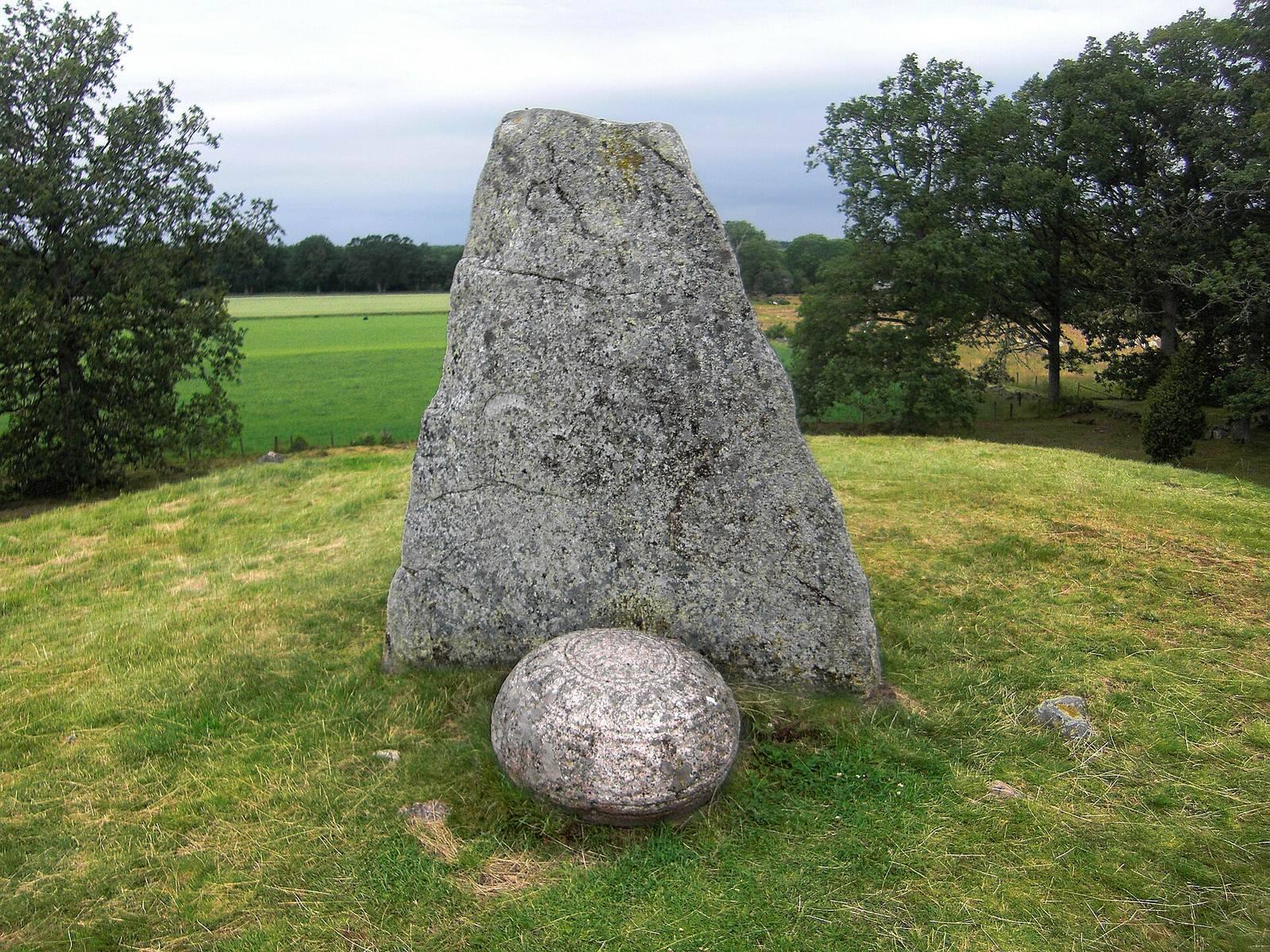
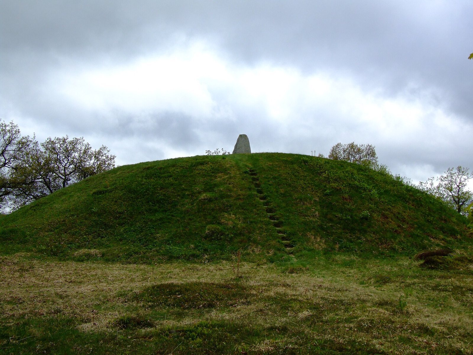
The main mound is about 37 metres across and 6 metres high. Its summit is nearly flat and measures 9 to 11 metres across. Stones visible on the mound’s surface are generally 0.15 to 0.3 metres across, with some reaching 0.5 metres. At the summit’s centre stands an ornamented stone, 1.9 metres high, 1.8 metres wide from north to south, and 0.2 metres thick. It leans slightly south and bears decoration in shallow relief. Beside it on the south is an ornamented stone sphere associated with a burial, sometimes described as a grave sphere. The sphere measures up to 0.78 metres across and 0.57 metres at its narrowest point.
The southern mound
A second large mound immediately south of the main one is 28 metres across and about 3.25 metres high. Its surface stones measure 0.2 to 0.6 metres across. The centre has been disturbed and includes a pit 3.5 metres across and about 1.5 metres deep, a semicircular ditch 1 metre wide and 1 to 1.5 metres deep, and an uneven platform measuring 3 by 4 metres and reaching 1 metre deep.
The smaller mounds
The other three mounds measure 8 to 10 metres across and 1 to 1.2 metres high. One has a standing stone at its centre, measuring 0.7 by 0.45 by 0.35 metres.
Stone settings and standing stones
Ship-shaped settings
The two ship-shaped settings are 15 and 21 metres long, each 10 metres wide. Their outlines are formed by stones 1 to 1.7 metres long and 0.3 to 1 metre high. The gaps between the boundary stones measure 0.3 to 1.5 metres in one setting and 1.5 to 2 metres in the other. One setting has a blunt south end, perhaps because it was shortened to make room for Inglinge hög. The other lies immediately north of the mound and may also have been shortened when the mound was built. The western setting lies west of the main mound. A smaller, filled round setting sits within and beside the western edge of one ship-shaped feature; it is 3.5 metres across and 0.5 metres high, with a turf-covered surface, visible stones 0.3 to 0.6 metres across, and a border of similarly sized stones.
Round settings
The round settings are 4 to 7 metres across and 0.3 to 0.4 metres high, and are covered with turf. Some have surface stones 0.2 to 0.3 metres across; others have borders formed from stones 0.5 to 1 metre across. One includes a standing stone 1.85 metres high, 1.5 metres wide, and 0.54 metres thick. Stones measuring 0.3 to 0.6 metres across provide most of its support.
Rectangular settings
The rectangular settings measure 3 to 6 metres long and 2 to 4 metres wide. They are filled with stones and rise about 0.3 metres. Their border stones generally measure 0.3 to 0.5 metres across.
Oval settings
The oval settings are 3 to 8 metres long and 1.5 to 4 metres wide, with border stones measuring 0.3 to 1 metre across. One has a standing stone at its north end, 1.75 metres high, 0.65 metres wide, and 0.42 metres thick.
Irregular settings and isolated stones
The five irregular settings are about 4 metres long and 3.5 to 4 metres wide. Their border stones measure 0.3 to 0.5 metres across. The three isolated standing stones include one 1.45 metres high, 0.5 metres wide, and 0.35 metres thick. The others are about 0.6 metres high, 0.4 metres wide, and 0.2 to 0.3 metres thick. All three have fallen toward the north.
Excavated graves and finds
The small cairn
Grave 40 is a small cairn, a mound made of loose stones, identified as the gravefield’s oldest grave. It contained a bronze dagger dated to 1400 BC.
The grave north of the main mound
A grave north of Inglinge hög, excavated in 1931, contained the cremated remains of a woman and grave goods dated to AD 750. The remains of the funeral pyre had been arranged in the form of a small house. Glass beads and finely made bronze ornaments were also found there.
Other grave finds
Grave 109 is a small ship-shaped setting beside the roadside. Excavators found cremated bones placed in the grave after cremation at an unknown location, along with an unidentified iron object and little other grave material. Viking Age oval brooches have been found in excavated graves elsewhere in the cemetery.
A double-edged sword and an urn containing ash were attributed to the eighteenth-century digging at Inglinge hög. The sword was described as placed point-down. Their connection to the mound, and whether the diggers reached its central grave, remains disputed.