Vyr: A Medieval Rus Frontier City in Ukraine
Site at a Glance
- Popularity
- Medium
- Country
- Ukraine
- Primary era
- Medieval
- Eras represented
- Medieval
- Civilizations
- Kievan Rus
- Site type
- City
On this page8 sections
History
Foundation and princely conflict
Vyr was a medieval city of Rus, the East Slavic political world, at the site now occupied by Bilopillia in Ukraine. Its foundation is dated to 1113, the year it first appears in the Ipatiev Chronicle. The city is also mentioned in Vladimir Monomakh’s Instruction, a work of advice for princes. Other recorded forms of its name include Vir and Vyrev.
In 1113, during a conflict involving Izyaslav Mstislavich, grand prince of Kiev, and the Davydovichi and Olgovichi princely lineages, the Olgovichi besieged Vyr. The inhabitants remained loyal to the Kievan prince, and the besieging forces withdrew.
Changing rule and destruction
Chronicles mention Vyr again in 1147, 1160, and 1161, amid clashes with the Polovtsians, also known as Cumans, a Turkic nomadic confederation, and disputes among princes in the southern lands of Rus. Vyr was the center of an administrative territory between the upper reaches of the Sula and Seym rivers, covering more than 8,000 square kilometres. Control of the city changed hands several times during the 12th century. From 1159 to 1162, it was the capital of Izyaslav Davydovych’s princely domain; later, it belonged to the Novgorod-Seversk Principality along with the Kursk Seim region.
Vyr helped defend Rus’s southeastern border by controlling a passage into the Polovtsian steppe. It was destroyed in 1239 during the Mongol-led invasion of the lands of Rus. The city may also correspond to a place named by al-Idrisi, a 12th-century Arab geographer and cartographer.
Frontier use and archaeological study
In the 16th century, Vyr’s old citadel, or fortified inner settlement, served as an outpost for the Putivl frontier guard of the Principality of Moscow, a territory ruled by a prince. Its earthworks and the surrounding terrain supported this defensive role, with a crossing of the Vyr River nearby.
Filaret (Gumilevsky), a 19th-century historian and theologian, located the site in the mid-19th century. Archaeologists V. A. Bogusevich and V. V. Pryimak investigated it in 1958–1959 and 1985–1993; excavations across the site covered about 800 square metres. Vyr is protected in Ukraine as an immovable monument of national significance.
Remains
Settlement layout
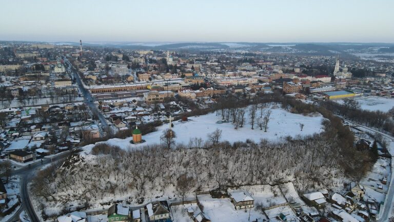
The archaeological site lies on the left bank of the Vyr River, where the Kryha tributary joins it. The Vyr flows onward to the Seym, within the Dnipro basin. The settlement had a fortified central area, an outer fortified town, and an adjoining open settlement.
Citadel and surrounding settlement
The citadel covered 1.5 hectares on a high promontory on the left bank of the Kryha, rising 15–18 metres. Beyond it stood the outer fortified town, while the adjacent open settlement extended across 7–10 hectares. Modern Bilopillia occupies the archaeological site.
Buildings and craft activity
Excavations revealed residential buildings and structures used for production and household activities. Finds also indicate ironworking, blacksmithing, jewellery-making, and bone-carving at Vyr.