City Wall of Visby: Medieval Defenses of a Hanseatic Town
Site at a Glance
- Popularity
- High
- Country
- Sweden
- Primary era
- Medieval
- Eras represented
- Medieval, Early Modern, Modern
- Civilizations
- Crusader, Danish, Swedish, Teutonic Order
- Site type
- Military
- Remains
- Wall
On this page33 sections
History
The City Wall of Visby is a medieval defensive circuit enclosing Visby on the Swedish island of Gotland. Built chiefly in the 13th and 14th centuries, it reflects the town’s commercial importance and forms part of the Hanseatic Town of Visby, added to the UNESCO World Heritage List in 1995 under criteria recognizing historic architectural ensembles and traditional settlements vulnerable to change.
Harbor defenses and the first walls
The oldest surviving part of the circuit is Kruttornet, built in 1160–1161 as a separate defense at the northern entrance to Visby’s medieval harbor. Its construction was associated with the conclusion of a trade agreement with the Duke of Saxony. A matching tower once guarded the harbor’s southern entrance.
The wall along the sea appears to have preceded the defenses on the landward side. It was probably built around 1250 between the harbor towers. A blocked double gate between Kruttornet and Lilla Strandporten may have served as a toll passage through this earlier wall.
The landward circuit and conflict in 1288
Work on a more complete defense on the landward side began in the 1270s and 1280s. Tree-ring analysis places the construction of Österport no earlier than 1286, Norderport around 1289, and Snäckgärdsporten in 1294. About twenty large towers were added between gates during the 1290s and early 1300s.
The new defenses were probably connected to conflict between Visby and the Gotland assembly, a regional institution involved in the island’s affairs. Their tensions led to civil war in 1288. A ruined section east of Kvarntornet may date to the opening of the conflict, when Visby was captured and plundered. Fortified town walls were unusual in medieval Scandinavia: only Stockholm, Kalmar, and Visby had them in medieval Sweden.
Rebuilding, conquest, and attack
The last major medieval rebuilding took place in the 1350s. The wall was strengthened and raised, and around twenty small towers were placed along its eastern section. In 1361, after taking Visby, Valdemar IV of Denmark ordered part of the wall demolished as a sign of submission. The damaged section was rebuilt in 1363.
The Teutonic Order, a medieval religious and military order, controlled Gotland from 1398 to 1408. Silverhättan probably dates to this period, as may two smaller towers facing the sea. Kruttornet was used intermittently to store gunpowder during the 1361 war and again between 1394 and 1487, when Visby’s representatives sometimes changed allegiance.
Lübeck’s attack on Visby in 1525 was the town’s last major assault. The place traditionally identified as the breach used by the attackers, Lübeckerbräschen, probably collapsed later, although it may mark a location where Lübeck’s forces damaged the defenses. During the attack, much of the town burned, and churches and monasteries were looted; many were never rebuilt.
Changing uses and later defenses
By the 16th century, the wall’s military purpose had largely ended. Two projecting gun platforms, called caponiers, were added to the eastern wall, while the circuit chiefly served as a customs barrier. Swedish domestic tolls ended in 1810. The wall was already a familiar landmark, a circumstance credited with helping preserve it.
In the early 18th century, fears of a Russian attack following devastation along Gotland’s east coast prompted the arming of parts of the wall, towers, and gates. Governor and major general Anders Sparfeldt oversaw this work. Elsewhere, the defenses continued to be adapted for non-military purposes, including storage and a military testing ground.
Architect Emil Victor Langlet directed restoration from 1884 to 1886. A ten-metre stretch of the outer wall facing collapsed in 2012, and repairs to that section began the following year. Openings made beside Söderport in 1947 addressed increased traffic, while excavations at Söderport and Stora Strandporten in the 20th century revealed archaeological evidence about the wall and its earlier gates.
Remains
Layout and construction
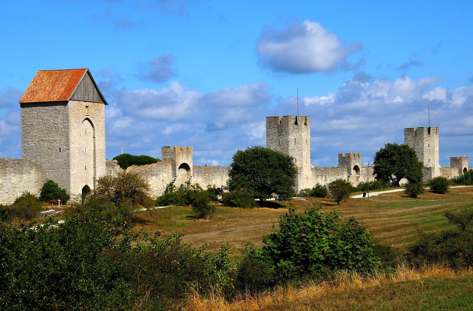
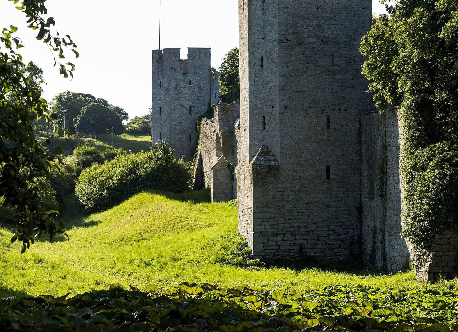
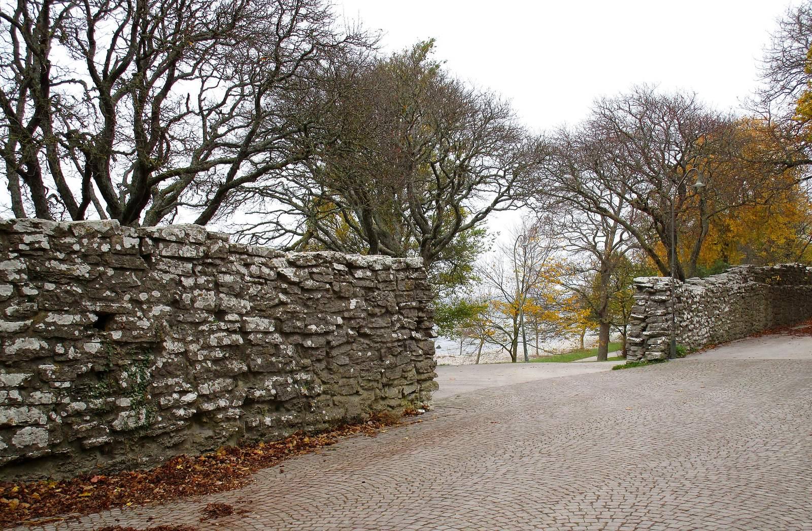
The wall surrounds Visby’s old town on a steep slope above the Baltic Sea. Its western, seaward stretch lies about two metres above sea level. To the north and south the circuit climbs the slope known as Klinten, while the ground reaches roughly forty metres above sea level to the east. The original circuit measured about 3.6 kilometres; approximately 3.44 kilometres survive. Of its original 29 large towers and 22 smaller towers built on the wall, 27 large and nine small towers remain. Substantial sections of the original ditch system also survive.
Local limestone, limestone rubble, and lime and clay mortars form the wall. In its earlier construction, two thin limestone faces enclosed a rubble core. When the wall was raised, solid limestone stabilized with lime mortar was added above the first work, with much of the later structure’s weight borne by the original outer faces. Cement was used to reinforce lime-mortar joints during 20th-century restoration.
The first landward wall stood about five to six metres high. An elevated platform for archers ran along its town side, with regularly spaced firing openings and narrow arrow slits for shooting through the masonry. The wall was later raised by another three to four metres. Existing town houses were incorporated into the defenses during one of the two construction phases.
The harbor and sea-facing wall
Kruttornet
Kruttornet stands in the former harbor area, now Almedalen park. Originally called Lambtornet, it has no ground-level door. Its small entrance, about ten metres above the ground, was reached by a removable ladder. The tower’s later use as a gunpowder store is reflected in its present name. The harbor itself disappeared as the land rose after the last ice age, and the southern harbor tower is also lost.
Lilla Strandporten
One of the oldest gates, Lilla Strandporten belonged to the first sea-facing wall. It was rebuilt during the 13th century, when the wall above it was raised and its earlier openings closed. In the High Middle Ages, the gate linked the old harbor with Roland’s Square, where the town’s first town hall stood.
Stora Strandporten
Stora Strandporten, also known as Donnersporten, stood in the western, seaward wall. Excavation in 1989 uncovered its foundations. A section of the wall survives within the town-facing front of Donnerska Huset to the south.
Kärleksporten
Kärleksporten, or the Love Gate, was cut through a collapsed stretch of seaward wall in 1872. The passage connected the waterfront promenade with the area now occupied by Visby Botanical Garden and was promoted by the De Badande Wännerna society for local fishers. Its earlier name, Tjärhålet, referred to the coating of ropes with tar nearby. It later became Tjärporten and then Kärleksporten, a change attributed to the similarity of the Swedish pronunciations. Romantic inscriptions appear on the stones around the opening.
Fiskarporten and Sprundflaskan
Fiskarporten, or Fishermen’s Gate, was built in the later Middle Ages, probably in the 15th century. It led to a small fishing harbor that may have adjoined the main harbor. Farther along the sea-facing wall, Sprundflaskan is a full-height tower, probably built in the late 14th or early 15th century over an earlier double gate. That gate was closed when a smaller opening was made in the tower. Its cannon openings and arrow slits survive; the name, used from the late 17th century, may refer to its bottle-like form.
Tjärkokeriet
Tjärkokeriet is a small building incorporated into the oldest wall. It predates the wall and may originally have been a warehouse before being raised and adapted as a defensive tower. The rectangular building has a basement and an upper room divided into two sections beneath a barrel-vaulted ceiling. Its main entrance is blocked, with traces remaining on the southern exterior; an opening above a town-side entrance may have been used to move goods. The slate roof probably dates from its use for boiling wood tar, which was used to impregnate rope made at a nearby cordage line. The building and adjacent wall may have been demolished in 1449 during fighting between forces of Erik of Pomerania and a Swedish besieging army. The extent of damage to the wall is uncertain.
Murfallet and Lübeckerbräschen
Murfallet is a collapsed stretch of the seaward wall that may include traces of an earlier tower. A mound on its seaward side may contain fallen masonry. Lübeckerbräschen, a partly collapsed section of the northern wall, yielded arrowheads during excavation. A small tower built atop the wall may have brought down a larger section when it fell, though unstable ground may also have shifted the foundations.
The northern defenses
Silverhättan
At the northwest corner, Silverhättan, also called Kames, joins the sea-facing and landward walls. Two large buttresses support it. An external wooden platform for archers once projected from its third storey, which also had a place for lighting signal fires. In the early 18th century, its arrow slits were enlarged. Silverhättan refers to a former shining roof, probably made of lead. Kames, a name used in the 17th century, derives from the Latin word for count.
Snäckgärdsporten
Snäckgärdsporten, formerly called Västerport, is one of the oldest gate towers. Slots in the passage held a vertically raised barrier, or portcullis, and additional internal walls strengthened the entrance. The name refers to Snäckgärdsbaden, a bathing area about two kilometres north of Visby.
Sankt Göransporten
Sankt Göransporten stands beyond a stone bridge across the North Trench, part of the medieval defenses. The gate served the route toward the poorhouse and the church of St George, which together formed a large complex for people with leprosy. It continued to provide access to the former poorhouse area until the early 18th century, then was blocked around the middle of that century. A fireplace may have been installed at the time for a rope-maker boiling tar inside the wall. A stone from a siege engine remains wedged in a crack on the tower’s fourth storey. Openings on both sides mark the positions of two small towers that collapsed in the 19th century; the bridge was rebuilt in 1901. The gate has also been called Andre Lång Henrik and Ödeporten.
Norderport and Mynthuset
Norderport occupies a steep slope and was originally the principal entrance for people and goods arriving from northern Gotland. A simpler gate came before the tower. The opening for its timber-lined toll barrier is still visible. The gate arch was probably changed from a rounded to a pointed shape. Outer wooden doors were protected by a portcullis; openings remain for its lifting ropes and chains, as well as for pouring water over the barrier if it caught fire. Iron rings in the outer frames may have secured a chain across the entrance. A fireplace in the chamber above the arch had a flue built into the masonry and vented above the wall crest. Traces of an external wooden archers’ gallery remain. The arrow slits were enlarged for cannons in 1710.
Mynthuset stands beside Norderport. Tree-ring analysis dates it to about 1225, and it was probably incorporated into the wall in the 1280s. Its north and east walls form part of the circuit, while the building itself sits diagonally to it and has three storeys. Blocked openings for moving goods remain in the north gable. Fire destroyed its south and west walls. Its age and position have prompted suggestions that it served as a customs house or storage building.
Långa Lisa, Lübeckerbräschen, and Tranhustornet
Långa Lisa, whose name dates to the Middle Ages, has six storeys and is the wall’s tallest tower. An inspection in 1901 found catapult stones in niches on its upper storey. East of Lübeckerbräschen stands Tranhustornet, or the Fish-Oil Tower. An 18th-century map identifies the tower as a place where fish oil was extracted. Remains of a stone house older than the wall lie to its east.
The eastern defenses
Kvarntornet
Kvarntornet is semicircular, a shape common in the Baltic region but unusual among Visby’s towers. It formed part of the first wall and remained intact when that wall was raised. Openings inside preserve evidence of an earlier archers’ gallery. The tower originally had five storeys and a crenellated top, a parapet formed by alternating raised blocks and gaps. Its town-facing side was open until a wall was added. The present gabled roof dates from the 18th century, and two stones in the facade bear cannon-ball damage. The tower was used to grind malt and grain by hand, and a small snuff factory operated there in the 19th century.
Dalmanstornet
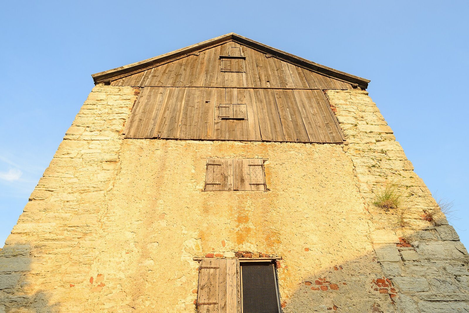
Dalmanstornet was built to defend a gate in the older wall. Parallel walls on its inner side strengthened the entrance. Above the original gate vault, the exterior preserves traces of a niche for a saint’s image or a coat of arms, probably later moved above the portcullis. The tower, about seventeen metres high, contains a barrel-vaulted room with built-in benches and an upper room with a fireplace and chimney leading to the top. In 1784 it became a barn; its open side toward the town was blocked and it received its present gabled roof. Its name refers to Gotland vice-governor L. R. Dalman.
Österport
Österport guarded the road east toward central Gotland. A five-storey tower was built over the earlier gate, with no openings toward the town on three of its storeys. The room above the gate vault had a fireplace and a latrine. In the 17th century, two parallel outer walls extended about twenty-five metres at right angles from the circuit to protect the entrance and bridges across the ditch. The road through the gate is now about a metre higher than it was when the gate was built. A Danish chronicle records that a decorative spire was destroyed by fire in 1610. The gate was armed with cannons during the unsettled 1710s. Its wooden doors are now in the Gotland Museum. Before the island’s first newspaper appeared in 1811, official notices were posted at the gates and Stora Torget.
Eastern gun platforms
Smörasken and Sparbössan are caponiers, projecting defenses designed to let guns fire along the face of a wall. Smörasken, a semicircular structure connected to a full-height tower, has a low basement and two levels for artillery. Its name appears on a 1723 map. Sparbössan lies in the East Trench about sixty-five metres south of Dalmanstornet. Its name refers to its resemblance to an old money pouch. Marks from rifle fire remain on its wall from the period when the ground in front served as a shooting range, between the 1830s and 1900.
Brunnsporten and Skolporten
Brunnsporten was built in 1863 to reach a well dug in the East Trench outside the wall. Its design, inspired by gates and churches on Gotland, differs from the other entrances. Skolporten is a small gate made when a primary school was built outside the wall in 1891. It has since been enlarged several times, and the wall was partly breached in this area.
The southern and southwestern defenses
Kajsartornet and Kajsarporten
Kajsartornet was the first full-height tower added as the first construction phase neared completion. It is square, with most of its mass projecting outside the wall, and its walls are 2.6 metres thick. It originally had no openings and may have been used for storage or as a central store for military equipment. The original rounded ground-floor entrance remains visible on its west side. The tower once had four storeys and stood higher than it does today; its uppermost floor was probably open toward the town and fitted with an archers’ gallery. An exterior staircase leads to two of the three upper floors. From the early 1680s, the tower served as the town prison. A county prison built beside it in 1782 was connected to the tower and demolished in 1886. A healer was imprisoned there in 1738. The name, known from 1750, may derive from the Swedish word for emperor.
Kajsarporten was built in 1661 and takes its name from the neighboring tower. It was first called Maria Bönderby’s Gate, after a woman who requested a passage to take her livestock out to pasture without using another entrance.
Southern towers and Söderport
Store Henrik and the other full-height towers along the southern wall were the first towers added solely for defense. Unlike later towers, they sit squarely on the wall and project toward the town as well as outward. Their sturdier construction includes features associated with the Romanesque medieval style. Grå Gåsen and Store Henrik are the circuit’s shortest towers, about twelve to thirteen metres high, compared with the usual sixteen to twenty-three metres for most towers. Their names are probably original. Stor Cristin is among the largest towers, and its name was probably already in use in the Middle Ages; a 1690 map also applies it to the adjoining property.
Söderport stands where the southern and eastern stretches of the wall meet. The gate tower may be later than some others, since no trace of an earlier gate has been found. It is finely built, with narrow joints, and survives to about 6.5 metres high. The surrounding ground has not been raised, preserving its original proportions. A stone-bench room has a groin-vaulted ceiling, formed where two barrel vaults intersect. One of two niches contains a badly eroded carving with two faces. Only the south wall of the second storey remains; that level once held a room with a fireplace. A wooden outer door stayed in its original position until 1873. Excavation in 1902 recovered medieval arrowheads and parts of firearms dating to the early 17th century from a fire-affected part of the tower. The fire may have been connected with a blaze in 1611 that damaged parts of Visby and its wall.
Skansport and Skansen Hafsfrun
Skansport was opened in 1879 to speed the movement of horse-drawn artillery out of the town and improve communications with the southern suburbs. Beside it, Skansen Hafsfrun, or the Sea-maiden Bastion, was built in 1712 outside and connected to the original wall. The bastion provided a platform for eight guns to defend the harbor and southern defenses, but it and its guns were never used in warfare.
Slottsmuren and Lantporten
Slottsmuren, or Castle Wall, occupies the southwest corner. The foundations of the former Segeltornet show that it was more strongly built than the other southern towers. Like Kruttornet, it had no openings on its town-facing side. A side wall ran down the slope from the tower to the sea, preventing passage around the outside of the seaward wall. East of the tower foundations, a section of wall and Lantporten survive. The gate belonged to the older wall and also linked the inner courtyard of Visborg Castle with its outer defenses.
Huset med målningarna
Huset med målningarna, or the House with the Paintings, was built in the mid-13th century before being incorporated into the wall. Renaissance paintings, from a European cultural and artistic movement that began in the late medieval period, cover the walls and vaulted ceiling of its upper floor. The building is entered through its town-side basement, where an old disused well remains. Doors and openings on the east and north sides indicate former exterior wooden stairs leading to an upper landing and the attic. Tradition holds that guests of Solberga Abbey once stayed there. Later uses included housing for poor residents, artisans, and merchants, as well as merchants’ premises; it is now mainly used for storage.