Milefortlet 21: A Roman Coastal Fortification in Cumbria
Site at a Glance
- Country
- United Kingdom
- Primary era
- Classical
- Eras represented
- Classical
- Civilizations
- Roman
- Site type
- Military
- Remains
- Fort
On this page10 sections
History
Milefortlet 21, also known as Swarthy Hill, is a small Roman fortification north of Crosscanonby on the Cumbrian coast of the United Kingdom. It formed part of the Roman coastal defenses of Cumbria, built in the same period as Hadrian’s Wall, the Roman frontier work in Britain. Pottery indicates a single period of occupation during the Hadrianic period, the reign of Emperor Hadrian from AD 117 to 138.
Two associated towers, 21A and 21B, were probably manned by soldiers from the nearest milefortlet’s garrison. Tower 21A was dismantled shortly before the Second World War. Tower 21B appeared in an aerial photograph taken by the Royal Air Force in 1946, was investigated in 1962, and was excavated in 1966. That work established its height and configuration.
Aerial photographs revealed cropmarks of Milefortlet 21’s ditch in 1968, about 64 m northeast of its predicted position. Excavation in 1990–1991 made it the only milefortlet to have been fully excavated.
Remains
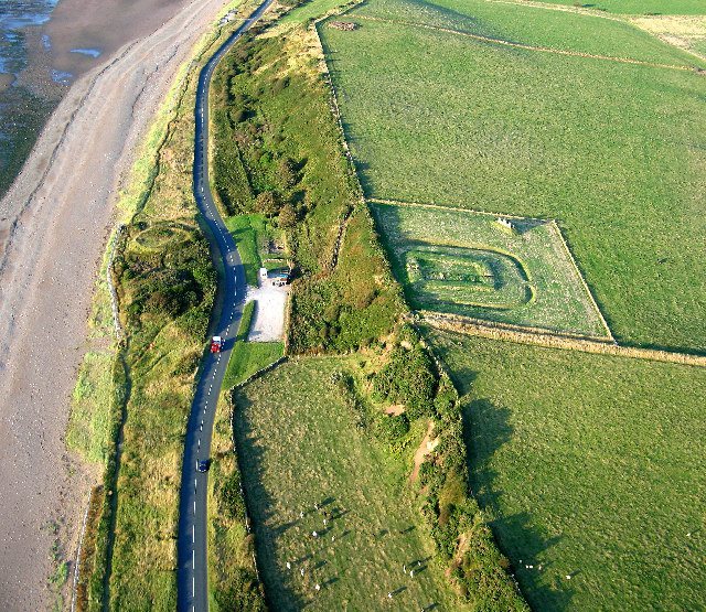
The fortlet occupied a low coastal cliff north of Crosscanonby, just inland from the coastal road. Post-medieval Allonby Saltpans lay on its seaward side. The elongated enclosure had turf ramparts 6 m wide, built with turf facings against a sand core, and an interior measuring 14.5 m by 18 m. Its ramparts have been reconstructed to about 1 m high, and the ditch has been restored to a profile about 1 m deep.
The fortlet
Defences and gateway
A ditch enclosed the fortlet except along its seaward side, with a causeway breaking the circuit at the opposite end. The seaward gateway measured 3 m square internally and was made from four posts. A road ran within the enclosure.
Southwestern buildings
Three similarly sized buildings, arranged in different ways, stood southwest of the road. They were apparently set on sleeper walls, low supporting walls beneath a building. The two nearer the sea shared a wall, while the third stood apart. A hearth was found in the seaward building, and the central building had a furnace or oven.
Northeastern building
A single building occupied most of the area northeast of the road. It measured 18 m by 5 m and was apparently divided into four bays. Each central bay contained a hearth, while each outer bay had an oven.
Excavated objects
Finds included black-burnished ware, a type of Roman pottery, grey pottery, and Samian ware, fine Roman tableware. The recovered objects also included part of a bead, a gaming board, a knife, and an unidentified item thought probably to be an adze, a cutting tool.
Associated towers
Tower 21A
Also known as Saltpans, Tower 21A stood about one-third of a Roman mile west of the fortlet, south of the junction of the B5300 and Crosscanonby Road.
Tower 21B
Also known as Brownrigg North, Tower 21B stood about two-thirds of a Roman mile west of the fortlet, on the seaward slope of Brown Rigg hill. Its buried masonry survives to about two courses, and aerial photographs show cropmarks at the site.