Merv: A Historic Silk Road Oasis City in Turkmenistan
Site at a Glance
- Country
- Turkmenistan
- Primary era
- Medieval
- Eras represented
- Bronze Age, Iron Age, Classical, Medieval
- Civilizations
- Abbasid, Achaemenid, Sassanid, Seleucid, Seljuk, Timurid
- Site type
- City
On this page24 sections
History
Merv is a historic oasis city near Baýramaly in Turkmenistan, whose earliest urban phase took shape during Achaemenid expansion in the sixth century BC. Settlement in the area reaches back to the third millennium BC and is associated with the Bactria–Margiana Archaeological Complex, a Bronze Age culture of Central Asia. Around 515 BC, the Achaemenid inscriptions at Behistun name the region as Margu, a province within the Persian empire. Zoroastrian tradition calls Merv Mouru, one of the ideal lands created by Ahura Mazda, the supreme deity of Zoroastrianism.
Early cities and successive empires
Alexander the Great’s visit to Merv belongs to legend, although the city was known for a time as Alexandria. After his death in 323 BC, Merv became the capital of Margiana under successive Hellenistic and later dynasties. The Seleucid ruler Antiochus I Soter rebuilt and enlarged the city at the site of present-day Gäwürgala, naming it Antiochia Margiana. Control later passed to the Greco-Bactrians, Parthians, and Sasanians. Around 53 BC, about 10,000 Roman prisoners captured at the Battle of Carrhae appear to have been deported to Merv. The city was also a center of Buddhist learning for many centuries before its Islamization.
Ardashir I brought Merv under Sasanian rule around AD 220–240. Apart from a brief period of Hephthalite control, from the late fifth century until AD 565, the Sasanians held it for almost four centuries. Zoroastrianism was the official religion, while Buddhists, Manichaeans, and Christians of the Church of the East also lived in the city. From the fifth to the eleventh centuries, Merv was the center of an East Syrian church province. Barshabba, its first named bishop, is dated to around 360 or 424.
Caliphal rule and the Abbasid period
Sasanian rule ended after the last Sasanian ruler, Yazdegerd III, was killed near Merv and the city’s military governor surrendered to the approaching Arab army. Forces of the Rashidun caliph Umar occupied Merv, which became the capital of the Umayyad province of Khorasan. In 671, Ziyad ibn Abi Sufyan sent 50,000 Arab troops to garrison the city. Merv then served as a base for Arab political and military activity, including Qutayba ibn Muslim’s campaigns from 705 to 715, which brought large parts of Central Asia under Arab rule.
Arab migration was substantial, and Merv and Khorasan were among the first Persian-speaking regions to develop Muslim majorities. Arabs and Persians lived in mixed communities. In February 748, the Iranian general Abu Muslim proclaimed the Abbasid dynasty at Merv and enlarged the city as a base for revolt against the Umayyads. Merv was a center of the Abbasid Revolution of 746–750. After the Abbasids established their rule in Baghdad, Abu Muslim governed Merv as a semi-independent prince until his assassination.
Merv remained the principal city of Khorasan under the Abbasids. The caliph al-Ma’mun lived there from 813 to 818, making it, in practice, the capital of the Muslim world during those years. The Barmakid family, based in Merv, helped carry Greek learning into the Arab world. The city became a center of Islamic scholarship, with scholars studying law, hadith, history, and literature. Omar Khayyam spent several years at its observatory. A major mosque had a library credited with 12,000 volumes, and Merv was counted as having as many as ten large libraries.
Merv also held religious importance for several faiths. Ali ar-Ridha, revered as the eighth Imam in Twelver Shiism, lived there for several years after leaving Baghdad. Al-Muqanna, born in Merv, led a religious and political movement, claimed to be an incarnation of God and heir to Abu Muslim, and inspired the Khurramiyya movement, which persisted in the city until the twelfth century. In 821, Tahir b. al-Husayn and the Tahirids replaced Arab rule; they governed until 873, followed by the Saffarids, Samanids, and Ghaznavids.
Seljuq power and the Mongol conquest
The Seljuq Turkmens took Merv peacefully in 1037 under Tughril, when the Ghaznavid sultan Mas’ud I was unpopular in the city. Tughril’s brother Chaghri remained there as Seljuq power grew. Merv became a favored Seljuq city: Chaghri, his son Alp Arslan, and his great-grandson Ahmad Sanjar were buried there, and Sanjar made it his residence. By the end of the eleventh century Merv was the eastern capital of the divided Seljuq state; from 1118 it was the capital of the whole empire.
Under the Seljuqs, Merv became a major center of culture and commerce. Nizam al-Mulk, a senior minister, established a large library and a madrasa, an institution of Islamic learning, alongside other cultural institutions. The city’s market was considered among the best in Iran and Khorasan. Estimates place its population at about 200,000 around 1150 and possibly 500,000 by 1210. In the twelfth and thirteenth centuries it was known as Marw al-Shahijan, or Merv the Great, and was regarded as a leading city of the eastern Islamic world.
Sanjar’s rule ended in 1153, when Turkmen nomads from beyond the Amu Darya pillaged Merv. The city later passed to the Ghurids in 1192 and the Khwarazmians in 1204. In 1221, Merv opened its gates to the Mongol force led by Tolui, a son of Genghis Khan. Nearly all the population, including refugees, were said to have been killed. Estimates of the dead range from about 700,000 to more than 1.3 million. Merv and the tomb of Sultan Sanjar were reportedly burned. The city was partly rebuilt, including its fortifications, but did not regain its former prosperity. It became part of the Ilkhanate and was repeatedly looted by the Chagatai Khanate.
Later rule and abandonment
In the early fourteenth century, Merv became the seat of a Christian archbishopric of the Church of the East under the Kartids, who ruled as Mongol vassals. By 1380 the city belonged to Timur’s empire. Uzbeks occupied Merv in 1505, but Shah Ismail I expelled them five years later. A Persian noble restored the Soltanbent dam on the Murghab, and a settlement grew in the irrigated area. After Shah Ismail’s death the region became dependent on Khiva. Abdullah Khan II of Bukhara conquered Merv in 1593, but Shah Abbas soon retook it and appointed the Safavid governor Biktash Khan Ustajlu in 1600.
Mihrab Khan Qajar became governor in 1608, beginning about two centuries of Qajar governorship. From 1715, the Qajar elite pressed for independence from Safavid rule, while Tatar and Turkmen raids threatened the oasis. Nader Shah subdued the raiders and restored Merv’s irrigation system. After his death, local Qajars declared independence and formed the Qajar Principality of Merv. In 1785, Shah Murad, the Manghit ruler of Bukhara, attacked the city and killed its ruler, Bayram Ali Khan Qajar. In 1788–1789, Shah Murad razed Merv and broke its dams. He deported the city’s and surrounding oasis’s population, estimated at about 100,000, in stages to the Bukhara oasis and the Samarkand region. These Persian-speaking Shia Muslims resisted assimilation and maintained a distinct Mervi identity; communities identified as Mervis were still noted in the region in modern times.
Merv passed to the Khanate of Khiva in 1823. Tekke Turkmens, moving north under pressure from the Persians, became the dominant power in the area by about 1856, despite Khiva’s efforts to contest their advance. Russia occupied the oasis in 1884, and the city was entirely abandoned by 1888. During the Russian advance, the officer Alikhanov entered Merv in 1882 posing as a merchant and negotiating a commercial agreement. He returned in 1884 in Russian uniform with Turkmen notables, presenting the force at Tejen as evidence of a much larger Russian presence. Local elders surrendered after concluding that neither Persia nor Britain would support them.
Excavation and heritage
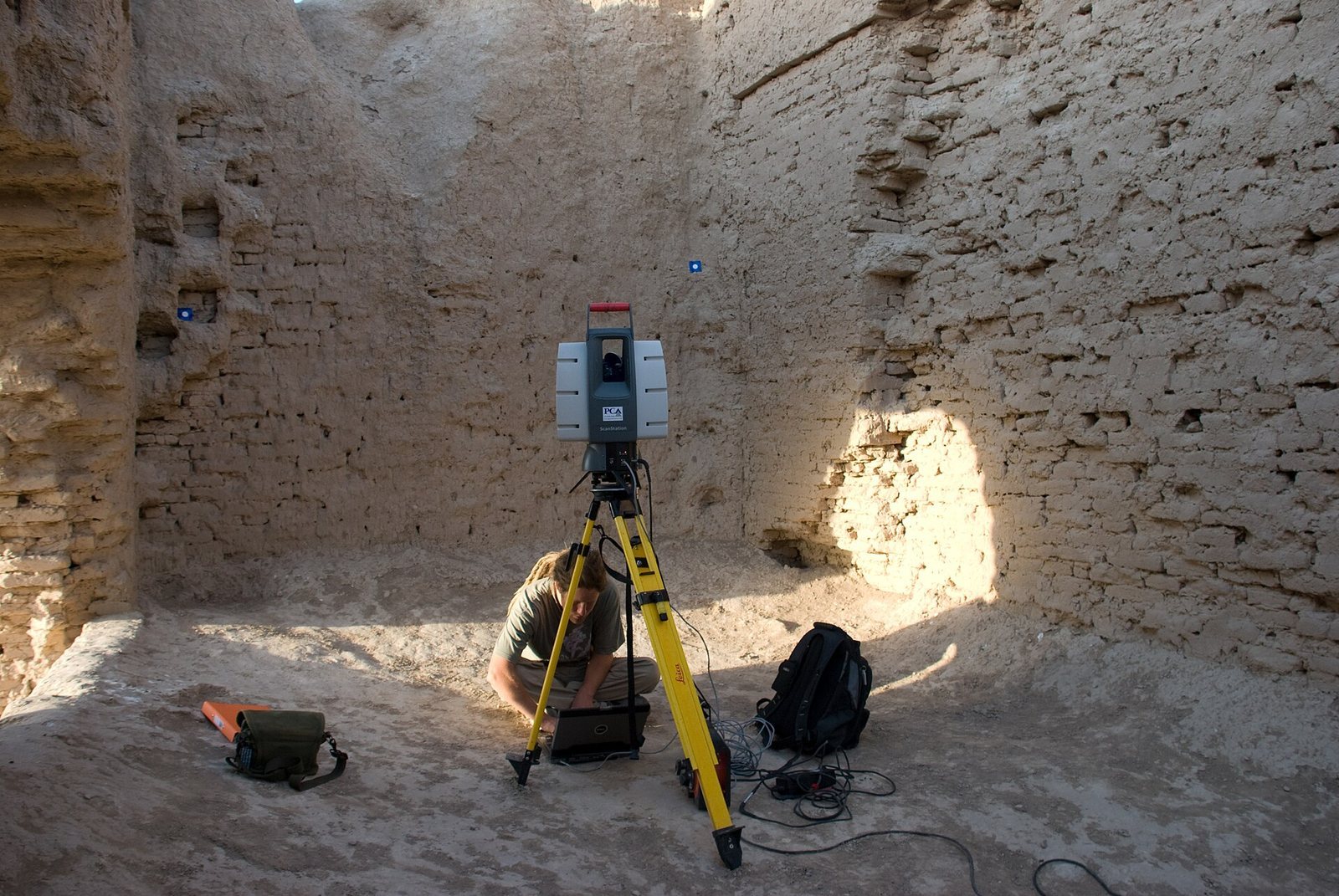
Russian general A. V. Komarov carried out exploratory excavations in 1885, using his troops as excavators, and published artifacts and coins from the area in 1900. Valentin Alekseevich Zhukovsky led the first fully professional excavation in 1890 and published its results in 1894. Raphael Pumpelly and Hubert Schmidt later directed excavations for the Carnegie Institution. Turkmen and British archaeologists worked together on the International Merv Project from 1992 to 2000; a further collaboration between University College London’s Institute of Archaeology and Turkmen authorities began in 2001, focusing on research, conservation, and site management. Turkmenistan established the State Historical and Cultural Park Ancient Merv in 1987, and UNESCO inscribed the site as a World Heritage Site in 1999. Merv is regarded as the oldest and best-preserved of the oasis cities along the historic Silk Road in Central Asia.
Remains
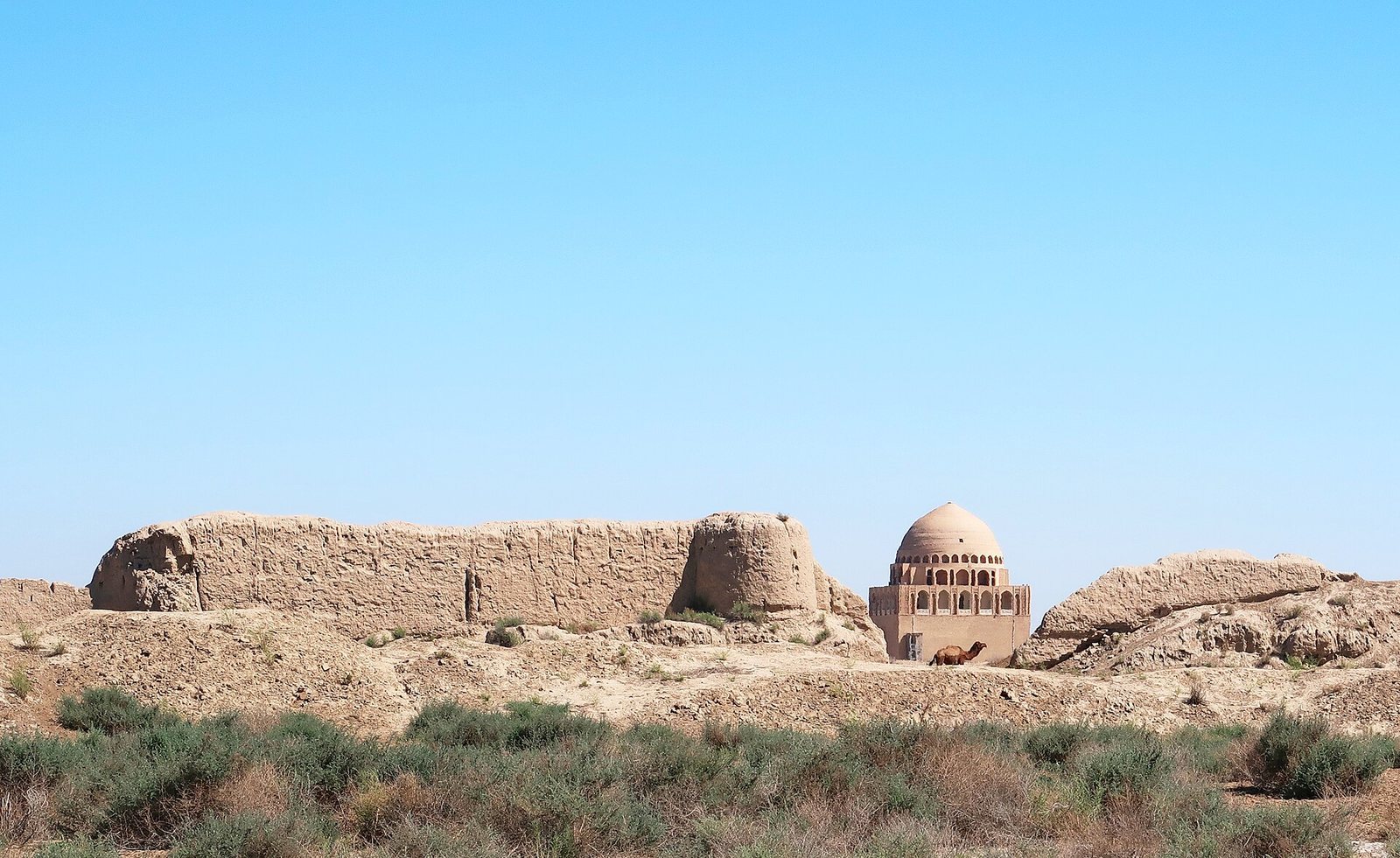
Merv occupies the inland delta of the Murghab River at the southern edge of the Karakum Desert, where regional routes met the Silk Road. The archaeological landscape consists of several separate walled cities, built in different periods on previously uninhabited ground. Their main enclosures were used, abandoned, and left unreconstructed, while ancient structures also survive between and around them. The site is now largely in ruins, although some buildings and structures remain standing.
The walled cities
The remains preserve a sequence of settlements rather than one continuous walled city. Four principal enclosures represent major phases: Erk Gala, Gäwürgala, Soltangala, and the Timurid-period Abdyllahangala. Shaim Kala forms another walled settlement within the wider archaeological landscape.
Erk Gala
Erk Gala, the oldest part of the complex, is dated to the seventh century BC. Built as a Persian-style fortress to control the oasis on the Murghab, it later served as the fortified center of the Hellenistic city and as a citadel within the Islamic city.
Gäwürgala
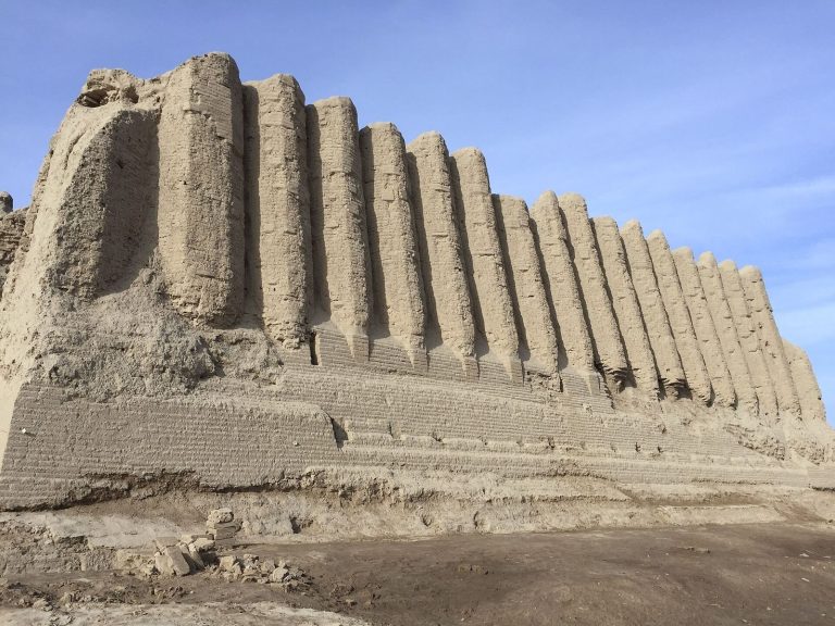
Gäwürgala surrounds Erk Gala and preserves remains of the Hellenistic and Sasanian metropolis. It later became an industrial suburb of Soltangala. Three defensive walls were built in succession. The Seleucid wall has a stepped inner face and a straight outer face; a larger mud-brick wall was raised on its platform, also stepped on the inside; and a third wall, probably Sasanian, used larger bricks. Parthian pottery fragments have been found around the walls.
Shaim Kala
Shaim Kala was built as a walled city in the seventh century AD. Its construction was intended to ease overcrowding and address religious and political discontent among newly arrived groups.
Abdyllahangala
Abdyllahangala is a small Timurid-period city founded a short distance south of the principal complex.
Soltangala and its buildings
Soltangala, the largest of Merv’s walled cities, developed west of Gäwürgala. Monumental buildings were commissioned there under Abu Muslim, and walls soon enclosed the area as the core of medieval Merv. Fortified buildings called köshks, semi-fortified two-storey residences, have been found in and around the city.
The Gyzgala residences
The Greater Gyzgala stands just outside Soltangala’s western wall. It has 17 rooms arranged around a central courtyard. The nearby Lesser Gyzgala has very thick, deeply corrugated walls and several interior stairways leading to upper-floor living quarters. In these residences, upper floors served as living space; lower floors may have been used for storage, and roof parapets also provided living areas. The köshks are in precarious condition.
Shahryar Ark and its palace
The Shahryar Ark, Soltangala’s citadel, lies on its eastern side. Its central Seljuq palace, probably built by Sanjar, had tall, single-storey rooms arranged around a courtyard and four iwans, vaulted halls open on one side, set along the courtyard’s four sides. Surviving mud-brick walls define the plan. Low ground nearby suggests a large garden with an artificial lake. Erosion or theft has removed the palace’s interior and exterior decoration.
The kepderihana
Within the Shahryar Ark is a well-preserved, long, narrow room called a kepderihana, a name meaning pigeon house. It has no windows and contains many tiers of wall niches. Its function remains uncertain: it may have housed pigeons whose droppings were collected for melon cultivation, or it may have served as a library or treasury.
Sultan Sanjar’s mausoleum
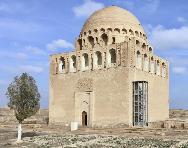
The twelfth-century mausoleum of Sultan Sanjar is square, measuring 27 metres on each side, with entrances on opposite sides. Ribs and arches arranged in an octagonal system support its large central dome. The dome’s exterior was turquoise. Early Seljuq decoration included interior plasterwork and geometric brick patterns on the outside, most of which has been lost. The mausoleum remains largely intact, and some exterior decoration has been reconstructed.
Walls and suburbs
Soltangala’s Seljuq defenses began as mud-brick walls eight to nine metres high. Internal chambers allowed defenders to shoot arrows, and horseshoe-shaped towers stood at intervals of 15 to 35 metres. By the mid-twelfth century, the walls had been reinforced by filling their galleries and adding a smaller wall in front. The medieval suburbs, now called Isgendergala, were enclosed by a wall five metres thick.
Water, workshops, and pottery
Irrigation and craft production
The Soltanbent dam on the Murghab was restored, and canals carried river water into the oasis. Cotton seeds from fifth-century levels provide evidence for the importance of cotton textiles to the Sasanian city’s economy. Gäwürgala preserves an unbroken series of Sasanian coins and Abbasid-period pottery kilns and workshops for working steel, iron, and copper. One pottery kiln retains its arched support and square firepit; the district appears to have been a craftsmen’s quarter in Abbasid and pre-Seljuq times. A ninth- to tenth-century workshop made crucible steel by melting and combining cast iron with wrought iron.
Ceramic evidence
Excavated ceramics reflect different periods and parts of Merv. Late Abbasid Gäwürgala yielded mainly red-slip bowls with geometric patterns. Pottery found by Soltangala’s walls is chiefly yellow and green with splashed colors and dates to the eleventh and twelfth centuries; finds from the Shahryar Ark include turquoise and black bowls. A deposit of Mongol-style pottery in the Ark may relate to an unsuccessful Ilkhanid effort to refound the city.
Religious and other remains
Buddhist remains
Buddhist stupas and monastery-temple remains are associated with Gäwürgala and Baýramaly. In Soltangala’s southern suburbs, a ceramic mask used as wall decoration came from a structure interpreted controversially as a Buddhist temple built under Mongol rule.
Other identified structures
Other features identified at Merv include a mosque, an ice house, the Kyz Bibi mausoleum complex, and the tomb of the Eskhab brothers. The Eskhab tomb lies within the territory of ancient Merv.