Zorats Karer: A Stone Monument and Disputed Observatory in Armenia
Site at a Glance
- Popularity
- High
- Country
- Armenia
- Primary era
- Bronze Age
- Eras represented
- Bronze Age, Iron Age, Classical
- Civilizations
- Armenian
- Site type
- Burial
- Remains
- Necropolis
On this page16 sections
History
Zorats Karer is a stone monument on a mountain plateau near Sisian, Armenia. Its date and purpose remain disputed: interpretations range from a cemetery to a place of astronomical observation, and the Armenian government designated it as an observatory in 2004.
Names, dates, and proposed purposes
The site is also called Carahunge or Karahunj. In the 1990s, academician Paris Herouni proposed the name Carahunge, often interpreted as “speaking stones,” from words for stone and sound or echo. That interpretation has been linked to whistling said to come from the stones in windy weather. Another explanation connects the name with Carunge, a village near Sisian mentioned by the thirteenth-century historian Stepanos Orbelian, and translates it as “stone treasure” or “foundation stones.” The Turkic name Goshun-Dash means “troop stones.” A folk tradition associated with it says that a commander was buried in a stone tomb and his warriors beneath separate stones.
Proposed dates for the monument vary widely. Herouni used astronomical, physical, and mathematical calculations to argue that it was more than 7,500 years old. Other estimates range from about 5,700 to 2,000 BCE. Archaeological interpretations place the cemetery mainly between the Middle Bronze Age and the Iron Age, while archaeologist Ashot Piliposyan has estimated the monument at about 4,000 years old. These differing dates reflect the continuing debate over what the stone complex was built to do.
Herouni and other researchers argued that the stones had an astronomical purpose. He associated the central circle and northeast alley with ceremonies for Ar, the sun god, and said the alley aligned with sunrise at the summer solstice. Other interpretations connect 17 stones with sunrise or sunset at solstices and equinoxes, and 14 with extreme positions of the Moon. Researchers have proposed different explanations for the northeast alley, linking it to the summer solstice, the Moon’s major northern standstill, or the rising of Venus. The site may have served both as a burial place for an important person and as a setting for astronomical ritual.
Investigations and changing interpretations
Archaeologist Onik Khnkikyan explored possible astronomical connections in 1984, followed by astrophysicist Elma Parsamyan’s proposal of an observatory interpretation in 1985. Herouni led investigations at Zorats Karer and nearby areas in 1994–97, 1999, and 2001. In 1999, he exchanged letters with astronomer Gerald Hawkins, who praised his calculations and expressed agreement with his conclusions.
A Munich archaeological team surveyed the site in 2000 and identified a cemetery dating mainly from the Middle Bronze Age through the Iron Age. Team leader Stephan Kroll proposed that the stone rows might be parts of a city wall from the Hellenistic period, the era following Alexander the Great’s conquests. In this interpretation, the wall was built chiefly from rubble and loam, with upright stones reinforcing it. In 2001, Russian astronomy professor N. G. Bochkaryov and colleagues interpreted a fallen stone near N90 in the southern arm as a possible astronomical viewing device. In 2003, Bochkaryov argued that the site was more than 7,500 years old and called it the world’s oldest observatory.
Official recognition and recent research
On 29 July 2004, the Armenian government officially designated the site the “Karahunj (Carahunge) Observatory.” President Robert Kocharyan ratified the decision on 11 August. The designation gave the observatory interpretation official recognition, but the site’s purpose continued to be contested. In September 2010, an Oxford University and Royal Geographical Society expedition surveyed the stones to assess earlier findings and create three-dimensional maps. Its leader, Oxford astrophysicist M. Vardanyan, said the site might be one of the world’s oldest observatories.
Zorats Karer became a state-protected historical and cultural reserve in 2009. Excavations within the reserve began in 2013 under Piliposyan, who argued that the site was a burial ground rather than an observatory. His interpretation renewed public and scholarly debate about how the stones were used.
Remains
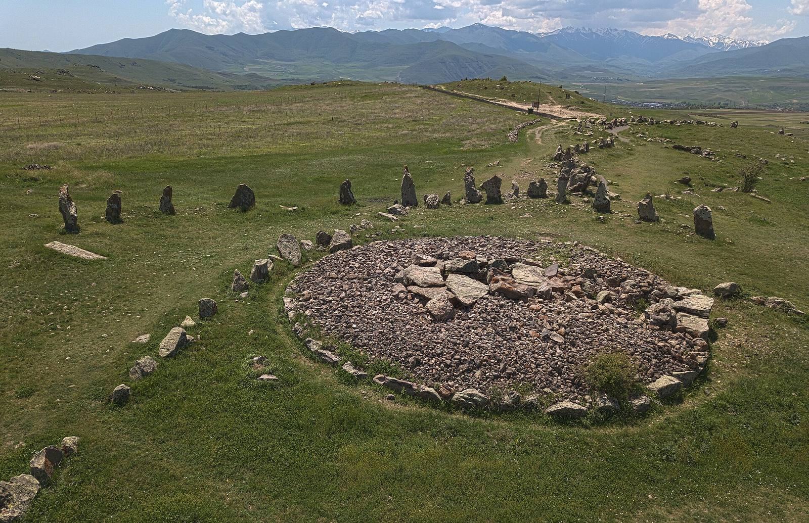
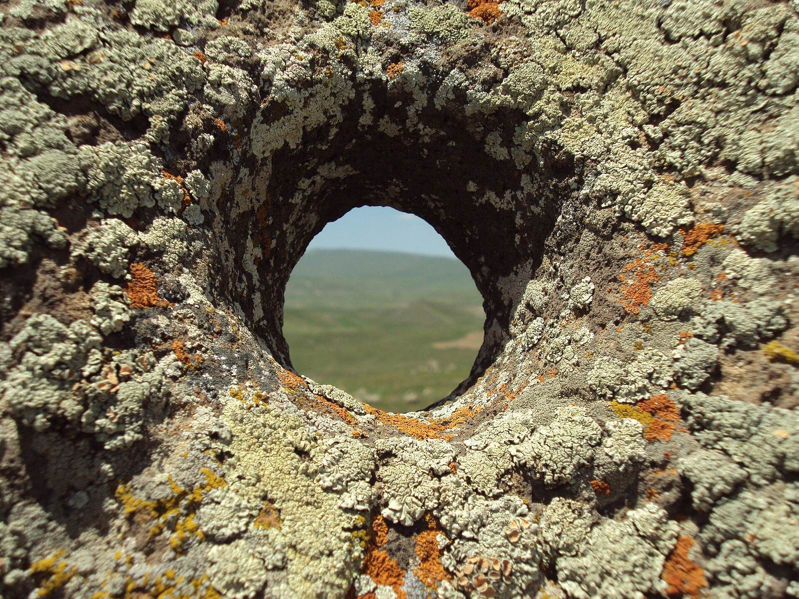
Zorats Karer occupies a rocky promontory on a mountain plateau about 1,770 metres above sea level. The complex covers about seven hectares beside the Darb canyon, on the left side of the Darb River, a tributary of the Vorotan. Its irregular rows run broadly northwest to southeast, with an oval central arrangement and passage-like openings on opposite sides. The 223 numbered stones are basalt, about 0.5 to 3 metres high and weighing as much as 10 tonnes; many other stones and fragments are unnumbered. The stones were quarried in the nearby Darb gorge and moved with woven ropes and draft animals. Many are weathered, covered in moss and lichen, or broken.
Central area and main arms
Central circle
Forty stones form the central circle, an oval whose pointed end faces west. A mound or cluster of ruins at its centre measures about 7 by 5 metres and has been proposed as the remains of a religious temple. Its proportions have been compared with those of the Temple of Garni. The central area also contains an inner circle, a stone mound, and a stone-box grave beside the mound.
North arm
The north arm extends for 136 metres and comprises 80 stones, 49 of them perforated. At its northern end, it divides into western and eastern rows, each about 50 metres long. Paved paths, 1 to 1.5 metres wide, run through the area. Small stones on the opposite side of the paths may have served as seats during observations.
South arm
The south arm runs 75 metres south from the central circle, then turns west-southwest and continues for more than 40 metres. Its 70 stones include 26 with holes. Paved paths measuring 1 to 1.5 metres wide and small stones that may have served as observation seats are also present here. Beyond the arm’s end are circular graves measuring 3 to 8 metres across.
Alley, cross-line, and separate stones
Northeast alley
The northeast alley is 36 metres long and eight metres wide. It consists of eight stones, two perforated, and rises about half a metre above the surrounding ground.
Line across the circle
A row of 20 stones crosses the central circle and links the north and south arms. Six stones in this line have holes.
Isolated stones
At least five standing stones lie east and west of the main complex, at distances of up to 90 metres or more; one is perforated. Scientist H. P. Kleiner proposed that the isolated stone N200 had a role comparable to the Heel Stone at Stonehenge.
Perforated stones and burial features
Stone holes and carved features
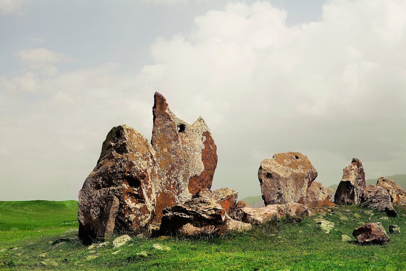
About 80 stones have circular holes near their tops. Of these, 37 remain upright and contain 47 holes. Each hole is about 4 to 5 centimetres wide, begins 15 to 20 centimetres below the stone’s top, and widens toward both openings to as much as 12 centimetres. The holes were made with fired-clay tools containing obsidian, a natural volcanic glass. Some are angled in a way consistent with drilling from both sides. Their inner surfaces are smoother and better preserved than the stone exteriors, a condition that has prompted questions about whether the holes date to prehistoric times.
In 1995, Kleiner noted a carved recess in stone N68 that held rainwater, as well as an angle formed by reflected sunlight and the top of stone N69. He also identified tools that he considered potentially astronomical. Herouni’s team mapped the site, recorded the numbered stones’ dimensions and condition, measured the directions of the holes, and surveyed elevations along the surrounding mountain horizon. Magnetic-field measurements within the central circle traced a spiral pattern.
Graves and smaller stone arrangements
A small cromlech, or circular arrangement of smaller stones, is also present. A burial was found beneath a menhir, meaning a large upright standing stone. Together with the graves beside the central mound and beyond the south arm, these features form part of the evidence for interpreting Zorats Karer as a burial ground.