Las Médulas: A Roman Gold-Mining Landscape in Spain

Site at a Glance
- Rating
- 4.7
- Popularity
- Medium
- Country
- Spain
- Primary era
- Classical
- External website
- Open
- Eras represented
- Classical
- Civilizations
- Roman
- Site type
- Economic
- Remains
- Mine
On this page12 sections
History
Las Médulas is an abandoned Roman open-pit gold-mining complex in El Bierzo, León, Spain. Roman exploitation probably began under Emperor Augustus, the first Roman emperor, whose campaigns from 26 to 19 BC completed the conquest of much of northern Iberia. Large-scale production began during the second half of the 1st century AD, and the mining operation later created a cultural landscape that combined engineered terrain, waterworks, vegetation, and agricultural use.
Before and during Roman exploitation
Indigenous communities had worked the gold deposit before the Roman conquest by panning alluvial sediments, the river-laid gravel, sand, and silt that contained naturally concentrated gold particles. The Romans transformed this earlier activity into a large industrial operation. Their method removed enormous quantities of earth from the hillsides and transported gold-bearing material to washing areas.
Pliny the Elder, a Roman author and administrator who served as procurator in the region in AD 74, described annual production of 20,000 Roman pounds of gold and a workforce of about 60,000 freedmen. Other calculations, based on the amount of earth removed, estimate between 10,000 and 20,000 workers when suppliers and guards are included. Modern studies have produced much lower estimates, proposing less than 25 kilograms of gold per year over roughly two centuries, or less than 5,000 kilograms altogether. Another calculation attributes 500 million cubic metres of displaced earth to the workings and, using an average yield of 3 grams per tonne, arrives at 1,635,000 kilograms. These differing figures reflect the difficulty of calculating production from the surviving landscape.
Abandonment and the making of a cultural landscape
The mine was abandoned in the late 2nd or 3rd century AD, when the deposit was considered exhausted. After extraction ended, native vegetation recolonized the altered ground. Chestnut cultivation expanded across the area, and some surviving chestnut trees are catalogued as more than a century old. Agriculture, particularly chestnut and cherry cultivation, remains part of the surrounding landscape. The land is communal, while individual trees, especially chestnuts, are privately owned and managed by people from nearby villages.
The name Las Médulas has several proposed explanations. It may derive from local words for conical haystacks or piles, perhaps linked to the Latin meta. Other interpretations connect it with metalla, meaning mines or metals, or with Mons Medulius. The location of Mons Medulius remains disputed, and the present place-name has not been established as a reference to that mountain.
Archaeology, protection, and interpretation
Systematic archaeological research began in 1988 through the Social Structure and Territory-Landscape Archaeology research group of the Spanish Council for Scientific Research. Together with earlier work by Claude Domergue, this research examined pre-Roman and Roman settlements and encouraged an interpretation of Las Médulas as a cultural landscape rather than solely as a mine. Aerial LIDAR surveys in 2014, using laser pulses to measure terrain and reveal features within or beneath vegetation, confirmed the extensive reach of the Roman workings.
Las Médulas became a Spanish Bien de Interés Cultural, a formal designation for a place of cultural significance, in 1996. UNESCO inscribed it as a World Heritage Site in 1997, and it was declared a Natural Monument in 2002. It is also managed as a Cultural Park and treated as a cultural landscape. The World Heritage designation covers the principal mining zone and the spoil areas of Balouta, Valdebría, and Yeres, together forming a listed area of 2,208.2 hectares. The inscription was controversial: Thailand objected that the landscape resulted from destructive human activity and conflicted with environmental-protection principles, while Germany and Finland supported that position.
Since the World Heritage inscription, the Las Médulas Foundation has monitored management of the Cultural Park with public and private stakeholders from local, regional, and national levels. A quarry near Las Médulas was declared illegal in 2008 but was still reported to be operating in 2014.
Remains
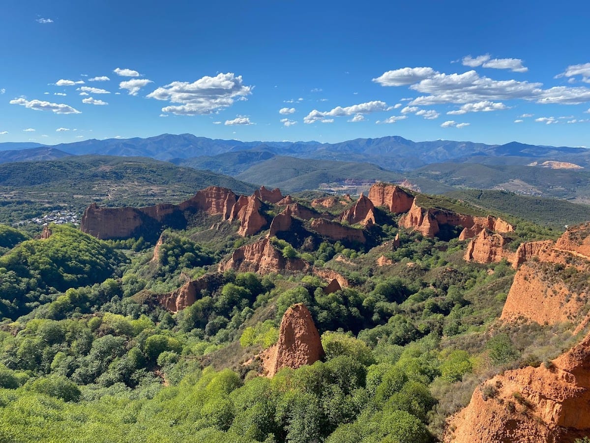
Las Médulas preserves reddish sandy formations, irregular excavated landforms, spoil accumulations, artificial drainage features, and a wide network of Roman water channels. The altered terrain is interwoven with oak and chestnut woodland, while the principal mining zone connects with the spoil areas of Balouta, Valdebría, and Yeres. Together these features show how extraction reshaped both the mountain and its surrounding water system.
Hydraulic mining works
Water channels and reservoirs
The Romans used ruina montium, meaning “wrecking of the mountains,” a hydraulic method that undermined slopes with steep galleries and then broke them apart with large quantities of water. The water carried gold-bearing earth toward washing areas, where it was screened and filtered. A network of channels diverted and stored mountain water above the workings. Across the wider system, the channels extended for more than 400 kilometres, with some individual branches exceeding 100 kilometres.
One water-capture system began on the northeastern slope of Mount Teleno, at elevations reaching about 2,000 metres. Meltwater entered the Cabo River, a tributary of the Cabrera, and fed seven channels that ran around the mountain toward the mine’s reservoirs. These channels are estimated to have a combined length of approximately 300 kilometres. They generally had gradients of 0.6 to 1 percent, a normal width of 1.28 metres, a width of 1.60 metres on curves, and a depth of 90 centimetres. Some sections passed through tunnels cut beneath the rock. Parts of the channels remain well preserved in steep locations, and some carry inscriptions cut into the rock.
Water from the channels entered reservoirs formed by levelling and excavating the ground. The removed earth was piled around them as embankments, while sluice gates controlled the distribution of water. The canals were among the most difficult and costly elements of the mining operation, and their surviving traces extend well beyond the principal extraction zone.
Orellán Water Gallery
The Orellán Water Gallery is an approximately 100-metre-long passage excavated as part of the water-conveyance system. It belongs to the same engineered network that brought water to the mining workings and illustrates the use of galleries in the hydraulic operation.
Mining formations and associated archaeological areas
Medulillas and the cave galleries
The excavations known as the Medulillas lie near the Reirigo caves and the Chaira Cave. Chaira Cave extends for more than 250 metres. Archaeological excavations occur in caves in the Reirigo area, while several other galleries are located beside the Orellán viewpoint. La Cuevona and La Encantada are named cave features associated with the Senda de las Valiñas.
Orellán settlement
Orellán was the site of a Roman fortified settlement, or castro, a defended settlement associated with pre-Roman and Roman-period communities in northwestern Iberia. The Orellán viewpoint is associated with the nearby galleries and overlooks the mining landscape.
Routes, terrain, and water-formed landscape
Mount Placias, which rises to 1,025 metres above sea level, forms part of the terrain bordering the route toward Campo de la Braña and the Medulillas excavations. Las Pedrices is a named fork near the Medulillas area, and its name is connected with murias, accumulations of stone associated with the mining landscape. The Senda de las Valiñas is approximately 4 kilometres long, while the Senda Reirigo, Senda perimetral, and Senda de los conventos extend for about 5.5, 5.7, and 4.5 kilometres respectively.
Sediment accumulation from the mining operation produced Lake Carucedo, an artificial lake associated with the Roman works. Local tradition attributes its formation to stagnant water used during extraction. The present environment includes oaks, broom, Genista tridentata, holm oaks, holly, chestnuts, and other vegetation. More than 100 bird species occur in the area, particularly on the slope of the Cabrera River, and recorded fauna includes wild boar, roe deer, and wildcat. Near Lake Carucedo, an orchid with a flower resembling a bumblebee attracts insects for pollination, while insectivorous birds are prominent in the riparian woodland.